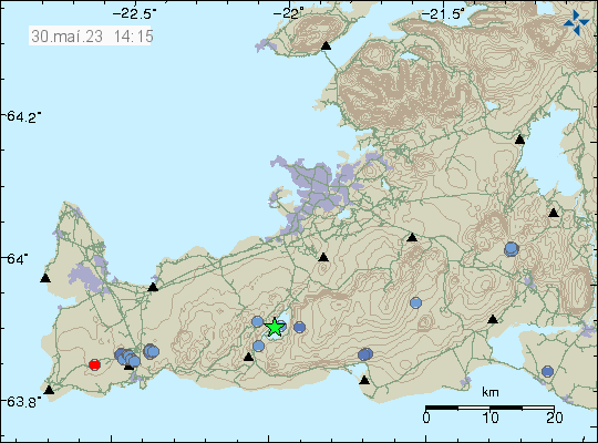
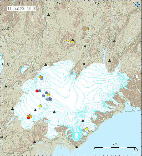
Today (30. May 2023) an earthquake took place in Krýsuvík volcano in Kleifarvatn lake. This earthquake had a magnitude of Mw3,1. I don’t know if this earthquake was felt, it is possible. This earthquake is the second earthquake in this magnitude range in last few days.
Earthquake activity in Keifarvatn lake. Copyright of this image belongs to Icelandic Met Office.
This seems to be normal earthquake activity, it doesn’t seems to be connected to any magma movement in Krýsuvík volcano. Effects of inflation in other volcanoes (Fagradalsfjall volcano) is something that might be starting to create earthquakes. This is difficult to see in the data at the moment, but that might change in next few weeks if that is happening.
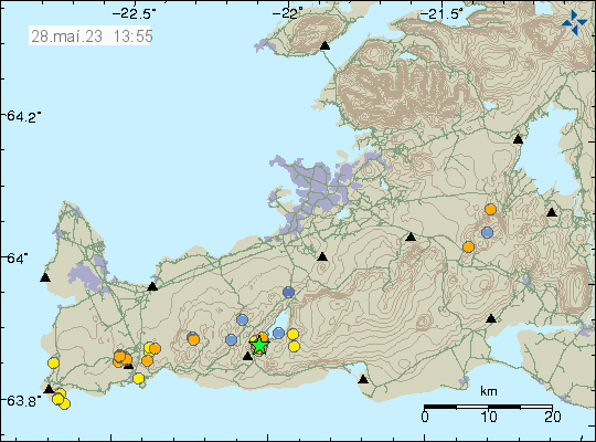
Yesterday an earthquake swarm started in Krýsuvík-Trölladyngja volcano. This earthquake swarm doesn’t appear (it might be connected, but it is difficult to know currently) to be connected to the inflation that is happening at Fagradalsfjall volcano. Largest earthquake in this earthquake swarm had a magnitude of Mw3,0. This earthquake swarm took place just south-west of Kleifarvatn lake.
Earthquake activity in Krýsuvík volcano. Copyright of this image belongs to Icelandic Met Office.
This earthquake swarm doesn’t seems to indicate an magma movement. There has not been any indicators (clear) that Krýsuvík-Trölladyngja volcano has gone active. It remains a dormant volcano.
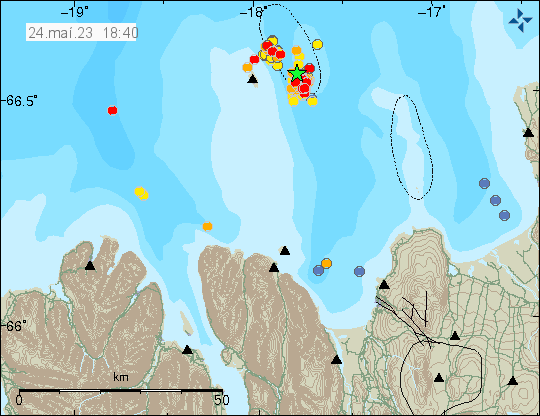
Yesterday (23. May 2023) at 19:22 UTC an earthquake swarm started east of Grímsey island. Largest earthquake had a magnitude of Mw3,8 at the writing of this article. This earthquake swarm is ongoing. The largest earthquake was felt in Akureyri and other nearby towns.
Earthquake activity east of Grímsey island. Copyright of this image belongs to Icelandic Met Office.
Around 130 earthquakes have happened in this earthquake swarm so far. This area of Iceland has frequent earthquake activity. This earthquake swarm might increase, as they sometimes do in this area. It is impossible to know when this activity is going to stop. It took me a little longer to write this article, because this is a frequent earthquake area and I was also trying to get a little break (I also have to do other things outside of this) in next few days from geology. How that goes is to be seen.
I also want to point people out that I have set-up a website that shows Icelandic Met Office harmonic tremor charts and other information for that area.
I also have a webicorder website with an earthquake recording that I run. I am trying to figure out how to install and run seismometer in Iceland again. Its a slow work in progress for me because of the technical problems I am dealing with.
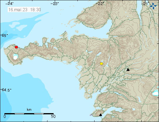
A single earthquake took place in Snæfellsjökull volcano today (16. May 2023) at 14:46 UTC. This was a single Mw2,0 earthquake with depth of 0,1 km. This earthquake was 5,4 km east of Hellisandur town. If this earthquake was felt is not known to me (nothing reported in the news).
Earthquake in Snæfellsjökull volcano. Copyright of this image belongs to Icelandic Met Office.
It is rare to see earthquakes like this on Snæfellsjökull volcano and this is the first earthquake I write about from Icelandic Met Office data. Research has shown that small earthquake activity does regularly happen in Snæfellsjökull volcano.
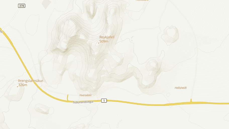
The Icelandic Road administration did send out this news report today that new hot springs have been detected at Hveradalabrekka on Road 1 in Hengill volcano. This is an area that sees some heavy traffic. I can’t post pictures here because of copyright, but they can viewed in the news article below.
According to the Icelandic Road administration it seems that the area in question has been getting warmer for some time. According to them the current temperature around 86 degrees celsius. This is the area on a map from ja.is website.
The main road 1 on Hengill volcano. Close to the area that is now warming up. Screenshot of map from ja.is.
Next is to check why this is happening and if there is any risk the Road 1 in this area and if anything can be done if that’s the case. I am unclear on what is going on, since this area (I don’t think this one, but nearby) is known for hot spring activity. There has been some earthquake activity at this location in recent months and that is possibly connected to this new hot spring activity. On 9th of May this area had a Mw1,1 earthquake at the depth of 4 km. Over a time period of 130 days, the number of earthquakes in this area is not unusual for Hengill volcano or Reykjanes peninsula in general. This area of Road 1 might continue to get warmer over the next few months.
Rúv has published a news about this and has a video of the area where this new hot spring activity is happening. This is new because vegetation is in this area and is now dying off.
Today (11. May 2023) there was a earthquake swarm in Þórðarhyrna volcano. This are small earthquakes, but their location and depth suggest that this is a dyke intrusion taking place at this location.
Earthquake activity in Þórðarhyrna volcano. Copyright of this image belongs to Icelandic Met Office.
Þórðarhyrna volcano is part of Grímsfjall volcano fissure swarm, that connects to Laki eruption fissures. Last eruption in Þórðarhyrna volcano was in the year 1902 to 1904 and had the VEI=4 according to Global Volcanism Program report that can be read here.
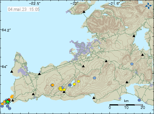
During the night of 4. May 2023 an earthquake swarm took place in the Reykjanes volcano out in the ocean. This was not a large earthquake swarm. Largest earthquake recorded had a magnitude of Mw3,4. Other earthquakes where smaller in magnitude.
Earthquake swarm in Reykjanes volcano. Copyright of this image belongs to Icelandic Met Office.
This earthquake activity suggests an dyke intrusion in this area. This is part of Reykjanes volcano, but that volcano is in part out in the ocean. The Reykjanes volcano has been having regular dyke intrusion in recent years without it resulting in an eruption. That is most likely what is going to happen now.
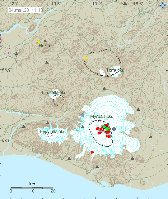
This morning there was a strong earthquake swarm in Katla volcano. At the writing of this article the largest earthquake had a magnitude of Mw4,8 and the second largest earthquake had a magnitude of Mw4,7, the third largest earthquake had a magnitude of Mw4,5. This earthquakes where felt in nearby farms and towns close to Katla volcano. Currently, a lot of smaller earthquakes have happened in Katla volcano.
Earthquake activity in Katla volcano. Copyright of this image belongs to Icelandic Met Office.
There are no changes in harmonic tremor levels at the writing of this article. That makes an eruption unlikely to happen now. That might change later without warning. The air aviation code has been moved to yellow and can be viewed here.
I’ll write a new article if something more happens.