British Geological Survey costs the set-up of six seismometers around Eyjafjallajökull and Katla

According to Rúv it appears that British Geological Survey did pay for the set-up of six seismometers around Eyjafjallajökull and Katla volcanoes. This seismometers are able to detect lower frequencies better then current seismometers around Eyjafjallajökull and Katla. This type of sensors are normally called broadband seismometers and have frequency range down to 0.001Hz and up to 60Hz. I do not know how far the sensors that BSG did cost. But I am going to assume that they go down a bit farther then IMO sensors in the area. According to Rúv the sensors are already up and where on-line earlier this year.

They are located at following location.
Mælifellssandi not far from Slysaöldu, Rjúpnafell east of Mýrdalsjökul, two are located both sides of Eyjafjallajökull on Ásólfsskálaheiði at south and Smjörgili at north not far from Gígjökli glacier. Fifth sensor is going to be set-up in Pétursey in Mýrdal. The location of the six sensors has not been decided yet.

The cost of this project is about 100.000 pound according to Rúv.

The reason for this is that authorities in UK (and Europe) want to get more warning if there is a big eruption in Katla volcano. Mostly to prevent the air chaos that took place when Eyjafjallajökull erupted earlier this year.

Five sensors where in the area before. The sensor net is going to be really sensitive when the new sensors go on-line at IMO headquarters in Reykjavík. But more sensors give more accurate location of earthquakes, both in depth and location.

The news from Rúv in Icelandic. Use Google Translate at own risk.

Bretar setja upp jarðskjálftamæla (Rúv.is)

Current ongoing earthquake swarms in Iceland

At current time there are two main earthquake swarms taking place in Iceland. The first one is at Krísuvík volcano and has been going on since early this week. Currently there is nothing to suggest that it going to end any time soon. This earthquake swarm however sometimes stops for several hours and up to one to two days at the longest. Most of the earthquakes taking place are less then mag 2.5 in size. It is not clear why this earthquakes are taking place. This might be tectonic process or something to do with the magma intrusion that is taking place in Krísuvík volcano.

The second earthquake swarm is taking place at Herðubreiðartögl with earthquake taking place at Herðubreið at it’s north limits. Several mag 3.0+ earthquakes have taken place. This earthquakes appears to be due to tectonic process in the area. But I have heard theories that this process might have started due to influx of magma into the Askja volcano that is close to earthquake swarms in Herðubreiðartögl. At current time I cannot confirm that this ideas are correct or not. This earthquake swarm is ongoing and does not appear to be ending. But there are breaks in it that last from few hours and up to one day at the longest. Please note that Herðubreiðarfjöll is a central volcano that is active. It is not on the GVP volcano list for the area. This volcano is located inside Askja fissure swarm and has many active fault lines that cross it from north-south.

The newest earthquake swarm that appears to be at slow start is taking place in Esjufjöll volcano. But since activity started there in early October 2010 earthquakes appears to be on the rise in Esjufjöll volcano. It is worth noticing that earthquake swarms in Esjufjöll appear to start slowly but they due appear to peak after 20 to 180 hours after they starts. This earthquake activity is due to new flow of magma into Esjufjöll volcano.

Maps of geology in Iceland

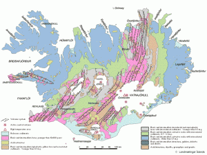
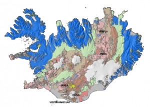
Here are two maps of the geology in Iceland. The first map shows the fault zones with the active volcanoes in Iceland. Also in this map the age of the rock is shown. The second map shows the rock type, if it is acid, basic and so on.


A map of Iceland with fault zones and active volcanoes. This map is not up to date with newest research and stuff like that. Click on the picture to get a full size.


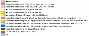
This map shows rock type in Iceland. Explanation is to the right. Click on the picture to get a full size.

Both pictures are from this web site here.

New Geophone station (hopefully) starting in January 2011

I am going to setup a new Geophone station in January 2011. The station is going to be located on the Vatnsnes peninsula where i currently live (Hvammstangi). But it is going to be located on a remote farm in that area.

I still need to by few things for this station. What I am currently missing is a GPS clock (going to buy that in two weeks time or so), WLAN hardware and antennas for getting a WLAN signal over 500 meters distance and a PC for the software that reads the data from the geophone. If everything works out I should be able have the station up and running before I move to Denmark. This station is going to take over the job of Hvammstangi geophone station that I currently have at my home.

Geothermal areas in Krísuvík volcano (videos)

Text is from youtube video!

Madly bubbling and spectacularly bad smelling hot spring area near Krisuvik, about an hour’s drive South of Reykjavik in Iceland

Text is from Google Video!

Fúlipollur í Krísuvík – The name literally means foul puddle.

Text is from youtube video!

( video 2002, Iceland). The geothermal area Krýsuvík is situated on the Reykjanes peninsula in Iceland. It is in the south of Reykjanes in the middle of the fissure zone on the Mid-Atlantic Ridge which traverses Iceland diagonally from the south-west to the north-east of the island.

Krýsuvík is one of Iceland’s high temperature areas. This becomes visible through the sulphur springs and hot springs at Seltún and another similar area nearby.

At Seltún, one finds by now some explanations to the phenomena to see, a wooden show path and hiking trails leading up the mountain Sveifluháls behind.

KrýsuvíkThe biggest lake in the area, Kleifarvatn, began to diminish after a big earthquake in 2000; 20% of its surface has since disappeared.

Some of the minor lakes show also the influence of volcanism, so for example Grænavatn with its luminous green colour.

In this area, there had been some farms till the 19th century. But they had to be given up. Only a small chapel, Krísuvíkurkirkja built in 1857, remains and can be visited.