New SIL seismometers around Eyjafjallajökull volcano and Mýrdalsjökull (Katla)

The seismometers that British Geological Survey did pay for to be installed around Eyjafjallajökull volcano and Mýrdalsjökull (Katla volcano) have been integrated into the Icelandic Met Office SIL Seismometer Network. They have at least been marked into the Icelandic Met Office earthquake web page.


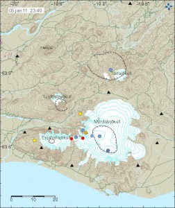
Image is from Icelandic Met Office. Copyright of this picture belongs to them.

The new stations are marked with a triangles on the map. The older SIL stations can be found at Icelandic Met Office tremor web page. Currently the new SIL stations are not on Icelandic Met Office Tremor web page yet.

What this means for earthquake recording in this area is that Icelandic Met Office is now able to detect smaller earthquakes. Location of earthquakes is also going to improve a great deal, so automatic location of earthquakes is going to improve a great deal in this area. This means that more earthquakes are going to be visible on Icelandic Met Office maps then before.

British Geological Survey costs the set-up of six seismometers around Eyjafjallajökull and Katla

According to Rúv it appears that British Geological Survey did pay for the set-up of six seismometers around Eyjafjallajökull and Katla volcanoes. This seismometers are able to detect lower frequencies better then current seismometers around Eyjafjallajökull and Katla. This type of sensors are normally called broadband seismometers and have frequency range down to 0.001Hz and up to 60Hz. I do not know how far the sensors that BSG did cost. But I am going to assume that they go down a bit farther then IMO sensors in the area. According to Rúv the sensors are already up and where on-line earlier this year.

They are located at following location.
Mælifellssandi not far from Slysaöldu, Rjúpnafell east of Mýrdalsjökul, two are located both sides of Eyjafjallajökull on Ásólfsskálaheiði at south and Smjörgili at north not far from Gígjökli glacier. Fifth sensor is going to be set-up in Pétursey in Mýrdal. The location of the six sensors has not been decided yet.

The cost of this project is about 100.000 pound according to Rúv.

The reason for this is that authorities in UK (and Europe) want to get more warning if there is a big eruption in Katla volcano. Mostly to prevent the air chaos that took place when Eyjafjallajökull erupted earlier this year.

Five sensors where in the area before. The sensor net is going to be really sensitive when the new sensors go on-line at IMO headquarters in Reykjavík. But more sensors give more accurate location of earthquakes, both in depth and location.

The news from Rúv in Icelandic. Use Google Translate at own risk.

Bretar setja upp jarðskjálftamæla (Rúv.is)

Earthquakes in eastern part of Katla volcano (Mýrdalsjökull)

Last week something interesting started to happen in Katla volcano last week (Week 45). Earthquakes started to appear in the eastern part of the Katla volcano. This is higly unusual and is not the normal earthquake zone in Katla volcano. But normally the earthquakes take place in the western part of the Katla volcano (Goðabungu area) and few earthquakes take place in the caldera it self at regularly.

At 00:45 UTC there was a earthquake in eastern Katla volcano, the automatic SIL size of this earthquake was ML2,5 at the depth of 1,1Km (with a good quality of 90,05). Both figures are subject to a revision by a seismologist at later time, so both size and depth can change. I did manage to record this earthquake on my Hekla geophone, even if there currently is rather high wind noise at my geophone. What I did see on my geophone is interesting. But the earthquake appears to have low frequency component in it, even if it is mostly high-frequency type of earthquake. But those earthquakes are normally created by a fault in the crust, not by magma movement.

I need more data to confirm it. But there are clues that the earthquakes in eastern Katla volcano are due to magma movement, rather then tension changes in the crust not related to magma movement. What is happening there is unclear at the moment, as GPS stations around Katla volcano do not show anything interesting at the moment.

No eruption is imminent in Katla volcano at current time.

Deep earthquake in Katla volcano

Yesterday (18th October 2010) at 03:34 UTC there was a deep earthquake under Katla volcano. This earthquake was on a 14,8 km depth and had the size of ML0.7 according to reviewed earthquake data from IMO (this is too small for my Hekla geophone to detect at this distance). This was a single earthquake and does not indicate anything special at current time. However this earthquake might possibility signal a change inside Katla volcano and might be a start of a longer process that is in the end going to lead to a eruption in Katla some time in the future.

Currently it is unclear how the path to volcano eruption starts in Katla. But in 1918 there where no instruments to record that eruption.

This type of deep earthquake have sometimes created harmonic tremor signals in Katla volcano. But that happens due to dike event inside the volcano. This has happened regularly over the last few years. But has not been big enough to start a eruption.


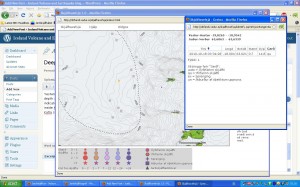
Picture of the earthquake as it appears on IMO web site in the “EWIS (Icelandic)” that IMO has. Currently this earthquake is not on the weekly reviewed charts.

This is not the only earthquake that has been happening in Katla volcano over the past few weeks.


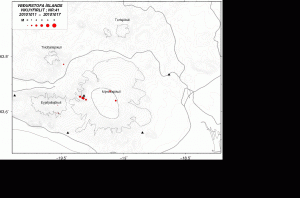
Week 41 earthquakes in Mýrdalsjökull and Eyjafjallajökull volcanoes.

The wait for Katla eruption is going to end one day. But that day is not today far as I know so far.

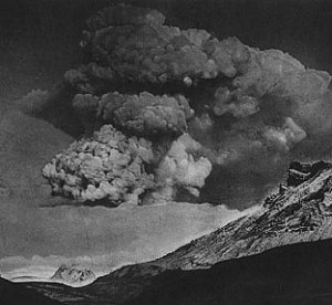
Two pictures of the 1918 eruption at Katla volcano

Here is a pictures of the 1918 eruption at Katla volcano.

This is not the most famous pictures of the 1918 eruption in Katla. But they do tell a lot of story what we can expect next time Katla erupts.

Here is what we can expect in terms of ice that is going to come down with the flood from next Katla eruption.

There are two people on top of the glacier ice-bergs. Gives a idea of the scales in question.

Pictures are from various sources on the internet.

Sudden rise in harmonic tremors around Katla and Eyjafjallajökull

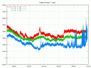
There is a sudden and sharp rise in harmonic tremors around Katla and Eyjafjallajökull volcano. I currently do not know what volcano is responsible for the spike in harmonic tremor. But this does not look like is a noise from the weather. But that can happen often this time of the year, as the wind forecast is good for all of Iceland at current time.

I will post more information if and when I get them.

SIL stations where the harmonic tremor rise can be seen.

Mið-Mörk
Eystri-Skógar
Lágur Hvolar (Currently most rise here for some reason)
Snæbýli
Saurbær
Ásmúli

Icelandic Met Office tremor web page.