Yesterday (18th October 2010) at 03:34 UTC there was a deep earthquake under Katla volcano. This earthquake was on a 14,8 km depth and had the size of ML0.7 according to reviewed earthquake data from IMO (this is too small for my Hekla geophone to detect at this distance). This was a single earthquake and does not indicate anything special at current time. However this earthquake might possibility signal a change inside Katla volcano and might be a start of a longer process that is in the end going to lead to a eruption in Katla some time in the future.
Currently it is unclear how the path to volcano eruption starts in Katla. But in 1918 there where no instruments to record that eruption.
This type of deep earthquake have sometimes created harmonic tremor signals in Katla volcano. But that happens due to dike event inside the volcano. This has happened regularly over the last few years. But has not been big enough to start a eruption.

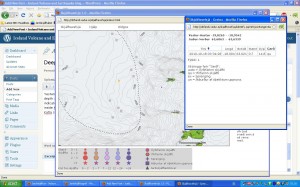
Picture of the earthquake as it appears on IMO web site in the “EWIS (Icelandic)” that IMO has. Currently this earthquake is not on the weekly reviewed charts.
This is not the only earthquake that has been happening in Katla volcano over the past few weeks.

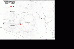
Week 41 earthquakes in Mýrdalsjökull and Eyjafjallajökull volcanoes.
The wait for Katla eruption is going to end one day. But that day is not today far as I know so far.

Jón: Little by little, their coming. This one was quite stronger, but only 5.6 km deep. What depths we should expect for a dike intrusion?
That’s not the same quake as this one huh.
Tuesday
19.10.2010 01:54:28 63.666 -19.178 5.1 km 2.0 90.02 4.6 km NE of Goðabunga
Weird activity on Tuesday:
19.10.2010 07:02:54 63.657 -19.259 0.1 km 0.4 99.0 1.9 km NNW of Goðabunga
19.10.2010 01:54:30 63.744 -19.303 21.3 km 0.5 90.01 11.5 km NE of Básar
19.10.2010 01:54:28 63.673 -19.143 3.3 km 1.3 99.0 6.5 km NE of Goðabunga
And also Monday:
18.10.2010 20:30:55 63.619 -19.469 1.1 km 1.6 90.01 6.5 km S of Básar
18.10.2010 18:49:37 63.641 -19.354 1.1 km 2.7 90.01 5.1 km W of Goðabunga
18.10.2010 11:05:31 63.606 -19.517 0.3 km 0.3 99.0 8.1 km SSW of Básar
Monday
18.10.2010 10:41:55 63.596 -19.496 1.1 km 0.8 99.0 7.3 km N of Skógar
18.10.2010 10:03:43 63.587 -19.390 10.7 km 1.1 99.0 8.1 km NE of Skógar
18.10.2010 03:34:28 63.621 -18.994 14.8 km 0.7 99.0 7.0 km NE of Hábunga
19.10.2010 09:34:06 63.637 -19,411 1.1 km 1.6 90.01 5.6 km SA af Básum
This one showed at Jón’s Helicorders.
I saw several quakes dots on KATLA posted on vedur but that doesnt tell me much.
WHERE is a link to the actual corders .. seismographs .. so I can see LIVE the magnitude and harmonics? I have been watching!
CJ
@Pastor CJ, There is no way to get that information from IMO. Besides there tremor plots. That is the only way to watch there seismographs online.
You can watch my helicorders here, http://earthquakes.jonfr.com
There are quite a few EQ´s at deeper levels these past days. Are they signs of intrusion or are they tectonic? Dont seem to be deep enough for tectonic or is it?
When it comes to see if the earthquakes are tectonic or not. I usually do so with the geology of the area in mind. Not all areas of Iceland have volcanoes but sometimes they also experience deep earthquakes.
But when it comes to volcanoes I look for earthquakes that are deeper then 5 to 10 km. But it is important to have in mind that sometimes deep tectonic earthquakes also happens close to volcanoes and it can be tricky to tell the difference when it comes to volcano earthquakes.
Currently it is the high season for Katla earthquakes. Even earthquakes that top ML3+ in size.
Does Katla tend to erupt at a specific time of the year, due to increased or decreased ice pressure?
Would be interesting to check that…
@Irpsit, Most common time of the year is September to November. But also from April to June. But that is just recorded history. Given the changes in the glacier over the past few decades now that pattern might be different now.
Irpsit, here are some relevant articles to your question. One of the articles theorizes that Myrda’s elliptical shape specifically increases the likelihood of a Katla event from seasonal ice deloading beyond the normal ice deloading effect. I copied the link, but didn’t review to see if this is the article I read months ago where it stated that the last 9 times Katla erupted was in the late summer months or thereafter.
http://onlinelibrary.wiley.com/doi/10.1111/j.1365-246X.2010.04603.x/abstract
http://rsta.royalsocietypublishing.org/content/368/1919/2519.full.pdf+html
continued movement on the gfum gps station
Jón: What is this new feature on Hekla’s webcam?
http://www.ruv.is/hekla
Looks as if there has been a landslide or something similar…
@Renato Rio, I can’t see anything due to a snowstorm or a fog in the area. But it sometimes happens before a eruption in Hekla that the surface gets warmer and enough to melt the snow. If that is the case now Hekla might get interesting soon. But it is hard to know when I have not seen this.
and what is that little lighthouse…. ?
km marker?………..Katla indicator? i missed the explanation
on the big board and was too embarassed to ask………..
i like Jon’s site……feels more homelike.
Best!motsfo
Looks like Grimsvotn GPS station is reporting again movement, not only upwards but also northwards. Tremor looks stable there. And not so many earthquakes yet.
@Irpsit and @renee
I guess we are seeing more ice build-up on the antenna of the GPS systems, as has happened a couple of weeks before (see Jón’s earlier posts and the discussions that abounded). Looks like this is the season of that kind of precipitation, leading to ice build-up.
Another grad student will have to trek out to the glacier and clean the ice off the antenna again….
@Renato I noticed that earlier also but even going full screen couldn’t decide what it was. I cannot even acces the Helka cam now
Has Hekla changed? 🙂
The landscape is different espcially on the left side of the picture
Jon sorry to use your blog to spread the message. It is currently impossible to post on the blog of Erik, do you or others are problems too?
Écouter
Lire phonétiquement
Dictionnaire – Afficher le dictionnairenom0.forgiveness0.pardoninterjection0.pardon0.sorry
It works without problems. The comment box is now before all the comments and not any more in the end.
Hmm. Interesting. It seems a very long and patient wait for something to happen at Katla! Is there any information available to us about what is happening around Katla and whether it is inflating or not?
I’m sure there will be an eruption sometime in the near future, maybe next spring?
I noticed the other day as well about Hekla. It seems there is definately a change in the slope, almost looks like a sand dune that sunk…lol Today was the first day I had to get a good look at it and was wondering the same thing.
@ Jón: What do you think about the earthquakes near Hvannadalshnjúkur?
Tuesday
19.10.2010 21:48:09 64.239 -16.542 3.6 km 1.9 90.01 25.7 km NNE of Hvannadalshnjúkur
Tuesday
19.10.2010 21:34:03 64.272 -16.882 9.2 km 1.3 37.08 23.9 km SE of Grímsfjall
Tuesday
19.10.2010 21:20:04 64.234 -16.524 1.6 km 1.7 86.8 25.5 km NNE of Hvannadalshnjúkur
Tuesday
19.10.2010 21:15:26 64.240 -16.537 1.9 km 2.0 85.71 25.9 km NNE of Hvannadalshnjúkur
Tuesday
19.10.2010 21:05:20 64.238 -16.497 0.7 km 2.3 82.37 26.3 km NNE of Hvannadalshnjúkur
Tuesday
19.10.2010 21:04:48 64.240 -16.528 2.4 km 1.8 90.02 26.0 km NNE of Hvannadalshnjúkur
…
@Diana, I am going to make a post about it shortly.
@ Jón: Thanks. 🙂
@Diana, The post is up and ready.
@ Jón: Great and thank’s a lot! 🙂
…. heres some helpful links…might have to copy and paste…good geonerdyvulcanshit…ps still learning
http://earthquake.usgs.gov/earthquakes/recenteqsww/
http://www.ruv.is/katla
http://www.iris.edu/seismon/
http://www.ruv.is/hekla
http://sohowww.nascom.nasa.gov/home.html
http://en.vedur.is/earthquakes-and-volcanism/reports-and-publications/
http://www.volcano.si.edu/reports/usgs/index.cfm
http://www.volcanolive.com/volcanocams.html
http://live.mila.is/eyjafjallajokull-fra-thorolfsfelli/ currently being upgraded…
http://www.vulcanoetna.com/en_etna_cam_3.php
http://cnt.rm.ingv.it/earthquakes_map.php
http://www.fournaise.info/webcam06.php
http://www.avo.alaska.edu/activity/index.php
http://feww.wordpress.com/2010-disaster-calendar-october/
http://hraun.vedur.is/ja/englishweb/tremor.html
http://icelandgeology.net/
http://www.simnet.is/jonfr500/earthquake/tremoren.htm
http://journal.borderlands.com/1997/infrasound/
http://vilda.alaska.edu/cdm4/results.php?
CISOOP1=exact&CISOFIELD1=CISOSEARCHALL&CISOROOT=all&CISOBOX1=Alaska+Earthquake%2C+Alaska%2C+1964
http://maryannmelton.blogspot.com/2009/01/yellowstones-earthquake-activity.html
http://vulcan.wr.usgs.gov/Volcanoes/DecadeVolcanoes/framework.html
last but not least….
http://www.youtube.com/watch?v=Zkox6niJ1Wc turn vol down…please.just sayin
Jon,
You have been referenced in WikiPedia, too! See: http://en.wikipedia.org/wiki/Katla
@Jack @ Finland, I did notice that. But the problem is that they wrongly interpreted what I was saying in that blog post.
I wonder if a doomsday looking people where editing that entrance on Wikipedia. But they hunt this blog a lot far as I can tell. They are best ignored in my opinion.
If you look for Katla on the Web or on Twitter, you will find references to your blog. I guess you have to be careful how to write stuff.
@Jon:
When you’re saying “soon” (in geologic terms), people familiar with geologic time scales will probably understand you correctly. But for those dooms-day & media people the word “soon” means a totally different time scale.
So, it is about understanding, and at the same time it is not about understanding.
See http://www.dlr.de/en/desktopdefault.aspx/tabid-1/117_read-27181/
In the article they claim, that they see the ice sheet over Katla melting!
In the world of doomsday merchants, the opinions of the non-erudite count as hard fact. This isn’t too far from what’s going on at universities around the world where in the words of professor C. Northcote Parkinson dim men elect dim men and it’s far more important to a) adhere to the paradigm, b) don’t show sparks of brilliance, intuition or independent thought, and c) write papers that mimic those of others, offer no new insights and include as many references as possible, preferably favourable ones of those currently in fashion and those who are to review your “work”.
Like Jón says best ignore, or send off with a flea in their ear.
As I said, “they claim…” ;o)
As Boris has already said at Eruptions blog, we inadvertently post all kinds of comments here for our “internal purposes” and often link them to some reference for the sake of illustration of the healthy discussions we undertake, but all of us here know they are read as “food” for the unwary readers.
Media guys are eager to sell newspapers, so they won’t have any scruples whatsoever to post them as being experts’ opinions.
We should be highly aware of that fact.
http://www.youtube.com/watch?v=SPaFr5kpeyA over time looks like stuff is happening over Katla
11 EQ’s at Katla in last 24 hrs. Mostly very shallow, however, a few lately have been little larger than usual on the NW rim. For the shallow ones, itl looks like a large chunk of ice shifted, especially when looking at the straight line of quakes.
I know the shallow ones under 5km related to ice shifting can continue into Nov, but I am not able to compare this years quakes to previous years so I don’t know if the normal summer ice melt is entirely the source of these shallow quakes or if there is a spike this year along with a spike in deeper quakes. I just don’t have the tools or knowledge to discern the difference.
Don’t know if you can answer this Jon.
Earlier today I was looking at this page:
http://notendur.hi.is/runa/eyja_gps.html
It had GPS data on Eyja/Katla up to the 30th October. That was this morning. Now it is 404’d
Up until an hour ot two ago I could still see two of the graphics off the page, but they have now gone as well.
I originally came across this link which was entitled “GPS mælingar Jarðvísindastofnunar Háskólans ” and is on the page: http://hraun.vedur.is/ja/Katla2009/
It still is on that page, but now it does not work.