Continued and strong earthquake activity north of Kolbeinsey Island

For the past few weeks something has been going on in the deep ocean far north of Kolbeinsey Island. The area north of Kolbeinsey Island has been having strong earthquake swarms for several weeks now, what is creating them is less clear.
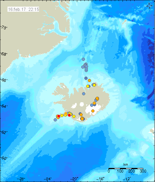

The earthquake activity north of Kolbeinsey Island (blue dots). Copyright of this image belongs to Icelandic Met Office.

All magnitudes are under-estimated at this location. I managed to record the last earthquake swarm (largest earthquakes) and it was clear by this activity that something was going on. Five earthquakes that where at least magnitude 3,2 (estimate) took place in the space of 4 – 8 minutes. This where only the earthquakes that I was able to record, distance from my geophone to this area is ~230 km at shortest distance. Making it difficult for me to record earthquakes on my simple geophone. Icelandic Met Office SIL network is not having much better luck recording earthquakes at this location, due to distance the SIL network underestimates the magnitude and location of the earthquakes has higher than normal error margins (up to several dozen of km at most).

There is a possibility that an eruption is taking place at this location now. There was a possible eruption or dyke injection at this location in October of the year 1999, the Global Volcanism Program report on that activity can be found here.

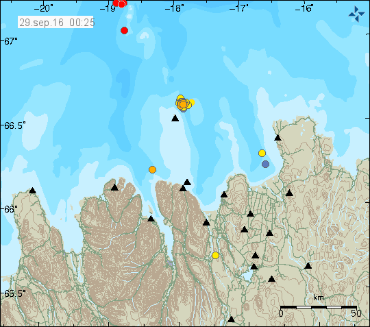
Overview of micro-earthquake activity in Iceland 28-September-2016

This is a short overview of the micro-earthquake activity in Iceland on 28-September-2016. Please note that some of this earthquake activity may have started some days ago and only got really busy on 28th September 2016.

Kolbeinsey Island / Ridge

Late on the 28-September-2016 an earthquake swarm took place in Kolbeinsey Island / Ridge. This is the largest earthquake swarm in this article. With the largest earthquakes having the magnitude above 3,0. Due to distance from the SIL network exact calculation of the magnitude and depth doesn’t appear to be possible. Last eruption taking place in Kolbeinsey Island / Ridge took place in the year 1755. No other eruptions have been documented since, but they might regardless have happened. The area is far from land and difficult to observe.

East of Grímsey Island (Tjörnes Fracture Zone)

Minor earthquake swarm has been taking place earth of Grímsey Island in a area that many suspect is a volcano (it is marked as such in the GVP database). The earthquake swarm in question does not appear to be a volcanic in origin. This appear to be a tectonic activity taking place, as the movement of TFZ is 20mm lateral movement/year (they fault slide each other 20mm/year) the rift movement is only 5mm/year (eastern part only). Image showing the movements can be found here (vedur.is).

160929_0025
Earthquake activity in Kolbeinsey Island and Tjörnes Fracture Zone. Copyright of this image belongs to Icelandic Met Office.

South Seismic Zone (SISZ)

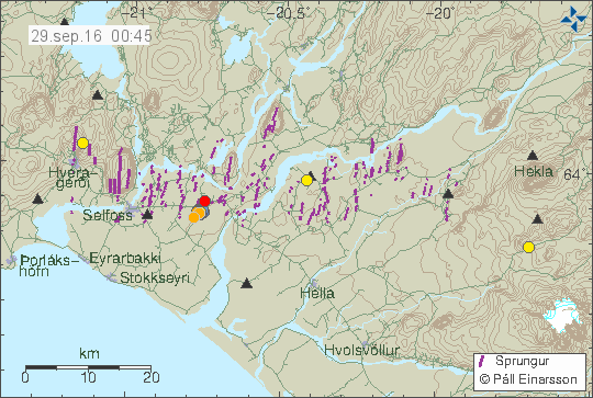
A small swarm of earthquakes has been taking place in SISZ this week. The largest earthquake in this swarm has only had the magnitude of 2,1. The activity is only minor and does not suggest a large earthquake is about to happen. This might be aftershocks of the earthquakes in 2000 or 2008.

160929_0045
The earthquake activity in SISZ. It’s only minor and west of Selfoss (red dot). Copyright of this image belongs to Icelandic Met Office.

Reykjanes peninsula

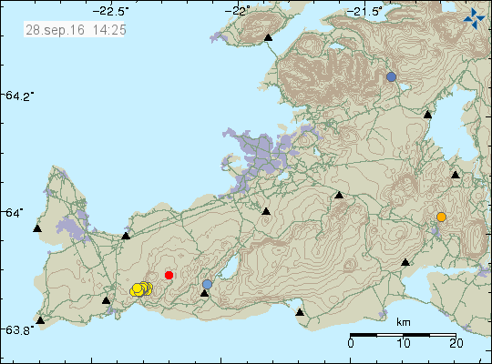
Earthquake swarm started on 28-September-2016 on the Reykjanes peninsula. This earthquake swarm was not strong and the largest earthquake in this swarm only had the magnitude of 2,1 and all other earthquakes where smaller in magnitude. Total of 60 earthquake happened when the swarm was active.

160928_1425
The earthquake swarm on the Reykjanes peninsula. It was not big in magnitude, but had a total of 60 earthquakes. Copyright of this image belongs to Icelandic Met Office.

Few earthquake have also been taking place around Iceland without any other activity. This type of one-off earthquake activity is common in Iceland. Why it happens is unclear.

Article updated at 02:03 UTC on 29-September-2016. Word corrections.

Earthquake swarm north of Kolbeinsey Island

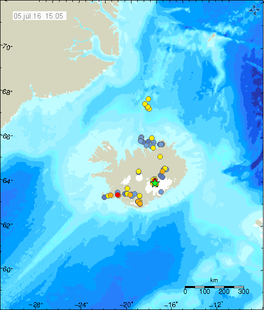
Today (05-July-2016) an earthquake swarm took place far north of Kolbeinsey Island. Earthquake activity in this area of the ocean has been increasing over the past few months. It’s unclear what is going on at the moment.

160705_1505
The earthquake activity north of Kolbeinsey Island. Copyright of this image belongs to Iceland Met Office.

Largest earthquakes in this swarm had the magnitude around 2,9 – 3,4. Good magnitude estimate is not possible due to the distance from the SIL network. What exactly is going on at this location is unclear. I do not rule out any eruption activity at this location when earthquake swarms take place. This might also just be normal earthquake swarm without any eruption connection. The depth of the ocean at this location is around 3 – 5 km.

Earthquake swarm ~125 km north of Kolbeinsey Island

Donations

Please remember to support my work with donations. My main job in this writing is to convert hard to read data about earthquakes or volcanoes into human readable format. It might not sound like a lot, but it can be a time consuming work to read all the data in their raw format (if I have to) and figure out (or try doing so) what is going on at times. Thanks for the support.

Kolbeinsey earthquake swarm

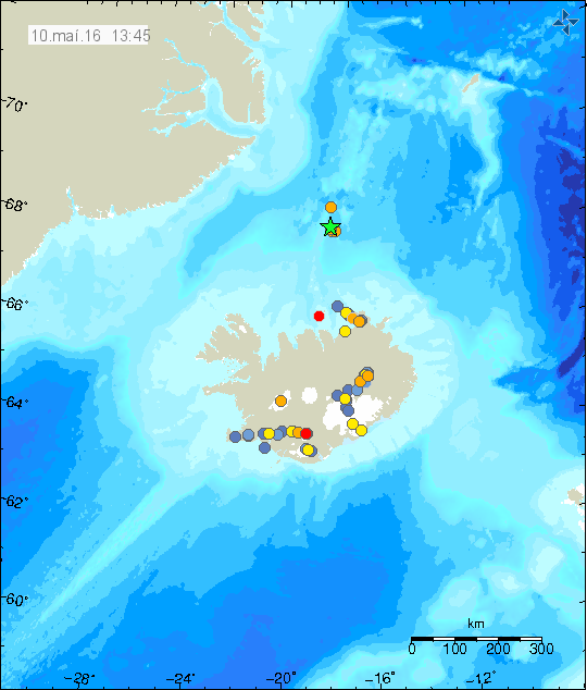
This earthquake swarm started sometimes yesterday (09-May-2016) or last night (10-May-2016), the first earthquakes appeared on SIL network at 01:03 UTC. This area north of Kolbeinsey Island is located around 125 km north of it. It is thought that this area had an eruption in the last few years (I can’t find the exact year), but it was not confirmed far as I know. Mostly due the location far from the coastline. It is difficult to know for sure what is exactly going on at this location. Activity has been going up in past few months in this area.

160510_1345
The earthquake area north of Kolbeinsey Island. It is around 125 north of Kolbeinsey Island. Copyright of this image belongs to Iceland Met Office.

This area is rather unknown, but some study has been done into it. I’m sure on the details. There is a possibility that activity is going to continue in this area for next few days. If an eruption takes place, nobody is going to notice it due to distance from nearest population center (~200 km).

Earthquakes north of Kolbeinsey Island

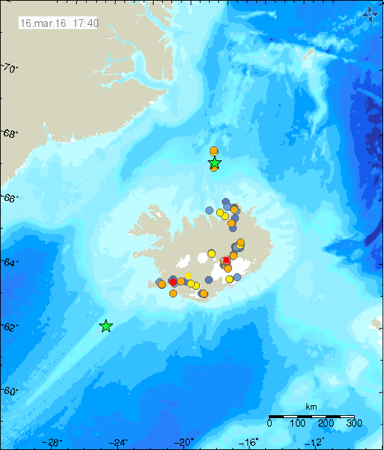
Today (16-March-2016) there was an earthquake swarm around 110 km north of Kolbeinsey Island. At this location there are no registered or known volcanoes, there however might be one, but it is difficult to confirm. This earthquake activity however appears to be related to an rift valley that is at this location, rather then any volcano activity.

160316_1740
The earthquake activity around 110 km north of Kolbeinsey Island. Green star shows the location of the largest earthquake. One magnitude 3,0 earthquake was deep on the Reykjanes Ridge (green star). Copyright of this image belongs to Iceland Met Office.

Largest earthquake in this swarm had the magnitude of 3,1. That magnitude is possibly an underestimate of magnitude due to distance from the SIL network. Other earthquakes have been smaller, but one earthquake had the magnitude of 2,9. That earthquake might have had a magnitude above 3,0 in reality. I suspect more earthquake activity has taken place without being detected by the SIL network.

Donations

Please remember to support my work with donations. Thanks for the support.

Earthquake swarm far north of Kolbeinsey Island

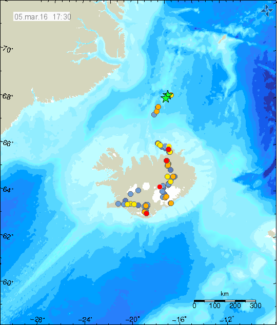
Today (5-March-2016) an earthquake swarm place took place around 190 km north of Kolbeinsey Island. Two largest earthquakes detected had the magnitude of 3,3. Other earthquakes where smaller in magnitude. Due to distance exact location is difficult to confirm, along with exact magnitude. This earthquake activity did not appear on EMSC seismic network.

160305_1730
Green stars show the location of this activity. Its only a best estimate by Icelandic Met Office. Copyright of this image belongs to Icelandic Met Office.

At this location there might be a volcano, it is unconfirmed at the moment. Last eruption is suspected to have taken place between 1997 or 1998. This volcano doesn’t have any name that I know of.

Minor earthquake swarm close to Kolbeinsey Island

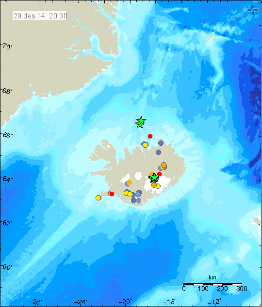
Yesterday (Sunday 28-Desember-2014) a minor earthquake swarm took place close to Kolbeinsey Island (part of Kolbeinsey ridge). Due to distance it is difficult to know how many earthquakes took place since only largest earthquakes are recorded by the SIL network.

141229_2030
The earthquake activity north of Iceland, both close and far from Kolbeinsey Island. Copyright of this image belongs to Icelandic Met Office.

The largest earthquake had the magnitude of 4,4. Second largest earthquake had the magnitude of 3,8 according to Icelandic Met Office. Few other earthquakes took place, they had smaller magnitude and have poor location due to distance from the SIL network. Since nearest SIL station is some 50 – 80 km distance from the location of the earthquake swarm.

Earthquake swarm in Hengill volcano

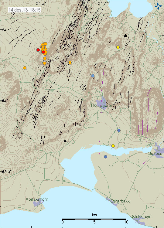
A earthquake swarm of minor earthquakes took place in Hengill volcano today. This earthquake swarm was due to Orkuveita Reykjavíkur was pumping down water in the area.

131214_1815
The earthquake swarm in Hengill volcano this evening. Copyright of this image belongs to Icelandic Meteorological Office.

The largest earthquake had the magnitude of 1,4. Other earthquakes were smaller.

Continued earthquake activity north of Kolbeinsey Island

During the week the earthquake activity continued north of Kolbeinsey Island. Two more earthquakes appeared, they had the magnitude of 3,0 and 3,1 according to EMSC. I do not have any image of that activity since I was travelling the days it was on Icelandic Meteorological Office website.

Webicorder images still do not update

Something failed in my hardware few days ago so no webicorder images are updating at the moment. I do not know what did go wrong or what did fail and it is going to be few weeks until I know why. According to electronic usage readings from my home something powered down or was powered down (I know what normal usage should be based on what electronics where turned on when I left). I am not sure what was turned off or did go offline and I won’t find out until I get back home. Until then my webicorder images are not going to be updated. International webicorders are updating (mostly) normal now and all large earthquake activity in the world is going to appear on that website. I do not run any of the images shown there so they are unaffected by this failure.

Donations

Like so many projects on the internet. I depend on donations to keep my working ongoing here. They allow me to work on this full time. Since I am not allowed to use the “Donate” button from Paypal. People have send me the donation directly via “Send Money” option on Paypal website. Thanks for the support.

Earthquake swarm activity north of Kolbeinsey island

Donation note: I want to thank people for the donations I have received over the year. But donations allow me to continue my work here and keep writing about volcano and earthquake activity in Iceland. If not for donations I would not be able to do anything. That includes writing on this website. So I am always thankful for donations. Since they allow me to continue my work here. Donations also allow me to maintain my geophone network in Iceland is expensive and last hardware updates was exactly that. So if you can donate, it is most welcomed. Information on how to donate can be found here. Thanks for the support.

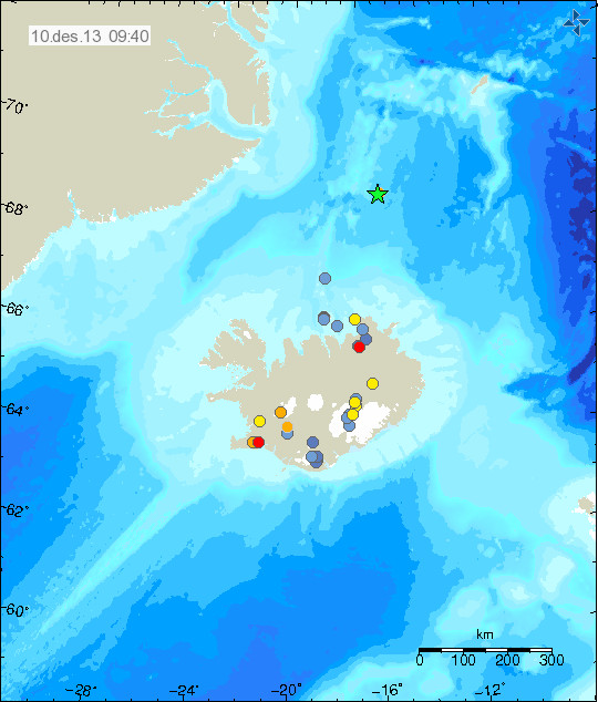
During the night a magnitude 4,1 earthquake was recorded around 240 km north of Kolbeinsey island. This is automatic location and magnitude. So it is subject to change.

131210_0940
Earthquake activity north of Kolbeinsey island (green star). Copyright of this image belongs to Icelandic Meteorological Office.

I don’t know yet if I detected it on my Böðvarshólars geophone (website here). Since I have not had the change to review the data from that geophone yet. I am not sure what is taking place at that location. This might be earthquake swarm activity before and eruption starts there, but due to remote location and ocean depth it is currently impossible to know for sure at this point.

Magnitude 3,4 earthquake 15 km north of Kolbeinsey island

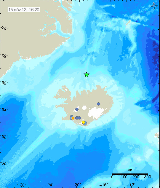
Today (15-November-2013) at 05:32 UTC an magnitude 3,4 earthquake took place 14,9 km north of Kolbeinsey island. The depth of this earthquake was 3,9 km according to Icelandic Meteorological Office. Due to distance from the SIL network the magnitude and depth might be underestimated.

131115_1620
The earthquake north of Kolbeinsey island is marked by the green star. Copyright of this image belongs to Icelandic Meteorological Office.

Due to distance from land it is difficult to know for sure what is happening at this location. So far no harmonic tremor has been detected so no eruption is taking place at this location. This earthquake did appear clearly on my geophone in Böðvarshólar. My geophone website can be found here.