Orange alert level declared for Bárðarbunga volcano

This is short update on Bárðarbunga volcano. Due to ever changing nature of this events this information is going to get outdated quickly.

Icelandic Met Office has moved the warning level for air traffic up to Orange level (see here). GPS measurement have confirmed magma movements inside Bárðarbunga volcano and this movement is fast.
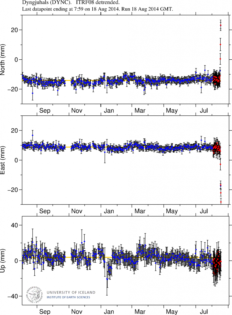
DYNC_rap.svd.18.08.2014.at.15.13.utc.raunvis.hi.is
GPS data from University of Iceland. This data shows how fast the change has been in the past few days. More GPS data can be found here. Copyright of this image belongs to University of Iceland.

Earthquake activity has remained about the same, with regular fluctuation in activity. Overall however the activity has remained constant.
140818_1440
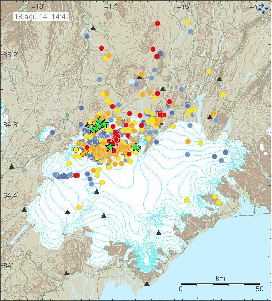
The earthquake activity in Bárðarbunga volcano. Copyright of this image belongs to Icelandic Met Office.

The earthquake activity in Bárðarbunga volcano has been migrating to the north-east over the past 10 to 18 hours. The activity close to Dyngjuháls appears to be stable at that location for the moment. Earthquake activity in other parts of Bárðarbunga have quieted down for the moment, that might change without warning.

140818_1440_trace
Earthquake activity has remained stable in Bárðarbunga volcano. Copyright of this image belongs to Icelandic Met Office.

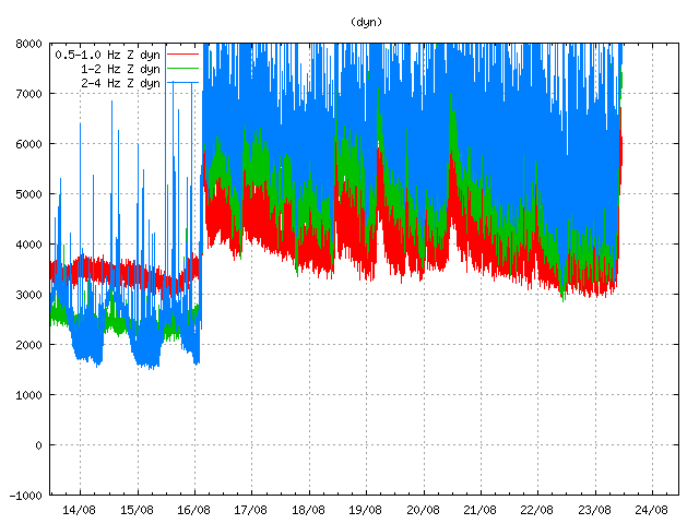
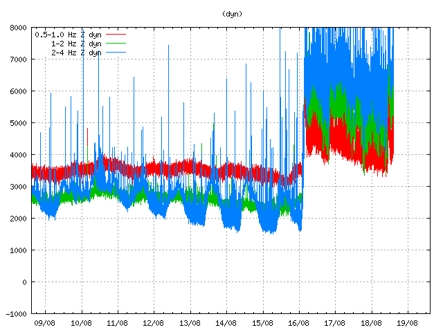
Harmonic tremor levels have remained stable since this started. They do drop a little in sync with the drop in earthquake activity.
dyn.svd.18.08.2014.at.14.46.utc
The harmonic tremor at Dyngjuháls SIL station. Copyright of this image belongs to Icelandic Met Office.
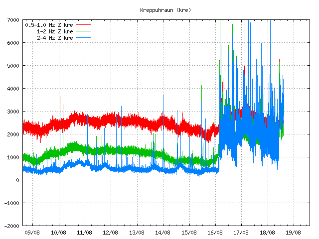
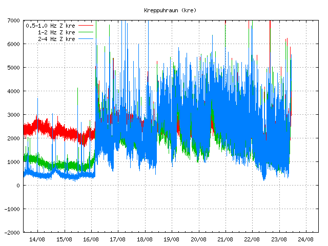
kre.svd.18.08.2014.at.14.47.utc
Kreppuhaun SIL station shows the harmonic tremor also. Along with interesting jump in the past hour of harmonic tremor activity. I am not sure why that is. Copyright of this image belongs to Icelandic Met Office.
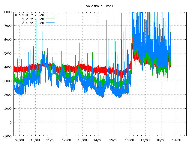
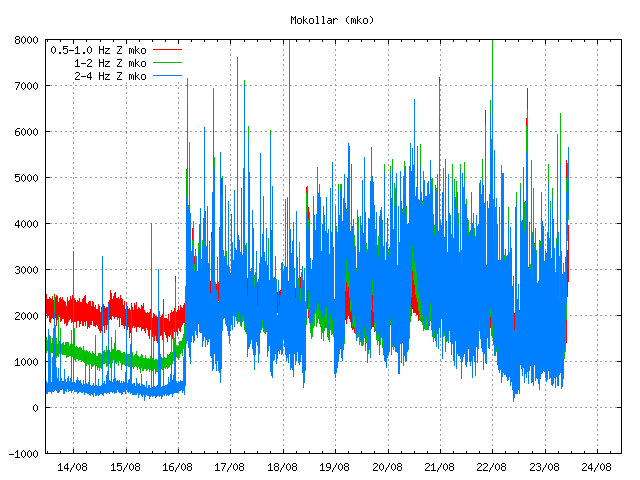
von.svd.18.08.2014.at.14.46.utc
Vonaskarð SIL stations shows pattern that is close to what appears on Kreppuhraun SIL station. Copyright of this image belongs to Icelandic Met Office.

I am not sure why the harmonic tremor levels are what they are at the moment. Since no eruption has started. This might be due to changes in hydro-thermal areas under the glacier, or there might be some other reason for this that is not known to me.
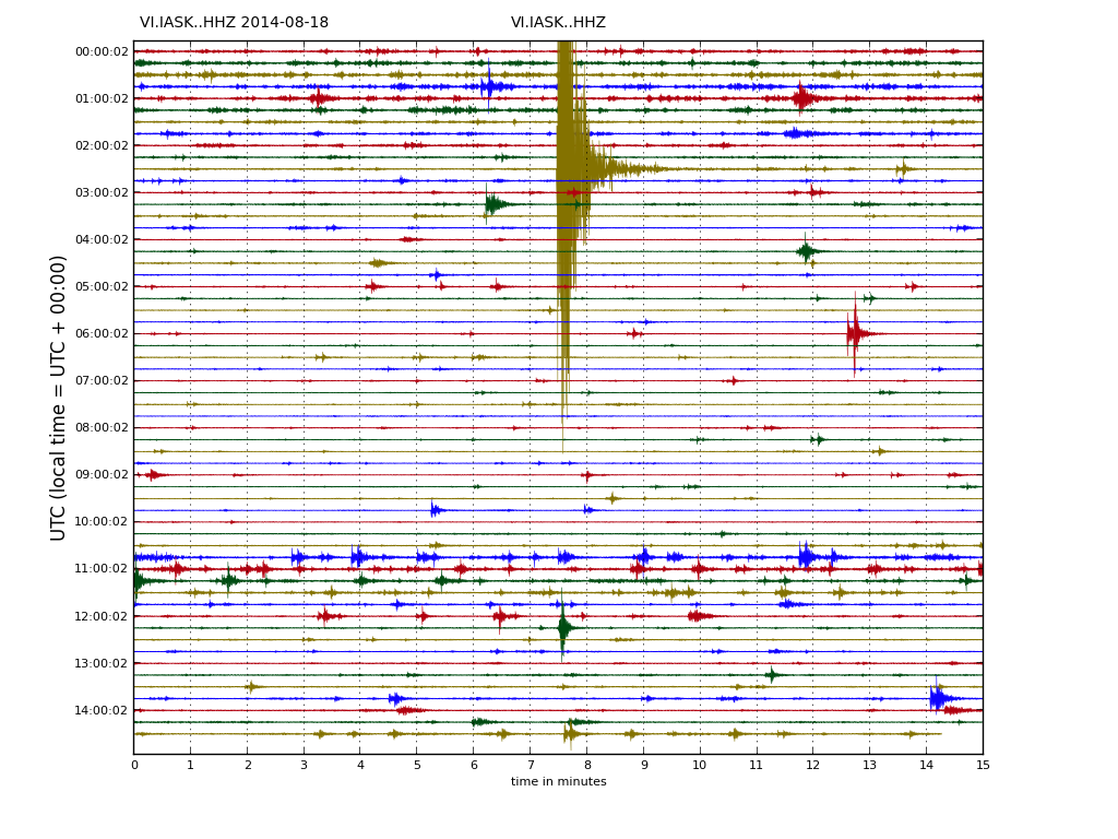
IASK.svd.18.08.2014.at.14.46.utc
Drum plot that Icelandic Met Office has on-line are showing interesting activity. Around 11:00 UTC there is a string of earthquakes, following this activity a increase in harmonic tremor takes place. Copyright of this image belongs to Icelandic Met Office.
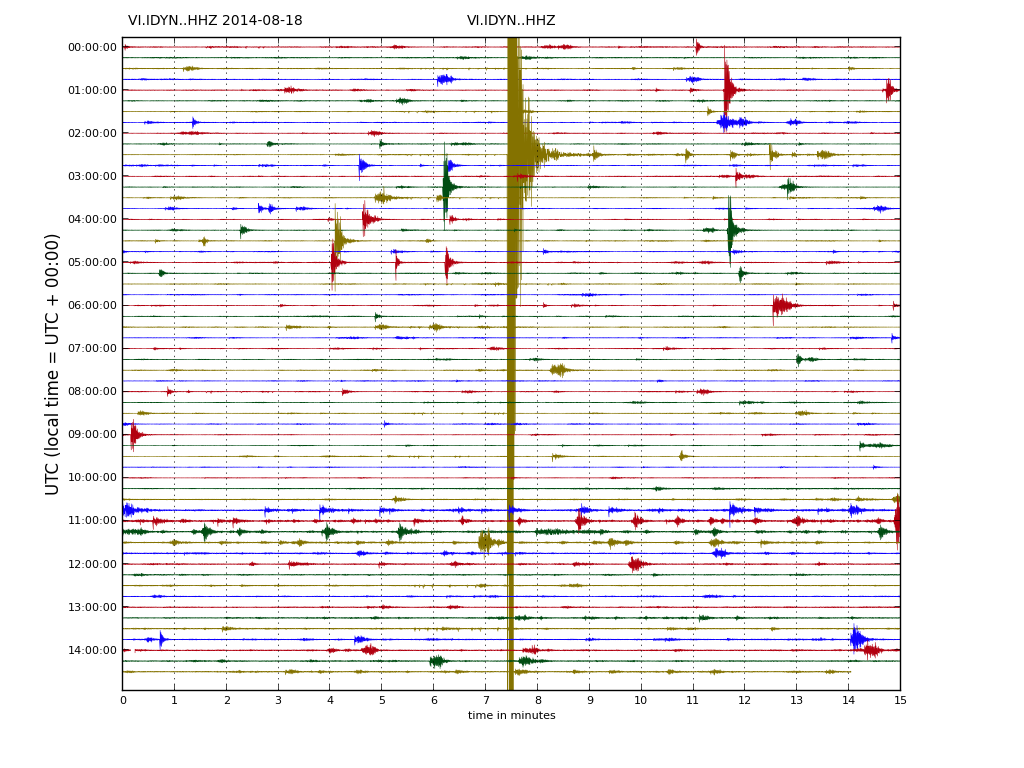
IDYN.svd.18.08.2014.at14.46.utc
This can also be seen on Dyngjuháls SIL station. Copyright of this image belongs to Icelandic Met Office.

IKRE.svd.18.08.2014.at.14.48.utc
This also appears clearly on Kreppuhraun SIL station. Copyright of this image belongs to Icelandic Met Office.

As for amount of earthquake detected today, so far the amount recorded today is around the same as yesterday, might even be slightly higher.

Updated at 16:43 UTC.

Short update Bárðarbunga volcano at 17:52 UTC

This is a short update on current status on Bárðarbunga volcano.

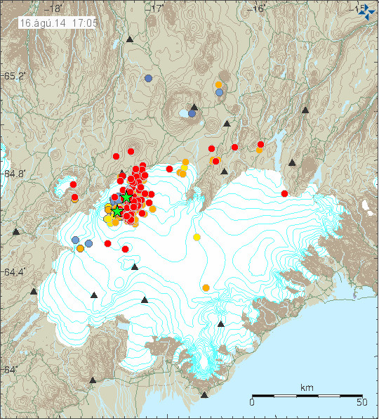
Uncertainty level has been declared on Bárðarbunga volcano and it status has been raised to yellow. There are fluxuation in earthquake activity, this is normal since earthquake activity in volcanoes is never close to constant in this type of situations. There is also a storm taking place in the area at the moment, that is lowering what is detected by the SIL stations that are close to Bárðarbunga volcano.

140816_1705
The earthquake activity in Bárðarbunga volcano. Green stars show earthquake larger than magnitude 3,0. Copyright of this image belongs to Icelandic Meteorological Office.

Largest earthquakes recorded so far have the magnitude of 3,1 and 3,5. There is a chance that more magnitude 3,0 have taken place but have not been reviewed yet by geologist at Icelandic Meteorological Office due the amount of earthquakes taking place at the moment.

140816_1710_trace
As can be seen here the earthquake swarm is dense. Copyright of this image belongs to Icelandic Meteorological Office.

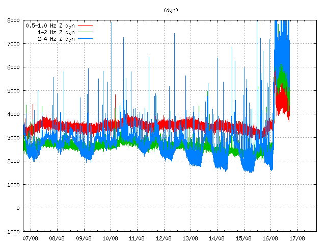
dyn.svd.16.08.2014.17.12.utc
Harmonic tremor in Dyngjuháls SIL station. It has been dropping in the past few hours. Copyright of this image belongs to Icelandic Meteorological Office.

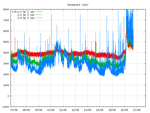
von.svd.16.08.2014.17.12.utc
Harmonic tremor in Vonarskarð SIL station. The drop in harmonic tremor also appears clearly here. Copyright of this image belongs to Icelandic Meteorological Office.

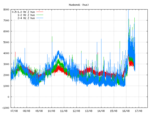
hus.svd.16.08.2014.17.13.utc
Harmonic tremor in Húsbóndi SIL station. The drop in harmonic tremor also appears here clearly. Copyright of this image belongs to Icelandic Meteorological Office.

In the past few hours the harmonic tremors around Bárðarbunga volcano have been dropping slowly. The drop in harmonic tremor has not been followed by drop in earthquake activity. At least that is not the case when this is written. This means that the magma that is on the move there still has not yet found a pathway to the surface, even if some small part of it has done so in possibly in one or two eruptions vents under the thick glacier. If the harmonic tremor stops completely without the earthquake activity stopping it means that magma is still on the move there and it might look for a new pathway to the surface. When and where that might happen is impossible to know at current time, but once the magma has clear path to the surface, even if it is under a glacier all earthquake activity is going to stop (for most part).

I am going to post more information when more details are available.

Unconfirmed eruption in Bárðarbunga volcano

This information is going to get outdated quickly as more information is collected on this activity.

During all last week (Week 33) there has been a minor earthquake swarm in Bárðarbunga volcano. No other activity followed this minor earthquake activity during the week until last night (16-August-2014). During the night (around 02:20 UTC) a harmonic tremor started to appear on SIL stations around Bárðarbunga volcano. Following the appearance of the harmonic tremor earthquake activity started around 03:30 UTC. Largest earthquakes in this swarm have magnitude around 3,0 so far. Depth is around 5 to 10 km. During the night the earthquake swarm moved around in the volcano and is now more east then it first started. According to Rúv news the glacier around this part of Vatnajökull glacier is around 700 meters thick, so it going to take a major eruption to break the ice. This however also means that when a glacier flood starts in this area there is a high risk that is going to be large.

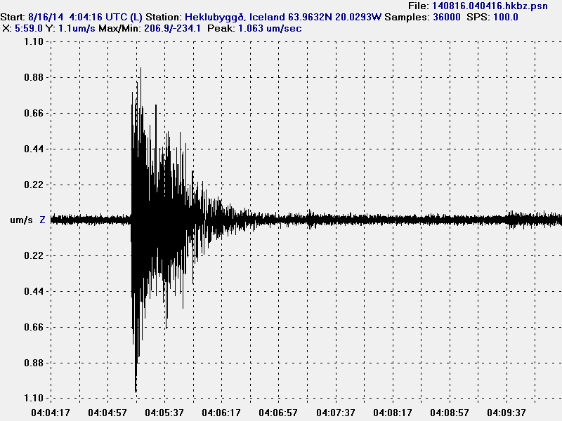
140816.040416.hkbz.psn
The largest earthquake that I did record during the night. This image is released under CC Licence. Please see CC Licence page for more details.

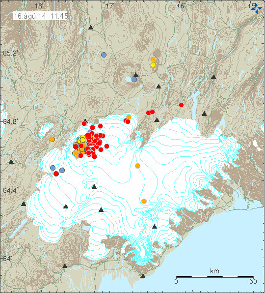
140816_1145
The earthquake swarm in Bárðarbunga volcano at 11:45 UTC. Copyright of this image belongs to Icelandic Meteorological Office.

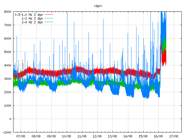
dyn.svd.16.08.2014.12.01.utc
Harmonic tremor on Dyngjuháls SIL station. This SIL stations is closest to the area of activity in Bárðarbunga volcano. Copyright of this image belongs to Icelandic Meteorological Office.

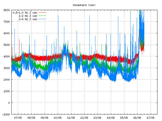
von.svd.16.08.2014.12.02.utc
Harmonic tremor on Vonaskarð SIL station. This is one of the SIL station that is closest to the area of activity in Bárðarbunga volcano. Copyright of this image belongs to Icelandic Meteorological Office.

Currently the activity in Bárðabunga volcano is not stable, it does fluctuate a little. Besides this minor fluctuation it seems stable. Based on harmonic tremor signal and its range this does not appear to be a large eruption so far. That might change without warning. I do however expect larger earthquakes before any major volcano eruption in Bárðarbunga volcano. What seems to have happened is that a dike intrusion got to the surface and started this eruption, even if it is just small one at current time.

I am going to post update soon as more information gets available. This situation is going to change quickly and without much warning.

New study finds signs of new eruptions deep on the Reykjanes Ridge

In the Icelandic news today there is a article about new study on the deep Reykjanes Ridge. According to that that study an eruption took place deep on the Reykjanes Ridge sometimes in the past 20 years. Following this eruption a sharp and strong earthquake activity took place at this same location. No signs of this eruption where visible on the surface of the ocean. At this location the depth is around 2 to 3 km. The unnamed volcano is at around the location at 61N degree north, this makes the location around 400 to 500 km from land. The study did compare scans of the ocean floor at this location taken in the year 1994 to new ones taken in the year 2013. This newer scans clearly showed that eruptions had taken place in the time period between those scans of the ocean floor. It is not known when this eruptions took place or how large they where, or for how long they lasted. There have been earthquakes swarms at this location in the past 20 years. I don’t know if that is a sign of new eruptions at this location. It is also extremely difficult to confirm any new eruptions at this location if such event took place after last scientific study into this area.

More information in Icelandic

Sjá merki um eld­gos á Reykja­nes­hryggn­um (mbl.is, map of volcano, Icelandic)
Áður óþekkt eldgos á Reykjaneshrygg (Rúv.is, Icelandic)

Updated at 14:48 UTC.
Updated at 15:09 UTC.
Updated at 15:11 UTC.

The rate of eruptions in Iceland

It is a common misconception that eruptions take place in Iceland every 4 to 5 years. That is the average number of years between eruptions. The actual picture of the eruption rate in Iceland is far from this simple. Eruption activity in Iceland happens in periods of 50 to 80 years. With long quiet periods between them that last up to 50 to 80 years. The period of high activity and low activity are about equally long according to scientific data. The longest period of quiet took place in the year 1720 to 1880, that is a quiet period of 160 years. The shortest period of quiet took place 1620 to 1720, this is a period of 100 years. The rate of eruptions during the active areas is 4 to 11 eruptions over a period of 40 years, but during the quiet period that number is 0 – 4 eruptions over a period of 40 years. In every case but one the eruptions where in Grímsfjall volcano.

Last peak in eruptions in Iceland took place in the years 1880 to 1900. Last eruption low took place in the year 1960 in Iceland. Before that this low in activity took place in the year 1820. The reason for this behaviour is that activity in the rift zone happens in jumps. It is not even activity with long quiet periods between them. [Speculation] If I use basic maths to figure out when next peak in activity is going to start, it puts it down in the year 2020. If that is going to happen is something that remains to be seen.

Reference material in Icelandic

Sigurður Steinþórsson. „Er eldvirkni á Íslandi sveiflukennd?“. Vísindavefurinn 19.7.2000. http://visindavefur.is/?id=672. (Skoðað 29.5.2014).

Donations: Please remember to donate to support my work. I don’t plan to use Google Adsense again. It is not worth the problems that it brings with it. If you buy something from Amazon via my banners (or this website) or my aStore (link here). I get 5 to 10% of the sale price as an advertisement fee (I don’t know the proper English for this, so this is going to have to do). Thanks for the support.

Rate of eruptions in Iceland

Donation note: I am currently working on a new solution for people to support my work and effort here. It is still possible to donate directly via Paypal by using my email address (jonfr@8930a1.talbot.shared.1984.is) if you have Paypal account. I have removed the subscription option since I hope to be able close down my Paypal account no later than on 1-Febuary-2014. As things are turning out I am not going to use Skrill.com and at the moment I do not have any account with them.

Update on donations: Since my other options have not worked out. I am going to keep Paypal as an way to get donations. As explained before I can not have the regular donation button due to requirement that Paypal has. There is nothing I can do about it since I do not want to risk loosing my Paypal account since I am going to be using it.

There is a common believe that eruptions in Iceland happens in Iceland every 3 to 5 years. According to this believe the next eruption in Iceland should take place around the year 2014 to 2016. The reality of this is far more complex than common believe is in this matters. It is true that eruptions are common in Iceland, but it is not the same to say that eruption happens at regular intervals. For instance the longest break in 20th century since proper documentation of eruptions started was 7 years (Krafla 1984 and then Hekla in 1991). Then there are shorter time periods between eruptions as happened in the year 2011 when no more than three eruptions took place in that year. Two minor ones and one large one. The minor eruptions took place in Grímsfjall volcano (largest eruption in 140 years) and smaller eruptions in Katla volcano (lasted for ~10 hours) and in Hamarinn volcano (~16 hours). Then we had a minor explosion (no eruption) in Kverkfjöll volcano during the summer of 2013 [coverage link on it here and here].

It is not uncommon in Iceland to have several eruption from several volcanoes at the same time or over few month period during the year. It has happened in the history of Iceland and can happen again. It is also not uncommon not to have any eruption in Iceland for a long time and quiet scene last for several years. Currently it is quiet in Iceland but the history has shown that it is not always so. For more details on eruptions in Iceland I reccomend this blog post (jonfr.com) and this overview from Icelandic Meteorological Office.

Blog post updated at 22:10 UTC.
Blog post updated on 10-November-2013 at 23:40 UTC.

More volcano ash in the ash cloud from Eyjafjallajökull volcano according to a new study

According to an new study into the Eyjafjallajökull volcano ash cloud. It appears that more volcano ash was up in the air then originally estimated. The estimation now is that the amount of volcano ash was around 100 times more then expected during the eruption. This has serious implications to air travel in the future if there is a repeat of the Eyjafjallajökull volcano eruption scenario. But most of Eyjafjallajökull volcano ash was small and fine volcano ash that did stay long time up in the air.

This is the conclusion in a study that was made by Mark Woodhouse (and more people) and is published in Journal of Geophysical Research. Sadly I do not have access to this study (I am too poor to do so). So I an only repeat what the Rúv News is saying about this study.

News and links

Öskufallið var meira en við héldum (Rúv.is, Icelandic)
Journal of Geophysical Research

Katla volcano eruption in the year 1918

Last large eruption in Katla volcano was in the year 1918. Cameras where a bit hard to find during this time and it took long time to take pictures of eruptions in those days. There are few pictures that exist today of the eruption in the year 1918 and the aftermath that did follow it.

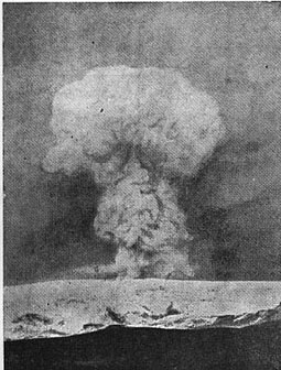
Here are the only pictures of the eruption taking place in Katla volcano during the year 1918.


The ash cloud from Katla volcano during the eruption in the year 1918.Author of this picture is unknown. Picture is assumed in public domain due to age (94 years ago). Death of author is unknown to me. Corrections welcomed.


Ice bergs from the glacier flood that did follow the eruption in Katla volcano during the year 1918. Author of this picture is unknown. Picture is assumed in public domain due to age (94 years ago). Death of author is unknown to me. Corrections welcomed.


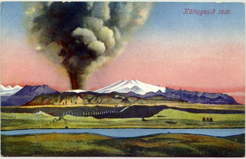
Painting showing the ash cloud of the Katla volcano eruption in the year 1918. I sadly do not know how did paint this picture or it’s copyright status. Corrections welcomed.

Based on this pictures. This is what we should expect from Katla volcano in the next big eruption. I do not know when that might be. It might be a long wait.

Harmonic tremor event in Hamarinn volcano

Tonight there was an small harmonic tremor event in Hamarinn volcano (Loki-Fögrufjöll, Bárðarbunga). This event was not big. But did appear on the Skrokkalda SIL station and on Grímsfjall SIL station. The pattern that is now appearing is the same one that did appear in July 2011 in the minor eruption in Hamarinn volcano. But that event took place week after Katla volcano minor eruption.


The harmonic tremor pulse on Skrokkalda SIL station. This is most likey from Hamarinn volcano. Copyright of this picture belongs to Iceland Meteorological Office.


The harmonic tremor pulse on Grímsfjall SIL station. This is most likey from Hamarinn volcano. Copyright of this picture belongs to Iceland Meteorological Office.

What gives clues that this Hamarinn volcano is that few days ago it had minor earthquake activity. But this area does not seem to need a lot of earthquake activity before a minor eruption takes place. Why that is I have no idea at present time.

I am going to update this blog post as event progress.

Scary news about eruptions in Iceland in The Telegraph

The newspaper The Telegraph has scary news about volcanism in Iceland. They have scary claims like this one here.

[…]

Katla’s eruption in 1918 produced five times as much ash as the 2010 Eyjafjallajökull one. A major eruption could result in large parts of Iceland being flooded as snow and ice melted; significant poisoning of Icelandic agriculture; destruction of property; and, of course, the grounding of aircraft across Europe.

[…]

Well, the Katla volcano has many different types of eruption. For instance, the July 2011 eruption in Katla volcano was small. There is no way to know what happens until a eruption starts in Katla volcano. When ever that might. As for “large part of Iceland being flooded”, this is just rubbish and bad reporting. Less then 1% of Iceland would get flooded in the case of eruption in Katla volcano. What area exactly depends on where the eruption takes place under the glacier. The largest area that can get flooded if the glacier if the flood goes down Þórsmörk and close to the area east of the village of Hvolsvöllur. Eruption in Katla volcano is going to destroy roads, bridges and other things in its path. But that is to be expected. In fact, Icelanders living in the area well aware of what a eruption in Katla volcano means to them.

[…]

If enough material is ejected it could even have a cooling effect on the global climate for a few years. A precedent for that would be the 1783-84 eruption from the fissure of Laki, which is part of the same volcanic system, Grímsvötn, that erupted last year. This was a very large eruption of 15 cubic kilometres (3.6 cubic miles), compared to the fraction of a cubic kilometre ejected in 2010, and had a huge impact on the northern hemisphere, reducing temperatures by up to 3 C.

[…]

Well, no. The reason is that Katla volcano is unable to make that large eruptions most of the time. The largest eruption that is known is the Eldgjá fissure eruption in Katla volcano that took place sometimes around the year 934. As for cooling it is worth noticing that Mount Tambora eruption that was VEI=7 in the year 1815. But it only did drop the temperature around 0.4 to 0.7C (called Year Without Summer). A temperature drop of 3C would create glaciers in Europe all year round. Even Laki eruption in the year in 1783 did not cool the northern hemisphere down to 3C. That amount of drop in temperature would equal a new ice-age in Iceland, Europe and North-America.

The last eruption in Grímsfjall volcano (May, year 2011) did not have this effects. But was at least VEI=4 in size. But that eruption was many times larger then the eruption in Eyjafjallajökull volcano in the year 2010. So facts do not support the claim this news from The Telegraph is making.

This claims, among others in this types of news is nothing but fear mongering news. It is meant to scare people. Why, it is my guess that it about news paper sales.

Scary News from The Telegraph

Iceland volcano: and you thought the last eruption was bad…