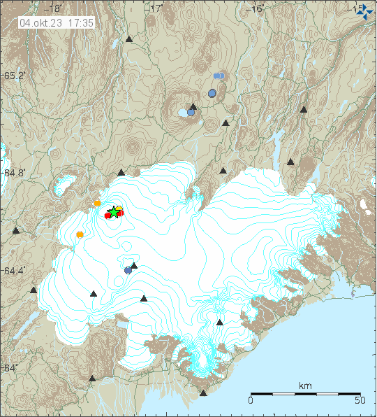
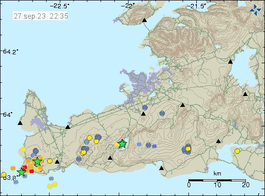
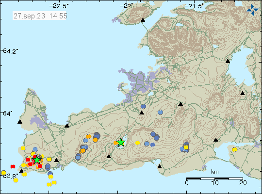
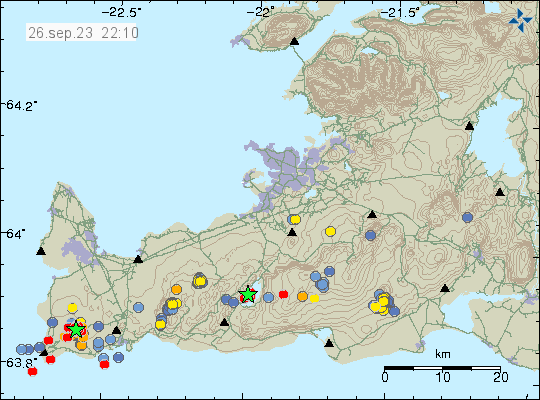
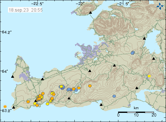
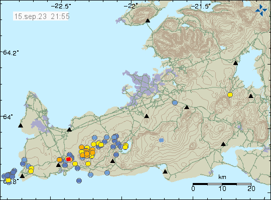
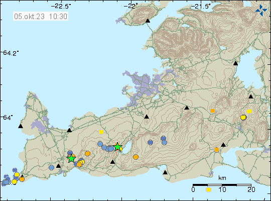
Icelandic Met Office reported that inflation has been detected in Torfajökull volcano. This inflation started around middle of June. The inflation has now reached around 40mm.
The inflation of Torfajökull volcano. Copyright of this image belongs to Icelandic Met Office.
How fast this is going to evolve is difficult to know since last eruption took place in 1477 and that was probably an eruption as a result of magma injection from Bárðarbunga volcano. Last eruption in Torfajökull volcano it self might have happened last in the year 1170. Eruptions in Torfajökull volcano are almost always explosive eruptions with an dangerous ash cloud that drifts under the direction of wind.
Yesterday (13. August 2023) an large earthquake swarm took place close to Geirfugladrangur (small rock island, population birds) on the Reykjanes ridge. The largest earthquake had a magnitude of Mw4,5 and was felt to Akranes town and possibly in other nearby towns on Reykjanes peninsula. There where not many reports about this earthquake being felt. Something above 400 earthquakes took place during the most active phase of this earthquake swarm.
Earthquake activity on the Reykjanes ridge. Copyright of this image belongs to Icelandic Met Office.
This earthquake swarm seems to be ongoing. It is at the moment, at much slower rate than before. There are clues that suggest this might have been a earthquake activity connected to magma movements in this area. Its difficult to be sure, because this area is under the ocean and measuring what is going on gets more difficult as future away from land activity happens. Eruption at this distance is going to appear on the Icelandic Met Office SIL network.
This is a short article about Askja volcano. Because I am getting information that are in my view slightly conflicting with each other.
It seems that an there has been a increase in gas and hydrothermal activity in Askja volcano and in nearby area because of inflation that is currently taking place. At the writing of this article the inflation in Askja volcano seems to have reached between 80mm to 100mm. The reports have been slightly difficult to place in a good picture of what is happening. That’s why I am limiting coverage about this until it becomes more clear to me what is going on.
The general advice from Icelandic Met Office is that people should not hike around Askja volcano or nearby area because of risk of gas and sudden eruption. There is no special earthquake activity at the moment and that makes it difficult to know what is going on. This might change without warning, as is sometimes the case with volcanoes.
Yesterday (12. August 2023) an small earthquake swarm took place in Hofsjökull volcano. Largest earthquake had a magnitude of Mw3,0 and the second largest earthquake had a magnitude of Mw2,5. The area is remote and there are no reports of this earthquakes being felt.
Earthquake activity in Hofsjökull volcano. Copyright of this image belongs to Icelandic Met Office.
According to Morgunblaðið news there where report of smelling gas after this earthquake activity. There is a risk of gas pockets around Hofsjökull volcano, probably mostly to the north in the area closest to the earthquake area.
I don’t have any other information about Hofsjökull volcano. Because it last erupted more than 12.000 years ago. At most there might have been smaller eruptions that resulted in lava flows sometimes in the last 12.000 years. I don’t expect an eruption now, this earthquake activity might signal a long term change in Hofsjökull volcano. How long that is going to be is anyone guess. It might be in the next 100 to 500 years or maybe never. Hofsjökull volcano is on its own rift zone that is slowly dying off. Along with Kerlingafjöll volcano to the south of Hofsjökull volcano. This are the only two (?) active volcanoes on this old dying rift zone (its around 5 to 10 million years old).
Today (30. July 2023) an earthquake swarm took place in Torfajökull volcano. This volcano is located north of Katla volcano (Mýrdalsjökull glacier). This area has had regular earthquake swarms over the year. Why is not clear. There is no clear signal of magma movement in this area. Torfajökull erupts highly Felsic magma that’s mostly explosive and some type of magma that can flow as a lava flow (maybe in later stage of an eruption, I don’t know for sure).
Earthquake activity in Torfajökull volcano. Copyright of this image belongs to Icelandic Met Office.
The largest earthquake in this swarm had a magnitude of Mw3,2. It was felt in nearby tourist areas and caused few rock slides. Icelandic Met Office is still warning against rock slides because of this earthquakes close to the earthquake swarm location. There is a ongoing risk of more stronger earthquakes in this area of the volcano at the writing of this article.
Rúv News and Earth Science at University of Iceland is reporting that the eruption in Fagradalsfjall at Litli-Hrútur might end in one or two weeks time. This is based on how much the lava flow from the crater is currently decreasing. This would also be mostly in line with the eruption in Meradalir valley in 2021, that lasted for two weeks. This eruption has been slightly longer than that eruption, since it has been slightly larger in volume of magma erupting.
Yesterday (28. July 2023) at 23:42 UTC and 23:55 UTC two earthquakes with magnitude of Mw3,2 and Mw3,6 took place in Bárðarbunga volcano. EMSC is reporting the earthquake at 23:55 as Mw4,7 and that information can be found here.
Earthquake activity in Bárðarbunga volcano. Copyright of this image belongs to Icelandic Met Office.
There where few smaller earthquakes following this larger earthquakes. This is normal inflation activity in Bárðarbunga volcano and this is going to continue for next 30 to 70 years (based on earlier history).
Yesterday (23. July 2023) at 23:17 UTC an earthquake with magnitude of Mw3,5 took place in Katla volcano. This earthquake was felt to Hvolsvellir town in south Iceland.
Earthquake in Katla volcano. Copyright of this image belongs to Icelandic Met Office.
No other earthquake or activity took place following this earthquake. Katla volcano remains quiet at the writing of this article.
This is a short update. Since there is not a lot of information about this.
The crater might collapse at any time without warning. Geologists that monitor the eruption have noticed that the crater has started to get larger and is now full of lava. This means it is going to collapse. What direction is not known. It is my view that it is going to collapse to the east because of least resistance in that direction.
When the crater collapses the lava is going to flow more than 100m/s in whatever direction it flows.
Tourists are in high danger close the crater because of this collapse risk.
Dyke intrusion has been detected east of Keilir mountain. Along with increased ground temperature, that means the magma is at shallow depth in the crust. This area might erupt soon in similar way as is now happening close to Litli-Hrútur.
This is all the information I have now and only thing that has changed in the eruption in the last 13 days.
This article is short. The eruption is mostly stable at the writing of this article but the situation can change quickly without warning.
The eruption has changed in last few hours. It seems to be in only one crater that is slowly forming. The eruption has stopped at the north most end of the eruption fissure. At the writing of this article.
The dyke now extends 1 km under Keilir mountain in the direction of north-east. This might be a new dyke intrusion and not connected to the dyke that started the current eruption. This might result in a second eruption soon, but its too early to know for sure at the writing of this article.
The eruption started large fires in the moss and other plants in this area around Litli-Hrútur. This has resulted in massive toxic smoke in this area.
There’s a high risk of the volcano gas from the eruption, along with the toxic smoke from all the plants and moss burning.
Interestingly, while earthquake activity has dropped it has not stopped. Why that has happened is a bit of a mystery, it might be connected to the possible new dyke that has formed under Keilir mountain.
Yesterday (10. July 2023) the longest the fissure extent was at 1500 meters or 1,5 km. Since then it has gone down to one erupting crater that seems to be 50 meters to 100 meters long.
Map of the danger area around the eruption. The orange area is the danger zone that people should not travel over. Copyright of this image belongs to Icelandic Met Office and others.
It is impossible to know how long this eruption is going to last. Since dyke intrusions are poor magma containers this eruption might be a short one if there isn’t a constant supply of fresh magma from the deep mantle. Its too early to know if that is the case here. I have also noticed that once the eruption ends in any area, that area is not going to erupt again. When the eruption ends, it ends forever and that makes this a single eruption activity or crater rows. This area might be Monogenetic volcanic field (Wikipedia).
Since this type of eruptions are mostly uneventful and just continue. I plan on only posting updates when there are some news or changes to the eruption happen.
Update at 17:41 UTC
ISOR is reporting that their station called FAF (Fagradalsfjall) has to be moved because the lava is flowing directly at it. They are going to find a new location for this station. This report can be seen here on Facebook in Icelandic.
Cookie acceptance
We use cookies on our website to give you the most relevant experience by remembering your preferences and repeat visits. By clicking “Accept”, you consent to the use of ALL the cookies.
This website uses cookies to improve your experience while you navigate through the website. Out of these cookies, the cookies that are categorized as necessary are stored on your browser as they are essential for the working of basic functionalities of the website. We also use third-party cookies that help us analyze and understand how you use this website. These cookies will be stored in your browser only with your consent. You also have the option to opt-out of these cookies. But opting out of some of these cookies may have an effect on your browsing experience.
Necessary cookies are absolutely essential for the website to function properly. This category only includes cookies that ensures basic functionalities and security features of the website. These cookies do not store any personal information.
Functional cookies help to perform certain functionalities like sharing the content of the website on social media platforms, collect feedbacks, and other third-party features.
Performance cookies are used to understand and analyze the key performance indexes of the website which helps in delivering a better user experience for the visitors.
Analytical cookies are used to understand how visitors interact with the website. These cookies help provide information on metrics the number of visitors, bounce rate, traffic source, etc.
Advertisement cookies are used to provide visitors with relevant ads and marketing campaigns. These cookies track visitors across websites and collect information to provide customized ads.