What is going on in Bárðarbunga volcano – basic analyse

This the first analyse article that I’m going to write. It is going to a short one and not written over few days, as is the plan to have them in the future. The reason for this is that this information might get outdated quickly as things change in Bárðarbunga volcano. This is going to be broken down into few parts for clarity (if possible).

Current activity in Bárðarbunga volcano

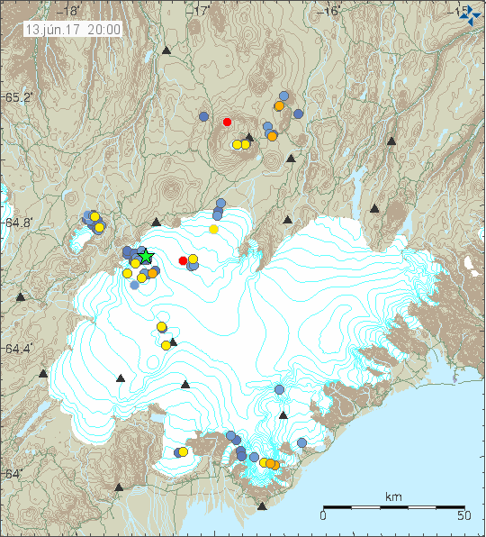
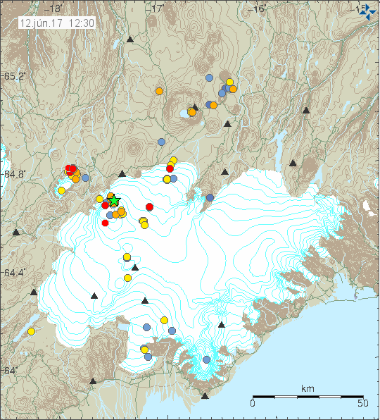
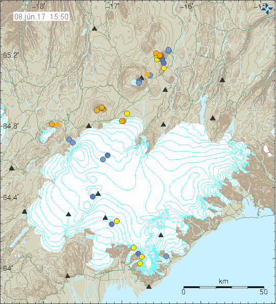
Bárðarbunga volcano is preparing for a new eruption and has been doing so since March-2015, few days after the eruption ended in Holuhraun. Where this eruption is going to take place is impossible to know fore sure, but there are clues to what might happen (it doesn’t mean it is going to). Current earthquake activity pattern suggests that the next eruption is going to take place directly south of Bárðarbunga volcano, slightly south of the Holuhraun dyke formation. At that location there is a dyke formation that has been building up for the last few years and in recent months I’ve noticed a slight increase in activity around that dyke, it has been making branches from it self, creating small earthquakes swarms in the process. I don’t know how large this dyke is, but what is clear from earthquake data is that it is deep, goes down to at least 25 km depth, maybe deeper.

160525_1715
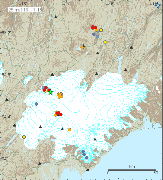
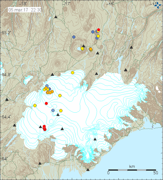
The cluster of orange dots is the dyke showing it self earlier today. Copyright of this image belongs to Iceland Met Office.

Since the activity started in Bárðarbunga volcano, this dyke has changed and appears to have started growing at some point (I don’t know when). Current size suggest that it is already large and contains large amount of magma. Amount is hard to estimate, but pure guess (short of educated) suggests that the amount of magma in this one dyke is already high and more might be at depth (25+ km depth). This one dyke has existed, or formed around 2005 – 2008 at earliest, it might have formed a good while ago, but this are the years I first saw it in the earthquake data. It is all over thick glacier (200 meters or more), so any eruption at that location would result in a glacier flood.

Eruptions risk at the moment

Currently Bárðarbunga volcano is in what I call “Active phase – not erupting”, meaning the volcano is not dormant (no activity at all). The risk of an eruption at the moment is in my view around moderate, nothing suggest that it is at high levels. That however is changing with each passing day and it is my view that one day there is going to be a earthquake swarm and activity that is going to start a new eruption in Bárðarbunga volcano and there is a good chance that eruption is going to take place under the glacier.

The caldera cauldrons (on the rim)

When the earthquake activity, connected with the dyke intrusion started in August-2014 and few eruptions under the glacier, few cauldrons formed in the glacier. Over the past few months those cauldrons have been getting larger and deeper, the glacier they are melting is up to 200 meters thick in this area (far as I know). The reason for this cauldron formation is the collapse (called slow collapse) of the Bárðarbunga volcano in 2014 – 2015 eruption. This suggests that magma has found a pathway to the shallow crust (5> km), but does not have the energy to start an eruption at the moment. This magma might never erupt at all, it might only create new hydrothermal areas in Bárðarbunga volcano. Paper on the collapse of Bárðarbunga volcano caldera can be found here, I don’t know how accurate or if this has been peer-reviewed article.

Earthquake depths

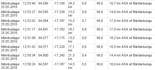
When something happens in Bárðarbunga volcano, like a strong earthquake swarm with magnitude 3,0 or larger earthquake taking place it sometimes has a activity taking place several hours before it. Here is how to spot it if it happens, it does not always take place for random reasons.

bardarbunga.earthquake.23.05.2016
Small earthquake in Bárðarbunga volcano, but notice the depth of 26,8 km. Screen-shot from Iceland Met Office website.

Depth is an important factor here, this earthquake took place at 26,8 km depth, suggesting that magma created it. That is not always the case, but it appears that this time it was. Since 12 hours later a magnitude 3,4 earthquake took place, meaning the pressure inside Bárðarbunga volcano changed (as I understand how this works).

bardarbunga.earthquake.25.05.2016.b
The dyke earthquake swarm. All magnitudes are small, but depth is the interesting part. Screen-shot from Iceland Met Office website.

The dyke earthquake swarm has different pattern. As the magma pushes up the dyke from deep it creates earthquakes along the weak points in its structure, making the depth appear at random as earthquakes are formed. This also expands the dyke a little, low amount of earthquakes indicates that there is not much of a resistance in the dyke where it is expanding at the moment.

Donations

Please remember to support my work so I don’t have to worry about bills and other money connected issues so much. Thanks for the support. 🙂

Magnitude 4,4 earthquake in Bárðarbunga volcano

Today (20-May-2016) a magnitude 4,4 earthquake took place in Bárðarbunga volcano. This is the strongest earthquake so far since the end of the eruption in February-2015. This earthquake swarm also had two magnitude 3,3 earthquakes. Other earthquakes where smaller in magnitude.

160520_1300
The earthquake activity in Bárðarbunga volcano. Copyright of this image belongs to Iceland Met Office.

Official statement from Iceland Met Office is that they are not sure what is going on. What is clear is that seismic energy being released from Bárðarbunga volcano has increased a lot since end of the eruption in February-2015 and current GPS data suggest rapid inflation. Both of are unusual after caldera collapse like Bárðarbunga volcano experienced in the 2014 – 2015 eruption. Due to lack of historical data it is hard to know for sure what is going on, whatever it is, it’s the first ever that is being monitored in great details.

Current events have not lead to an eruption so far. They however might do so in the future, when is difficult to know since the time frame of this development is unknown, it might be hours, it might be decades. Satellite images also show that cauldrons that have formed at the edge of the caldera are getting deeper and possibly larger, suggesting an increased hydrothermal energy at the locations where they have formed. This suggest that more magma is collecting at depth in the caldera, something as sad above is highly unusual due the recent caldera collapse in the last eruption. I’m expecting more earthquake swarms like this and growing magnitude of the earthquakes that take place. The weekly pattern is going to continue and I suspect it might increase soon, when is impossible to know for sure.

Donations

Please remember to support my work with donations (or by using Amazon). Currently my financial status is not so good (worse then what I was expecting). It will get better, just takes few months and I need to survive those months. Thanks for the help. 🙂

Magnitude 4,2 earthquake in Bárðarbunga volcano

Shortly after midnight of 8-April-2016 a magnitude 4,2 earthquake took place in Bárðarbunga volcano. This earthquake activity was shallow, most depth was around 3 to 5 km. Few earthquakes took place at 7 to 11 km depth, suggesting a magma movement at depth. Nothing suggest that magma reached shallow depth this time around.

160408_1240
The earthquake activity in Bárðarbunga volcano. Copyright of this image belongs to Iceland Met Office.

The second largest earthquake in this activity had the magnitude of 3,5 at the depth of 4,3 km. Other earthquakes in this swarm where smaller in magnitude at different depths. Magma did not reach the surface in this earthquake swarm, this appears to have been a movement of fault lines do to stress changes at depth due to magma inflow. I’m expecting continued earthquake activity in Bárðarbunga volcano in coming weeks and months.

Donations and move to Denmark

I want to remind people of this article here. I also want to remind people to support my work with donations. Thanks for the support. 🙂

Deep earthquake activity in Askja volcano

Yesterday (06-April-2016) a swarm of deep earthquakes took place in Askja volcano. None of the earthquakes that took place where large in magnitude, with the largest one having a magnitude of 1,6.

160407_1235
Earthquake activity in Askja volcano, close to Dreka (dragon). Copyright of this image belongs to Icelandic Met Office.

Main depth of this earthquake swarm was around 21 km. It did not go up in the crust and nothing suggests that it is going to do so at this point in time. No change in harmonic tremor took place during this earthquake swarm.

Thanks for donations

I want to thank everyone that has donated to support me during April and other months of the year. Once I’m back in Denmark I am going to get me a job so that I have higher income and can live in Denmark for good (and stop being broke all the time). Details about my current status can be found here.

Earthquake activity in Bárðarbunga and Grímsfjall volcanoes

Yesterday (17-March-2016) an earthquake swarm took place in Bárðarbunga volcano. This is a weekly cycle at the moment in Bárðarbunga volcano so older readers are used to seeing and read about it already. This started in September 2015 (for the new readers) after the eruption in Holuhraun ended in February 2015. This activity suggest that magma has started to flow into the magma chamber in Bárðarbunga volcano again at faster speeds than before the eruption in Holuhraun. The exact rate is difficult to know, since the magma that started the eruption in Holhraun had been building up in Bárðarbunga volcano since 1970-ish and part of that time earthquake recording was poor or did not exist in Iceland or parts of it until 1995 when the SIL network was created by Veðurstofa Íslands.

160318_0000
The earthquake activity in Bárðarbunga and Grímsfjall volcanoes. Copyright of this image belongs to Iceland Met Office.

The largest earthquake this week had the magnitude of 3,4 while other earthquakes that took place had smaller magnitude. The second largest earthquake had the magnitude of 2,8. Other earthquakes where smaller in magnitude. It is also interesting that part of the earthquake swarm aligned it self along north-south fault in the eastern part of the caldera. That is a new feature, either a weakness is forming at this location or something else is up. This area has around 300 – 500 meter thick glacier on top of it and an eruption at this location would be extremely bad. The glacier flood from eruption at this location would mostly go down Jökulsá á fjöllum glacier river. Other flood locations can’t be ruled out (I’m not an expert on glacier floods and I do have limited knowledge of the landscape under the glacier).

Grímsfjall volcano

It has been five years since Grímsfjall volcano erupted in a largest eruption in 140 years for Grímsfjall volcano. Over the past few weeks there has been a slight increase in earthquake in Grímsfjall volcano. At the moment this doesn’t mean an eruption is imminent, the thing however about eruptions in Grímsfjall volcano is that they happen suddenly and without warning. Normally eruption happens in Grímsfjall volcano every 3 – 5 years on average, sometimes its shorter and sometimes its longer between eruptions.

Notice on Böðvarshólar geophone station

For the longest time now I’ve been having 3G connection issues with Böðvarshólar geophone station. The problems include poor signal, little bandwidth. The poor signal leaks into my recording of earthquakes, making them bad and extremely noisy and that makes them less usable for me. I am going to attempt to improve this situation but if that fails I will have to turn the station down. Since the cost of getting a good antenna for this location is too high and the solution takes too long to implement anyway. I will post a notice if I take down the Böðvarshólar geophone station. If it happens, it is going to happen before I move to Denmark.

Article updated on 18-March-2016 at 13:31 UTC. Minor spelling error fixes.

Deep earthquakes in Askja volcano (15-March-2016)

Yesterday (15-March-2016) an earthquake swarm took place in Askja volcano. This was an deep earthquake swarm, with deepest earthquake having the depth of 18,7 km and the shallowest earthquake with the depth of 14,9 km. The earthquake swarm took place inside the volcano and there are clues that suggest it has it’s origin. This has been happening regularly since 2010 and after the Bárðarbunga volcano dyke getting close to the main magma chamber in Askja volcano the activity has slowly been increasing. This activity is not above background levels and nothing suggests that an eruption is about to happen any time soon.

160315_1710
Askja volcano is located to the north-east of Bárðarbunga volcano. Copyright of this image belongs to Iceland Met Office.

For the moment the progress and the change in Askja volcano is slow, but that might change if the magma inside the system finds a pathway to the surface. If an eruption does happen I’m not expecting anything big, just a lava eruption that is going to go on for few days to weeks. Unless the magma gets into contact with water, creating a short term explosions. This is only a speculation, but Askja volcano is an active system and as such anything should be expected from it.

Still mostly quiet in Iceland

Today (10-March-2016) an magnitude 3,2 earthquake took place in Bárðarbunga volcano. The location of the earthquake swarm was in the caldera, with the location of the 3,2 magnitude earthquake being in the North-east part of the caldera.

160310_1525
The earthquake activity in Bárðarbunga volcano today. Copyright of this image belongs to Iceland Met Office.

The depth of this earthquake swarm was shallowest at 0,1 km, but most depth was 8,6 km. No other change has been observed in Bárðarbunga volcano so far. Other than this minor activity today in Bárðarbunga volcano activity remains low in Iceland. Currently there are storms passing over Iceland, that reduces the sensitivity of the SIL network.

Donations

Please remember to support my work with donations. I’m getting rather broke at this moment. This will get better with time. That I’m sure of. But that moment I’m in minor problems and any help is welcomed. Thanks for the support. 🙂

Four minor eruptions took place in Bárðarbunga volcano in August-2014

In Stöð 2 (Channel 2) news this evening was a short news segment about four minor eruptions that took place in the time between the dyke intrusion starting (16-August-2014) in Bárðarbunga volcano and until the eruption in Holuhraun (second link here) started (29-August-2014). The second small Holuhraun eruption, that lasted only for few hours (link 1 here [images, 2014], second link here [images, 2014]).

Those eruptions where small, didn’t break the glacier surface, but they did create small cauldrons. Three of those eruptions took place above the dyke on its path to Holuhraun eruption site. One of the eruption took place in side of Bárðarbunga volcano, south of the caldera (red circles on the map in the news). The mystery of what happened to all the melt-water has been mostly solved. Following this eruptions a rift episode took place (ongoing) and that formed cracks in the surface, allowing the water to go underground and not flowing into the nearby glacier rivers.

Magnús Tumi, the geologist spoken with at Earth Science at University of Iceland doesn’t think Bárðarbunga volcano is preparing for a new eruption. I disagree with his assessment. I base my assessment on earlier documented history, far as that goes and also the fact that rifting is currently taking place in this area and such events never do things quietly, even if no eruption happens, earthquakes do (and a lot of them).

Vísir / Stöð 2 news segment in Icelandic

Fjögur önnur eldgos urðu í Vatnajökli frá Bárðarbungu (Visir.is, Icelandic, video, images)

Article updated at 00:50 UTC on 04-March-2016. Error fixes.
Article updated at 21:16 UTC on 05-March-2016. Error fixes.

Earthquake swarm in Bárðarbunga volcano (Week 09)

Bárðarbunga volcano continues it earthquake activity and it has now been a year since the eruption in Bárðarbunga volcano ended in Holuhraun (article I wrote about it can be found here). This activity (image) took place on 2-March-2016.

160302_2155
The earthquake activity in Bárðarbunga volcano. Green stars are earthquake with magnitude above 3,0. Copyright of this image belongs to Iceland Met Office.

Largest earthquakes in this swarm had the magnitude of 3,1, 3,3 and 3,6. Other earthquakes where smaller in magnitude. The reason for this earthquake swarm seems to be a developing weakness in the north and western part of the caldera. Activity in south part of the caldera seems to be crust adjustment to this weakness (stress changes). The weakest area is long one (I didn’t find information on how large the caldera is, but it is large). This weakness is going to continue to develop until an eruption happens or the magma finds it self a new path and that is more likely than an eruption taking place in the caldera rim, however I cannot rule out an eruption in the caldera at this point. This is all just wait and see situation at the moment. Interesting earthquake also took place in Hamarinn volcano, it had the depth of 13 km and magnitude of 0,7.

Deep earthquakes also took place in Tungnafellsjökull volcano. That earthquake had the magnitude of 0,8 but depth of 17,9 km. Suggesting that some stress changes at depth are taking place. In this case I doubt magma created the earthquake.

If an ash eruptions takes place in Bárðarbunga volcano, the resulting ash fall would be devastating (besides the following glacier flood). Last time larger eruption took place in 1477 half of Iceland got covered in volcano ash (that’s 50% of land), the volcano ash eruption in 1711 covered north Iceland and large parts of east Iceland. In 1711 to 1729 total of nine glacier floods took place and the source of them is believed to be Bárðarbunga volcano. Glacier floods from other volcanoes (Grímsfjall, Kverkfjöll, Þórðarhyrna, Hamarinn) are also highly dangerous. The volcano ash had thickness up to 100 meters next to the eruption area in 1477 (see map in link 1).

Source 1: Hvaða tjón gæti mögulega hlotist af gosi í Bárðarbungu? (Icelandic)
Source 2: Hvað eru mörg gos þekkt í Bárðarbungu og hefur orðið mikið tjón af þeim? (has gravity map of Vatnajökull glacier, Icelandic)

Short overview of earthquake activity in Iceland

This is a short update of earthquake activity in Iceland on 28-February-2016.

Bárðarbunga volcano

Over the past 48 hours there has been earthquake activity and dyke activity in Bárðarbunga volcano. Some of this earthquake activity has been on around 15km depth. Suggesting magma movements within Bárðarbunga volcano system. Earthquake activity always seems to increase few hours to days after a swarm of deep earthquakes appear in Bárðarbunga volcano.

A dyke activity has appeared on the edge of Bárðarbunga volcano, it is located south-east in the volcano. In a area that has seen this type of dyke activity before. It is interesting that this activity seems to persist at this location.

Tungnafellsjökull volcano

Over the past few days few earthquakes have appeared in Tungnafellsjökull volcano. Some of those earthquakes have had the depth around 15 km. This suggest some type of magma movements inside the volcano, but nothing that suggests that its going to reach the surface any time soon.

Askja volcano

Earlier this week (Week 08) an deep earthquake swarm took place in Askja volcano. With earthquakes having the depth down to around 22 km. Suggesting that magma is flowing into Askja volcano magma chamber at depth. This has been happening at regular basis since 2010. At the moment there is nothing suggesting that eruption is going to happen any time soon in Askja volcano.

160228_1940
Earthquake activity in Bárðarbunga, Tungnafellsjökull and Askja volcano. Copyright of this image belongs to Iceland Met Office.

Katla volcano

There was some minor earthquake activity in Goðabunga in Katla volcano. This appears to be normal activity for this region of Katla volcano. No other interesting activity took place this week (Week 08) in Katla volcano.

Hekla volcano

Two earthquake where detected in Hekla volcano. Nothing else happened following this earthquake activity. Why this earthquake activity happens remains unclear.

Torfajökull volcano

A minor earthquake activity took place in Torfajökull volcano during the weekend. This activity is possibly due to changes in hyrdrothermal areas in Torfajökull volcano.

160228_2120
Earthquake activity in Katla, Torfajökull and Hekla volcano. Copyright of this image belongs to Iceland Met Office.

Other than this activity things remain quiet in Iceland. There are few minor earthquake swarms on Reykjanes peninsula and Tjörnes Fracture Zone. But they are too small at the moment to write about.

Donations

Please remember to support me with donations. The new computer left a big hole in my budget and any support in order to cover it are welcomed. Thanks for the support. 🙂

Move to Denmark

It is now official. I’m moving back to Denmark on 14. April, with just few minor details left to work out (getting a loan for the apartment insurance and few other things). I’ll move into my new apartment on the 15th April. More details later next weeks when I know about the apartment loan.