Update on the eruption in Fagradalsfjalli mountain in Meradalir valley on 12-August-2022

This is a short update on the eruption in Fagradalsfjall mountain in Merdalir valley. As expected there is not a lot of news in this eruption, since lava type of eruptions are normally not news heavy eruptions.

  • The amount of lava that is now erupting according to latest news is about 15m3/sec. This is higher than the eruption in Geldingadalir in 2021.
  • The lava seems to have filled up the valley the eruption started in. The floor seems to be about 10 to 30 meters high depending on location.
  • The crater has formed to some extend. The lava lake that remains there blocks the formation of a normal crater for now. This might change with time as the eruption continues.
  • Lava flow go both in south and north direction. The north lava flow goes into a smaller valley that was there. This is the long way out of the valley for now.
  • There is a risk that the lava flow is going to reach road 427 (Suðurstrandavegur) in few weeks time.
  • The risk of new eruption sites opening up remains high and that risk increases as the eruption goes on.
  • There is a swarm of small earthquakes that has been happening regularly since the start of the eruption in the dyke.  It is unclear why that is happening.
  • I’ve been seeing what appears to be a lava fountain taking place in the eruption in the last few hours. This has not yet been confirmed, I have however observed this on the web cameras.

I think this is all. I hope the next update is going to be on Friday 19th August 2022 unless something major happens.

Donations

Please remember to support my work with donations if you can. Unlike most other creators I don’t have an award program, because I am not in that type of business. I also don’t make videos. However, donations make my life easier because I am on fixed income and most months I am just poor person.

Earthquake swarm close to Geirfugladrangur on Reykjanes Ridge

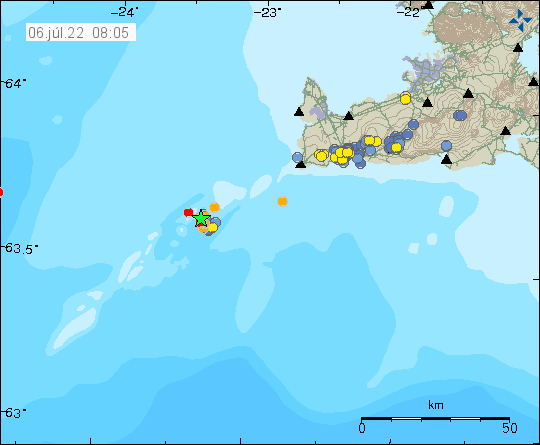
On Monday (4-July-2022) an earthquake swarm started close to Geirfugladrangur on Reykjanes ridge. Largest earthquake on Monday had a magnitude of Mw3,2 and on Tuesday a magnitude Mw3,1 earthquake took place.

Green star on the Reykjanes ridge out in the ocean. Showing the centre of the earthquake activity
Earthquake activity on the Reykjanes ridge. Copyright of this image belongs to Icelandic Met Office.

This earthquake activity is what seems to be increase in earthquake activity overall on Reykjanes peninsula and on the Reykjanes ridge. The ocean is deep at this location and an eruption would have to be a big one to break up to the ocean surface because of depth in the area. I don’t know how many earthquakes have happened in this area, because of more activity on Reykjanes peninsula in last few days.

Earthquake recordings

Because of how old my hardware is and difficulty keeping it running. I have for now stopped recording earthquakes. This is going to be the situation until I can get new hardware. When that happens I don’t know. Raspberry Shake has few stations in Iceland. They can be viewed here. This is the hardware I am going to be using once I can afford to buy it. When that happens I don’t know.

Donations

Please remember to support my work with donations. I am currently really broke, because moving is expensive and I had to pay a lot of bills in July. Thanks for the support. 🙂

On Thursday 26-may-2022 there was a strong earthquake on Reykjanes ridge

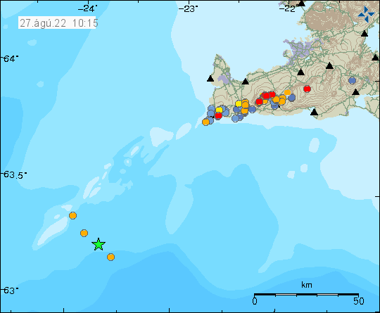
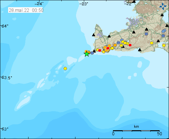
On Thursday 26-May-2022 at 20:11 UTC an earthquake with magnitude of Mw3,5. I think this earthquake was maybe felt in populated areas closest to the earthquake. This earthquake was out in the ocean, a good distance from land.

Green star out in the ocean, a little distance from land. A lot of smaller earthquakes up the Reykjanes ridge and to Reykjanes peninsula, both in red and orange dots
Earthquake activity on Reykjanes ridge and Reykjanes peninsula. Copyright of this image belongs to Icelandic Met Office.

This earthquake possibly is part of the earthquake activity that is happening in Reykjanes peninsula and Reykjanes ridge. It is more difficult to know what is going on in the ocean, than on land.

Posts are going to get delayed for the next few days because I am moving to Denmark.

Strong earthquake this morning north-east of Grindavík town

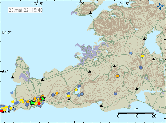
Today (23-May-2022) at 07:14 UTC an earthquake with magnitude of Mw3,5 took place north-east of Grindavík town. This earthquake was felt in Grindavík and in Reykjavík. The earthquake was located in a area that is either inflating or on the edge of area that is inflating.

Green stars both north-east and north-west of Grindavík town along with several orange dots that show smaller earthquakes in the area
Earthquake activity on the Reykjanes peninsula close to Grindavík. Copyright of this image belongs to Icelandic Met Office.

According to Icelandic Met Office news, the inflation around Þorbjörn mountain since the start of this earthquake activity is currently at 45mm. I don’t know how much inflation the crust can take in this area before an eruption starts in this area. Any eruption in this area is probably going to start with few craters that shut down with time and then there is just one crater that erupts until the eruption ends.

Donations

Please remember to support my work with donation. Everything helps me from being broke. Thanks for the support. 🙂

Increased earthquake activity off the coast of Reykjanestá

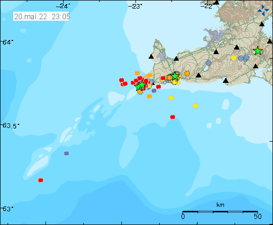
Today (20-May-2022) around 18:00 UTC the earthquake activity off the coast of Reykjanestá, that is part of Reykjanes volcano, increased again after few days of little earthquake activity. The earthquake swarm is ongoing and always changing so this article is going to be short because of that.

Green stars out in the ocean where the main earthquake swarm is taking place just off the coastline of Reykjanestá. This is in south-west direction
Earthquake swarm on the Reykjanes ridge, close to Reykjanestá. Copyright of this image belongs to Icelandic Met Office.

Largest earthquake so far had a magnitude of Mw3,8 and the second largest earthquake had a magnitude of Mw3,5. The Mw3,8 earthquake was felt in Grindavík and on nearby towns on Reykjanes peninsula. A Mw3,0 earthquake took place just north of Grindavík and was felt in the town.

Earthquake swarm north of Grindavík (ongoing activity)

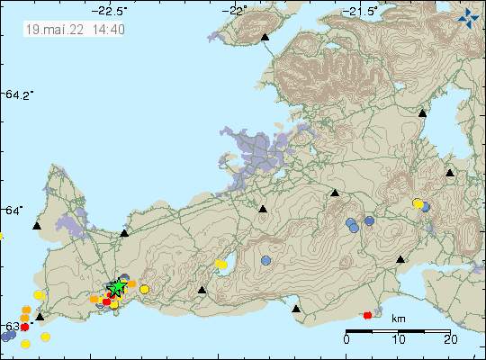
Yesterday (18-May-2022) I forgot to write about the earthquake activity that is ongoing north of Grindavík town. This earthquake activity is either in the new dyke that has formed or ongoing path of the dyke in Svartsengi that has now reached north of Grindavík town. I don’t know what applies here. Skjálftalísa map that Icelandic Met Office has strongly suggests a second dyke, but the results are bit unclear. In the area east of Þorbjörn is a older eruption fissure, I don’t know when it erupted, but it might have been as early as 12th to 13th century.

Six green stars north of Grindavík town, Few red dots show smaller earthquaeks.
Six green stars north of Grindavík town. Copyright of this image belongs to Icelandic Met Office.

Yesterday (18-May-2022) total of five earthquakes happened with magnitude larger than Mw3,0. Largest earthquake had a magnitude of Mw3,5. Today (19-May-2022) at the writing of this article, only one earthquake with magnitude of Mw3,0 has happened. Earthquake activity seems to be slowing down. I am not sure why that is.

Donations

Please remember to support my work with donations. Everything helps me to get trough the month. Thanks for the support. 🙂

Magma dyke has formed between Þorbjörn mountain and Eldvörp on Reykjanes peninsula

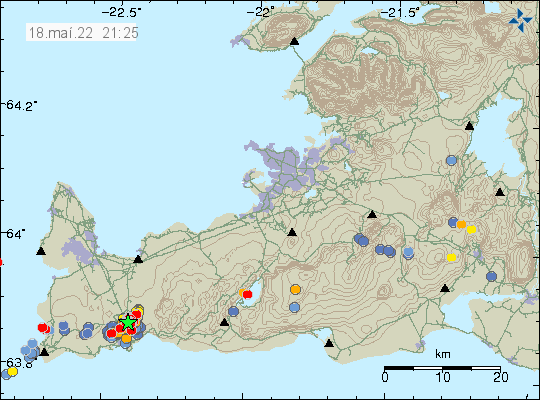
According to news today (18-May-2022) and based on recent measurements, a magma dyke has formed between Þorbjörn mountain and Eldvörp on Reykjanes peninsula. Eldvörp on Reykjanes peninsula where formed during last eruption cycle in the volcano of Reykjanes during 12th and early 13th century, exact times are poorly known. This is in a volcano named Reykjanes and is not connected to Krýsuvík-Trölladyngja volcano that erupted in 2021 (Fagradalsfjall mountain).

The dyke is shallow and narrow according the news that quote scientists from University of Iceland, Earth science department and Icelandic Met Office. The length of dyke is 7 to 9 km and depth is down to 4 to 8 km (?). This also shows up in the GPS data and other data that Icelandic Met Office has access to (I don’t have this level of access).

Red dots north of Grindavík town and a green star showing the main centre of earthquake activity in Reykjanes volcano
Earthquake activity north of Grindavík town. Copyright of this image belongs to Icelandic Met Office.

It is not possible to know when a eruption start or in what area. The main risk areas now are Blue Lagoon, HS hydrothermal energy thermal plant. The town of Grindavík is slightly south of this and is possibly in danger. How this goes depends on where the eruption starts and how large it is going to be. Smaller eruption is less of a problem than a big eruption in this area. All that can be done now is to continue to monitor the situation.

Donation

Please remember to support my work if you can. Thanks for the support. 🙂

Magnitude Mw4,3 earthquake in Eldvörp (Reykjanes volcano)

This is a short article about ongoing activity in Reykjanes volcano.

At 17:38 UTC an magnitude Mw4,3 earthquake took place in Eldvörp crater row. This earthquake was felt over a wide area of south Iceland and on Reykjanes peninsula.

A lot of earthquake activity west of Grindavík town in Eldvörp. A lot of green stars in this area along with new red dots showing smaller earthquakes.
Strong earthquake activity west of Grindavík town. Copyright of this image belongs to Icelandic Met Office.

As it currently is, the earthquake activity in this area is going to continue to increase until an eruption starts. When that might happen is not something I can predict.

Donations

Please remember to support my work with donations if you can. Donations prevent me from being broke. Thanks for the support. 🙂

Updated at 20:52. Icelandic Met Office downgraded this earthquake when it was reviewed again. This article has been updated in accordance with the new information.

Strong earthquake swarm in Eldvörpum (Reykjanes volcano)

Today (15-May-2022) a strong earthquake activity started in Eldvörp crater crow west of Grindavík town. Largest earthquake at the writing of this article had a magnitude of Mw4,1. Stronger earthquakes are a possibility. Total of five earthquakes with magnitude stronger than Mw3,0 have taken place since 11:00 UTC this morning. More than 100 earthquakes that are smaller in magnitude have happened since then.

Five green stars on top of each other west of Grindavík town on Reykjanes peninsula. The area is swarmed with smaller earthquakes and older earthquakes from recent days, few green stars out in the ocean from older earthquake swarm
Earthquakes in Reykjanes volcano in Eldvörp crater row. Copyright of this image belongs to Icelandic Met Office.

I am not seeing any clear signs that this earthquake activity is because of tectonic activity. This earthquake activity is in my personal view because of magma trying to find a path to the surface, something that it seems to struggle with. A process that was also seen just before the eruption in Fagradalsfjall mountain. The difference now is that an eruption in this area might be a magnitude or two larger than an eruption in Fagradalsfjall mountain, until an eruption starts, this is just a speculation. It is impossible to know when an eruption is going to start at this location, or if it is going to start. That is the most likely outcome of all this, but volcanoes remain unpredictable.

Donations

Please remember to support my work with donations if you can. Since donations prevent me from going broke during the month. Thanks for the support. 🙂

Ongoing earthquake swarm in Reykjanes volcano

There is a an ongoing earthquake swarm in Reykjanes volcano and it has been going on for more than a week now. Location of this swarm has moved a little and the main earthquake activity is now at Reykjanestá area out in the ocean. There have been five earthquakes with magnitude above Mw3,0 today (13-May-2022) and the largest so far had a magnitude of Mw3,5.

Five green stars on top of each other out in the ocean at Reykjanestá. A green star north of it from a unverified earthquake. Swarm of small earthquakes close to Grindavík town
Earthquake activity on Reykjanes ridge and on Reykjanes peninsula. Copyright of this image belongs to Icelandic Met Office.

This earthquake activity suggests two things. Either the magma has not been able to find a path to the surface close to Grindavík town. The second option is that there are two dyke intrusions happening in Reykjanes volcano. This earthquake activity slows down but never fully stops it seems. It is unclear why that happens. I am expecting earthquake activity to get stronger until an eruption starts somewhere in Reykjanes volcano.

Donations

Please remember to support my work with donations if you. Thanks for the support. 🙂