Update on the activity between Keilir and Fagradalsfjall mountains

This is a short article written on 17-March-2021 at 17:49 UTC. The situation can change without warning.

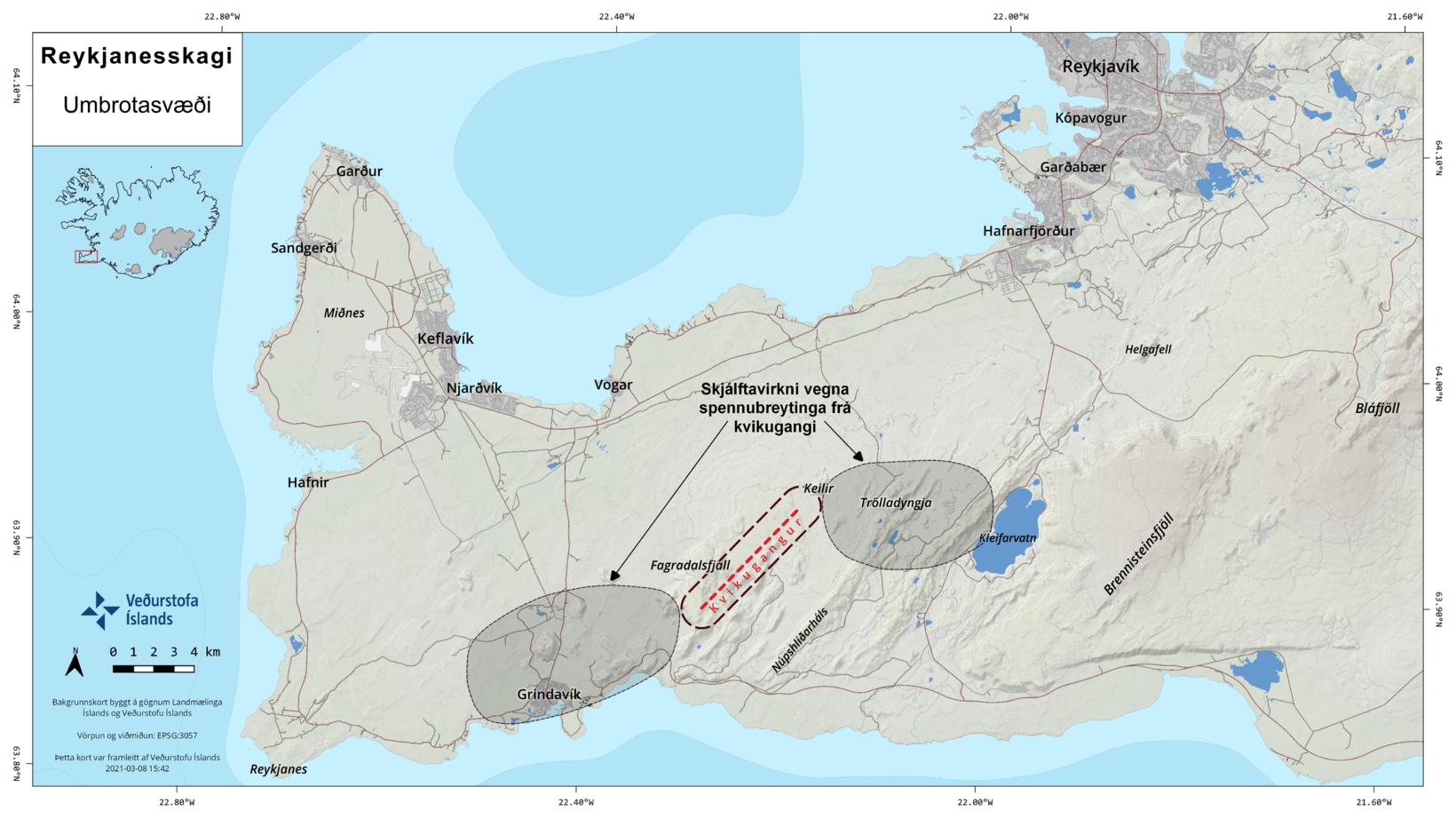
It has been less activity in in Fagradalsfjall volcano (Krýsuvík volcano). Current day to day change is not a lot at the writing of this article but it is also possible that bad weather that is now passing over Iceland is masking some of the smaller earthquakes in the dyke between Keilir mountain and Fagradalsfjall mountain. Inflation continues at what seems to be about the same rate as yesterday (16-March-2021).

Earthquake activity shows but less then in last few days. Most of the red dots are located between mountain Keilir and Fagradalsfjall mountain after change in earthquake after the weekend
Earthquake activity in Fagradalsfjall volcano located between Keilir mountain and Fagradalsfjall mountain. Copyright of this image belongs to Icelandic Met Office.

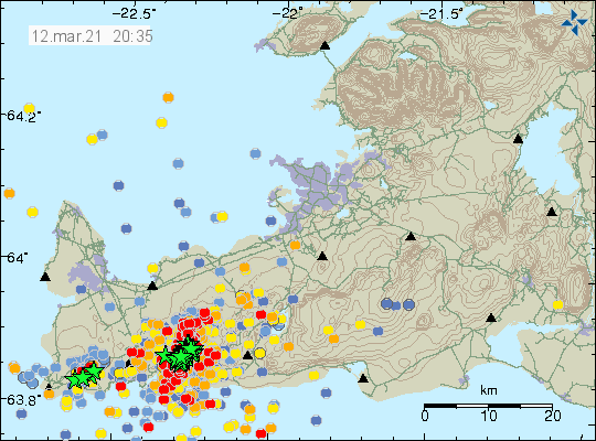
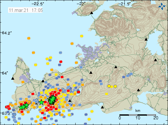
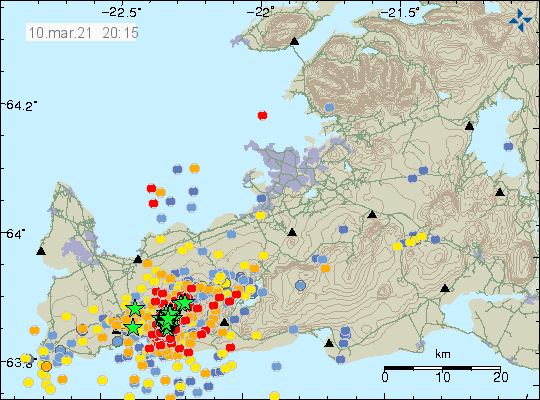
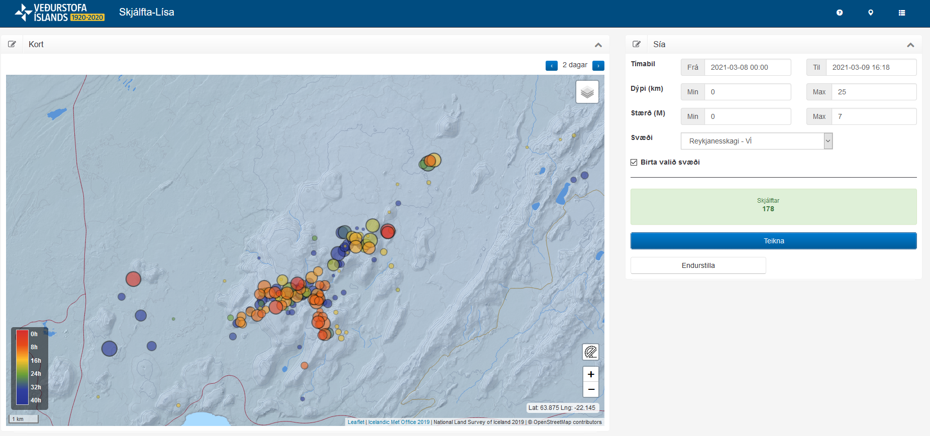
Number of strong earthquakes has dropped after the strong earthquake activity during last weekend (12 to 14 March). What also changed is that the dyke can’t move more south then it already has. It seems that it hit a impasse in the crust that it was unable to break or go around (harder crust is the most common why this happens). The current status is a waiting for the eruption to start and when that happens is impossible to know.

Since there is not a lot of change going on at the writing of this article I am going to slow down the number of updates I am posting. Next update is going to be when something happens or at the latest Monday 22-March 2021.

Web cameras

Beint vefstreymi af skjálftasvæðinu – Borgarfjall (Rúv.is) If an eruption happens it might be visible hereThis web camera no longer works.
Beint vefstreymi af skjálftasvæðinu – EfstaleitiThis web camera no longer works.
Road camera 1
Road camera 2 (night vision/infrared)
Live from Iceland – Keilir – This web camera is working (I think).

Donations

Please remember to support my work if you can. Donations help me staying away from always being broke. Thanks for the support. 🙂

Article updated on 18-March-2021 at 20:07. Web camera updates.

Inflation continues in Fagradalsfjall mountain, eruption expected close to or in Nátthagi valley

This is a short article because the situation is always changing. This article is written on 15-March-2021 at 21:23 UTC. This article is about Fagradalsfjall volcano but Icelandic Met Office updates go to Krýsuvík volcano so I link to that volcano also.

Between Friday and Monday the activity in Fagradalsfjall volcano was really strong. Several earthquakes with magnitude above Mw4,0 took place and the second largest earthquake took place on Sunday 14-March at 14:15 UTC with the magnitude of Mw5,4. Earlier that day at 12:34 UTC an magnitude Mw5,2 earthquake had taken place. According to the news (Icelandic) over 50.000 earthquakes have taken place since 24-February-2021 when this earthquake activity started (20 days ago). Of those six have been larger than magnitude 5, earthquakes with magnitude between 4 to 5 have been 53 and total of 524 earthquakes with magnitude between 3 to 4. Inflation is now reported to be 20 cm or 10 cm on both sides of the dyke. Eruption is expected to happen close to or in Nátthagi valley soon. When that happens is impossible to know but the magma inflow into the dyke doesn’t show any signs of slowing down or stopping.

A lot of red dots on Reykjanes peninsula showing the earthquake activity in Fagradalsfjall mountain area where the eruption is going to happen. Few green stars showing the largest earthquakes on the map.
Earthquake activity in Fagradalsfjall mountain and nearby area. Copyright of this image belongs to Icelandic Met Office.

It has also been reported that the magma dyke managed to push it self a little more south in the line it had been then compared to Friday according to newest data that scientists have access to. Today (15-March-2021) earthquake activity has been small and slow but after 16:30 UTC it started to increase again but at the writing of this article no major earthquake has happened. It has mostly been small earthquakes taking place.

If anything major happens I’ll post update soon as possible.

Web cameras

Beint vefstreymi af skjálftasvæðinu – Borgarfjall (Rúv.is) Nátthagi valley web camera
Beint vefstreymi af skjálftasvæðinu – Efstaleiti
Road camera 1
Road camera 2 (night vision/infrared)

Donations

Please remember to support my work with donations. Everything continues to be locked down with Google Adsense and I don’t know when that is resolved or if that gets resolved at all. Thanks to everyone that has supported me already. Thanks for the support. 🙂

Magma dyke seems to have stopped close to Nátthagi valley south of Fagradalsfjall mountain

This article is short because the situation is always changing. This is about the volcano Fagradalsfjall but I have also added Krýsuvík because that volcano is being updated at Global Volcanism Program website. I am not sure currently what volcano is considered active in this make injection. This article is written at 20:39 UTC.

Today (12-March-2021) at 07:43 UTC an earthquake with magnitude of Mw5,0 at 3,7 km depth took place close to Nátthagi valley just south of Fagradalsfjall mountain. Over the last 48 hours 72 earthquakes with magnitude above Mw3,0 have taken place. This earthquake activity is happening at the south end of the magma dyke that has now stopped moving south but continues to expand based on the earthquake activity that is now happening. This is also the location where an eruption might happen without any warning or strong earthquake activity. Eruption out on the ocean is no longer considered a possibility because the magma dyke stopped moving south.

Dense earthquake activity on Reykjanes peninsula in the Fagradalsfjall or Krýsuvík volcanoes. A lot of green stars on the map
The dense earthquake activity in Fagradalsfjall or Krýsuvík volcano. Copyright of this image belongs to Icelandic Met Office.

GPS data shows that inflation remains heavy and has moved some GPS stations up to 120mm over a time period of two weeks. There are no signs of this inflation stopping or slowing down.

Web cameras

Beint vefstreymi af skjálftasvæðinu – Borgarfjall (Rúv.is) If an eruption happens. This camera maybe has the best view
Beint vefstreymi af skjálftasvæðinu – Efstaleiti
Live from Iceland
Road camera 1
Road camera 2 (night vision/infrared)

Next article is going to be on Monday 15-March-2021 if an eruption doesn’t happen or something else major doesn’t happen. I am hoping to get weekend break this weekend. If that is going to be successful is currently unclear.

Donations

People remember to donate to support my work if you can. Thanks to everyone that have donated already. It helps me a lot. Thanks for the support.

Strong earthquakes west of Grindavík village and update on magma dyke movements

This is a short article about the activity in Fagradalsfjall volcano. This article is written on 11-March-2021 at 17:34 UTC.

This morning at 08:53 UTC an earthquake with magnitude of Mw4,5 took place west of Grindavík town. Second earthquake with magnitude of Mw3,2 took place at 09:03 UTC. This earthquakes are not connected to any magma movement in this location. The reason for this earthquake activity is because of the inflation from the Fagradalsfjall volcano dyke. According to new measurements the dyke in Fagradalsfjall volcano is moving around 500 meters every 24 hours. Currently the dyke has moved more south but it was moving south-west yesterday and the days before that. Today (11-March-2021) the dyke has only 2 to 3 km left until it goes under the ocean and a road called Suðurstrandarvegur (road 427). If the magma reaches the ocean and an eruption starts, it is going to be an explosive eruption while the ocean can access the main craters that are erupting. Depending on locations this can go on for weeks and is going to form new islands that might only exist for short time period until the ocean erodes them away.

Dense earthquake activity on Reykjanes peninsula in the volcano Fagradalsfjall. Three green stars west of Grindavík town and a lot of red dots showing new earthquake activity.
Earthquake activity in Fagradalsfjall volcano. Copyright of this image belongs to Icelandic Met Office.

If an eruption happens before the magma dyke reaches the ocean the magma only has 2 to 3 km left until it reaches the ocean and it is now expected if that happens that the lava is going to reach the ocean in 6 to 10 hours and go over Suðurstandarvegur (road 427). Since 24-February-2021 over 34.000 earthquakes have been recorded by Icelandic Met Office in this volcano activity.

Web cameras

Beint vefstreymi af skjálftasvæðinu – Borgarfjall (Rúv.is) New!
Beint vefstreymi af skjálftasvæðinu – Efstaleiti (Rúv.is)
Road camera 1
Road camera 2 (night vision/infrared)
Live from Iceland

Update on Fagradalsfjall volcano activity on 10-March-2021

This is a short update on the activity in Fagradalsfjall volcano. This article is written at 21:08 UTC.

Since Monday 8-March-2021 there has been a lot going on and there are no signs of this activity slowing down. Currently it seems that the volcano dyke is expanding to the south and that is more into Fagradalsfjall mountain that is a earlier eruption structure from maybe few million years ago. This expansion of the magma dyke is resulting in strong earthquake activity and during the night the strongest earthquake had a magnitude of Mw5,1 at 03:15 UTC. Second largest earthquake had a magnitude of Mw4,6 at 08:50 UTC. Over the last 48 hours 68 earthquakes with magnitude above Mw3,0 have taken place. Smaller earthquakes are happening with the rate of 1 to 5 or more earthquakes at every minute. Since 24-February-2021 over 34.000 earthquakes have been recorded by Icelandic Met Office.

Dense earthquake activity on Reykjanes peninsula. Dense location of green stars that shows the location of the main active area. A lot of red dots showing smaller earthquakes
Earthquake activity on the Reykjanes peninsula. Copyright of this image belongs to Icelandic Met Office.

The chance of an eruption are increasing according to Icelandic Met Office in the news this evening. While the magma dyke has space to expand it is going to do so. The magma in the dyke is now at the shallowest only at 1 km depth or less. Exact depth has been problematic to get information about. Eruption can happen without much earthquake activity because how shallow the magma is to the top of the crust. There remains a high risk of an earthquake with magnitude Mw6,0 to Mw6,5. Both in the fracture areas on both ends of the dyke and in Brenninsteinsfjöll volcano.

Next update is going to be on Friday (12-March-2021) unless something major might happen.

Donations

Please donate if you can. Everything is still locked down with Google Adsense that doesn’t seems to have liked the traffic increase my website got when the Fagradalsfjall volcano started going active on 24-February-2021. There is nothing I can do about it since there are exactly zero person to contact with Google Adsense and I just have to hope this is somehow resolved if that is what happens (it might not because Google placed their eggs in the automation basket and that’s not a good thing). Thanks for the support. 🙂

Harmonic tremor pulse during the night until morning in Fagradalsfjall volcano (9-March-2021)

This is a short article on the activity in Fagradalsfjall volcano. This situation is developing quickly and it is impossible to know what happens next.

During the night of 9-March-2021 from 05:20 UTC until around 07:00 UTC an harmonic tremor pulse was detected by Icelandic Met Office. This shows that the magma is still expanding into the Earth crust below Fagradalsfjall mountain and according to Icelandic Met Office it looks like the dyke is expanding in south direction but it is going to take a day or two to confirm that with GPS data.

Earthquake activity in the volcano Fagradalsfjall. Dots on a generated map my a program called Skjálfta-Lísa shows the most recent earthquake activity from midnight until 16:18
Earthquake activity in Fagradalsfjall volcano. This shows the possible location of the south end of the magma dyke. Copyright of this image belongs to Icelandic Met Office.

There have been fewer stronger earthquakes in last few days. While the there are fewer strong earthquakes the amount of earthquakes has not really dropped in any number, most earthquakes are small in magnitude and only few reach magnitude above Mw3,0. This quiet period is not expected to last for any amount of time while magma continues to be injected into the crust of Fagradalsfjall volcano. There continues to be a high risk for earthquake with magnitude Mw6,0 to Mw6,5 along with risk of Mw6,5 earthquake in Brennisteinsfjöll volcano. Currently no magma movement is being detected in Reykjanes volcano, Krýsuvík volcano or Brennisteinsfjöll volcano.

New information about the situation in Fagradalsfjall volcano

This is a short article about the new information published today (8-March-2021) by Icelandic Met Office and Department of Civil Protection and Emergency Management.

New measurements of the situation in Fagradalsfjall volcano show that the dyke intrusion continues to grow and as at its shallowest point at 1 km depth. Possible eruption is expected at the south end of the dyke intrusion (closest to Fagradalsfjall mountain). Earthquakes are going to happen at the south-west end of the dyke and north-east of the dyke because of the inflation the magma is creating in the area.

The dyke shown with dotted line and circle shows the most effective area. Gray areas at both ends shows earthquake effected area
The earthquake areas at the ends of the dyke intrusion, shown in gray areas on this map. The dyke is shown within the line with dot lines. Copyright of this image belongs to Icelandic Met Office.

There are going to be quiet times between high period of activity according to the news about this activity. There is also ongoing risk of a earthquake with magnitude of Mw6,5 in Brennisteinsfjöll volcano and according to Icelandic Met Office that risk has not been reduced in recent days. Outside of the Fagradalsfjall volcano magma dyke, no magma movement has been detected in Reykjanes (Svartsengi?) volcano and in Krýsuvík volcano.

Sources (Icelandic)

Áfram má búast við að virknin á Reykjanesskaga verði kaflaskipt (Iceland, English, Polish, Almannavarnir.is)
Kvikan er á kílómetra dýpi (Rúv.is, Icelandic)

Update on activity in Fagradalsfjall and Reykjanes volcanoes

This is a short update on what is going on in Reykjanes peninsula. This article is written at 16:29 UTC.

Volcanoes in this article

Fagradalsfjall
Reykjanes
Krýsuvík

  • Fagradalsfjall volcano has not erupted since Pleistocene. When last eruption took place is not listed or not known. This the first magma movement in Fagradalsfjall volcano in 11700 years.
  • Eruption risk is now in Reykjanes volcano*.
  • *This might also be a different volcano known as Svartsengi (no Global Volcanism Profile). There is no agreements between maps on this detail for now. Reykjanes volcano might only extend into Reykjanestá and then is mostly under ocean and might not extend into Reykjanes peninsula as sometimes is shown on maps.
  • Krýsuvík volcano has quieted down a little in the last 24 hours. Eruption risk is lower for now in that volcano.
  • Largest number of earthquakes detected in one day was over 3000 earthquakes.
  • In the last 24 hours 12 earthquakes with magnitude above Mw3,0 have happened. Most of them are felt in nearby populated areas.
  • No harmonic tremor has been detected since it ended during the night on 4-March-2021.
  • During the last 48 hours over 3300 earthquakes have been recorded by Icelandic Met Office.
  • New! Magma is now estimated to be at 5 to 6 km depth but might be as shallow as 2 km depth.


Dense earthquake activity in the volcanoes Reykjanes, Fagradalsfjall and Krýsuvík volcanoes
Heavy earthquake activity on Reykjanes peninsula in three volcanoes. Copyright of this image belongs to Icelandic Met Office.

Maps of possible eruption areas has been made by Earth science department of University of Iceland and can be found here. University of Iceland Earth science department also made a lava flow prediction can that map can be found here. Both maps are updated daily on Facebook.

Web cameras

Beint vefstreymi af skjálftasvæðinu – Vogastapi (Rúv.is)
Keilir í beinni (mbl.is)
Óróasvæðið í beinni útsendingu (Vísir.is)
Live from Iceland
Keilir og skjálftasvæðið (YouTube)

Added at 21:12 UTC

Road camera 1
Road camera 2 (night vision/infrared)

Cameras and links might go offline without warning.

Donations

It is possible to support my work with donations. It helps me in current financial situation that has remained rather bad. You should only donate if you can. Other ways to support my website is to let people know about it if they are interested in earthquakes, volcanoes and geology in Iceland. Thanks for the support. 🙂

Article updated at 16:53 UTC.
Article updated at 21:13 UTC.

Krýsuvík volcano update at 19:56 UTC

This is a short update since this situation is developing quickly.

No eruption has started at the writing of this article. Harmonic tremor is slightly lower compared to when it started at 14:20 UTC in Krýsuvík volcano. This drop in harmonic tremor started around 16:00 UTC. This harmonic tremor is ongoing as for writing of this article. There are no signs of the rift valley formation on the surface yet, but it does show up on measurements, both GPS and satellite measurements. Earthquake activity is high at the writing of this article but most earthquakes are small in magnitude but there are few earthquakes with magnitude of Mw3,0.

Earthquake activity in Krýsuvík volcano. A lot of green stars and red dots showing new earthquakes.
Earthquake activity in Krýsuvík volcano. Copyright of this image belongs to Icelandic Met Office.
The earthquake trace shows a dense dots of blue, yellow, orange and red dots. All are earthquakes of different magnitude
Earthquake activity trace of the earthquake activity on Reykjanes peninsula. Most earthquakes are in Krýsuvík volcano. Copyright of this image belongs to Icelandic Met Office.

Web cameras of the possible eruption area can be found in this locations.

Beint vefstreymi af skjálftasvæðinu (Rúv.is)
YouTube stream.

I am going to add more streams as I find them online.

I’ll update soon as possible if anything happens. This situation is changing quickly.

Earthquake activity and more in Grímsfjall volcano (Grímsvötn)

Yesterday (29-January-2021) at 23:34 UTC an earthquake with magnitude of Mw2,4 took place in Grímsfjall volcano (Grímsvötn). There where few smaller earthquakes before and after this largest earthquake. There where no signs of change in harmonic tremor following this earthquake activity.

In the center of Vatnajökull glacier there is a volcano Grímsfjall. East of that a yellow dot shows the location of an earthquake with magnitude of Mw2,4. Grímsfjall volcano is marked by a triangle that shows the location of a seismic sensor to record earthquakes in this area.
Earthquake activity in Grímsfjall volcano. Copyright of this image belongs to Icelandic Met Office.

It has also been reported in the news that glacier plate that is on top of Grímsfjall volcano is now the highest since 1996. Inflation is now taking place in eastern part of Grímsfjall volcano, in a location called Eystri Svíahnúkur. Magma pressure is today (30-January-2021) equal or higher than when the May 2011 eruption took place in Grímsfjall volcano.

Sources / News in Icelandic

Íshellan í Grímsvötnum ekki mælst hærri í 25 ár (Icelandic, Rúv.is)
Fundur í vísindaráði almannavarna (Icelandic, Almannavarnir.is)