Increased activity in Geysir hot spring area

It was reported yesterday (21-October-2024) and today (22-October-2024) that there is a increase activity in hot springs in Geysir area on Saturday 19-October-2024. Many of the hot springs are now hotter and erupting quicker and are more bubbling. Creating a risk for tourist travelling this area. Why this is happening is not known, since there are no signs of movement in the surface and have not been detected by Icelandic Met Office. Video of this increase in activity can be seen on Icelandic Met Office Facebook page.

Geysir hot spring area is part of a small volcano in this area. It last erupted more than 12.000 years ago. When last eruption took place is not know. This volcano is leaving an active period in next 500.000 years to 1.000.000 years, until it becomes extinct volcano. This happens because of the continental drift in Iceland.

Increased hydrothermal activity between Keilir mountain and Trölladyngja mountain

Rúv News is reporting today (10. September 2023) that there has been noticeable increase in hydrothermal activity east of Keilir mountain since end of least eruption close to Litli-Hrútur mountain. According to the news, this shows that magma is now close to the surface without erupting currently. This area is rather large, it is between Keilir mountain and Trölladyngja mountain (part of Krýsuvík-Trölladyngja volcano). There have been reports of increased SO2 vents that is killing moss in this area, along with new steam vents that have been appearing in the last few weeks.

According to Þorvaldur Þórðarson volcanologist, there is a magma shadow in the area around Trölladyngja and that appeared around the time the eruption close to Litli-Hrútur started. This area was noticed by Thomas Fisher earthquake expert from Czech Republic did notice this area having almost no earthquakes at all. Showing that magma has pushed it self into the crust at this location at shallow depth.

The result of this is that next eruption might have more eruption vents, it might erupt at more than one fissure at the same time in parallel. What happens next is unclear, but this large area has gotten really warm and seems to be continuing to expand.

Rúv news

Fylgjast vel með auknum jarðhita austan við Keili (Rúv.is, has map of the area)

New hot springs detected at Road 1 in Hveradalabrekka in Hengill volcano

The Icelandic Road administration did send out this news report today that new hot springs have been detected at Hveradalabrekka on Road 1 in Hengill volcano. This is an area that sees some heavy traffic. I can’t post pictures here because of copyright, but they can viewed in the news article below.

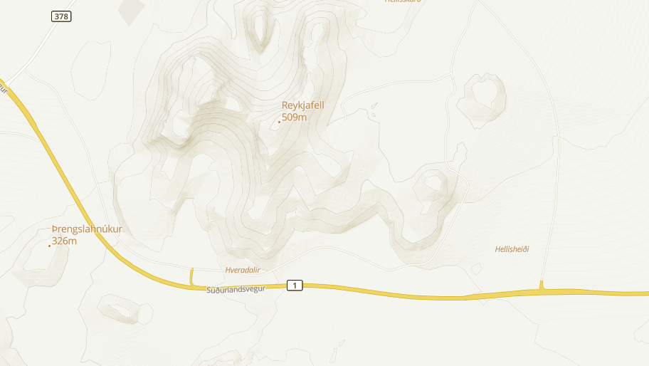
According to the Icelandic Road administration it seems that the area in question has been getting warmer for some time. According to them the current temperature around 86 degrees celsius. This is the area on a map from ja.is website.

The main road one as it is south of Reykjafell mountain in Hengill volcano. Also on this map is Þrenslahnjúkur and Hveradalir are marked in on the map.
The main road 1 on Hengill volcano. Close to the area that is now warming up. Screenshot of map from ja.is.

Next is to check why this is happening and if there is any risk the Road 1 in this area and if anything can be done if that’s the case. I am unclear on what is going on, since this area (I don’t think this one, but nearby) is known for hot spring activity. There has been some earthquake activity at this location in recent months and that is possibly connected to this new hot spring activity. On 9th of May this area had a Mw1,1 earthquake at the depth of 4 km. Over a time period of 130 days, the number of earthquakes in this area is not unusual for Hengill volcano or Reykjanes peninsula in general. This area of Road 1 might continue to get warmer over the next few months.

Vegagerðin news in Icelandic

Jarðhitavirkni undir Hringvegi (vegagerdin.is) – has pictures of the area.

Update

Rúv has published a news about this and has a video of the area where this new hot spring activity is happening. This is new because vegetation is in this area and is now dying off.

Allt að 100 gráðu hiti mælist við veginn (Rúv.is, Icelandic)

Update 2

Icelandic Road Administration web camera shows the new hot spring area. The web camera can be viewed here.

Article updated 12. May 2023 at 20:41 – Reykjavík time (+0 GMT)
Article updated 14. May 2023 at 13:01 – Reykjavík time (+0 GMT)

Glacier flood confirmed from Skaftárkatlar cauldron

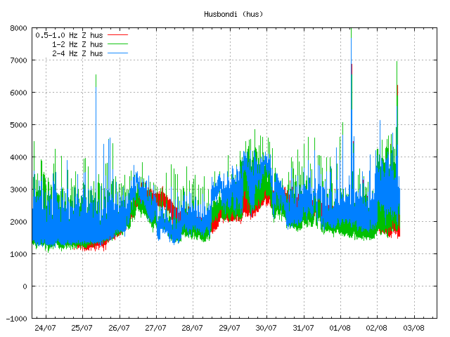
It was confirmed today (02-August-2018) that glacier flood has started from Skaftárkatlar cauldron. According to the news the GPS monitoring station close the cauldrons started to drop around midnight. Around same time harmonic tremor started to change on nearby SIL stations.


Harmonic tremor on nearby SIL station due to glacier flood. Copyright of this image belongs to Icelandic Met Office.

It can take up to a week for the glacier flood to finish, but that depends on the amount of water in the cauldron that is emptying it self. According to the news the eastern Skaftákatlar cauldron is now emptying it self. It last did so three years ago.

Donations

Please remember to support my work with donations. It help me buying food and other stuff I need to write articles here. Thanks for the support. 🙂

Minor earthquake swarm in Torfajökull volcano

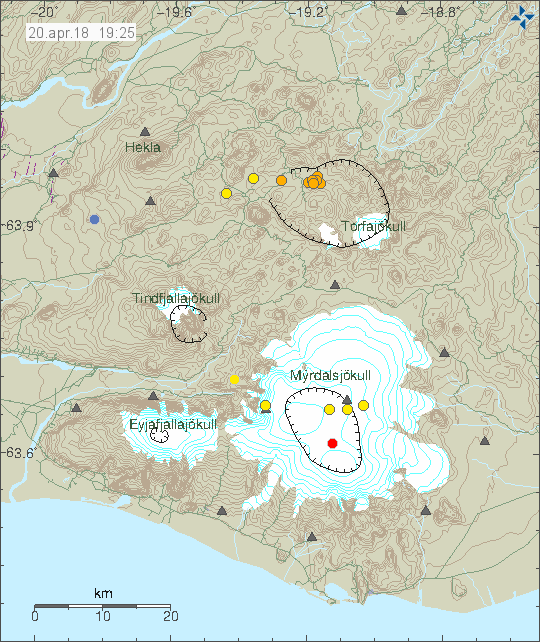
This morning (on 20-April-2018) an earthquake swarm took place in Torfajökull volcano. This was a minor earthquake swarm and largest magnitude was 2,4. All other earthquakes where smaller in magnitude.


The earthquake activity in Torfajökull volcano. Copyright of this image belongs to Icelandic Met Office.

There isn’t a lot happening in Katla volcano on this image. It is all quiet at the moment. In general it is also really quiet in Iceland at this moment.

Donations

Please remember to support my work even if it is quiet at the moment in Iceland. It is impossible to know when that changes. I also have the bill problem for May ongoing and that is explained here. Thanks for the support. 🙂

Minor increase in conductivity in Múlakvísl glacier river from Mýrdalsjökull glacier (Katla volcano)

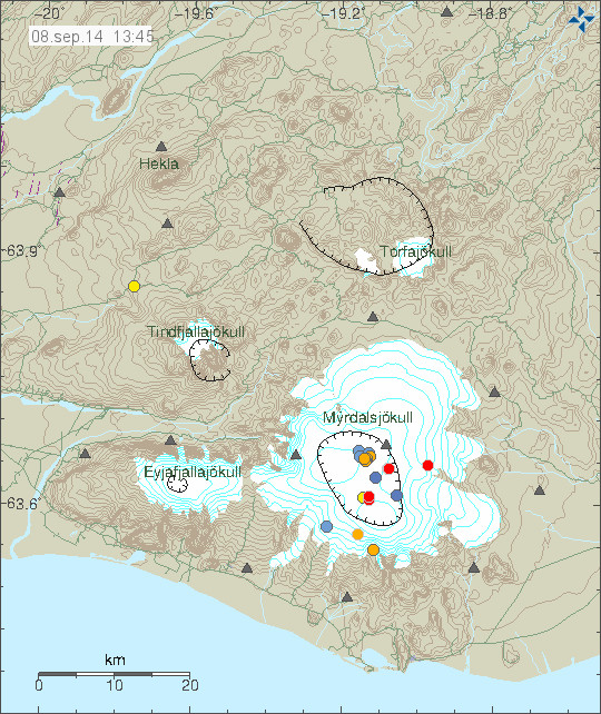
Over the past few days there has been a minor increase in conductivity in Múlakvísl glacier river that comes from Mýrdalsjökull glacier. This is the glacier that is on top of Katla volcano. There is no unusual earthquake activity taking place in Katla volcano at the moment.

140908_1345
There is little activity in Katla volcano today. Copyright of this image belongs to Icelandic Met Office.

The reason why conductivity is higher in Múlakvíl glacier river over the past few days is that there are cauldrons in the glacier. Those cauldrons are created by hydrothermal areas in Katla volcano caldera. They empty them self on regularly during the year. There is no risk of eruption in Katla volcano at the moment. Activity is well below normal background activity fro Katla volcano.

Minor earthquake swarm in Kverkfjöll volcano

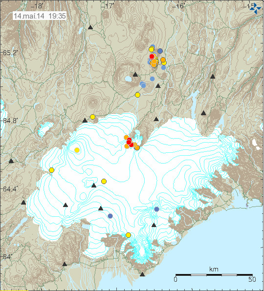
Today (14-May-2014) a minor earthquake swarm took place in Kverkfjöll volcano. Earthquake activity is not common in Kverkfjöll volcano, but it does happen once in a while. This does not mean the volcano is about to erupt, this was just an earthquake swarm taking place. No earthquake reached the magnitude 2,0 in this earthquake swarm.

140514_1935
The earthquake swarm in Kverkfjöll volcano (red dots at north-east part of Vatnajökull glacier). Copyright of this image belongs to Icelandic Meteorological Office.

There are no clues to why this earthquake swarm took place. This might have been a magma injection in the volcano, or this might just have been a change in the highly active hydrothermal areas in the volcano. There was no change at all in harmonic tremors in the volcano during this earthquake swarm. Kverkfjöll web-camera can be found here, it has however not updated since 1-May-2014. I am not sure if this means anything for Kverkfjöll volcano, as such I am just waiting too see what happens next in Kverkfjöll volcano.

Donations: Please remember to donate to support my work. I have less then 3,30€ (25 DKK) to of survive the remaining of this month. Thanks for the support.

Waiting for the eastern Skaftá glacier cauldron

The glacier flood in Skaftá glacier river is almost over or is over at present time (21-January-2014). This however does not mean that everything is over. Since there are two cauldrons in the Vatnajökull glacier in the Hamarinn volcano it means there is more water stored there now then has now flooded from the glacier. It is now clear that the eastern Skaftá glacier cauldron in Vatnajökull glacier has not emptied it self in this flood from the western Skaftá glacier cauldron.

skaftarkatlar.svd.19-Januar-2014
The eastern (Eystri) and western (Vestari) cauldrons in Vatnajökull glacier. Copyright of this image belongs to Icelandic Meteorological Office.

When the eastern glacier cauldron empties it self they are expecting a lot larger glacier flood to take place. Since there is a lot more water holding up in the eastern Skaftá glacier cauldron. It is also longer since it flooded and emptied it self. Last glacier flood from the eastern Skaftá glacier cauldron was in the year 2010. More information on how this flood system works can be found here (in Icelandic) on Icelandic university website geology department.

Glacier flood started in Skaftár glacier river

It was announced today (19-January-2014) that glacier flood has started in Skaftá glacier river (or connected rivers) from Skjaftár cauldrons in Vatnajökull glacier. Currently the water is discharging from Skaftár cauldrons at the rate of 370 m3/s according to Icelandic Meteorological Office. So far no changes have taken place in harmonic tremors close to Hamarinn volcano where the Skaftár cauldrons lie within Vatnajökull glacier.

Smell of hydrogen sulphide has been detected by people living close the rivers that the glacier flood is discharging into. There is a considerable risk of poisoning if people get to close the rivers that hold the flood water. It is currently believed that it is the western Skaftár cauldron that is now emptying, that one did empty it self back the in the year 2012. That is however not going to be confirmed until the area can be checked by flying over it and see what is taking place at this location. That might take few days since it is dependent on weather when it is possible to do such flight.
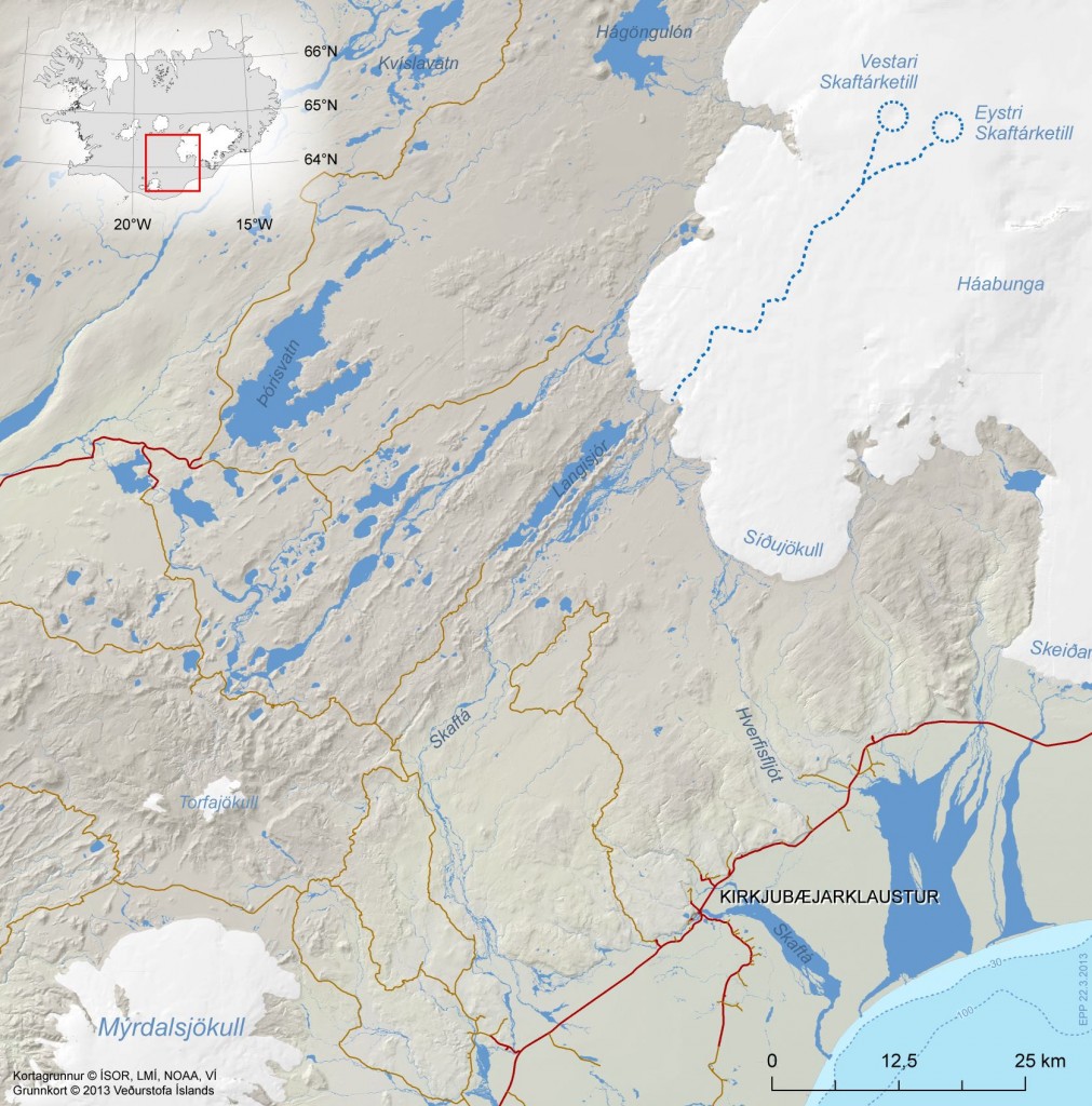
skaftarkatlar.svd.19-Januar-2014
Location of Skaftár cauldrons in Vatnajökull glacier. Copyright of this image belongs to Icelandic Meteorological Office. Picture is taken from Icelandic Meteorological Office Facebook page.
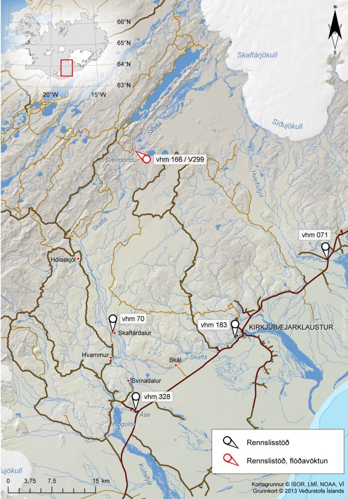
skaftarkaltar.rennsli.svd.19-Januar-2014
The current flood in Skaftár glacier river. The water monitoring stations around Vatnajökull glacier. Red stations are monitored for floods, black ones are normal flow stations. Copyright of this image belongs to Icelandic Meteorological Office. Picture is taken from Icelandic Meteorological Office Facebook page.

Uncertainty level has been declared in the area do to this glacier flood by the Civil Protection and Emergency Management in Iceland. It is advised against people travelling in the area while this glacier flood takes place. On Vatnajökull glacier there is also a risk of new cracks forming in the glacier was the cauldron is emptied of water in the next few days. This cracks are dangerous and really deep and wide on the top, but get narrower closer to the end of them. It is possible to monitor the glacier flood here on Icelandic Meteorological Office website.

Icelandic news about this. Some English text is in some of the news. It is possible to use Google Translate on this, but result can be unreliable.

Skaftárhlaup er mjög líklega hafið (Rúv.is, maps, English text)
Skaftárhlaup hafið en það vex óvenju hægt (Rúv.is, Icelandic, maps)
Óvissustig vegna Skaftárhlaups (Rúv.is, Icelandic, maps)

Skaftárhlaup er hafið (mbl.is, English text)
Óvissustig vegna Skaftárhlaups (mbl.is, Icelandic)
Fundað um næstu skref (mbl.is, Icelandic)

Post updated at 20:34 UTC on 19-January-2014.

Increased conductivity continues in Múlakvísl glacier river (Katla volcano)

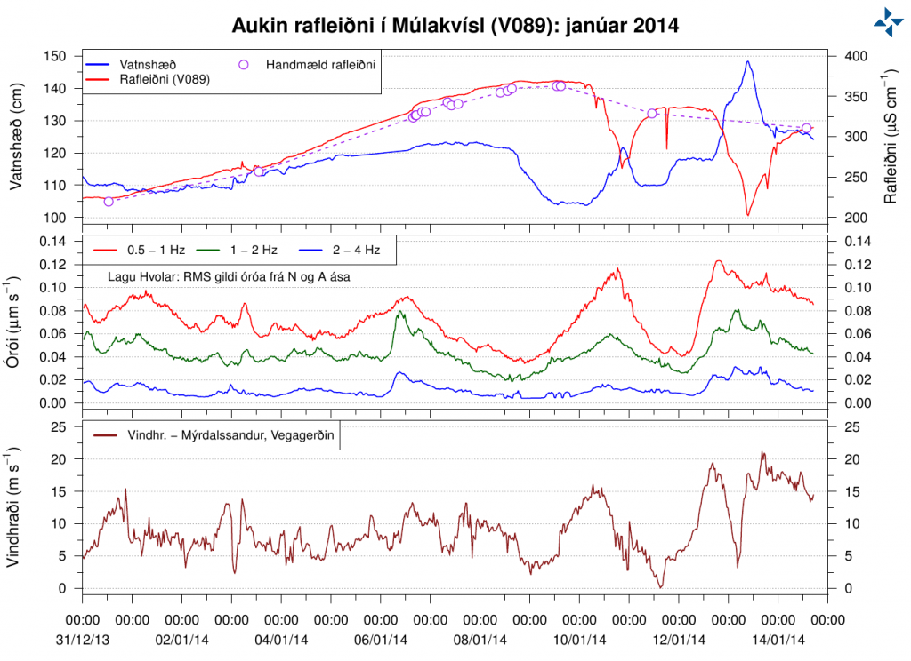
Last week I wrote about increased conductivity in Múlakvísl glacier river that comes from Mýrdalsjökull glacier (Katla volcano). This trend has continued into second week with the conductivity. The conductivity in Múlakvísl is now on the range of ~327 to ~360 µS/cm. There has also been a slight increase in water levels following this change in Múlakvísl glacier river. Normal value for this time of year according to Icelandic Meteorological Office is ~180 µS/cm in Múlakvísl glacier river. Since 31-December-2013 the conductivity in Múlakvísl glacier river has always been over 220 µS/cm.

rafleidni.mulakvisl.januar.1-15.2014
Conductivity in Múlakvísl glacier river. Top: conductivity. Middle: Harmonic tremor. Bottom: Windspeed. Copyright of this image belongs to Icelandic Meteorological Office.

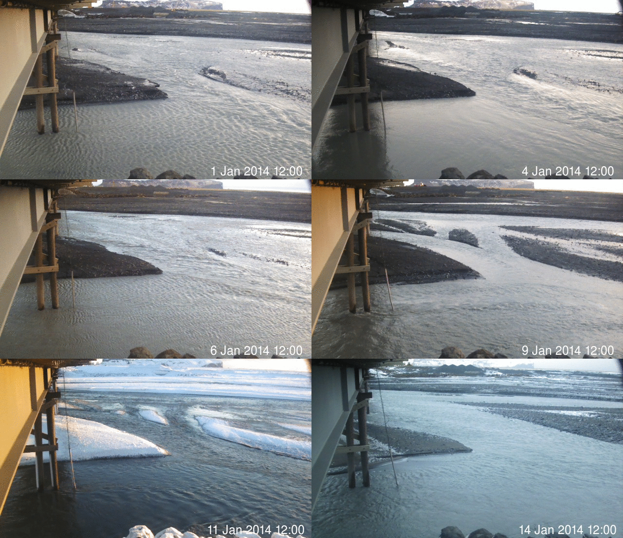
mulakvisl_animated
Animated image from Icelandic Meteorological Office showing changes in Múlakvísl glacier river during this time period. Original image can be found here. Copyright of this image belongs to Icelandic Meteorological Office.

No harmonic tremors or earthquakes have been detected (besides normal activity) following this changes. What is taking place is that a cauldron in Mýrdalsjökull glacier is now leaking melt water that has been built up due to hydrothermal (hot springs) activity under the glacier. So far it does not appear that current changes in Múlakvísl glacier river mean anything at all. If that is going to change is impossible to know at this point.

Icelandic News about this

Rafleiðni há en enginn órói mælist (mbl.is)

Donation notice: Please remember to support me so that I can continue to report on volcano and earthquake activity in Iceland.

Post updated at 19:09 UTC on 15-January-2014.
Post updated at 20:49 UTC on 15-January-2014.