
Today (27. December 2022) an earthquake swarm took place in Fagradalsfjall volcano. This earthquake swarm was small in magnitude, as most earthquake swarms are in Fagardalsfjall volcano.
Continue reading “Earthquake swarm in Fagradalsfjall volcano”
Earthquake swarm in Krýsuvík-Trölladyngja volcano
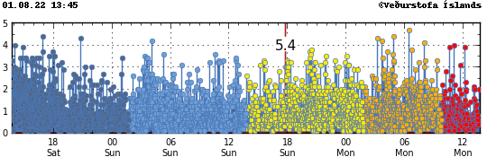
Today (21. December 2022) an earthquake with magnitude of Mw3,4 took place in Krýsuvík-Trölladyngja volcano. This earthquake is because of inflation in Fagradalsfjall volcano. This possibly means that the inflation in Fagradalsfjall volcano is reaching critical point and might result in a eruption soon, when that point is reached is difficult to know.
Continue reading “Earthquake swarm in Krýsuvík-Trölladyngja volcano”
Possible dyke intrusion in Fagradalsfjall volcano
Early morning today (10-November-2022) an swarm of earthquakes took place slightly north of the place where the eruption in August 2022 took place in Fagradalsfjall volcano. This possible dyke intrusion was small and only lasted for about 1 hour before it stopped. Depth of the earthquakes was from 5 km to 7 km.
This activity might give a clue on in what area next eruption is going to take place in Fagradalsfjall mountain. Based on earlier eruption there won’t be any warning before an eruption earthquake swarm starts. In August that eruption started with a minor earthquake swarm, created from a dyke intrusion that was happening. In the hours before an eruption starts there’s going to be a strong earthquake swarm, based on what happened just before the eruption in August. It is interesting if the eruption activity moves north-east, rather than south-west. Why that happens, if it does so, is not something I am clear on why happens.
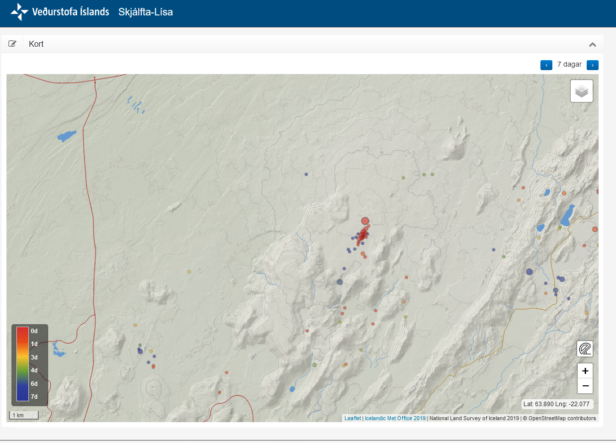
Earthquake swarm in west part of Fagradalsfjall volcano
This morning on 23-October-2022 an earthquake swarm took place in west part of Fagradalsfjall volcano. Largest earthquake in this swarm so far had a magnitude of Mw3,0.
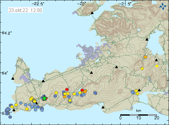
This earthquake activity is the result of magma pushing up into the crust at around 5 km depth. This is not a large dyke intrusion and possibly won’t result in a eruption, unless there’s a sharp increase in earthquake activity and that has happened (the August 2022 eruption started this way). This is currently a situation that requires monitoring for changes. If anything is going to happen is impossible to know.
Earthquake activity has started to increase in Fagradalsfjall and Reykjanes volcanoes
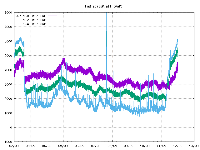
Since yesterday (06-October-2022) the earthquake activity has been increasing in the volcanoes Fagradalsfjall and Reykjanes volcanoes. Please note that Global Volcanism Program has updated the informations regarding Fagradalsfjall mountain and now classifies it as its own volcano, this is after a new report and information from Icelandic Met Office. From now on I am going to use that classification when updating on activity in Fagradalsfjall volcano. I’ll not update older articles (too much work), but this also applies to them as such.
This also means that Fagradalsfjall is a new volcano in Iceland.
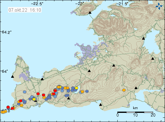
Earthquake activity at start of an eruption cycle in Fagraldsfjall volcano are not large. They grow larger once magma has started to push into the crust, until then the earthquake activity only seems to happens with minor earthquake swarms.
Article updated with new information.
Donations
Please remember to support my work with donations. This month I am really broke. Thanks for the support. 🙂
Update on 5-August-2022 on the eruption in Meradalir valley
This is a short update because not much has changed in the last 24 hours in the eruption in Meradalir valley in Fagradalsfjall mountain.
- The eruption is now in 120 meter long eruption fissure. Currently the output of the eruption is around 18 m3/sec according to yesterday’s measurements.
- The new lava has now flowed over the lava from last year (2021) and into eastern Meradalir. This is about 1 km distance that river of lava has flowed. Image of that can be found here on Facebook.
- According to chemical analyse of the magma. This is the same magma that was erupting when the eruption in the older crater stopped erupting in September. This shows that this magma is older and the new magma has not yet reached the surface.
- Fissures on the ground north-east of the eruption site have started to move and getting wider according to experts that are in the area. This strongly suggests that an eruption is about to happen soon in that location. When it starts is impossible to know. But this is going to close one way to the eruption and if eruption starts in new location south of the crater, seeing and viewing this eruption might start to get difficult or impossible, at least the part in Meradalir were the current eruption is happening now.
I think that is all for this Friday. Next update is going to be on Friday 12-August unless something major happens in this eruption and that might just happen.
Donations
Please remember to support my work with donations. Thanks for the support. 🙂
Update on 1-August-2022 on the earthquake swarm in Fagradalsfjall mountain
This is a short update on the earthquake swarm in Fagradalsfjall mountain and nearby area. This is written on 1-August-2022 at 13:47 UTC.
The situation on Reykjanes peninsula is always updating so information in this article can be in part or in whole get obsolete quickly. Largest earthquake during the night had a magnitude of Mw4,7. This might not be the largest earthquake today, since larger earthquakes are always a possibility.
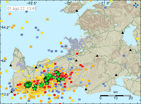
GPS data have started to show a large displacement over the last 48 hours. The 24 hour GPS displacement can be found here and 8 hour GPS displacement data can be found here (find Reykjanes peninsula). This shows that magma is pushing its way though the crust at fast speed, but has not yet broken up trough the crust. When that happens is impossible to know, but this might not be a long wait based on the speed the magma is going. Current depth of the magma is around 2 to 4 km.
Deep inflation detected in Fagradalsfjall mountain
According to a news report today (16-November-2021) inflation has been detected deep under Fagradalsfjall mountain, that is part of Krýsuvík-Trölladyngja volcano system. This inflation suggests that an eruption might start again in Fagradalsfjall mountain, it remains impossible to know when such an eruption might start. Since there is a lot that suggest this inflation is because of magma collecting at depth under Fagradalsfjall mountain. When or if that results in a eruption in the future is impossible to know.
This inflation is now large enough to be seen on satellite images that monitors deformation in the upper crust. In the upper crust this deformation appears small, but that is not all the story in this.
Icelandic News (in Icelandic)
Gosið enn í dvala – Mæla litlar hreyfingar á miklu dýpi (Rúv.is)
Donations
Please remember to support me. In November I am really broke in November because of computer repairs. Thanks for the support. 🙂
Massive lava cave opens up, results in lava flood down to Nátthagi
Yesterday (15-September-2021) around 11:10 UTC a large lava cave just south of the crater in Geldingadalir had a roof collapse in a small area or a lava breakup in the surface. This resulted in the lava flow down Geldingadalir into Nátthagi. The flow covered Geldingadalir in less than 20 minutes. After that it did reach the barrier that stops it from going into Nátthagakriki, if that happens both walking path A and B are going to get closed forever or having to be redrawn from their current locations. Lava down that path also allows the lava flow to go in the direction of Grindavík town and nearby roads.
The lava flow yesterday did go down into Nátthagi but didn’t get far into there compared with the older lava it was flowing on top of. This sudden lava flow did put people in danger and shows that the lava field is full of dangerous caves that can collapse or burst open at any time without any warning. The lava flow that started yesterday is ongoing best to my knowledge. But the view has been limited due to fog and bad weather in Fagradalsfjall mountain this evening.
One or two idiots where seen walking on the crater rim yesterday and I think this are the same people that Icelandic coast guard had to transport from Gónhóll since they where unable to get back because of the new lava flow that had happened when they where there.
The crater is now ~334 meters above sea level high. Currently the crater is now growing in height but that can change without warning.
Pictures of this new lava flow are on social media. I can’t use them because of copyright but if searched they can be found and viewed. There are also some amount of videos of this lava flow on YouTube.
Fagradalsfjall mountain is part of Krýsuvík-Trölladyngja volcano system.
Added 10-January-2022
This article can be found in Spanish here.
Update on the Fagradalsfjall mountain eruption on 12-September-2021
This is a late and short update on the eruption in Fagradalsfjall mountain on 12-September-2021. Fagradalsfjall mountain is part of Krýsuvík-Trölladyngja volcano system.
Yesterday (11-September-2021) at around 05:00 the harmonic tremor on SIL stations around Fagradalsfjall mountain started to show an increase in harmonic tremor after a break of 8 days. It took few hours for the magma to reach the crater and lava was visible in the crater around 12:00 UTC.
There have been possible new vents been opening up yesterday and today in the lava field. Icelandic Met Office says that this is a lava flow under the old colder lava and is now breaking up and looking like new vents. I don’t know yet if this is accurate, but it is my early assessment that this are new vents and are going to build new crater, at least there is a possibly of crater building if the new vents stay active long enough.
If this are new craters as I suspect, then they are going to change the lava flow quickly and increase the output of the lava flow from what it was. It might soon start to flow down into Nátthagi and other locations that are nearby.
It is a big question if the cycle eruption with no activity for hours has stopped for now. If this has turned back into an eruption that goes in 24 hours a day, that is going to allow the lava field to reach a lot more distance then before.