Status update on Bárðarbunga volcano at 22:11 UTC

This information is going to get outdated quickly.

  • Eruption in Holuhraun continues and there are no signs about it ending any time soon.
  • Lava lake has formed in one of the south crater according to the news today. The crater is not erupting at the moment.
  • Earthquake activity continues along the dyke south of the Holuhraun eruption.
  • Bárðarbunga continues to drop and I am estimating that the drop today is around 1 meter a day. This number has not been confirmed. Last confirmed number on the drop was that the Bárðarbunga volcano was dropping 90cm/day.
  • The area around the eruption site is toxic. Due to ever changing wind in the area the risk of getting SO2, CO, CO2 and other toxic gases over one self is always present.
  • There are warning in place for the SO2 pollution in Iceland at the moment. The warnings are issued based on wind direction at any given time.
  • The lava continues to flow into Jökulsá á Fjöllum glacier river. This lava is going to create a dam in next few days. The lava is flowing into the river at such force it doesn’t stop and doesn’t cool down properly to stop the flow of new lava into the glacier river.
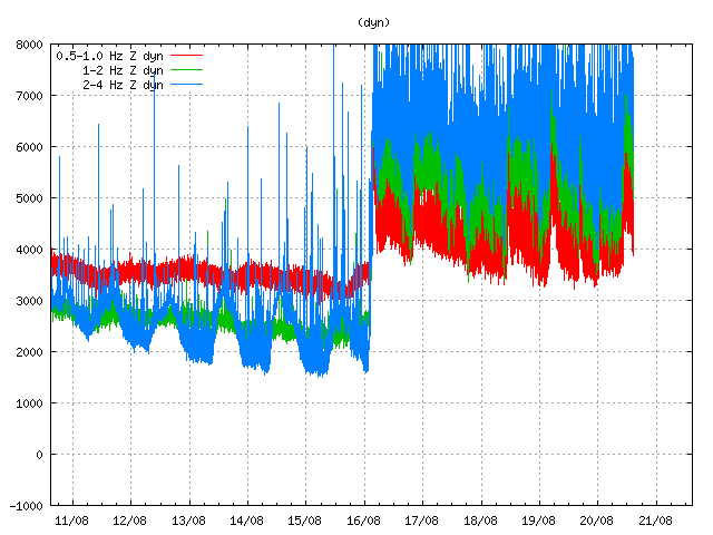
  • I have been seeing harmonic tremor spikes all day today. I have traced them to Bárðarbunga volcano. I am not sure on location. It is difficult to know for sure what this means at the moment.
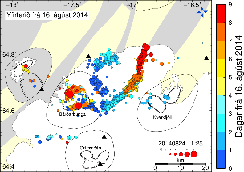
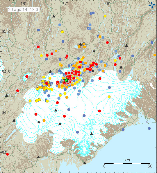
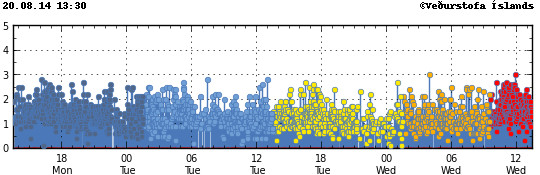
Earthquake activity

140911_2055
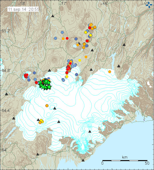
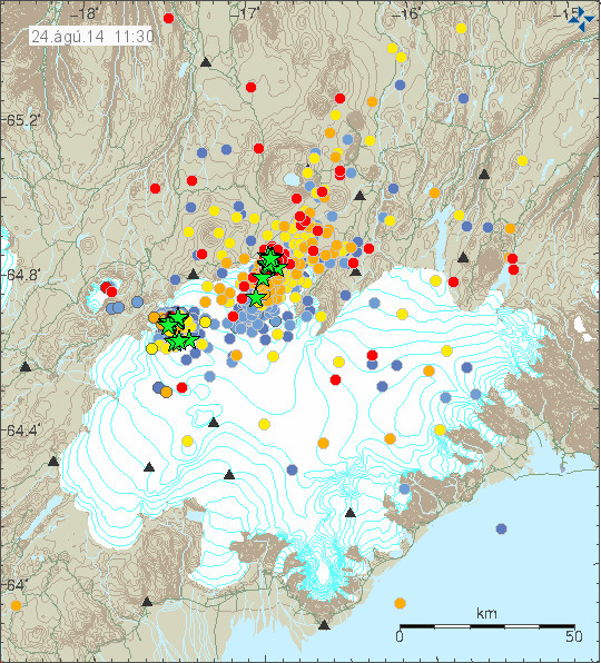
Earthquake activity today. Notice how the green stars (earthquake above magnitude 3,0) form a circle around the caldera that is about to collapse into it self. Copyright of this image belongs to Icelandic Met Office.

140911_2055_trace
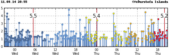
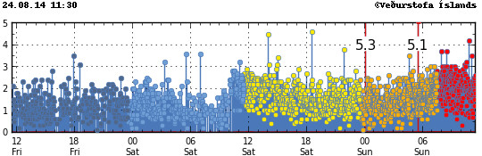
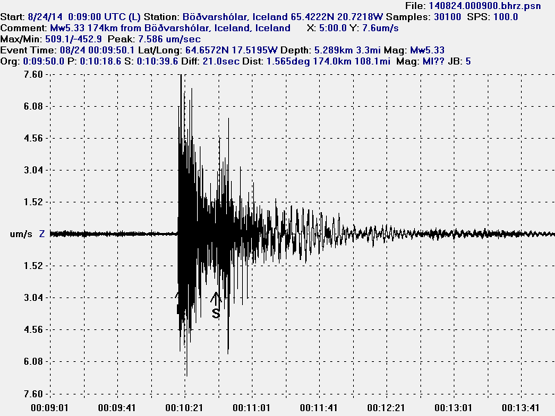
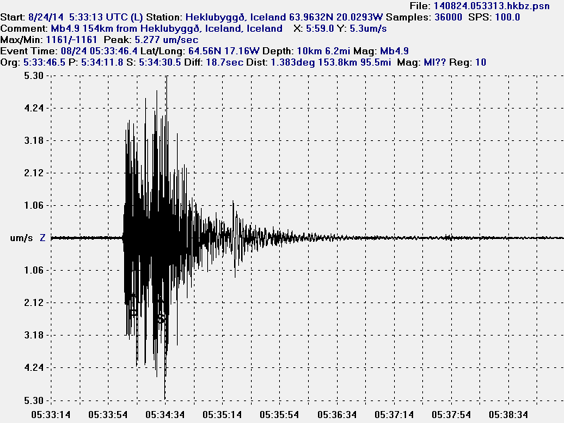
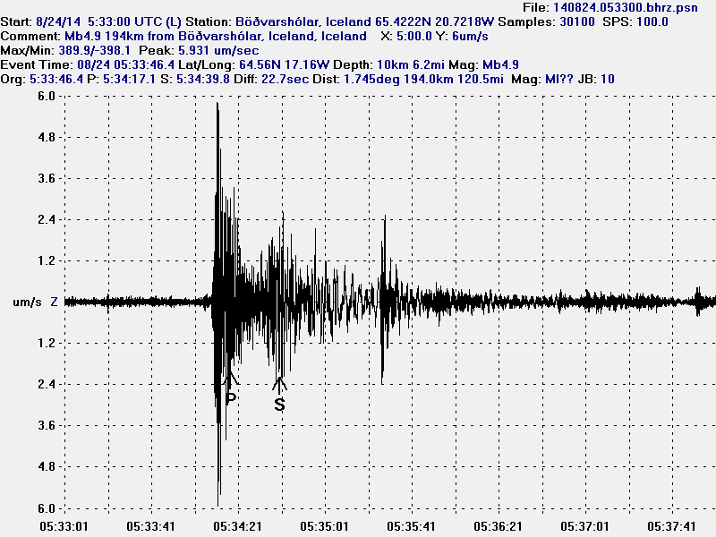
The earthquake trace of the earthquakes today. The larger earthquakes are spaced around 12 hours apart. I don’t know why that is. Copyright of this image belongs to Icelandic Met Office.

Tungnafellsjökull volcano

There has been earthquake activity today in Tungafellsjökull volcano. I don’t know what this means since I don’t have any history about eruptions in that volcano. None have been document in the past 1000 years, and none have shown up in the data for the past 8000 years at least. What I do know is that I suspect the volcano might have started to prepare for an volcano eruption in the future. At least Tungafellsjökull volcano was showing slightly higher activity in past few months than normal, but that earthquake activity did stop and everything did go back to normal until now. This might be as simple as just stress adjustment in the crust in the area. At current time I don’t think an eruption is imminent in Tungafellsjökull, but with no history to work with this volcano might surprise me and everyone else. For the moment I think it is just earthquake activity until I am disproved by the volcano or this earthquake activity just stops.

The caldera formation in Bárðarbunga volcano

The new caldera that is now forming in Bárðarbunga volcano is a large event, since Bárðarbunga volcano is a large volcano. GPS data (website here) says that here is still inflation ongoing in Bárðarbunga volcano and at the moment mostly in the dyke. What is so dangerous with this are many factors. Here is the top list of them.

  • The drop in certain parts of Bárðarbunga volcano down its slopes is up to 1800 meters.
  • The glacier over parts of Bárðarbunga volcano are up to 850 meters thick in the caldera. Outside the caldera the glacier is up to 600 meters thick.
  • There are hydro-power dams south-west of the Bárðarbunga volcano. Glacier flood might go that way. There are also some populated areas that might be at risk depending what way the glacier flood would go.
  • Populations at north of Jökulsá á Fjöllum glacier river (downstream) are at risk from large glacier flood. So are two bridges, the third one that is up on the high lands is not going to be saved.
  • There is going to be a huge ash cloud once Bárðarbunga volcano collapses into a new caldera. What damage that ash cloud is going to do depends on wind direction. If we have really bad luck we might be looking at air space closure for week or two in Europe depending on wind and weather systems.
  • There are other risks that I don’t about yet.

Bárðarbunga volcano caldera (the current one) is around 70 square km in size, around 10 km wide. With the depth of 850 meters and it is full of glacier as I have mentioned many times before. When this is going to hit disaster mode part of that glacier is going to melt and create massive floods. Even if the caldera collapse might happen there is still a high risk of continued eruption activity after that event. Since this might just be a start of long eruption cycle in Bárðarbunga volcano. Since it had been quiet for a long time until 16-August-2014 when this eruption cycle started in Bárðarbunga volcano. What is happening in Bárðarbunga volcano and is creating of a new caldera. The caldera is just now in its early formation stage, when the later stages start to happen I do not know since I don’t have any past data to work with. This does not happen often in Iceland I think and has never happened before since recording of earthquakes started in Iceland.

Updates

If anything major happens I am going to post updates here.

News bits

Subsidence by hundred of meters possible (Rúv.is)

The media in Iceland is now less occupied with this eruption than before. So it is harder for me to get information that way at current time.

Status update on Bárðarbunga volcano at 21:21 UTC

This information is going to get outdated quickly.

About how I work my data

I do all my data work in my head. Since I don’t have the computer power or the programming skills do so in normal computer. This is generally refereed as “thought experiments” I think. The data set for Bárðarbunga volcano are now huge and it takes me a while to update them and work out what I am seeing.

Caldera collapse is in progress in Bárðarbunga volcano

I know that scientists in Iceland don’t want to mention this in the news and are still hoping for current sequence of events to stop. That is not going to happen, it was already to late when the magma found a way out of the magma chamber on 16-August-2014, all that can be done now is to plan for the eventual collapse of Bárðarbunga volcano into a new caldera. I don’t expect the mountain to make it based on current earthquake activity. Eruptions should also be expected without warning around the circle that the earthquakes have now formed around the magma chamber that is collapsing in Bárðarbunga volcano.

Bárðarbunga volcano is however not going to collapse quickly, while the eruption once it starts in Bárðarbunga volcano is only going to last 1 week at the longest. This type of events takes several weeks to months from start to end. When Askja volcano collapsed in 1875 it started sometimes in the year 1874 and did not end until October 1875 (Global Volcanism Program says 1. Jan, 1875 to 1875, 17 Oct.). So this might take more than six months from start to end and might not end until sometimes next year (2015). There is also a chance this collapse is going to take just several weeks. There is no way to know for sure how long this is going to take, since it depends on many unknown factors. There is also a factor that no caldera collapse has taken place in Iceland since modern recording and monitoring of volcanoes started in Iceland (around 1970).

Current status of the Bárðarbunga volcano

  • Eruption continues in Holuhraun lava field. Most of the craters have now stopped erupting and one is now just emitting gas according to latest reports today.
  • Power of the eruption in Holuhraun is about the same since it started, even if there are fewer vents erupting lava at the moment.
  • Visibility has been limited today due to bad weather in the highland of Iceland.
  • SO2 levels in populated areas in east Iceland did go up to 2550µg/m³ around 15:00 UTC in Reyðjarfjöður village. Health warning was issued for the area during the peak of the SO2 pollution.
  • Largest earthquakes today had the magnitude of 5,5 at 05:25 UTC, second largest earthquake today had the magnitude of 4,8 at 15:51 UTC. Other earthquakes have been smaller. There is now less earthquake activity taking place since magma is not breaking as much crust as before.
  • The caldera has now dropped some 20 meters according to last measurements taken when there was a flight over Bárðarbunga volcano.
  • There continues to be earthquake in the dyke, most of it is in area that is covered with glacier.
  • Eruption in Hamarinn (Loki-Fögrufjöll) volcano is now a possibility. It might start without warning and without any earthquake activity, or just little earthquake activity.
  • Dyke activity might start to go south of Bárðarbunga volcano. It has not happened yet, but there is a high risk of it in my personal view.
  • This is creating stress changes around Bárðarbunga volcano. There is a minimal risk of that starting an eruption in other volcano systems that are nearby. It is not likely to happen, but the possibility is there. The reason is that Bárðarbunga volcano is a large volcano, the second biggest in Iceland in my view. With Hofsjökull volcano being the largest in Iceland in my view.
  • The lava field continues to block the glacier river Jökulsá á Fjöllum. As this progresses there is going to be a natural dam in this area after few days.
  • Seven minor eruptions have been confirmed according to the news today (on Rúv). This is besides the eruptions that where in the glacier free area (and are still ongoing). None of those eruptions seems to have lasted for long.
  • Based on harmonic tremor I think pressure is again increasing in Bárðarbunga volcano magma chamber system. This does not appear to be resulting in more powerful eruption in Holuhraun. That is why I think there is increased risk of new dyke to start forming.
  • Gas output from the eruption in Holuhraun remains high and it is extremely dangerous to go there. The lava field is also creating a lot of local weather in good weather. That also makes this dangerous. This eruption is no place for tourist.

Updates

Updates go here when they happen.

News bits

I am going to add news here in case anything happens.

References list

Caldera (Wikipedia)
Modelling Caldera Collapse (OSU)
Caldera (Science Daily)

Short update on Bárðarbunga volcano at 12:07 UTC

This is a short update on Bárðarbunga volcano. Due to the fast change that is now taking place in Bárðarbunga volcano this information is going to get outdated quickly.

  • Earthquake activity now is extremely dense. With 3 to 5 earthquakes taking place every second (best estimate that I have made).
  • Earthquakes have increased in magnitude.
  • General activity appears to have increased in Bárðarbunga volcano. Even if no major eruption has yet taken place.
  • There is currently no signs of this activity stopping any time soon.
  • The dyke in Bárðarbunga volcano continues to get longer and wider, it is now over 40 km long (I think). Formation of this dyke has slowed due to more difficult crust in the area he is now in (that means more earthquakes).


140824_1130
The current earthquake activity in Bárðarbunga. Copyright of this image belongs to Icelandic Met Office.

140824_1130_trace
The extremely dense earthquake activity in Bárðarbunga volcano. Copyright of this image belongs to Icelandic Met Office.

dyn.svd.24.08.2014.at.11.33.utc
Harmonic tremor is getting off the tremor plot that Icelandic Met Office has on its website. This is the harmonic tremor at 11:33 UTC. This is Dyngjuháls SIL station. It is closest to the dyke at the moment. Copyright of this image belongs to Icelandic Met Office.

ask.svd.24.08.2014.at.11.33.utc
The SIL station in Askja volcano is also showing the massive activity in Bárðarbunga volcano. This is the harmonic tremor at 11:33 UTC. Copyright of this image belongs to Icelandic Met Office.

bbbeginman.svd.24.08.2014.at.11.32.utc
Current length of the dyke from Bárðarbunga volcano. Blue dots are the oldest and the red ones are the newest. This shows the earthquakes from 16-August-2014. Copyright of this image belongs to Icelandic Met Office.

The harmonic tremor seems to increase when there is a new flow of magma at depth into the dyke. Large earthquakes happens in Bárðarbunga caldera when it adjust to this flow out of the magma chamber above it. There are clues that magma at depth might have triggered this, but there is a lack of deep earthquakes in Bárðarbunga volcano so it is difficult to say for sure.

140824.000915.hkbz.psn
This is the magnitude 5,3 earthquake that took place today (24-August-2014) at 00:09 UTC. This is my geophone in Heklubyggð. This image is released under Creative Commons Licence. Please see CC Licence page for more details.

140824.000900.bhrz.psn
This is the magnitude 5,3 earthquake that took place today (24-August-2014) at 00:09 UTC. This is my geophone in Böðvarshólar. This image is released under Creative Commons Licence. Please see CC Licence page for more details.

140824.053313.hkbz.psn
This is the magnitude 5,1 earthquake that took place today (24-August-2014) at 05:33 UTC. I use data from EMSC that explains different magnitude in the image. This is my geophone in Heklubyggð. This image is released under Creative Commons Licence. Please see CC Licence page for more details.

140824.053300.bhrz.psn
This is the magnitude 5,1 earthquake that took place today (24-August-2014) at 05:33 UTC. I use data from EMSC that explains different magnitude in the image. This is my geophone in Heklubyggð. This image is released under Creative Commons Licence. Please see CC Licence page for more details.

As explained above the earthquake activity is dense under Dyngjujökull at the moment. The dyke is also now in part on glacier free area, so if any minor eruptions happen they can be seen on the surface. The dyke seems to be under high pressure, but I don’t know yet if that is going to result in an eruption. But I find it highly likely at this point and given current data.

My geophones can be seen here. Some of the activity that is now taking place in Bárðarbunga appears on them. Larger earthquakes (magnitude 3,5 and above) appear always at this distance. Wind appears on my geophones if weather is bad in Iceland.

Updated at 14:12 UTC.

Bárðarbunga caldera possibly lowering

This is a short no-picture update on the status in Bárðarbunga volcano. This information is going to get outdated quickly.

There are now clues that Bárðarbunga volcano caldera is getting lower. While there are no signs of imminent collapse such event might happen since this process has started. This explains the earthquake the activity in the caldera, that has been taking place for the past 48 hours. What this means in terms of an eruption I do not know, what I do know is that this type of event if it happens are never small and the following eruption might be huge. This is also going to change the landscape in Vatnajökull glacier forever (that is common thing in Iceland during an eruption cycles).

There has also formed a 25 km long dyke trench in the crust that goes north-east at the moment. There are clues that it might be getting wider at this moment. It appears to have stopped going north-east for the time being.

More details on this later when I know more (and my health is slightly better).

Update on Bárðarbunga volcano at 15:29 UTC

Donations: Please remember to support my work by donating or by buying from Amazon. Please note that Amazon does not pay-per-click, they pay by sale. Each click on Amazon banner here is valid for 90 days. Thanks for the support.

This information are going to get outdated fast.

Please note that I have to split the coverage of Bárðarbunga volcano. The amount of information on what is happening is more then I can put into one post. This also allows me to post more detailed information on what this information means.

140820_1330
Earthquake activity in Bárðarbunga volcano for the past 48 hours. Copyright of this image belongs to Icelandic Met Office.

Earthquake activity did drop a little yesterday (19-August-2014). Today (20-August-2014) it increased again. What is also a interesting development is that earthquake activity has increased in Bárðarbunga volcano caldera. The caldera is filled with 700 meter thick ice so an eruption in it would be extremely bad. Largest earthquakes today (when this is written) have the magnitude of 3,0. Other earthquakes have been smaller. Over 500 earthquakes have been recorded since midnight (best number that I have).

140820_1330_trace
Earthquake activity remains dense as it has been since the start of this activity on 16-August-2014. Copyright of this image belongs to Icelandic Met Office.

dyn.svd.20.08.2014.at.14.52.utc
Harmonic tremor remains high as can be seen on Dyngjuháls SIL station. Copyright of this image belongs to Icelandic Met Office.

This high harmonic tremor means that magma continues to flow into Bárðarbunga volcano at same rate as before. There is a small fluctuation in the flow of magma into the volcano, other then this minor drop in harmonic tremor. Earthquake data shows that the magma is pushing north-east at slow rate. It is unclear how much magma the sill that is now forming can hold or how long it is going to fill up. I however see clues that magma is already looking for paths up to the surface.

140820.005800.hkbz.psn
Long period earthquake that I did record today at 00:58 UTC. This image is released under Creative Commons licence. Please see CC Licence web site for more details.

This earthquake is a long period event. It is created when magma breaks into the crust and creates a pathway for it self. In doing so a gas is released under pressure, this also a creates earthquake and due to how this earthquake is created and due to influence of magma and gas the earthquake has long period signature. This means at some magma is breaking an path to the surface, if that magma is enough to start an eruption is not known at the moment. This magma is under high pressure, since the glacier on top of it is at least 600 meters thick.

Fossil of a tree found in road tunnel work

A long time a volcano erupted in Iceland. This volcano spewed out basalt lava field (Hawaii style). This lava did flow over a forest that was nearby and killing all the trees in it. Few weeks ago and several million years later and few kilometres down the remains of this forest was found. Since one of the tree did fossilize in the lava. As the tree was engulfed in the lava it did turn to charcoal that was later removed by water and leaving the empty imprint of the tree in the bedrock.

The remains of the tree are now clearly visible in the road construction tunnel. The hole after the tree is full of water and part of it has been removed by the tunnel digging. Picture of it along with news can be found in the link below.

Fossil of a tree found in tunnel construction

Far eftir trjábol í Vaðlaheiðargöngum (Rúv.is, Icelandic, Picture)

Uncertainty level declared on Hekla volcano

Uncertainty level has been declared on Hekla volcano due to strange earthquake activity in it for the past week or so. But in total of seven earthquakes where recorded in Hekla volcano at the depth of 11 to 12 km. This is highly unusual for Hekla volcano. People are advised against going up to Hekla volcano while uncertainty level is in force. It is also dangerous to be too close to Hekla volcano. Since if an eruption starts, it is going to start without any warning at all.

I am going to post updates on Hekla volcano as needed if anything happens. It is possible to watch activity live from Hekla volcano on my geophone page here. But I have a geophone located about 16 km away from Hekla volcano. List of web cameras that I know of are online and focused on Hekla volcano can be found here. Update 1: Web camera that is showing Hekla volcano (pictures) can also be found here.

News about this in English

Seismic activity in Mount Hekla (Rúv.is)

News about this in Icelandic

Ekki mikið um jarðskjálfta við Heklu (Rúv.is)
Óvenjuleg jarðskjálftahrina í Heklu (Rúv.is)
Engin bráðahætta á eldgosi (Rúv.is)
Jarðhræringar í Heklu: Óvissustig í gildi (Rúv.is)

Óvissustig vegna Heklu (mbl.is)
Engin sjáanleg merki um eldgos í aðsigi (mbl.is)
Hægt að fylgjast með Heklu (mbl.is)

Óvissustig vegna hugsanlegs goss í Heklu (Vísir.is)
Ferðamenn varaðir við að vera nærri Heklu (Vísir.is)
Fyrirvarinn yrði einn til tveir tímar (Vísir.is)

Ó­vissu­stig vegna ó­venju­legra hræringa í Heklu (DV.is)
„Hekla gaus með litlum fyrirvara síðast“ (DV.is)
Eftirlitsstig vegna Heklu hækkað úr grænu í gult (DV.is)

Blog post updated at 17:26 UTC on 26.03.2013.

Unclear what is going on in Grímsfjall volcano

It is unclear what is going on in Grímsfjall volcano at this moment. Harmonic tremor level continue to rise. They are currently way above what is normal for minor glacier floods from Grímsfjall volcano. This might be a minor eruption, or it might just be glacier on the move inside caldera. Whatever it is. This is not a strong event. As it only appears so far on only one SIL station. The one located on top of Grímsfjall volcano. Other SIL stations do not show any change so far. There is no earthquake activity in Grímsfjall volcano so far following this activity.


Grímsfjall volcano tremor levels this morning at 09:20 UTC. This is high resolution image. Copyright of this image belongs to Icelandic Meteorological Office.


Tremor levels at Grímsfjall SIL station (low resolution). The spike is maybe an earthquake. Copyright of this image belongs to Icelandic Meteorological Office.

So far nothing there is no word from Icelandic Meteorological Office on what is going on in Grímsfjall volcano. I am also uncertain what is going on in Grímsfjall volcano at present time. But I am sure that is going to get clearer in the next few hours. The harmonic tremor level appears to be continue to rise. So it might get confirmed in the next few hours if there is an eruption in Grímsfjall volcano or not.

New mountain found deep west of coast of Iceland

Marine Research Institute (of Iceland) has found new mountain off the coast of Iceland. The mountain is in a plateau in the same area. But it rises up from the ocean floor about 450 meters. The area that was mapped had the size of 300 square kilometer. Depth of the ocean at this location is around 1400 meters. This mountain is possibly an old tuff mountain (volcano). But that is not confirmed. According the news, this mountain has youthful look to it and around three craters where spotted on it. The age in this area is around 20 million years. So this might be a extinct volcano from the time period when volcano activity was ongoing in this area. But it most likely has never been above the coast line.


The unnamed mountain on the ocean floor off the west coast of Iceland. Copyright of this image belongs to Marine Research Institute.

They found more then just this mountain in this survey. They also found more mud volcanoes off the coast of Iceland. Some of them are reaching 350 meters off the ocean floor.


Mud volcanoes appears as spikes in this image. This image has has things four times larger then they actually are. Copyright of this image belongs to Marine Research Institute.

There are many more unknowns off the coast of Iceland. As the ocean floor is largely unexplored today. As are many other parts of the ocean floor around the world.

Icelandic news about this

Stórt og mikið neðansjávarfjall birtist með fjölgeislamælingum djúpt vestur af Íslandi. (hafro.is, Icelandic, pictures)
Hafró: Fundu 450 m hátt neðansjávarfjall vestur af Snæfellsnesi – tífalt stærra en Ingólfsfjall (Pressan.is, Icelandic)

Blog post updated at 06:25 UTC on 02.08.2012. Correct English name for Hafrannsóknarstofnun added.

Large landslide in a valley in north Iceland

A large landslide did fall last Friday in a valley called Eyjafjarðarsveit. This is the largest landslide in this area for 17 years, when a smaller landslide did fall from a different mountain in this area. This landslide was large enough to block a small river that is in this area. Next farm to this landslide is about 7 km away from it. They do not tell what direction (north or south) the farm that is closest to this landslide is. The mountain that this landslide did come from is called Torfufell.

New from Rúv about this landslide.

Stór skriða féll í Eyjafjarðarsveit (Rúv.is, Icelandic, Pictures)

Update 1: Here is a new news about this landslide. It says that the area is going to be up to 30 years to recover in terms of flora and plants in the area that is just mud at the moment. The main rock in this area is Rhyolite. It is now also believed that two landslides took place in this area. But when it came down. It did travel 1.5 km down the valley. It also did create a lake (I have no idea if it is permanent new lake or not) where the landslide did block the river.

Landslagið gjörbreytt eftir skriðuföll (Rúv.is, Icelandic, Picture)
Fréttir: Gerbreytt landslag eftir skriðuföll (Rúv.is, Icelandic, Video, Flash)

Note: Next blog post about the eruption in El Hierro is going to be tomorrow. It seems that not a lot has been happening in the eruption of El Hierro today and yesterday.

Blog post updated on 20 October, 2011 at 22:16 UTC.