This is a short update on the eruption in Fagradalsfjall mountain in Krýsuvík-Trölladyngja volcano system.
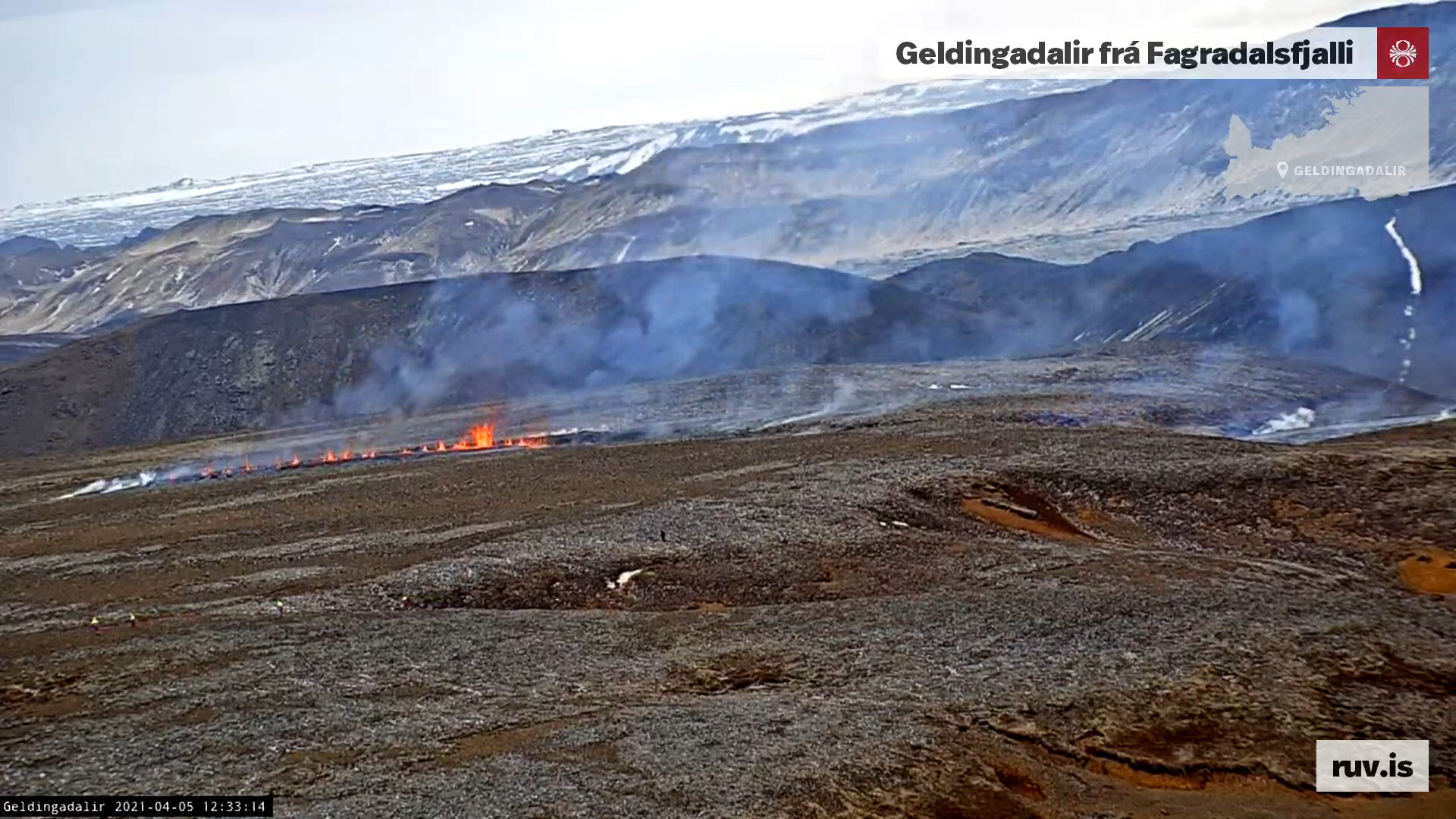
There has not been any major change since last update. In this week four new craters started erupting and I write an article about that earlier in this week for more details.
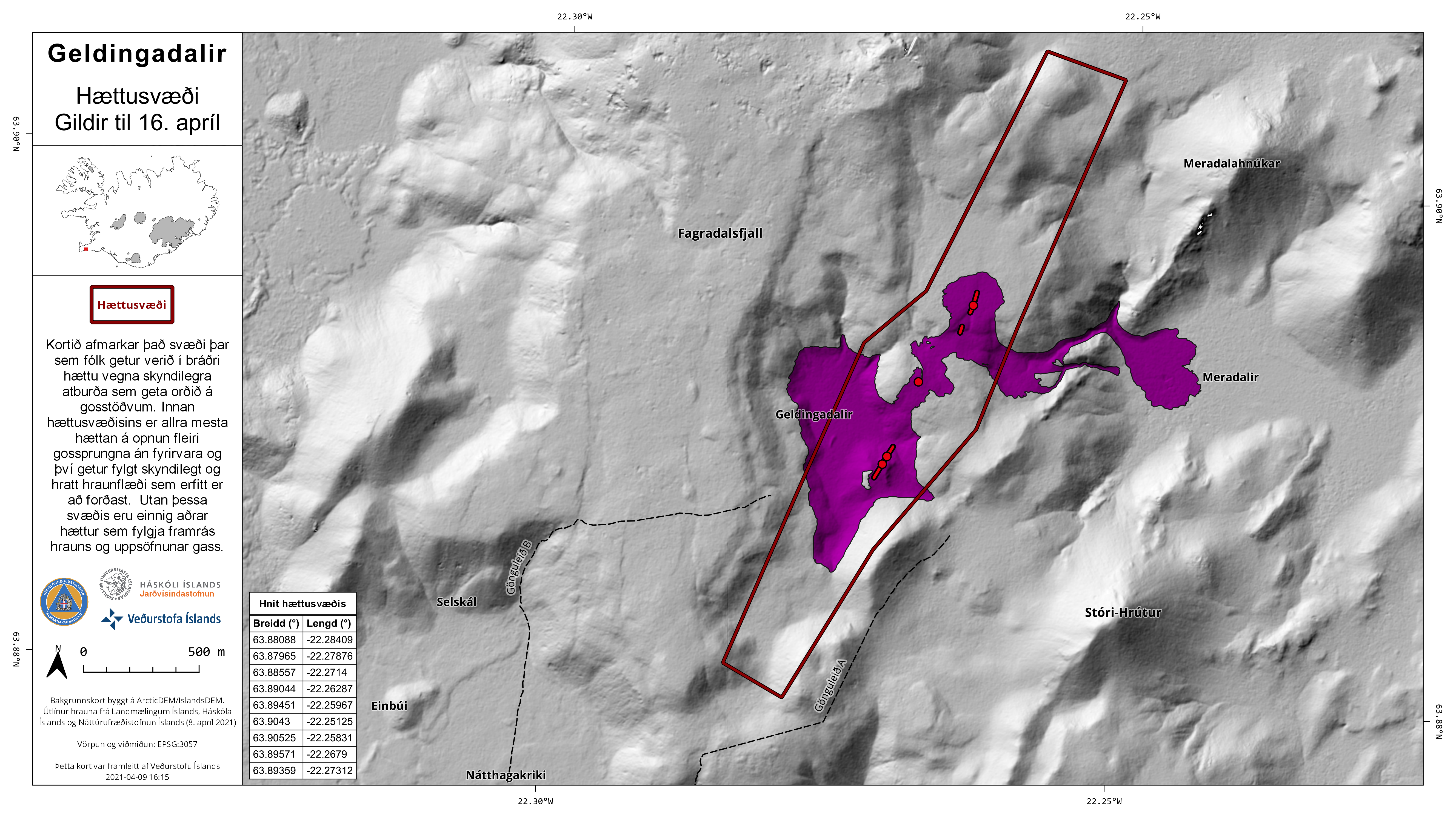
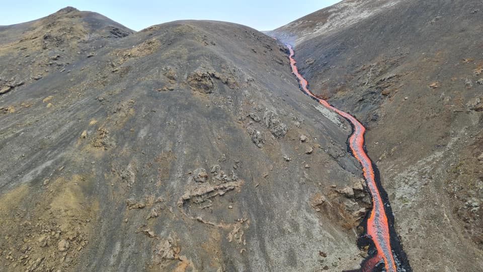
It was reported today (16-April-2021) that lava has now started to flow outside of Geldingadalir and to the east. This lava is now flowing over a walking path that people used to get close to the eruption. Getting close to the eruption might not be possible any more. There is also a chance that lava is going to is going to flow to the south of the craters more than it already has done.
Swarm of small earthquakes took place north-east in Fagradalsfjall mountain early morning around 06:00 UTC. Largest of those earthquakes had a magnitude of Mw2,8.
There is no sign of the eruption ending.
There continues to be a high risk of new vents opening up and start erupting without warning.
There are no more reports this week outside of what I did write about what was happening earlier in the week. If anything major happens I am going to post an update soon as possible.
This is a short update on the eruption in Fagradalsfjall mountain that is part of the Krýsuvík-Trölladyngja volcano system.
Yesterday (13-April-2021) the following thing happened around 09:00 UTC.
Four new crater started erupting. This did not reduce the lava output of the other craters that are erupting.
This means that now are total of eight craters erupting in the eruption in Fagradalsfjall mountain. The area is slowly being buried by fresh lava as the eruption goes on.
On Sunday 18-April-2021 it is going to be 1 month (30 days*) since the eruption in Fagradalsfjall mountain started. *This is a calendar thing, but using a website to calculate this correctly then this is the correct day using 30 day month calendar.
There continues to be high risk of new eruption fissures opening up without warning. Both north and south of the crater 1.
Gas output from the eruption has more than doubled in last few days. This is starting to create problem if wind blow the gas over populated areas.
I don’t have any more updates as is. If anything more happens I’ll update soon as I can. Since there is a risk of this eruption is going to last for a real long time, up to several years I might change my update schedule from what it is now. I’ll figure that out as the eruption continues.
This is a short article about the eruption in Fagradalsfjall mountain that is part of Krýsuvík-Trölladyngja volcano system.
This week has been busy and please read the older articles about what happened earlier in this week.
Lava output is now 50% more according to University of Iceland measurements compared to start of the eruption (19-March-2021). Gas output is also more then in start of the eruption. It has resulted in problems depending on wind direction.
There is a high risk that an eruption might start south of Geldingadalir valley eruption. There is also a high risk that new eruption is going to start north of the 5-April-2021 eruption.
There is no change in inflation in the area. It has slowed down but remains the same.
There continues to be low level earthquake activity along the dyke from Keili to Fagradalsfjall mountain.
Any change that is going to happen without warning and might not happen without any earthquake or little earthquake activity.
Next update is going to be on 16-April-2021 unless something major happens. This eruption is always changing and this weekend and next week might get interesting. If anything happens I am going to write new article soon as possible.
Update at 22:43 UTC
Icelandic Met Office released this map and press release (in Icelandic only) about the risk new fissures can open up both north and south the the current craters that are erupting. This page is updated regularly so if you are looking at this later than 9 to 10 April 2021 you might have to look for this information.
The new area that has a risk of new fissures opening up without warning. Copyright of this image belongs to Icelandic Met Office.
The map shows the area that is now at risk of new fissures opening up without warning.
Update 10-April-2021 at 15:20 UTC
Around 03:14 UTC on 10-April-2021 fissure number 4 did open up between fissure number 2 (5-April-2021) and fissure number 3. The eruption from this crater doesn’t seem to be large but it did happen under a new lava that had flowed over that same area few days before from fissure 2. In fissure/crater 1 the amount of erupting lava did drop a little just before the new eruption.
I am noticing that it seems new fissures are opening up more frequently then before. This seems to have changed after opening up of fissure 3.
Timeline of fissure openings so far.
1st fissure 19-March-2021
2nd fissure opened 5-April-2021
3rd fissure opened 7-April-2021
4th fissure opened 10-April-2021
Time period between new fissures opening up currently seems to be 3 to 4 days. I suspect that this is going to change soon and it is possible that new fissure that opens up might get larger as the eruption goes on. There seems to be phase in this eruption that is happening in Fagradalsfjall mountain. I am not perfectly sure what that phase is now since I’ve never seen this before and I don’t have any data on this type of eruption behaviour from other volcanoes outside of Iceland. That I know of.
This is a short update and second update for 6-April-2021 for Fagradalsfjall mountain that is part of Krýsuvík-Trölladyngju volcano system.
During the night a new fissure was discovered between the new eruption and the old eruption. The fissure is about 150 meters long and there is hot air coming up from it.
There are reports of a new fissure north of the new eruption and land has been sinking down at that location. No other changes have been reported at the writing of this article.
The lava going down into Meradalir valley slows down once it is there because it cools down quickly once it is there. There is a lava river going down in the Meradalir valley and that lava is moving quickly.
It is now estimated that this is a start of a long volcano activity period on Reykjanes peninsula that is going to last for centuries with breaks of 10 to 20 years between active periods of 30 to 50 years.
The situation is currently changes often during the day and the night and the risk of a new eruptions starting without any warning is now extremely high.
Donations
Please remember to support my work with donations if you can. Thanks for the support. 🙂
This is a short update on the eruption in Fagradalsfjall mountain as it is part of Krýsuvík-Trölladyngja volcano.
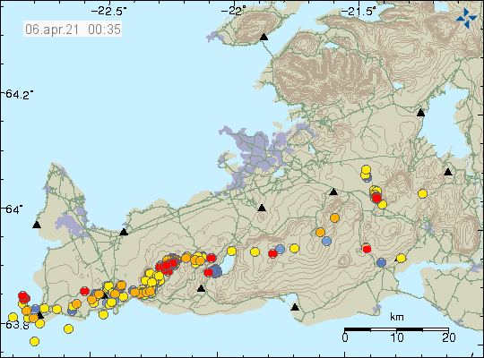
There has been a slight increase in micro-earthquake activity along the dyke after the new fissures opened up in Fagradalsfjall mountain. Most of them are interestingly forced on a area close to Keilir mountain.
The earthquake activity on the Reykjanes peninsula. Copyright of this image belongs to Icelandic Met Office.
It has been reported that lava flow from the new and old eruption site is now more than what was most at the old eruption site (Geldingadalir valley). It is now estimated to be total 10m3/second.
Craters are building up at the new eruption site. That might change the lava flow long term and there is a risk that it is going to flow towards Geldingadalir valley when that change in lava flow happens.
There is a high risk of new fissures opening up both north and south of Geldingadalir valley (1st eruption) and north of Fagradalsfjall mountain eruption (2nd eruption).
Lava is now flowing into Meradalir valley. That valley is far larger then Geldingadalir valley and won’t be filled up easily. There seems to be more water in this valley and that might result in lava explosions if the lava gets that far down into the valley.
Currently there are no other new information that I can find. Next update should be on Friday 9th April 2021 unless something major happens.
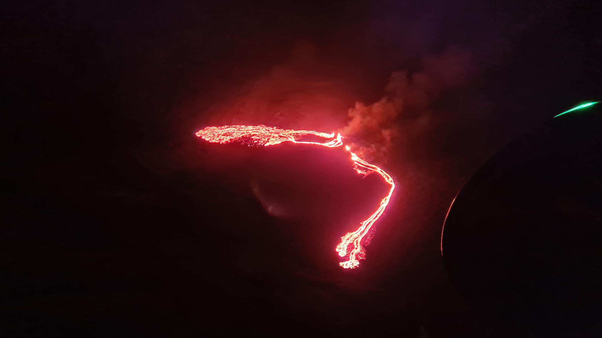
New fissure started to open up at around 11:37 UTC on 5-April-2021 when a magnitude Mw1,5 earthquake (most likely) took place in Fagradalsfjall mountain. The new fissure is expanding and but I am now estimating that the current length of the new fissure is 1,2 km based on Rúv News web camera view. The new fissure is north-east of the earlier eruption in Geldingadalir valley any.
The new fissure opening up. Copyright of this image belongs to Rúv. From Rúv web camera.
I’ll post update about this later today when I know more.
Update at 16:29 UTC
The larger fissure is around 300 meters long according to reports. Part of it seems to be under its own lava flow based on what I am seeing on new videos of the fissure. The second fissure is about 10 to 30 meters long. There is also a one single eruption vent in the area just outside of the fissure areas. The lava flow is going into Meradalir below the new fissures. It might soon go into a what seems to be a lake or a dried up lake in that valley that is a lot larger and deeper than Geldingadalir valley that is now full of lava. The eruption in the original craters continues but at lot less energy levels than before. This might only be temporary change but it is impossible to know for sure what is going to happen.
Next update is going to be again in few hours as this situation develops.
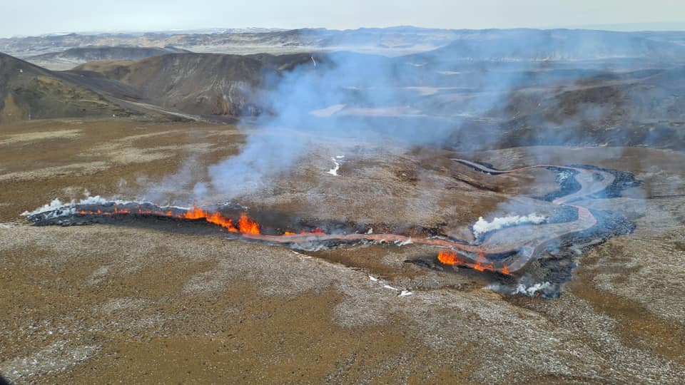
Pictures are from Department of Civil Protection and Emergency Management.
The eruption from a helicopter as seen today. Picture is from Department of Civil Protection and Emergency Management. Free to use.The lava river into Meradalir valley. Picture is from Department of Civil Protection and Emergency Management. The pictures is free to use.
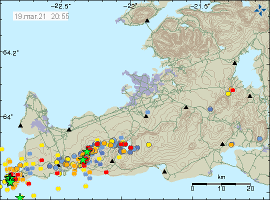
During the night 4-April-2021 at 02:04 UTC an earthquake with magnitude Mw3,0 at 5,7 km depth took place 1,5 km south-west of Keilir mountain. This earthquake was felt in Reykjavík area and outside of it. Based on the earthquake location it looks like it is located in the dyke or close to it. This is part of the Krýsuvík-Trölladyngja volcano.
Earthquake activity on Reykjanes peninsula. Copyright of this image belongs to Icelandic Met Office.
Along the magma dyke there seems to be forming focused points of earthquake activity. Currently I am seeing two location. The first location is around the eruption in Geldingadalir valley (former) and the second location that seems to be forming is just south of Keilir mountain. It has been my experience during the eruptions over the last few years that this type of earthquake activity might suggests that new location where eruptions might take place based on this earthquake activity. It is impossible to know if anything is going to happen. There is no change in GPS data since the eruption started. The GPS data can be viewed here.
This information is going to get outdated quickly. This article covers Krýsuvík-Trölladyngja volcano. This article is written on 21-March-2021 at at 00:40 UTC.
This eruption is tiny. The amount of magma erupted is now around 0.02km3 but this number might not be fully accurate since I’ve not seen any published number about of volume of lava erupted so far.
This is unconfirmed but it is possible that an new fissure opened up under the lava field next to the hill side (seen on the web camera, this is on the left side).
The current erupting fissure is now about 200 meters long and might be getting shorter.
Earthquake activity has almost stopped at the writing of this article.
This eruption might only last 1 to 3 days before it stops.
There is no sign of deflation in the GPS data at the writing of this article.
There are no other reports about this eruption at current time. This might change without warning.
Beint vefstreymi af eldgosinu – Vogastapi (Rúv.is) – Added 22-March-2021. View from a distance. Should show a red glow from the eruption if the weather isn’t too bad. – This web camera is no longer active!
Update at 15:28 UTC – One side of the main crater collapses
Here is a video of the main crater collapse on one side and give lava a new path for short period of time. At the writing of this update that path for the lava has closed down again.
Kvikustreymið braut sér nýja leið (Rúv.is) – This is a new video of the crater collapse that took place at 14:20 today (21-March-2021).
Article updated at 15:29 UTC. New information added. Article updated at 21:21 UTC. New information added. Article updated at 03:06 UTC on 22-March-2021. Web camera added.
em>Article updated at 16:34 UTC on 22-March-2021. Web camera has been removed by Rúv – comment added to that web camera.
This article is going to go get updated soon as possible or a new article is going to be written. This information is going to get outdated quickly. This is Krýsuvík-Trölladyngja volcano.
This volcano eruption seems to have started without any earthquake activity or major harmonic tremor as of writing of this article. More information later this evening.
Update at 22:46 UTC
Here is a web camera link from Rúv. It might work. But all the web cameras are getting heavy traffic now.
Update 22:56 UTC
This is the possible location of the eruption based on satellite images of the area. This is in eastern side of Fagradalsfjall mountain. This is from Icelandic Met Office.
Update at 23:13 UTC
This the first picture of the eruption. The fissure is about 200 meters long at the writing of this article. Picture is from Icelandic Met Office.
Update 00:05 UTC on 20-March-2021
Video of the eruption. Video from Icelandic Met Office. Downloaded from Twitter.
Update at 00:56 UTC on 20-March-2021
Here is a new video of the eruption on Rúv website.
Title of the article was also fixed.
This is a short article that because the situation can change without warning and article is written on 19-March-2021 at 21:07 UTC. There have been updates to names used and now Krýsuvík-Trölladyngja name is used by Global Volcanism Program and Icelandic Met Office. Suggesting that the magma that is about to erupt has its origin in Krýsuvík volcano system eat of current centre of activity. This sometimes happens in Iceland when magma travels long distances deep underground.
Earthquake activity in Krýsuvík-Trölladyngja volcano system. Copyright of this image belongs to Icelandic Met Office.
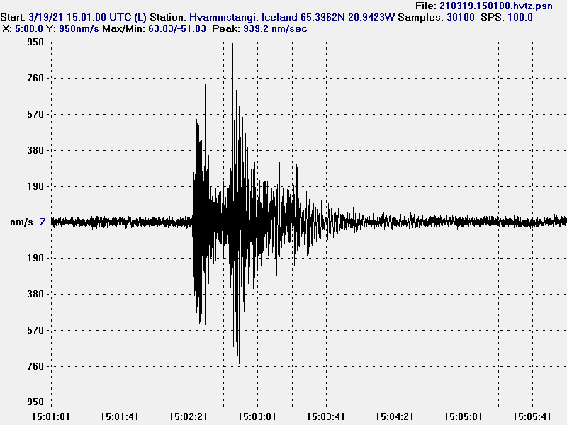
Today at 15:01 an earthquake took place with magnitude of Mw3,1. This earthquake has in my view clear signs of magma movement close to the surface as the depth of this earthquake was just 0,1 km (100 meter).
A magnitude Mw3,1 earthquake that took place today at 15:01 UTC.
This earthquake strongly suggests that magma created it at shallow depth. It has not yet resulted in an eruption but it is a question if this the final sign before an eruption happens. The current quiet time might last up to 2 months but it is impossible to know for sure.
Cookie acceptance
We use cookies on our website to give you the most relevant experience by remembering your preferences and repeat visits. By clicking “Accept”, you consent to the use of ALL the cookies.
This website uses cookies to improve your experience while you navigate through the website. Out of these cookies, the cookies that are categorized as necessary are stored on your browser as they are essential for the working of basic functionalities of the website. We also use third-party cookies that help us analyze and understand how you use this website. These cookies will be stored in your browser only with your consent. You also have the option to opt-out of these cookies. But opting out of some of these cookies may have an effect on your browsing experience.
Necessary cookies are absolutely essential for the website to function properly. This category only includes cookies that ensures basic functionalities and security features of the website. These cookies do not store any personal information.
Functional cookies help to perform certain functionalities like sharing the content of the website on social media platforms, collect feedbacks, and other third-party features.
Performance cookies are used to understand and analyze the key performance indexes of the website which helps in delivering a better user experience for the visitors.
Analytical cookies are used to understand how visitors interact with the website. These cookies help provide information on metrics the number of visitors, bounce rate, traffic source, etc.
Advertisement cookies are used to provide visitors with relevant ads and marketing campaigns. These cookies track visitors across websites and collect information to provide customized ads.