Yesterday (10. February 2023) at 16:25 UTC an earthquake with magnitude of Mw3,1 took place around 41 km south of Kolbeinsey island.
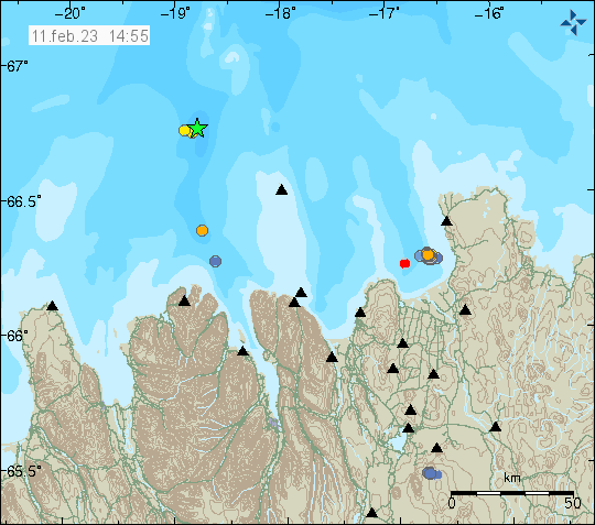
This earthquake was far from any populated areas of Iceland and was not felt for this reason.

Volcano and earthquake activity in Iceland
Yesterday (10. February 2023) at 16:25 UTC an earthquake with magnitude of Mw3,1 took place around 41 km south of Kolbeinsey island.

This earthquake was far from any populated areas of Iceland and was not felt for this reason.
This earthquake swarm is ongoing at the writing of this article and information can change without warning. The largest earthquake recorded by automatic magnitude of Mw3,7 at the writing of this article. Around 30 to 40 earthquakes have happened so far, but that number might change quickly. This earthquake activity has some signs that it might be happening because of magma intrusion in the area, out in the ocean but signals are not clear.
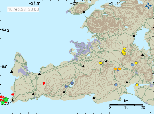
This earthquake activity is in the volcano Reykjanes, that volcano goes into the ocean and is on dry land. Making possible future eruptions both explosive and flowing magma at the same time. To date, Reykjanes volcano only has had earthquake swarms and no eruption. When that is going to change is impossible to know.
Today (7. February 2023) an small earthquake swarm took place. This earthquake swarm started at 11:21 UTC with a magnitude Mw3,2 earthquake and lasted until 12:05 UTC. Other earthquakes were smaller in magnitude.
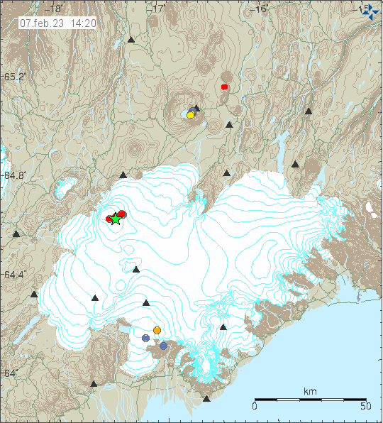
This shows that Bárðarbunga volcano continues to inflate at high rate. Based on what happened before the eruption in 2014 to 2015 in Bárðarbunga volcano. When the earthquake stop for long time period it means Bárðarbunga volcano is ready for an eruption. While the earthquake activity happens is it is doing today, it means inflation continues in Bárðarbunga volcano.
Today (06. February 2023) at 10:24 UTC an earthquake with magnitude of Mw7,5 took place. This earthquake took place less than 12 hours after the Mw7,8 earthquake took place 50 km south of this earthquake. USGS is reporting (seen on CNN) that 10000 people might have died in this earthquakes because of were it is located. The real number might be higher. News is also reporting that 582 people have died in Syria because of this earthquakes. There is heavy aftershock activity in this area and the second largest aftershock had a magnitude of Mw6,7 at 01:28 UTC.
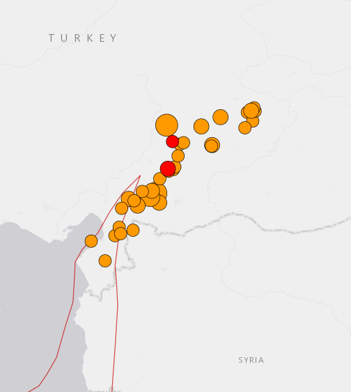
Information about the Mw7,5 earthquake can be found here at EMSC and here at USGS. Information about the Mw6,7 earthquake can be found here at EMSC website.
Update (22:38 UTC)
The magnitude Mw7,5 earthquake has been confirmed to be an aftershock by USGS.
Today (6. February 2023) at 01:17 UTC an earthquake with magnitude of Mw7,8 took place in south Turkey. Damage is to be expected in this type of earthquake. This earthquake was felt over a wide area. Because of high electric price, I’ve been unable to run my seismometer in Denmark and I did not record this earthquake for that reason. At this magnitude this earthquake was recorded all over Europe in professional and citizen science seismometers.
EMSC information can be found here and USGS information can be found here. Links can stop working without warning.
This might not be anything at the writing of this article. Since there’s little earthquake activity in Katla volcano at the moment, its well below background noise. Over the last several months I’ve noticed an slight increase in larger earthquakes in Katla volcano, this might not mean anything, but I do not remember having seen this type of pattern in earthquake activity in Katla volcano before. Currently the earthquake activity is almost none and that means that for now there’s no risk of an eruption.
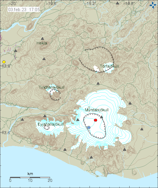
Largest earthquake today (3. February 2023) had a magnitude of Mw2,7. This is what has been happening in recent months. This one or two earthquakes that are slightly larger than what I consider normal. There’s a chance this might be normal and nothing more is going to happen, but for now, it is impossible to know for sure what is happening.
I’ve made the chose to start Iceland Geology channel. This is going to allow me to upload geology information in video format. How that is going to evolve is unclear, but I am going to work on this slowly over the next few years.
Iceland Geology YouTube channel can be found here. I have uploaded few videos, but since the channel is just recently in use I am still going trough verification process with YouTube. That limits my number of uploads until those are lifted. Since I am for now just uploading older videos that I’ve recorded in last few years.
Information for webicorders (online again from May or June) and e-mail postlist signup website are now under Iceland Geology menu option.
Yesterday (30. January 2023) had two earthquakes with magnitude Mw3,2 far off the coast on the Reykjanes ridge. Only one smaller earthquake was detected. Distance from the SIL network makes detection of smaller earthquakes is impossible or really difficult.
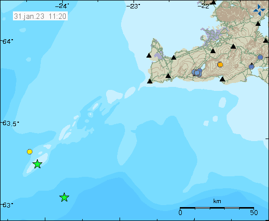
Besides this earthquake activity, it remains quiet in Iceland. Bad weather has also been blocking detection of earthquake activity for the last two weeks.
Today (30. January 2023) at 19:55 UTC (20:55 CET) an earthquake with magnitude of mb5,2 took place south of Malta in Central Mediterranean sea. According to reports to EMSC, this earthquake was felt in Malta. Damage is unlikely because of distance from populated areas. This is not the first earthquake in this area and this earthquake activity is what I consider interesting.
Since there’s a slight chance it might be volcano or magma related, but I am not sure on that because I don’t have any good knowledge of this area. There might be a volcano in this area, but for same reasons as before. I am not sure because of my lack of knowledge of this area. Maps, good as they are, don’t show any noticeable features on the ocean floor in this area.
Information about this earthquake can be found here on EMSC website.
Today (28. January 2023) an earthquake with magnitude of Mw5,9 took place in Iran, close to the border with Turkey. According to EMSC reports this earthquake was felt over a wide area. I don’t know if any damage happened, but that is likely if housing is of poor construction. Landslides might also have happened in areas closest to the earthquake.
Continue reading “Magnitude Mw5,9 earthquake in Iran, close to border with Turkey”