
A small glacier flood started from Mýrdalsjökull glacier few days ago. The most risk is from sulphur gases and other gases from the glacier flood that might be concentrated in lower areas. There is also a minor risk of the flood destroying walking path bridges in the area it goes over. This glacier flood might go into Emstruá river and there is the risk of destroying walking path bridges in the area. No other risk is expected from this minor glacier flood from Mýrdalsjökull glacier. This is a normal summer release of hydrothermal water from the glacier. Happens every other year and sometimes every year.
Minor glacier flood from western Skaftárkatlar cauldron
Few days ago a glacier flood started from western Skaftárkatlar cauldron. Due to how short time it is since last time glacier flood took place from the western cauldron a major glacier flood is not expected. No damage is also not expected from this glacier flood due to how small it is.
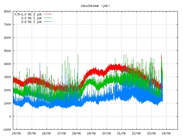
Harmonic tremor disturbance due to the glacier flood from western Skaftárkatlar cauldron. Copyright of this image belongs to Iceland Met Office.
When the water pressure is released from the hydrothermal area that powers this cauldron, a spike in harmonic tremor is normally seen on nearby SIL station. The reason for this is unclear, with leading ideas that magma moves in the hydrothermal system when the pressure drops. The image above shows such harmonic tremor spike taking place at Jökulheimar SIL station. Eruption is not expected to happen due to this glacier flood, what happens is impossible to know for sure. Normally nothing more than just harmonic tremor spike happens.
Glacier flood from Skaftárkatlar cauldrons and other updates
This is going to be a short article since I don’t have a time to write a long one.
The glacier flood from Skaftárkatlar cauldrons is mostly over. There continues to be a lot of water in rivers that were flooded, with the flood peak being at 2200 m³/s (uncorrected). Some damage has taken place on roads and few bridges, with one major bridge almost collapsing from the river eating into the river banks. A graph showing this glacier flood in realation to older glacier flood from the eastern skaftárkatlar cauldron can be found here (Icelandic news). The glacier water that did flood into a lava field (that erupted from Laki) is still on its way and is going to reappear in few days as clean water, a lot of clean water that might create problem in nearby rivers and nearby roads if any exist. I don’t know the layout of roads and such in this part of Iceland so I don’t release what type of damage might happen. Image of the largest damaged bridge can be found here (Icelandic news), there is a video in this news.
Bárðarbunga volcano
There has been a slight increase in earthquake activity in Bárðarbunga volcano this week. A magnitude 3,1 earthquake took place along with little increase in smaller earthquakes. There have also been clusters of small earthquakes been appearing in east and in south (both east and west) part of the volcano. This activity suggest that new magma is flowing into the magma chamber at depth and the pressure has increased. Maybe not to eruption levels at the moment, but that moment is getting closer as the time passes.
Earthquake activity in Bárðarbunga volcano. Copyright of this image belongs to Iceland Met Office.
North Langjökull volcano (Hveravellir)
Earlier this week an earthquake swarm took place close to Hveravellir (volcano). This earthquake swarm was not large and the largest earthquake only had the magnitude of 2,5 (or around that number. I was working when this happened and I did not have chance to check or save the data). Earthquake activity in this area has been increasing slowly for the past 10 years. It is unclear why that is happening.
The earthquake activity in Hveravellir volcano. Copyright of this image belongs to Iceland Met Office.
Western Fracture Zone
There has been for the past few days earthquake activity in WFZ. This earthquake activity appears to be taking place in a extinct volcano in this area. I don’t think that this volcano is named and I don’t know the name of the mountains at the location were the earthquake activity is taking place.
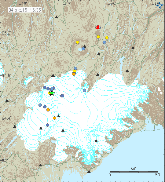
The earthquake activity in WFZ today (04-October-2015). Copyright of this image belongs to Iceland Met Office.
I do expect the earthquake activity to continue in this area for next few days. Due to how rare earthquakes are in this area there is a risk of sharp and strong activity. It might also last for a long period of time, up to weeks or months at the longest.
Donations
Please remember to support my work with donations. At the moment I’m trying to collect as much money as I can before I move back to Denmark. I am also trying to save up for a cheap new laptop so that I can write when I am traveling, in the case anything happens in Iceland. It is going to cost me 40.000,00 ISK (~280€/315USD). Currently I’m doing full workday until the end of October (when not in school). To clarify, the work is hard and they only pay legal minimal wages and overtime pay (1 – 3 hours each day).
Thanks for the support.
Glacier flood from Skaftárkatlar cauldrons in Vatnajökull glacier
Yesterday (16-June-2015) a small glacier flood started in Skaftárkatlar cauldrons in Vatnajökull glacier. The glacier flood can go up to 900m³/sec at its largest. The main risk from this glacier flood are the gases released into the air once the glacier water gets into the river, it is the advised that people stay away from the glacier rivers called Skaftá, it is also advised that people stay away from the edges of the glaciers named Skaftárjökull glacier, Tungárjökuls and Síðujökuls. It is unclear how big this glacier flood is going to be and from what cauldron is emptying, there is a good chance the cauldron that is emptying is the western one, since the eastern one empted last year and does not hold a lot of water at the moment.
Following this type of glacier flood a peak of harmonic tremor is detected from the cauldron that is emptying, it is thought that this is due to the hydrothermal vents (hot springs) that power those cauldrons start to boil when the pressure is released. There is a small chance eruption taking place in this area due to glacier flood when the pressure of the water is released, this is a chance, but it remains a small one.
Icelandic news
Skaftárhlaup líklega hafið (Rúv.is, Icelandic, Map)
Lítið Skaftárhlaup líklega hafið (Mbl.is, Icelandic)
Skaftárhlaup mjög líklega hafið (Vísir.is, Icelandic, image)
Donations
Please remember to support my work with donations or by using Amazon. Thanks for the support.
Article updated at 21:52 UTC.
Small glacier flood from Grímsfjall volcano caldera
Today (11-May-2015) a glacier flood started from Grísmfjall volcano caldera. This is not a dangerous glacier flood due to its small size. There is however a danger from sulphur gases and other gases that dissolve when the pressure is dropped on the water. If people get too close to the Gígukvísl glacier river where the flood comes from Vatnajökull glacier they risk a damage to there eyes and lungs due to burning effects from the gases in the air.
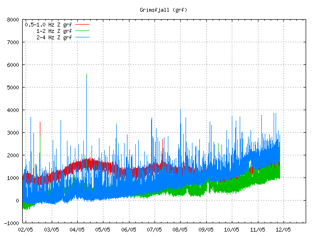
Increased harmonic tremor from Grímsfjall volcano. Copyright of this image belongs to Icelandic Met Office.
There is now a increased harmonic tremor from Grímsfjall volcano. It is not clear why that is, it is either the glacier flood or hydrothermal vents boiling at the bottom of the lake due to the sudden pressure release on them. There is nothing suggesting that an eruption is going to follow this glacier flood from Grímsfjall volcano. Last glacier flood took place in 2014.
Icelandic News
Lítið hlaup í Gígjukvísl (Rúv.is, Icelandic)
Possible minor eruption in Bárðarbunga volcano caldera
It appears that at 21:22 UTC (on 29-January-2015) a possible minor eruption might have taken place somewhere along the Bárðarbunga volcano caldera rim or in it slopes. I don’t have any confirmation yet, but this is what the tremor data suggest at the moment. This minor eruption appears to have lasted around 30 – 55 minutes in total. If there was an high amount of glacier melt the glacier water is going to start appearing in Jökulsá á fjöllum or other glacier rivers that come from Vatnajökull in next 8 – 18 hours. Depending on the router the water takes. I don’t know where it is going to go, but the highest chance is that it is going to appear in Jökulsá á fjöllum glacier river. This minor eruption was followed by a minor earthquake swarm, the largest earthquake in that swarm had the magnitude of ~4,5 according to automatic results.
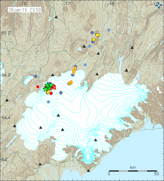
The earthquake activity that followed this harmonic tremor (the red dots). Copyright of this image belongs to Icelandic Met Office.
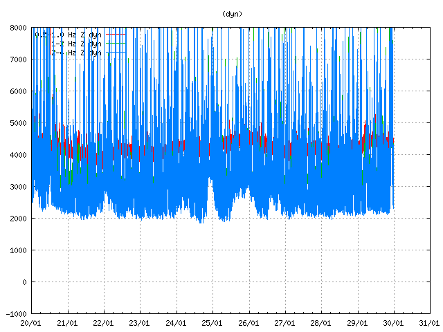
The harmonic tremor spike can be seen on Dynjuháls SIL station at the end of the blue line, where it spikes up. Copyright of this image belongs to Icelandic Met Office.
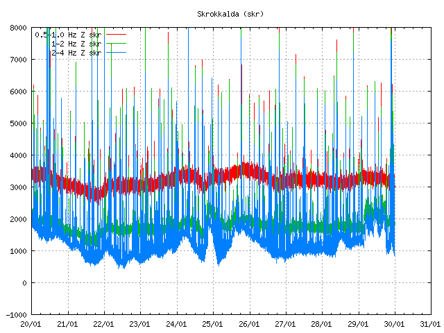
The harmonic tremor spike as it appears on the SIL station on Skrokkalda. The spike is clear based on other activity that appears clearly on this SIL station (earthquakes). Copyright of this image belongs to Icelandic Met Office.
 High resolution image of the harmonic tremor on Dyngjuháls SIL station. This is the signature of eruption under the glacier. Even if it was just a small one. Copyright of this image belongs to Icelandic Met Office.
If anything more happens I am going to post update soon as possible. I am going to write about the earthquake swarm on the Reykjanes Ridge tomorrow.
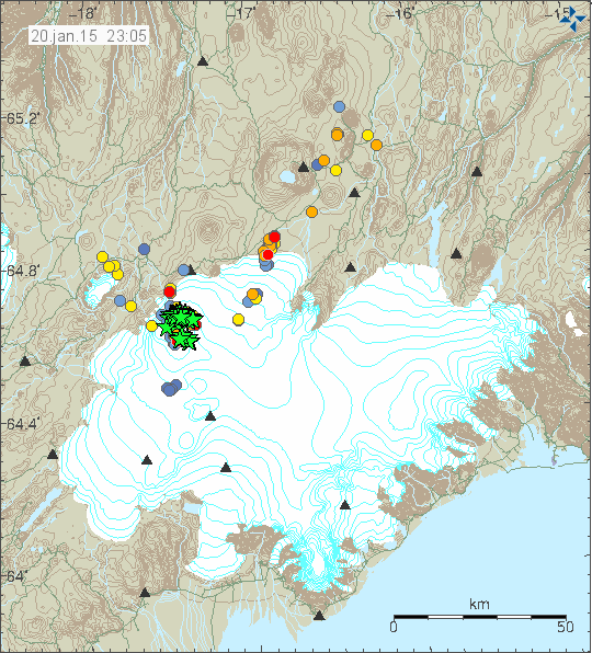
Bárðarbunga volcano update for 20-January-2015
The eruption in Bárðarbunga volcano (Holuhraun). Not much change has been reported in past few days. Currently the northern side of the eruption crater has not collapsed so far, but based on web cameras it appears that the activity is increasing in the north part of the crater. The lava field is now around 85 km² in size. The amount of SO2 that comes up during the day is around 10.000 – 30.000 tons of it.
Earthquake activity in Bárðarbunga volcano for the last 48 hours. Copyright of this image belongs to Icelandic Met Office.
Earthquake activity has been increasing in Bárðarbunga volcano for the past 24 hours. There is now a considerable higher number of earthquakes with magnitude 3,0 and higher taking place. I don’t know why this is happening. Either something is changing in Bárðarbunga volcano or something in the crust is giving away. At the moment it is impossible to know for sure what is going on. It is also impossible to know when that might become clear what is going on.
Other Bárðarbunga volcano related
Landsnet the company that runs the electric grid in Iceland is now moving electric poles in few areas, in order to avoid damage to the electric grid due to a eruption under the glacier in Bárðarbunga volcano and the glacier flood that follows it. They are also performing changes close to dams in the path of possible glacier flood from Vatnajökull glacier. This is done in order to try and protect those structures much as possible from damage if an glacier flood happens.
Scientist working in the close proximity of the eruption in Holuhraun and that have been staying there for a long time have noticed that they suffer from chronic cough. Once they left the eruption area for Christmas break the cough stopped, since at that time they got out of the polluted area.
Icelandic news
Háspennusmastur fært vegna flóðahættu (Rúv.is, Icelandic, video)
Vísindamenn með krónískan hósta vegna gasmengunar (Vísir.is, Icelandic)
Minor schedule update
I’ve moved the second update during the week to Friday. Since that allow more days to pass during the regular eruption phase in Holuhraun.
Moving PayPal to Denmark (again)
I am going to be moving PayPal to Denmark soon (2 – 4 days). I do this since there are problems with having PayPal in Iceland. Since I am going to be moving back to Denmark in few years anyway (Since I really integrating well into Danish society, even if I was not fully integrated when I moved back to Iceland due to my current money problems).
Article updated at 01:57 UTC on 21-January-2015
Article updated at 13:21 UTC on 21-January-2015
Bárðarbunga volcano update for 27-October-2014
During the weekend activity in Bárðarbunga volcano was in the same manner as it has been for the past two months. Largest earthquakes during the weekend had the magnitude of 5,2 and 5,3. Pollution was a big problem south of the eruption in Holuhraun and new record was set for SO2 pollution in populated areas in Iceland. The pollution levels did go up to 21.000 μg/m3 when they where the highest during the weekend. A emergency was declared for Höfn in Hornafirði when the worst pollution did go over the area. Currently there is a little bit less pollution, but air quality is poor in parts of south Iceland at the moment.
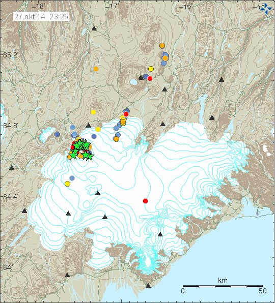
Earthquake activity in Bárðarbunga volcano for the last 48 hours. Copyright of this image belongs to Icelandic Met Office.
Largest earthquake on 27-October-2014 had the magnitude of 5,3 and happened in the south-east part of the caldera. Since it has been quiet in terms of earthquake activity. According to Icelandic Met Office this is normal and has happened before. Subsidence of the caldera happens without any earthquake activity most of the time. According to Icelandic Met Office and others (pdf file here), the caldera has now dropped some 40 meters. New cauldrons have been forming along the caldera rim and older ones (that I did not know about until today) have been getting deeper according to measurements from Friday (24-October-2014). The new and older cauldrons appear clearly on images that can be found here (text is in Icelandic). GPS data is showing minor inflation in the dyke that is currently erupting, suggesting that more magma is flowing into it then is erupting from it.
If any melt is happening in the caldera it is not appearing on the glacier yet. As for the water, it just goes down. Rock inside volcanoes leaks, a lot, so it is easy for the water to go into the crust. It doesn’t have to go anywhere else in small amounts that might be melting if the crust has warmed up enough to do so. Currently there are no evidence for that taking place, but with 850 meters of glacier on top of it is difficult to be sure. There are no other news about the eruption that I know of at the moment.
Donations: Please remember to donate or support my work if you buy from Amazon to due so trough the banners I have here. Thanks for the support.
Bárðarbunga volcano Friday update on 24-October-2014
This is the Friday update for Bárðarbunga volcano eruption.
During the past 48 hours total (when this is written) of 69 earthquakes with magnitude of larger than 3,0 have happened in Bárðarbunga volcano. Total number of earthquakes in that same time period is 286 earthquakes (when this is written). Since yesterday it appears that earthquake activity is increasing in Bárðarbunga volcano at the moment, there is minor fluctuation in activity every few hours. I do not know why that is happening.
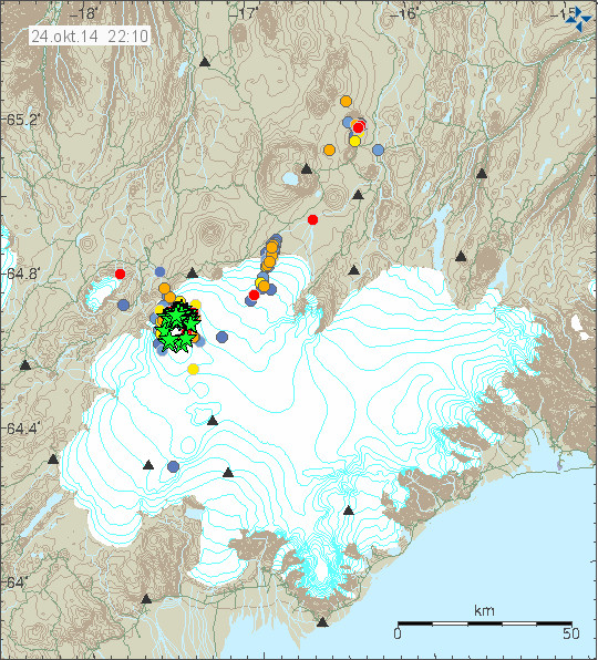
Earthquake activity in Bárðarbunga volcano. Green stars are earthquakes larger than magnitude 3,0. Copyright of this image belongs to Icelandic Met Office.
Most of the earthquake activity is taking place in North-east part of Bárðarbunga volcano caldera rim. Few to no earthquakes are happening in the centre of the caldera. Currently the caldera continues to lower around 30 – 40cm/day according to latest news from Icelandic Met Office. Far as I know the eruption in Holuhraun continues at the same rate as yesterday with no major change taking place. Some minor earthquake activity has been taking place along the dyke for the past 48 hours. Other then this I don’t have heard any other news about current status. I am currently looking into few details about what might be happening, but I am as always waiting to see what nature does next.
Added: I forgot to mention that Holuhraun lava field is now 63 square kilometres in size. It doesn’t grow in size today as fast as it used to do. It might however be adding volume rather then size at the moment, with occasional break in the lava rim allowing it to expand slowly.
Donations: Please remember to support my work by donating or by using Amazon to shop. Please just choose your region in Amazon Webstore site if I don’t have banner from you area up. Thanks for the support.
Other: Next week I move to a different schedule since current phase is not changing a lot between days. This means that updates are going to be on following days. Monday, Wednesday, Friday. Unless there is something new happening then I am going to update right away with newest information. I never know what is going to happen so I don’t keep tight schedule on updates.
Article updated at 22:51 UTC.
Bárðarbunga volcano update for 15-October-2014
Far as I know there has not been a big change in the activity in Bárðarbunga volcano today (15-October-2014). Largest earthquake today had the magnitude of 5,4 and was felt in Akureyri. When the magnitude 5,4 earthquake happened the caldera dropped 15 cm in one go according to the GPS measurements in its centre. Over the past two days earthquake activity has been increasing in Bárðarbunga volcano and along the dyke that is erupting in Holuhraun. After the largest earthquake today the earthquake activity appears to have dropped a little.
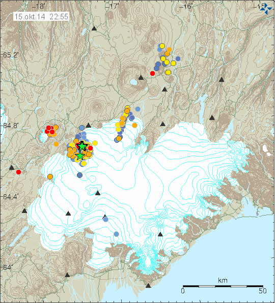
The earthquake activity today in Bárðarbunga volcano. Copyright of this image belongs to Icelandic Met Office.
Other then this I don’t think there is anything more in news of activity in Bárðarbunga volcano. Since day to day activity remains the same. Tungafellsjökull volcano continues to show earthquake activity following the stress changes that are now taking place in Bárðarbunga volcano. I still think no eruption is going to take place in that volcano [Tungafellsjökull volcano], at least as things stand at the moment.
Those how are interested in hearing the magnitude 5,4 earthquake that happened today. It is possible to do so in this two audio files that I did convert from my earthquake data earlier. This is how my geophones at Böðvarshólar (bhrz) and Heklubyggð (hkbz) “hear” the earthquake. Each audio file is only 2 seconds long. The sound from Heklubyggð is louder since the earthquake signal is stronger there. Both audio files are released under Creative Commons Licence. Please see CC Licence page for more details.
Böðvarshólar geophone
141015.111600.bhrzZ
Heklubyggð geophone
141015.111607.hkbzZ