Strong earthquake activity on Kolbeinsey ridge (26-June-2017)

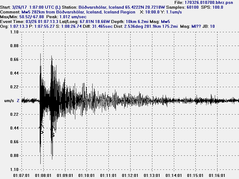
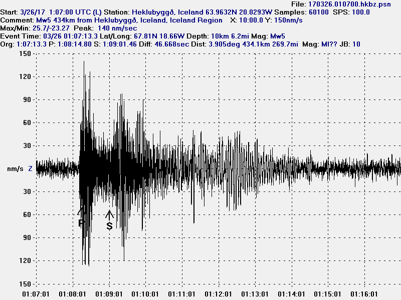
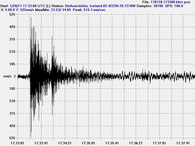
During the night of 26-June-2017 an earthquake swarm started north of Kolbeinsey island on Kolbeinsey ridge. This earthquake swarm is located around 355 km north of Siglufjörður village making it difficult to know for sure what is going on there. Largest earthquake so far had the magnitude of mb4,4 (EMSC Information), at the moment this is the only earthquake to register with EMSC. Total of 20 earthquakes have been over magnitude 3,0 so far, as this earthquake swarm is ongoing that number is going to change in the next few hours.


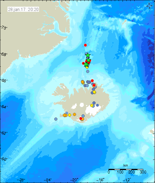
The earthquake activity on Kolbeinsey ridge (green stars). Copyright of this image belongs to Icelandic Met Office.

I don’t know yet if there is any eruption at this location. At this distance the SIL network might not register the harmonic tremor of a small eruption or dyke intrusion. Ocean depth at this location is 2 – 3 km and that rules out any major signs appearing on the surface of the ocean. Currently there seems to be a break between earthquake swarms, that is just how it appears as the SIL network is not able to detect any small earthquakes at the distance of 355 km (about) and that means only minority of earthquakes is being recorded. There is also a possibility that this is just a normal rift earthquake activity that happens at this location, the area I think is is a rift valley, but this being a dyke or an volcano eruption can’t be ruled out.

This article is going to be updated if needed.

Donations

Please remember to support my work with donations. It helps keeping me afloat financially. Thanks for the support. 🙂

Earthquake swarm in Kolbeinsey island

Yesterday (24-May-2017) and today (during the night of 25-May-2017) there was an earthquake swarm in Kolbeinsey island. Largest earthquakes had the magnitude of 3,6 (x2) and one magnitude 3,5 earthquake took place. Other earthquakes where smaller in magnitude. No harmonic tremor where detected during this activity, that does not rule out that this activity is due to dyke intrusion taking place in Kolbeinsey island. It just didn’t reach the surface this time. Kolbeinsey island is far away from the SIL network, with the closest station being in Grímsey island (~25 km) with other SIL station at ~60 km distance. If an eruption starts in Kolbeinsey Island, a harmonic tremor signal is going to appear in Grímsey island SIL station.


Green star mark the area where the earthquake swarm took place in Kolbeinsey island. Copyright of this image belongs to Icelandic Met Office.

Last eruption in this area took place in the year 1755, but that eruption might not actually have been in Kolbeinsey Island, but in a other unnamed volcano north of it (where is not known). Last confirmed eruption in Kolbeinsey island took place in the year 1372, it was closer to land somewhere north-west of Grímsey island (suggesting that fissure swarm of Kolbeinsey island comes close to Grímsey island).

At the moment the activity has quieted down and no earthquakes are being detected by the SIL network.

Donations

Please remember to support my work with donations. Thanks for the support. 🙂

Magnitude 4,5 earthquake on Reykjanes ridge during the night

During the night of 10-April-2017 at around 03:39 a magnitude 4,5 earthquake happened and started a earthquake swarm at same location, total number of recorded earthquakes is around 71 but that number is not confirmed as of yet. There is also a good chance a few magnitude 3,0 earthquakes happened, but this earthquake swarm has not been reviewed by Icelandic Met Office as of yet (I don’t know why it’s slow today).


The earthquake swarm as it appears on Icelandic Met Office maps, green star is the location of the magnitude 4,5 earthquake. Copyright of this image belongs to Icelandic Met Office.


The earthquake as it appeared on my geophone in Heklubyggð. This image is under Creative Commons licence. Please see CC licence for more details.


The earthquake as it appeared on my geophone in Heklubyggð. This image is under Creative Commons licence. Please see CC licence for more details.

This appears to be a normal tectonic earthquake in the rift valley that is at this location. No change was observed in the harmonic tremor, that means there was no magma movement during this activity. Based on earlier earthquake behaviour in this area, there is a good chance that new earthquake swarm is going to happen in this area after few days or at most weeks before this area going quiet again.

Donations

Please remember to support my work with donation. It helps me keeping this website and my self going and to do this job. Thanks for the support. 🙂

Strong earthquake swarm 80 km north of Kolbeinsey Island

During the night of 26-March-2017 there was an strong earthquake swarm about 80 km north of Kolbeinsey Island. This is around 250 km from the coast in north Iceland. It is not clear what is happening in this location, since this area has been seeing higher than usual earthquake activity in recent months. This is the largest earthquake swarm so far to take place.


The earthquake swarm as it appears on Icelandic Met Office maps. Green stars are earthquakes with magnitude above 3,0. Copyright of this image belongs to Icelandic Met Office.

Largest earthquakes in this swarm had the following magnitudes. Magnitude 4,6 (EMSC Information here), magnitude 5,0 (EMSC information here), magnitude 4,8 (EMSC information here). The largest earthquakes where not felt due to distance from the coast. It is not possible due to distance to see if there is an eruption taking place at this location. All harmonic tremor get lost due to distance from nearest SIL station. A really large eruption might slightly appear on tremor plot on Icelandic Met Office website, at the moment that has not happened.


The magnitude 5,0 earthquake as it appeared on my geophone in Böðvarshólar. This image is under Creative Commons Licence, please see CC licence for more details.


The magnitude 5,0 earthquake as it appeared on my geophone in Heklubyggð. This image is under Creative Commons Licence, please see CC licence for more details.

It is difficult to know if an earthquake activity is continuing in this area or not. Since the distance from nearest SIL stations does not allow for micro-earthquakes to be detected properly or at all.

Donations

Please remember to donate to help me keeping this website up and running and allow me to buy food (since I need that to write). Thanks for the support. 🙂

Continued and strong earthquake activity north of Kolbeinsey Island

For the past few weeks something has been going on in the deep ocean far north of Kolbeinsey Island. The area north of Kolbeinsey Island has been having strong earthquake swarms for several weeks now, what is creating them is less clear.


The earthquake activity north of Kolbeinsey Island (blue dots). Copyright of this image belongs to Icelandic Met Office.

All magnitudes are under-estimated at this location. I managed to record the last earthquake swarm (largest earthquakes) and it was clear by this activity that something was going on. Five earthquakes that where at least magnitude 3,2 (estimate) took place in the space of 4 – 8 minutes. This where only the earthquakes that I was able to record, distance from my geophone to this area is ~230 km at shortest distance. Making it difficult for me to record earthquakes on my simple geophone. Icelandic Met Office SIL network is not having much better luck recording earthquakes at this location, due to distance the SIL network underestimates the magnitude and location of the earthquakes has higher than normal error margins (up to several dozen of km at most).

There is a possibility that an eruption is taking place at this location now. There was a possible eruption or dyke injection at this location in October of the year 1999, the Global Volcanism Program report on that activity can be found here.

Strong earthquake activity on Kolbeinsey Ridge

Yesterday (27.01.2017) and today (28.01.2017) has seen some strong earthquake activity on Kolbeinsey Ridge. Largest earthquake in this swarm had the magnitude of Mb4,6 according to EMSC (information here). This area, or area close to it possibly had a dike injection or an eruption in the year 1999. That was however never confirmed.


The earthquake swarm on Kolbeinsey Ridge. Green stars show earthquakes with magnitude above 3,0. Copyright of this image belongs to Icelandic Met Office.


The Mb4,6 earthquake as it appeared on my geophone in Böðvarshólar. This image is under Creative Commons Licence, please see CC licence website for more information.

There have been around 5 earthquakes with magnitude above 3,0, I don’t know exact numbers of earthquakes with magnitude around and above 3,0. Due the distance of this earthquake swarm from the SIL network it is difficult for Icelandic Met Office to estimate the numbers and magnitudes of the earthquakes that happen. The distance was around 85 km from Kolbeinsey Island and around 160 km from Kolbeinsey Island. It does appear that two earthquake swarm took place in this area for the last 24 hours, but not much else is known at the moment. This activity is currently ongoing at the moment (I think).

Donations

Please remember to support my work with donations. Thanks for the support. 🙂