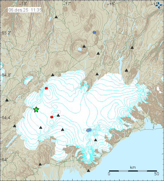
Today (06-December 2025) at 10:10 and 10:13 UTC two earthquake with magnitude of Mw3,1 and Mw4,0 took place in Hamarinn volcano. This was followed by few smaller earthquakes in the same area.
Two green stars in Hamarinn volcano. Copyright of this image belongs to Icelandic Met Office.
No other activity has happened following this earthquake activity. There has not been any change in harmonic tremor levels. I am not expecting more activity at the writing of this article.
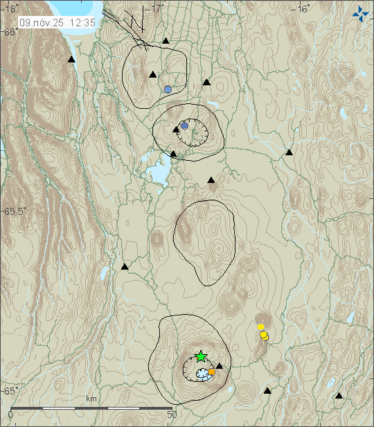
A magnitude Mw3,5 earthquake took place in Askja volcano today (9-November 2025) at 09:39 UTC. This was a single earthquake with no aftershocks. It is unlikley that more earthquakes are going to happen following this earthquake.
Earthquake activity in Askja volcano. Copyright of this image belongs to Icelandic Met Office.
There has been some inflation in Askja volcano in recent years. It is my view that that inflation is not going to result in a eruption for the next few decades. That might change if the situation changes in Askja volcano. At the current time, that seems unlikely to happen.
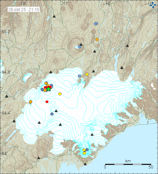
Today (29-October 2025) at 16:46 UTC an strong earthquake took place in Bárðarbunga volcano. This earthquake had a magnitude of Mw5,4. It was not felt according to news. This earthquake is the result of inflation that is happening in Bárðarbunga volcano and has been since its eruption ended in the year 2015.
Green star showing the earthquake activity in Bárðarbunga volcano. Copyright of this image belongs to Icelandic Met Office.
There was some aftershock activity, but it has been minimal. Currently there are no signs of an eruption is about to start in Bárðarbunga volcano.
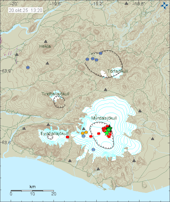
This morning on 20-October 2025 an strong earthquake swarm started in Katla volcano. Strongest earthquake so far had a magnitude of Mw4,5. It was most likely felt in nearby populated areas. Several earthquakes with magnitude above Mw3,0 also took place. This earthquake swarm is ongoing, but it happens in waves and at the writing of this article there is a quiet period happening.
Earthquake activity in Katla volcano. Copyright of this image belongs to Icelandic Met Office.
At the moment there has not been any signs of magma movement. That might change without warning. There also not been any change in glacier water from Mýrdalsjökull glacier. That only show up after 4 to 8 hours, since it takes time for the glacier water to travel to the glacier rivers from Mýrdalsjökull glacier. If anything more important happens. I’ll post a new update on what is going on.
Today (18. September 2025) at 00:04 UTC an earthquake with the magnitude of Mw3,6 took place in Hamarinn volcano, that is south of Bárðarbunga volcano.A small aftershock took place soon after the largest earthquake. There are no signs that an eruption is about to happen. Last year this area also had an earthquake, but a bit smaller one.
Earthquake in Hamarinn volcano. South of Bárðarbunga volcano. Copyright of this image belongs to Icelandic Met Office.
It is difficult to know if any more earthquakes are going to happen in this area. At the moment that is unlikely.
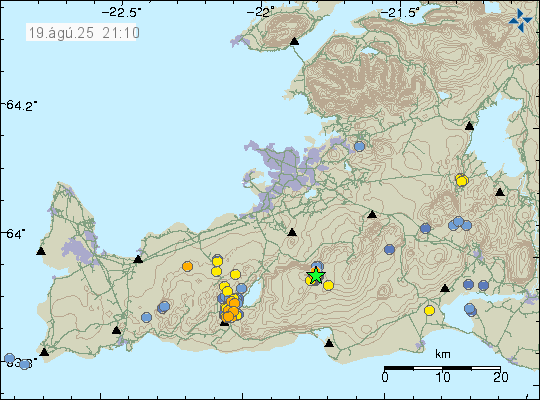
On 18-August 2025 at 18:10 UTC an earthquake with magnitude of Mw3,8 took place in Brennisteinsfjöll volcano. This earthquake was felt in Reykjavík and nearby towns.
Earthquake swarm in Brennisteinsfjöll volcano. Copyright of this image belongs to Icelandic Met Office.
This earthquake swarm has stopped. There is a lot of stress on the crust in this part of Reykjanes because of the ongoing inflation and deflation cycle in Svartsengi volcano. Larger earthquake might happen without warning.
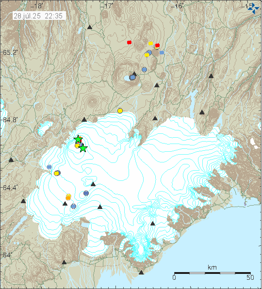
On the 27-July 2025 at 23:39 UTC an earthquake with magnitude of Mw5,2 took place in Bárðarbunga volcano. A second earthquake with magnitude of Mw3,1 took place at 23:41 UTC. That second earthquake is embedded into the first earthquake and that makes it impossible to see it in earthquake data without good analyse. The largest earthquake was felt in Akureyri, far north of Bárðarbunga volcano.
The earthquake activity in Bárðarbunga volcano. Copyright of this image belongs to Icelandic Office.
This is normal earthquake activity as Bárðarbunga volcano continues to inflate. This large earthquake happen every few month in Bárðarbunga volcano.
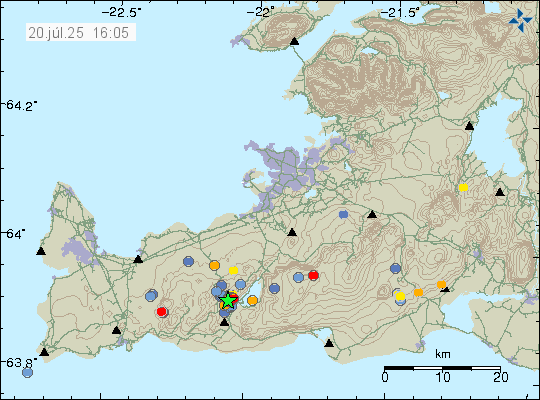
During the night of 20-July 2025 at 02:55 UTC an earthquake with magnitude of Mw3,5 took place in Krýsuvík volcano. This earthquake was felt in Reykjavík and other nearby area.
Green star in Krýsuvík volcano. Showing the main earthquake activity area. Copyright of this image belongs to Icelandic Met Office.
This is a tectonic earthquake. Possibly adjustment in the crust the eruption that is happening in Svartsengi volcano. Since the eruption results in the Svartsengi volcano to deflate. This earthquake swarm seems to be over for now.
This is a summary update with best information I have at the moment. Some information might be out of date without me knowing about it.
The eruption fissure reached 2,5 km when it was at the longest length. It has started to get smaller as the eruption has dropped in intensity over the last few hours.
This is the most northern eruption in Svartsengi volcano so far.
The lava flow is towards Fagradalsfjall volcano and into Fagradals valley and is now filling up, if it has not done so already.
Harmonic tremor looks stable at the writing of this article. This can change quickly and without warning.
Early GPS data suggest that deflation of Svartsengi volcano is around 100mm for the last 12 hours where it is most. Depending on the GPS station location in the volcano system.
Earthquake activity has stopped or almost stopped in the area.
I don’t expect this eruption to last more than few days. However eruptions in this area sometimes continue in one crater at very low volume for a several weeks. At current time its impossible to know if that happens.
Fog is currently blocking all view of the eruption. So its impossible for me to know what is happening visually.
Gas pollution has been a problem in this eruption and wind direction. This might not improve until the eruption ends.
If there is anything more to report. I’ll post update here about it. I don’t expect there is going to be any need for any future update at the writing of this article.
Updated at 00:59 UTC on 17th of July with missing information.
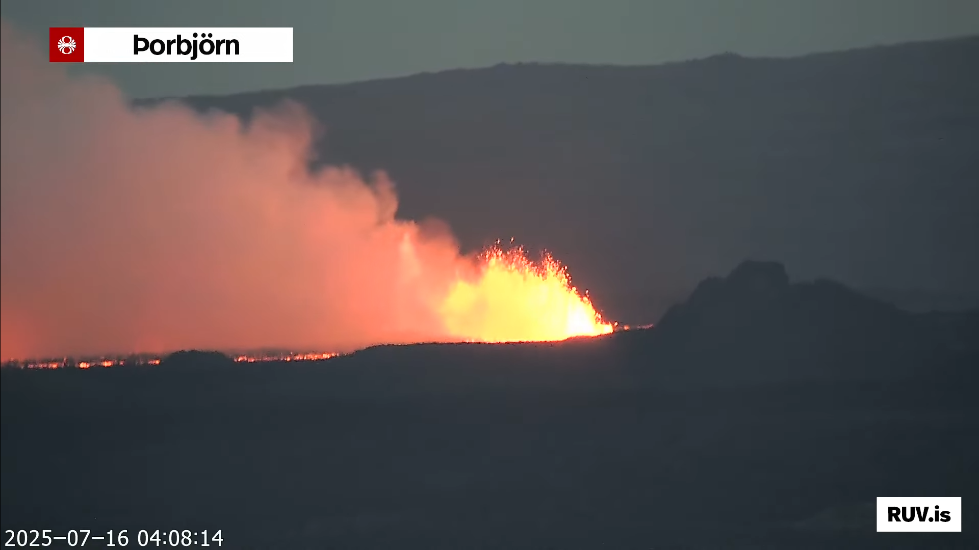
Today (16-July 2025) at 03:53:31 UTC an eruption started in Svartsengi volcano in Sundhnúkagígaröðinni crater row. This is the most northern part of the eruption area. Far from anything important. The eruption fissure doesn’t look large based on what can be seen on web cameras.
The eruption in Sundhnúkagígaröðinni in Svartsengi volcano. Screenshot from Rúv web camera on YouTube.
It is impossible to know how long this eruption is going to last. It might be few hours and up to few days. If needed. I’ll post updates about the eruption. Normally in this type of eruption that is not required.