Extinct volcanoes in Hungathing Vestra county, Iceland

Here is an picture of how an ~5 million year old extinct volcano looks out. This pictures also show an old dike intrusion that might have gone up to the surface on that time. But I think it is hard to know that for sure, as erosion has changed the landscape a lot over the past 10 million years or so. So it hard to know for sure how deep this magma dike did actually form or if it was connected to an crater on the surface.


About 5 to 8 million years old dike intrusion into sedimentary rock that pre-dates this dike intrusion. I do not know by how much older the surrounding rock actually is. But it has small fossils in them.


The volcano that did create this old dike intrusion. The rocks in the area (old lavas) suggest that this was mostly basalt that did erupt from this volcano. But this volcano was on the old Snæfellsnes-Skagi Rift Zone.


Rift Zones in Iceland. Picture is from Wikipedia. See original copy here along with copyright information. Please note that this picture is NOT completely correct in regards to the facts. But is good for basic illustration of the rift zones in Iceland. Note that this is picture is missing the Skagafjörður Rift Zone (failed rift zone).


Picture of what can be seen of the Snæfellsnes-Skagi rift Zone. (I think it is the correct name for it). The mountain behind it is also an massive old volcano that was active at the same time as this rift zone. The houses there belong to my mon and dad (also on the picture below this one). They run an sheep farm.


Picture of Snæfellsnes-Skagi rift Zone to the north. The same volcano as on picture above can also been seen on this picture. But what is not seen is the third volcano that is in this area (also extinct). But glacier activity did remove all major traces of that volcano long time ago.

I am going to post more pictures of this area during the summer. Even if it is just small part of Iceland, it has an lot of geological history to show. All of it is connected to volcanism and glacier activity over the past 8 million years (or about that) time. Too see full size of the pictures, just click on them.

Summer plan, Denmark, PayPal and other information

Summer: I am now going to start working in few days. I think that this work is from 08:00 to 17:00 every day. So updates might be an bit few while I am working. But I am going to do my best to cover what happens in earthquakes in volcanoes while I am working. But I am working so that I can pay down my debt faster then I normally would have done with just my welfare benefits that I get in Iceland. I need to pay down my debt, as it has gotten quite high since I was unable to make my living in Denmark at current time.

Denmark: I plan to moving back to Denmark in about 2 to 3 years time. But Iceland is not my place in terms of culture and people. That is just the way it is. While Iceland is my place in terms of geology that is just not enough for me. But before I move back to Denmark, I am going to have the income that supports my living in Denmark. My plan is that I am going to move to Copenhagen and live there for infinite amount of time. I might move to Portugal at later date (10 years later?), but at the moment that is just an idea that I am exploring for the moment. Nothing might happen with that idea when it comes down to it.

PayPal: I have given up on having credit card in Iceland. So I am closing it down from July. This means that I also am going to close down my PayPal account, as it is connected to my Icelandic credit card. But do not worry about this. I plan to open up an new PayPal account and connect it to my danish card. That is more easy, as it is technically not an credit card. But still can be used on the internet for paying for stuff like normal credit card. If people understand what I am meaning. This process is going to take few days until it is fully completed. When it is done, the PayPal donations buttons are going to appear again on this web site.

Other: I don’t think that there is other information. I forgot what I was going to write here, so it cannot have been important for me. But if it, then I am just going to post update here about it.

Earthquake swarm in South Langjökull volcano and Krýsuvík volcano

Today has been spotted with earthquake swarms in Iceland. This earthquake swarms have not been big so far in both terms of earthquakes and size of the earthquakes. With the biggest earthquakes in South Langjökull volcano (Presthnjúkar). The biggest earthquakes in South Langjökull volcano have been around ML2.5 in size. With the average depth of 10 to 5 km. Total number of earthquakes is something around 39 and that is an small earthquake swarm.

The area in question is known for earthquake activity. Few years ago there was an earthquake swarm in this area with several ML4.0+ earthquakes. This area did also see earthquake swarm earlier this year. So far nothing suggests that an eruption is close in this area.


Map from Icelandic Met Office showing the area with the earthquake swarm. Click on the picture to get full size. Copyright of this picture belongs to Icelandic Met Office.
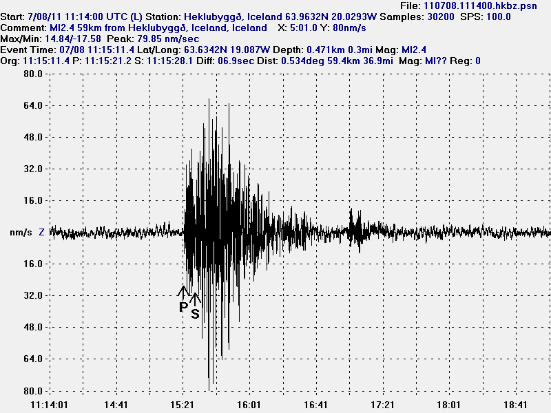
Krýsuvík volcano did also have an minor earthquake swarm today. The largest earthquake in Krýsuvík volcano was ML2.1 with the depth of 3.9 km. So far this earthquake swarm has been an minor one. With just over 32 earthquakes happening today.

Other earthquake activity in Iceland is currently not an lot. A ML3.1 earthquake took place few days ago in TFZ in an area that commonly has earthquake swarms. That area does not have any volcanoes, so earthquakes there are only connected to faults in the fault lines in that area.

Blog post updated at 23:29 UTC on 7. June 2011.
Blog post updated at 23:35 UTC on 7. June 2011.

Everything has gone quiet again in Iceland

After the eruption in Grímsfjall volcano last week everything has gone quiet again in Iceland. Earthquake activity is currently low and all earthquake activity in volcanoes remains low at current time.

Because of that I am going to take me an little break until I move to Iceland. Unless something of interest happens in Iceland. Part of this time I am going to in the sun here in Denmark and check out the beautiful ladies that populate Denmark (if you are offended by this, then I am sorry for you). 🙂

For those how want to know about my money status. June is going to be rather broke-ish. So all supported is welcomed. But I am not going to request it specially as I have done before. Thanks for the support all. 🙂

Eruption in Grímsfjall volcano is over

According to the news at mbl.is the eruption in Grímsfjall volcano did end at 07:00 UTC on the 28. May 2011. But that was when the last harmonic tremor was seen on Icelandic Met Office SIL stations.

There is an lot of volcano as in the area around Grímsfjall volcano. That means it is going to blow easy with the wind in the dry summer.

According to GPS data from Icelandic Met Office. It seems that inflation has started at Grímsfjall volcano again. But it can be assumed that it is going to take several years until next eruption. But if that is going happen we just have too see.

Morgunblaðið news about the end of the eruption.

Goslokin sett klukkan 7 á laugardag (mbl.is, Icelandic)
Grímsvatnagosinu lokið (mbl.is, Icelandic)
Gosinu lokið (Rúv.is, Icelandic)

Eruption in Grímsvötn appears to be over (hopefully correct this time around)

It appears that the eruption in Grímsvötn / Grímsfjall volcano is over or is about to end, but authorities in Iceland might not declare the eruption over until after next weekend. No ash plume has been observed for over 24 hours now from Grímsfjall volcano. Harmonic tremor pulses are still taking place in Grímsfjall volcano and it is still dangerous to get close to the eruption site. As explosion still take place in the eruption area and that makes going there dangerous. It is not only the area where the water is that is having explosions. There are also gas and explosions taking place in the crater rims and nearby area. According to news today Icelandic Met Office did stop recoding the eruption in Grímsfjall volcano around 07:00 UTC this morning (28. May 2011). But harmonic tremor pluses might still be taking place in Grímsfjall volcano. But the SIL stations around Grímsfjall volcano have now started to record background noise again, including the SIL station at Grímsfjall volcano.

Earthquake activity has continued at similar levels as before the eruption took place. I am not sure why that is. But this might indicate that Grímsfjall volcano has already started to prepare it’s next eruption. But when that might happen is a question that only time is going to answer. The main earthquake activity is currently taking place NW of Grímsfjall volcano, and SW of Grímsfjall volcano.

According to automatic GPS data it appears that Grímsfjall volcano has started to inflate again. This inflation appears to be rather rapid at current moment. But it appears to be close to 1mm/day inflation to the south and east. This means that new magma has already started to flow into Grímsfjall volcano magma chamber and magma system from greater depth. So far Grímsfjall volcano has not started to inflate upwards and it might be an while until that happens, as there might be enough space for the magma to move into inside Grímsfjall volcano.

Measurements of the volcano tephra that did fall, along with measurement of the volcano ash that did fall have recorded the depth up to 170 cm in some areas of Vatnajökull glacier even at distance of 8 km from the eruption site. This is going to create problem in the summer when it is dry and the wind blows this volcano ash around Iceland. But mostly in the areas that where closest to the main ash fall areas.

Update 1: According to news on Vísir.is the Icelandic Coast Guard did see an plume with the hight of 1,5 km yesterday. This plume was however mostly made out of steam rather then volcano ash. The news about this can be found here, along with an picture of the plume. Here is an second news of this steam plume that was seen yesterday.

Update 2: According to news on Rúv there is small harmonic tremor being recorded. But most of the time, no harmonic tremors are being detected from Grímsfjall volcano. The Rúv news can be found here (Icelandic, Picture). It also has an new picture of the eruption crater. But this picture was taken around 10:00 UTC today (28. May 2011).

Icelandic News about this. Use Google translate on this for an risky translation.

Eldgosið mælist ekki lengur á jarðskjálftamælum (Vísir.is, Icelandic)
Enginn gosmökkur í dag (From 27. May 2011, Rúv.is, Icelandic)

Blog post updated at 19:11 UTC.
Blog post updated at 20:15 UTC.

Explosions are still taking place in Grímsvötn crater

While the activity has almost stopped in Grímsfjall volcano, but there are still explosions taking place in Grímsvötn lake where the eruption took place due to magma going up, explosions take place all over the fissure at random times. That makes travelling to this area really dangerous thing to do. Ash fall is still taking place in Grímsfjall volcano when explosions take place. But the ash fall is limited to the local area in Grímsfjall volcano. Because of this, the official word is that the eruption is not yet over. Even if it just an small eruption at the moment. So far there is no data that suggests that new magma is currently flowing into Grímsfjall volcano. This is according to news in Icelandic media.

An new caldera (correct word?) has formed in the glacier close to the eruption site. But that suggests that a lot of heat is below in the glacier and is creating strong melt where this taking place. This is according to news on Rúv. But they don’t say where this glacier melt is taking place. But it can be assumed that this formation is somewhere close to the current eruption site. But when I know more about this location. I am going to update this post when I can.

Harmonic tremors pulses are still being detected from Grímsfjall volcano up to 200 km away from the volcano. Why they are still taking place while there is no eruption taking place is unknown to me. It is important to notice that currently the harmonic tremor is slowly dropping for now. But it might increase again without any warning. For now there is no way to know what this tremor means for Grímsfjall volcano.

Automatic GPS data from Icelandic Met Office tells an interesting story. According to this data (it might not be 100% accurate due to nature of GPS) Grímsfjall volcano has moved close to 320mm to the west, close to 350mm to the north, it has also lowered down about 250mm. This is major movement in Grímfjall volcano. To compare it with something, Eyjafjallajökull volcano only inflated about 60mm before it did erupt. This is many times more deflation that took place in Grímsfjall volcano then in Eyjafjallajökull volcano for example.

Earthquakes are still taking place SE and SSE of Grímsfjall volcano. There is no volcano at this location. So I am assuming that this are tectonic earthquakes taking place due to stress changes in the crust around Grímsfjall volcano. All earthquakes so far have been small but with the depth from 15 and up to 5 km.

Extra: According to new news (while I was writing this blog post). The Civil Emergency Authority in Iceland has lowered the alert level from danger level to alert level. News about that can be read here (Icelandic, mbl.is)

Icelandic News about this. Google Translate in an maze. It might work or maybe not.

Enn sprengivirkni í Grímsvötnum (Rúv.is, Icelandic)
Jarðeðlisfræðingur: Orðum ofaukið að gosinu sé lokið (Vísir.is, Icelandic)

The eruption in Grímsvötn / Grímsfjall volcano most likely not over

Here is a interesting paradox. While the eruption it self has currently stopped in Grímsfjall volcano. The tremor chart around Grímsfjall volcano is still acting like there is a eruption ongoing. I do not know why this is like this. But because of that I don’t think that geologist that monitor Grímsvötn eruption in Iceland are not ready to call off this eruption at current time. At least that is what the news did say at 12:20 UTC on Rúv.

They are also issuing warning to people not going to close to the volcano. As explosions due happen and they can throw up rocks that weight up to 1 ton. If anyone gets hit by that rock, that person does not have to worry about what happens next. The save distance for viewing the crater is estimated to be 2 km or more.

I have no idea what happens next. But I am guessing that this eruption might resume soon and without an any warning at all.

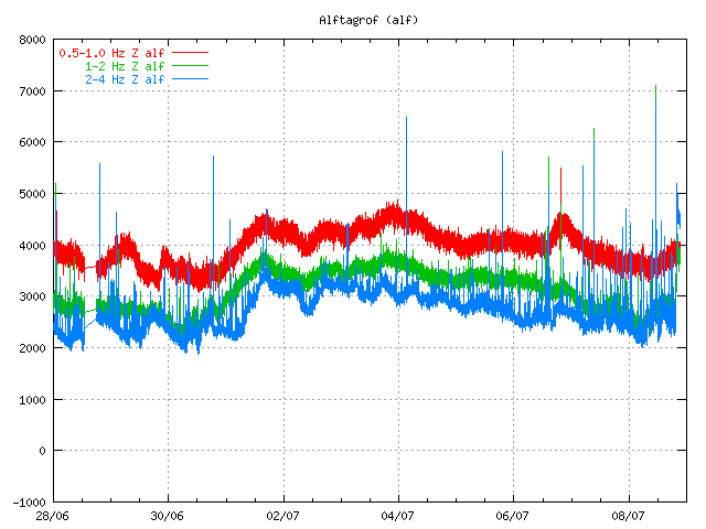
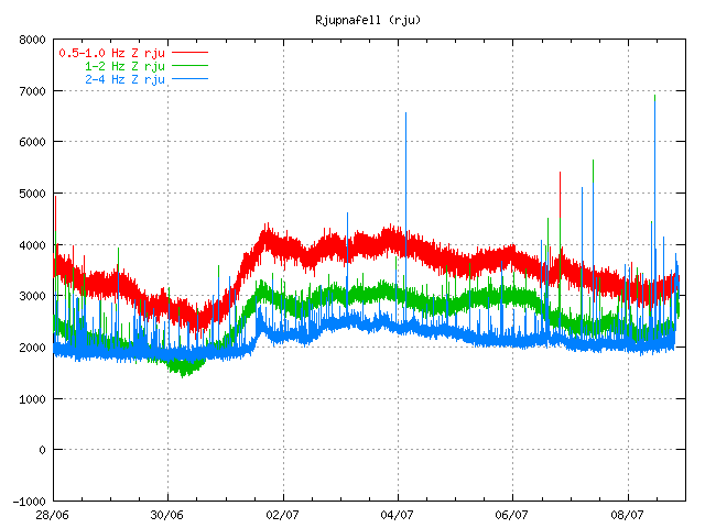
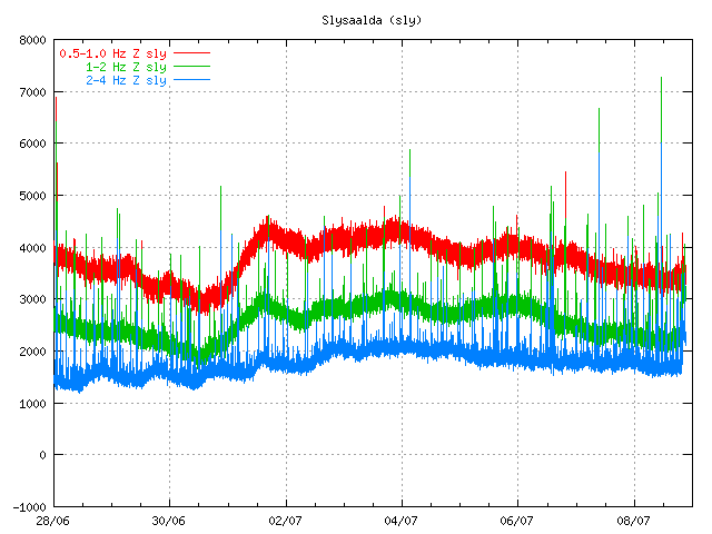
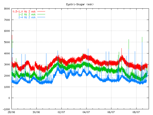
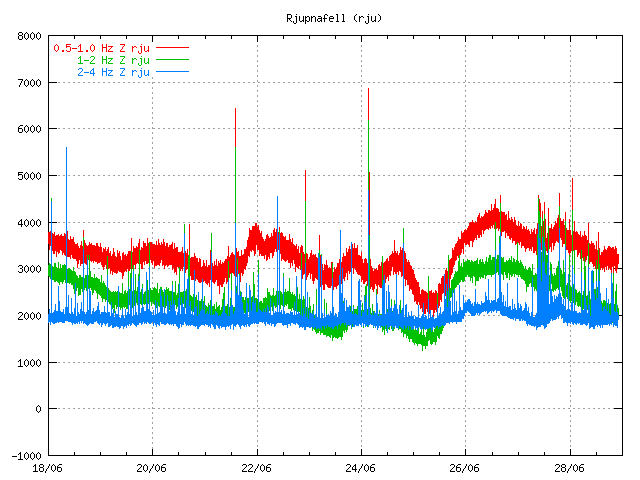
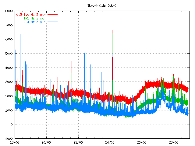
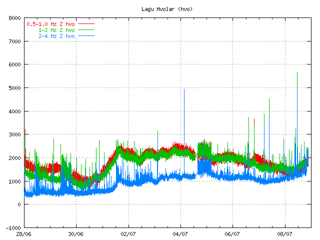
The tremor plot at 15:00 UTC. Pictures are from Icelandic Met Office.

This pattern of tremor is interesting. I am yet unsure what it means. But my guess is that this eruption is not over. Even if it has just stopped for now. I normally consider eruption over when the tremor has gone back into background noise (wind, ice, ocean etc..). That has not yet happened with Grímsfjall volcano eruption at this moment.

Update 1: Here is an tremor plot that Icelandic Met Office has released. The article where this picture is from Icelandic Met Office can be read here, it is in english.


Click on the picture for full size. I must point out that this picture is big. Copyright of this picture belongs to Icelandic Met Office.
Blog post updated at 20:46 UTC.

Grímsvöt eruption appears to be over

Given the current tremor plot on Icelandic Met Office and with reports it seems that the eruption in Grímsvötn (Grímsfjall volcano) is about to be over for now. It is impossible to know if the eruption is going to resume soon or not. But at the moment this eruption seems to be over as it looks now. If it remains like that has to be seen however.

This drop in the eruption has been confirmed by Icelandic Met Office tremor plots.

Tremor plots as of 07:00 UTC. This tremor plots are from Icelandic Met Office web site. Copyright of this pictures belongs to Icelandic Met Office.

Early news this morning in Iceland reported that steam was only coming from the main crater of Grímsvötn.

Other interesting development is that an earthquakes have started to appear SSE of Grímsfjall volcano (Grímsvötn). It is unclear why earthquake are happening at this location. But dike intrusion at this location is not impossible.

The reason for flight problems in Europe is because of the volcano ash that was ejected into atmosphere in the first days of the eruption. It is going take few days for that volcano ash to disappear from the air. Until that happens, it is going to create problems for air traffic.

Update 1: Even if the eruption appears to be over the tremor is still high. I do not know why that is. It is a question why that is or if this is just break in the eruption or not. Only time is going to tell what happens next.

Update 2: There was an news report this morning that before 02:00 UTC there was an spike in activity in Grímsvötn that did shoot the ash cloud up to 8 km. But that spike did only last for few moments before it was over. Rúv has released video here (Windows Media Player) of the eruption site.

Updated at 07:37 UTC.
Updated at 07:50 UTC.
Updated at 08:33 UTC. Blog post title updated.
Updated at 11:42 UTC.
Updated at 12:23 UTC.

Less powerful eruption in Grímsvötn / Grímsfjall volcano

It has been reported in the news that the eruption in Grímsfjall volcano (also known as Grímsvötn) is getting less powerful as the time passes. This is perfectly normal for an eruption in Grímsfjall volcano.

This can also be seen on tremor plots around Grímsfjall volcano. They clearly show the eruption getting less powerful over time. It has also been reported in the news that the material that is being erupted is now estimated to be 100 tons/second at the moment. But just yesterday it was 1000 tons/second and up to 2000 tons/second. The eruption is currently stable, even if it smaller then it was in the first few days. It is also not certain if this eruption is going to turn into lava eruption. As there seems to be enough water to continue ash phase of the eruption for the next few days.

Grímsfjall SIL station. It clearly shows the eruption getting less powerful over time.

Kálfafell SIL station. It shows the same pattern as Grímsfjall SIL station. Copyright of both pictures belongs to Icelandic Met Office.

In the news it has also been suggested that there might be less or no influx of new magma from great depth. But I do not know for sure if that is just speculation or not.

The ash plume has only got up to 3 to 5 km according to news reports. This means that has dropped a good distance in the last 24 hours. But yesterday it did reach up to 5 to 9 km. So ash is not spreading far away as it did earlier in this eruption. What is creating flight disruption in Europe and over Iceland is the volcano ash that was ejected in the first few days of the eruption. It has also been an big problem in Iceland is the volcano ash that is getting air blown on the ground. The ground is dry so the volcano ash moves easily because of that. Update 1: It has also been reported that the ash that did was ejected on the first day of Grímsvötn eruption was like all the ash ejected in the Eyjafjallajökull volcano eruption in the year 2010. They also say that this eruption was about the size of normal Katla eruption in there own estimate. News about this can be found here (Icelandic, picture)

Scientists did go today up to Vatnajökull glacier in an attempt to get close the eruption site. Flight over the Grísmfjall volcano is also taking place in an attempt to see the eruption site and take measurements of the eruption.

Update 2: There has been an minor spike in the tremor plot in the last hour or so. I do not know why that is. But this suggest that the eruption is growing in power again.

Icelandic News about it. Use Google Translate if you want some funny reporting.

Dregur úr gosvirkni (Rúv.is, Icelandic)
Dregið hefur úr eldsgosinu – umtalsvert minni gosefnaframleiðsla (Vísir.is, Icelandic)
Dregur úr gjóskuframleiðslu (mbl.is, Icelandic)

Please note that information here might get outdated really fast and with no warning at all!

Post updated at 17:57 UTC.