This information is going to get outdated quickly.
Current status on Báðarbunga volcano eruption
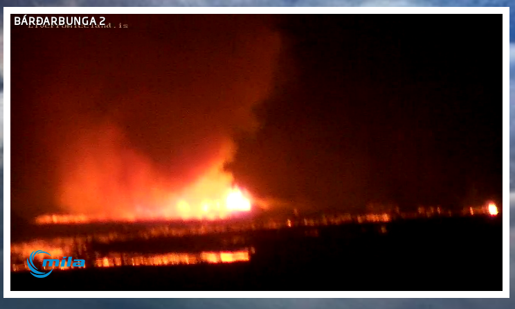
- Eruption continues in Holuhraun. Most of the craters have stopped erupting for now. The main craters continue to erupt.
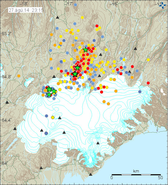
- It is my view that eruption under the glacier is imminent. That eruption would take place close to the location of today magnitude 4,5 and 3,0 took place today. When it might start is impossible to know.
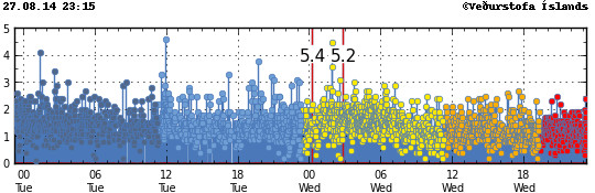
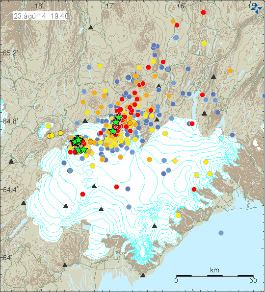
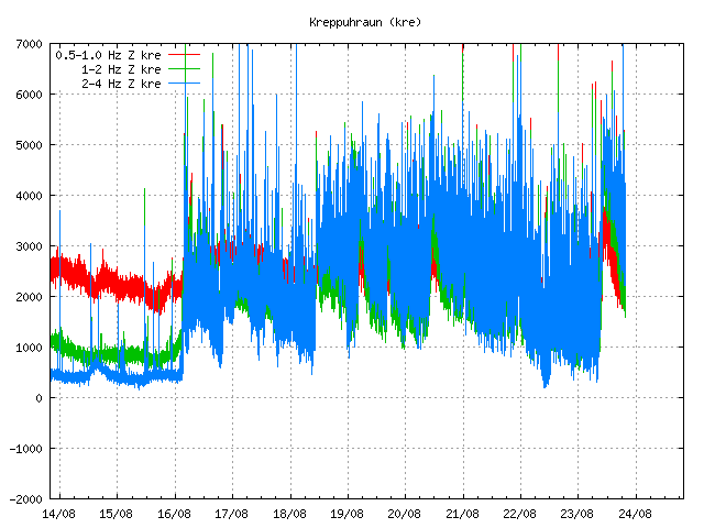
- Earthquake activity continues in Bárðarbunga volcano. With largest earthquakes today having magnitude 5,0. Most of the earthquake take place on the caldera rim, since the caldera is sinking into the crust. More on this below [1].
- The lava field is now going into Jökulsá á Fjöllum. It is currently crossing the glacier river and creating a dam in the process. Only steam has been seen in this process.
- Risk of eruption in Bárðarbunga volcano slopes is extremely high. There has not been any eruption in Báðarbunga volcano slopes since 23-August-2014.
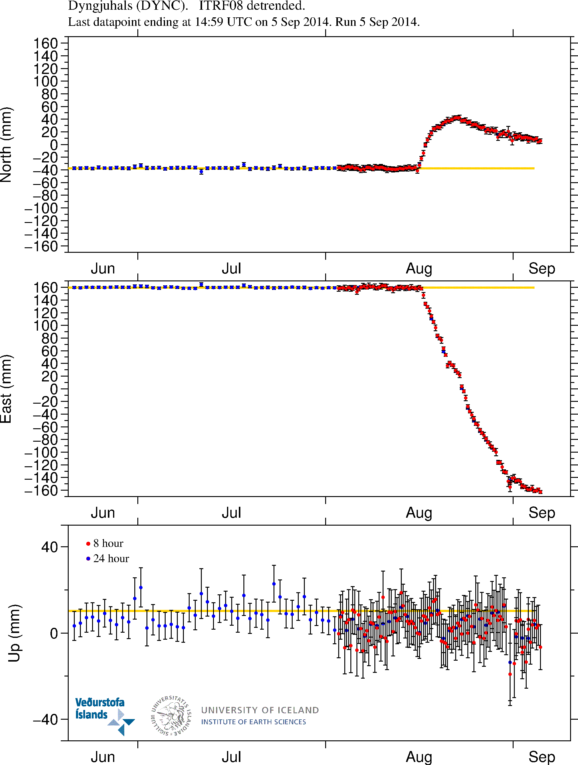
- GPS instruments have now be installed on top of Bárðarbunga volcano today. This is to measure exactly what is going on inside the volcano.
- There is less blue haze today. There is concern that it is going to have effect on people, animals and plants if the blue haze stays for long time in any given area. Acid rain is a big concern at the moment. The SO2 levels in eastern Iceland have been the highest since measurements started in Iceland back in 1970.
- There is high concentration of gas in the lava around the eruption site. It is in fact so high that it has put the geologist that are working there at great risk. Due the local weather the lava field is creating [2].
The caldera issue in Bárðarbunga volcano [1]
The caldera in Bárðarbunga volcano is dropping and it is dropping fast. According to latest news from Rúv (see link below) the caldera is dropping up to 90 cm/day. That is a huge drop for a mountain. There is also clue that central part of the caldera floor is now so soft that it no longer breaks and creates earthquakes, it is just buckling under the strain. This increases the risk of eruption in the central caldera up to almost certainty levels (for me that is 96+% chance of happening). The latest news from Rúv tell that the thickness of the glacier in the central part of the glacier is up to 850 meters thick. Since last Saturday the caldera has dropped 2 – 3 meters, meaning that current drop is now around 18,5 meters.
There is also high risk of eruptions in the slopes of Bárðarbunga volcano. None have taken place since 23-August-2014. It is not clear why that is. Some ideas say that it might be due to pressure release of the dyke eruption that is now taking place. I am now not personally convinced that is the case. The reason for lack of eruption must be some other. I don’t know what that reason is yet and I don’t think anyone knows at current time.
Local weather around the lava field [2]
The lava field has been creating a lot of it’s own weather. So much that is creating hazardous working environment for the geologist working close the lava field and the eruption site.
The local weather has also created small localized tornadoes. I spotted this one earlier today.
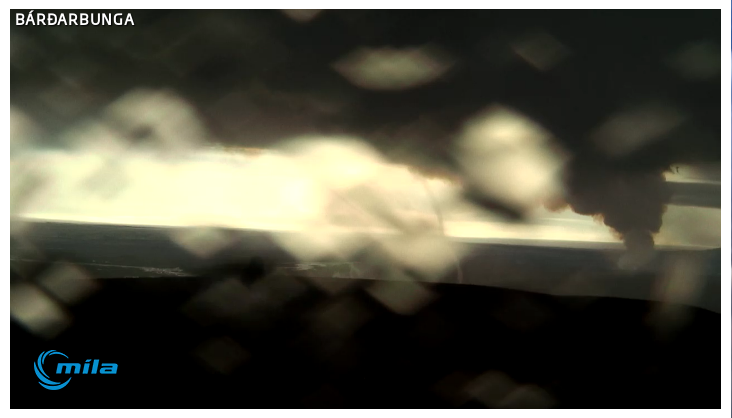
It is difficult to see the tornado on this picture. But it is the white line across the image. Image taken at 15:27 UTC on 8-September-2014. Screen-shot of Míla web-camera.
This local weather is not going anywhere while the heat is at the levels as it is now. It might even last for months after this eruption finishes.
News bits in Icelandic and English
Continuing subsidence in Bardarbunga (Rúv.is)
Askjan í Bárðarbungu sigið um 2,5 til 3 m (Rúv.is, Icelandic)
Eitt stærsta hraungosið frá því á 19. öld (Rúv.is, Icelandic)
Updates 08-September-2014
- According to latests news on Rúv this is now the largest lava eruption since 19th century in Iceland. The eruption in Holuhraun is now many times larger than largest eruption in Krafla volcano during its 10 year eruption period.
Note on comments
In order to keep things running smooth on this website. Please just post links to images. Along with some text about what they are. That also prevents the ant-spam system false flag it and me from regarding links as spam. I also have to ask people how copy data from Icelandic Met Office and University of Iceland to provide a link to the source. This is disclaimer that they added in recent weeks. I want to be on the right side of this government organizations. I also want to prevent that I have to remove comments due there demands.
Article updated on 08-September-2014 at 18:50 UTC.