Hofsfjökull volcano is not among the most activate volcanoes in Iceland. It has never erupted since Iceland got inhabited. The last eruption that took place in Hofsjökull volcano is undated, but took place sometimes in the last 12.000 years or so.
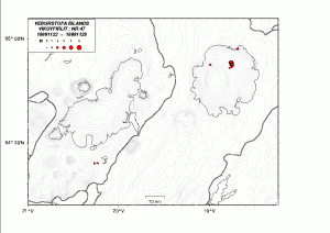
Here is a short overview of the activity since the year 1999 in Hofsjökull volcano. All pictures are from the web site of Icelandic Met Office and copyright of them belongs to them.
Last earthquake swarm took place in Week 47, in the year 1999.
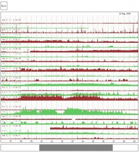
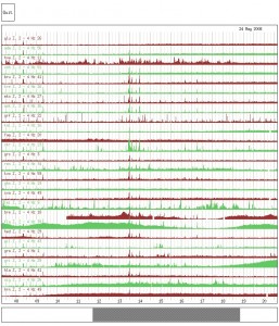
In Week 21, in the year 2008 a harmonic tremor pulse was detected from Hofsjökull volcano. This started at 13:30 UTC on the 24. May 2008.
SIL stations in Iceland showing the harmonic tremor pulse. Picture number one.
SIL stations in Iceland showing the harmonic tremor pulse. Picture number two.
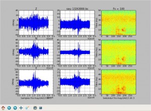
Spectrograph from the SIL station Saurbær (south Iceland, located on the SISZ).
Spectrograph from the SIL station Skrokkalda. This station is located closest to Hofsjökull volcano, along with the SIL station at Hveravöllum hydrothermal area.
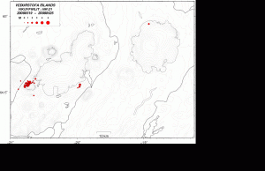
During this episode of harmonic tremor one earthquake was detected in north Hofsjökull volcano.
The one earthquake detected in Week 21 in the year 2008. On the week overview for Week 21 in the year 2008 they think that this might have been a swarm of small earthquakes that they where unable to locate. But I do not agree with that, given the data that is published on this event.
Other then this there have been few earthquakes every now and then in Hofsjökull volcano. But besides that it remains quiet and is most likely to be so for the time being.

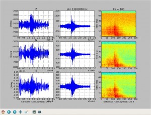
Nice graphics. I particularly like the spectral plot of the components.
What frequency in there is the most indicative of harmonic tremor? I noticed that the energy was a pretty evenly spread, hit a peak then subsided, dropping in freq.
It was from 0.5Hz and up to 30Hz far as I can tell on this pictures. Where the most red colour is, there was the most energy in the harmonic tremor.
Just an offtopic, about weather.
This week, and particularly today the weather in Europe has been hitting record warm.
25ºC or more all across the Alps (amazing for early April)
In Germany a freak sandstorm caused a huge accident in a highway close to Berlin.
Same high temperatures in UK, with 25ºC in afternoon, even high for summertime.
And temperatures around 30ºC in Portugal and Spain, with an amazing 38ºC in Murcia today! (and an unofficial 40ºC today near Murcia).
This is so crazy.
For Iceland, the east recorded today nearly 20ºC.
Nearly all Europe today in record hot.
Well, we are also having abnormally high temperatures in Rio, so, where the cool air has gone to?
Do you happen to know where this sand over Germany came from? It was like in Russia last year?
Sand?
Solar Flares…….big ones, and geomagnetic storms on the Sun are heating up the magma beneath the plates……….hence the earthquakes in odd places, volcanic eruptions, huge wind from the solar winds (energy bursts) hitting the Earth, massive aurora borealis and warmer than usual temperatures. Numerous sites are recording these. The Sun is in it’s eleven year active period and NASA has taken it’s money out of the Shuttle program and into Solar research. USGS is recording earthquakes worldwide in little swarms in places that rarely or never had any.
The answer is still no to this.
Think you should not say these things unless you have proof… The earth is unpredictable so all the things you say about earthquakes are most likely caused by the earth itself..
Sander
Well, northern Sweden has not seen any warm weather yet. +5 today, not particularly warm at all.
Yeah, I noticed the Alps were unseasonally warm when I went skiing with my parents & sister in France in February. Bearing in mind it was mid-season, there wasn’t a lot of snow when we arrived, one decent(ish) snowfall over the week we were there and it was so warm I had to spend the week skiing with my jacket undone, which I’d never had to do before. Bizarre.
Also, I can confirm that the UK is abnormally warm for April – my thermometer has been reading 25-26 degrees C all day (it’s now on 25.) I dread to think what summer’s going to be like if it keeps this up, I dislike warm weather.
Renato Rio says:
April 9, 2011 at 22:50
“Well, we are also having abnormally high temperatures in Rio, so, where the cool air has gone to?”
Los Angeles
http://wattsupwiththat.com/2011/04/08/snow-in-los-angeles-county-nws-winter-advisory/
We’re having a strong La Nina now.
And a cold Pacific Decadal Oscillation. It’s gonna get interesting. From what I understand, the Palm Sunday tornado outbreak of 1965 and the Super Outbreak 1974 were similar set-ups.
It’s colder than normal up north, and warmer than normal in the Gulf. Mix the two and you get a mess.
Its cold in Virginia, was almost a record warm two days ago..now cold, rainy, with a storm/gale warning offshore.
Thank gawd I’m not out in the VACAPES oparea. That’s got to [censored].
About the worst East Coast strorm I had to deal with was in ’93 off the coast of Florida. Everybody else was coming in but no… we had to go out and do engineering drills. Pilot asked the skipper, “You sure you want to go out in this?” Note the the sky was clear at the time. Off loaded the pilot, cleared the channel and WHAM. Wind so strong that we didn’t dare try to turn back north with so much sail area. (not sails, just the area above the waterline) We could hear all the NATO ships further out to sea trying to figure out what port to put into to get out of the mess. Two days later we were through it and went back in. A few years later I found out that my cousin was on a honeymoon cruise in that mess and managed a have a nice quiet time puking her guts out. (silently, to myself, I laughed my arse off)
I don’t think the climate is supposed to be an equal balance of warm somewhere and cold elsewhere. Naturally the sun warms the atmosphere, so this makes circulate the hot and cold masses, but if due to increased solar input, or greenhouse effect, the warming can make warm air warmer, and cold air more milder. And then, due to oceanic currents, which vary over time, this can mean colder than average in one place, and warmer than average in another.
However, I found it peculiar, several places, all across Europe, all well above average, and several in record heat, as if this huge warm mass of air decided to invade all of Europe, from Iceland to Portugal, and from UK to East Europe. All except Scandinavia.
Dunno if you picked up on the humor part of that.
Los Angeles – Snow. Los Angeles, land of the Hollywood starlets, the enviro-zealots, the beach bunnies, the beautiful people (at least in their minds eye). Los Angeles, land of perpetual sun shine and little rain.
Not so silently… I’m laughing my arse off.
LOL
It’s not so unusual to have prolonged, intense heat waves in a given area. If an atmospheric blocking pattern sets up, it can cause a heat wave the size of a small continent for weeks or even months. Look at what happened in Russia last year. It hasn’t reached that scale yet. (and it probably won’t.) These occur at some place on the planet in most years, so they’re not that unusual. They just seem extreme to the lucky recipients.
I’m in Scottsdale, AZ (next to Phoenix) where during the summers it can get up to 120+ and our winters pretty mild comparatively. This year it snowed in Febuary which is very rare. April is typically warm and sunny in the 80’s, sometimes 90’s. Last week we broke a record of 98 the first week in April. Today, a cold storm blew in and it dropped suddenly to a high of 42 and it hailed hard. I think that’s got to be a record too.
Been reading lately about the bad drought in the lower half of the U.S. farm belt (Oklahoma, Texas, etc). In Oklahoma, wheat crops are down 20% and if it doesn’t rain in the next 2 weeks, it will be down as far as 30%. The other concern is that huge underground lake that is under the U.S. farm belt is shrinking at an alarming rate causing farmers to change crops of just vacate certain areas. There are ghost towns being created at an alarming rate now.
OT. Etna in Sicily is putting a great daylight show.
A single deep earthquake in south Langjökull volcano. I think it would just be a single event and doesn’t mean anything special in the long term.
Jón, but Grímsfjal is still acting strangely. Or is it just the winds?
There is a snap storm passing over Iceland at the moment. It is going to be over later today.
Lot of snow melting in the highlands now and the melting water comes down the rivers like this one, Gullfoss in Hvítá: http://live.mila.is/gullfoss/
Off-topic: A minor update. I have now set-up Amazon EU (UK, DE, FR) so that I get money directly into my danish bank account. That means that I get paid when I get 25€ (DE) and 10€ (FR) and 25 pound (UK) amount of sales and advertising revenue.
For the U.S and Canada Amazon I am going to get a cheque as before and that has a high limit. As exchanging a foreign cheque is a expensive thing to do.
There is a really bad storm passing over Iceland at the moment. Because of that few earthquakes are being recorded.
You can say so. This was the most violent storm this year in the Reykjavik area reaching wind speeds in the gusts of up to 40m/sec. It was even worse at some villages by the seaside (thats what a friend told me).
What to think of the MW 2,2 at 100m near Katla (Godabunga)? Quality 99,0%?
We’ll see.
Henk
It is hard to say. As I did not record this earthquake due to the bad weather in Iceland.
Jon,
Over the last few weeks, for me anyway. Vatnajökull area has EQ activity has increased around 3 or 4 volcanco’s. Is this heading toward’s what happen in Russia **3 Volcano’s erupting at the same time** Looks like Vatnajökull “system” is connected and is beginning a active period. Maybe in 10 years or so some will happen or soooner?
I understand a storm was happening yesterday, but this hass been going on for weeks now.
http://hraun.vedur.is/ja/oroi/grf.gif
If you read the list of historic eruptions that I did write up few days ago. You will notice that sometimes there is a short time between volcanoes erupting in Vatnajökull glacier.
The activity beneath Vatnajökull isn’t really extraordinary except for Grimsvötn, Bardarbunga has always been very active tectonically, it had many M5+ earthquakes between the 70’s and 90’s without any volcanic activity. Except for the ’96 Gjálp eruption which might have been triggered by one of these earthquakes. So even if we would see a M4 earthquake beneath this area, it is rare, but not extraordinary/volcanic. The quakes we see now are mostly background noises, except for Grimsvötn.
Would be nice to see 2 eruptions at the same time 😛 Though the effects could be devastating in the areas surrounding the glacier which is a serious downside of it…
Sander
Thanks for the info guys, I am glad to hear the above. The info about Katla and now Vatnajökull, make me think things are lot more quieter/normal than the Irish media says. If and when Grimsvötn goes up again, I hope no live’s are lost and its a small blast. Jon do you know the record for Volcanco’s to erupt at the same time in Iceand?
Just a top of your head question.
Oh, the weather thing, 21C in Dublin yesterday, today 8-9C in Dublin. Also the Driest Month of March on record. Would Ash dry up the air and make it more tricky for it to rain. When it rain’s in Irleand the last few months, its gone when its over Dublin.
Yes that is true, the problem with media is that they began paying attention to Icelandic volcanoes after Eyafjallajökull, without looking back at previous records, so every M3+ earthquake within a 20km radius of a potentially dangerous volcano is a near-miss-worldwide-disaster for them. They just don’t know how often these things happen without any significance.
Media… I spend most of my news time poking around to so just how wrong they are.. or how much they omitted.
An OT example. A HUGE red bar scrolled across the TV last night. Knowing that the conditions are ripe for an outbreak (colder than norm up north, warmer than norm in the Gulf of Mexico, a jet stream dropping in over the cold front that tends to make the storms much stronger than normal) I took notice.
Storm warning? No. HAZMAT evacuation? No. It was an abducted child alert.
Now, I have no problem with using the system for that. It makes sense. They scrolled the counties that should be on alert… then offered NO information WHATSOEVER about what we, the concerned public, should look for. No description of a suspect, no description of a vehicle, no age, not even hair color. Just the alert. Nothing else.
My wife had to dig around on the Internet to find out what the %#$% it was we were supposed be looking for. And it wasn’t much better. It was an abducted toddler. Clothing description: Last seen wearing diapers.
I’m at the point now where I have pretty much given up on the “news.”
Well said, Pieter. Part of the problem is that many people in Europe think that a vulcano eruption in Iceland will automatically lead to disruption of Air Traffic over Europe.
Of course, this cannot be ruled out, but a complete closure of airspace is probably not going to happen.
I watched a documentation on TV in which they said that numerous airplanes fly over Hekla every day and that every eruption can wipe out a plane which is flying over Hekla at the Moment of Eruption.
That’s how mass media work… Manipulation instead of Information. 🙁
It’s not really manipulation.. it’s more a lack of knowledge about the subject combined with the hunt for the most “interesting” news item…
Well I’d rather not be in that airplane when it flies directly under an eruption Hekla, but yes, you’re right. The media tend to choose the most exciting news instead of objective reports.
But it’s not only the media, some people here (including myself sometimes hehe) tend to be a little over-excited when something happens which is anomalous in their eyes. But hey, we can do it, we’re no media. Though we do have to reconsider everytime we make an estimate (about the chance of an eruption, earthquake etc.) whether we are truly objective or if we are influenced by our excitement.
The newest subduction zone on planet Earth is forming below Africa in the Mediterranean ocean.
http://www.bbc.co.uk/news/science-environment-13015252
I don’t really understand what point they are trying to make. It was already known that Africa subducted beneath Europe right? Could anyone explain?
By the way: this ‘Utrecht-group’ is part of the University and Faculty at which I (most probably) am going to study geology in september 2012. I’ve met one of these professors who is leading in this group. (Paul Meijer)
I wish you luck then. Based on the article.. well, the reporter’s version of it, idiocy runs rampant at the BBC.
I think with regards to the new subduction zone they’re saying that the subduction has reversed – European plate will be subducting under the African plate.
So this would mean that slowly Crete will sink beneath Africa?
The BBC articles author… an “environmental reporter” has placed a lot of sexy spin on the information and made a few assumptions that are flat out wrong.
“Subduction Zones” are responsible for at least two massive calamities that involved major loss of life. The Sumatran megathrust quake, and the Japanese megathrust quake. I don’t like the use of the “mega” moniker, but I’ve seen geologists using the term to describe a specific faulting scenario. Media idjits see a term like this and run like scalded hens, cackling all the way. Like the word mega, “subduction zone” has become more familiar to the general public. It sounds smart, and reporters love to sound smart… even “environmental reporters” who have a lot of pre-conceived notions to overcome.
Where did Mr. reporter stumble? On the very nature of what a subduction zone is.
Continental crust over-riding oceanic crust. Denser oceanic crust easily slips beneath continental crust. As it does, it tends to accelerate as the weight of the subducted slab starts pulling the rest of the plate with it. This will happen only as long as you have oceanic crust to subduct. Take a look at any world map and note how much seafloor there is before you get to the continental crust. Once that part reaches the putative subduction zone, it turns into continental collision. Think Himalayas or Alps. In fact, likely due to thrust faulting, the top of the Matterhorn is African plate material.
Nah… stick a fork in this reporter. He’s done. A full blown idiot in my book. It’s too bad that what ever research he is reporting on wound up with him doing this article. I (and likely others) will now have a pre-conceived notion that it was done by a room full of monkeys with slide rulers.
Europe won’t subduction under Africa. It won’t happen. But the ocean crust that is in the Mediterranean is going to do so.
Here is the forecast for the next 50 million years.
http://www.scotese.com/future.htm
@Irpsit and Renato April, 9
OT
Rostock is located in NE Germany and is very influenced by agriculture. This is also the driest area and nearby coast. In strong winds, the sand can be swirled in from the fields. This is not unusual, but the intensity was particularly high this time.
Foehn is a warm, dry wind that that – hang downwards – often occurring on the located in wind direction downwind of major mountain ranges. And in turn, is on the German side of the Alps not uncommon.
Greetings from Germany
Danke schön, Gitta!
Must have been hell of a lot of sand, for the images I saw on TV.
It is extremely quiet in Iceland. So I am going to take a break for two days or so if nothing happens (but that normally never happens when I take a break).
There are breaks in order for there to be busy times!
Yes, Jón: take a break and come back for the party. It might not be so far away… 🙂
Lurking, quick OT question: There’s been some slightly increased activity on the CSZ off coast of Oregon. I know one can’t get too concerned with just some isolated events and I don’t have the plots of the level of activity historically, but does this raise any flags if we continue to see an uptick in moderate quakes like this?
Also, the LSF has a min swarm going on as well.
Not really. The spreading center on the backside of the Gorda microplate will always have some activity. South of there, toward the Mendocino triple junction (and pretty much in the middle of the Gorda), is always jumping. In the past, some seemingly significant quakes have gone off there with nary a word from the Cascadia.
A quick gander at the historical graph from the USGS and you can see what I mean:
http://neic.usgs.gov/neis/bulletin/neic_c0002p27_h.html
At least seven Mag 7.0+ have gone off in and around the Gorda since 1900.
And since we are on the subject, this is a graphic from Global Tectonics that pictures the formation of the San Andreas as it evolved from a subduction zone into a transform fault. The northern evolved triple junction is the one we are talking about here… the Mendocino.
http://i55.tinypic.com/w8vvgg.png
As for the LSF.. it does seem a might festive down there. The Laguna Saluda seems re0invigorated… but it all stops about 9 miles short of the Yuha Wells fault (the one that cuts transversely across Laguna Saluda – Elsinore)
The north batch seem to be associated with that small mountain range and the Centinela fault(s). (it’s a putative transverse mountain… sort of. Being stuck out in the middle of nowhere doesn’t create a lot of lift)
Thanks for the food for thought. How the hell do you stay up on all these. I finally found those historical maps that you linked in.
Thanks !
Well, actually it’s all an ongoing process. I’ll focus on an area for a while, trying to figure out what’s going on until it makes sense, read whatever research I can find, run a few spreadsheets of available data, and then move on. Forgetting to delete whatever files I’ve generated.
My hard drive is like that kitchen drawer that tends to collect stuff that was important at one time or another, and now just sits there, daring you to stick your hand in side to see if you can find a pen.
Wow only 15 earthquakes in the last 48 hours.. and only 1 in the last 12.hours. Never seen it this quite as the last 2 days.. Hope things will spice up a little the next days 😛
Sander
We had a heavy (and I mean really heavy) storm passing over Iceland since sunday. So all the small earthquakes get lost in the background noise.
One interesting question regarding this: What happens, if one of the volcanoes (lets say Hekla or Katla) decides to erupt in the middle of such a violent storm? The earthquakes connected to the immediate eruption would be lost in the noise and the experts would be blindfolded, right?
Think they will, since most of the times with a storm the mountains are also covered with clouds… which leaves no method to observe an eruption.. Quite scary!
Sander
It is really quiet. Even if the bad weather in Iceland lowers the threshold for the earthquakes that can be detected.
This last wind storm was for sure amongst the top 5 since January. But not the strongest. I remember worse storms this winter. The wind gusts were up to 150km/h in the lowlands, and more than 200km/h at times in the highlands. The ice showers were impressive too. Now its sunny, and heads up!, because the northern light activity is really high today (spaceweather.com)
I don’t know why this is. But it appears that earthquakes in Eyjafjallajökull volcano are again growing in numbers.
This pattern appears to have started late in the year 2010. So far I have not found the exact week this started. But the number of earthquakes is again growing. So far there is nothing on short term automatic GPS data.
I don’t think that this earthquakes are happening because Eyjafjallajökull volcano internal pipes are cooling down.
I will post more on this later when I have checked the data on what is going on with Eyjafjallajökull volcano.
Have been following this blog for a few months now.
I just have curious question. But would these wave patterns at askja be what is known as ‘harmonic’??
http://hraun.vedur.is/ja/oroi/allarsort.html
This is just a background noise that the SIL station records. A harmonic tremor is different then a background noise.
Thank you 🙂
After almost more than 12 h in Eyjafjallajökull
Tuesday
12.04.2011 20:43:32 63,642 -19,526 6.6 km 0.5 60.71 4.5 km SSW of Base
and one thing that keeps me aware of is the graph of tremors from the station GOD
is the steady increase of 0.5 Hz for this year, and I think that is a continuous storm, although there are peaks of them.
http://hraun.vedur.is/ja/Katla/god_trem.gif
I have a sixth sense heckla is about to blow first
The virtual eruption of the Grimsvötn between April 14th & 15th is a guaranteed certainty. 8-D
What if it happens for real? Hmm.
OT beyond belief… I’ll make it quick.
@RonF
“… How the hell do you stay up on all these…”
As an addendum… I’m also pretty good at crafting search queries. You may find this one interesting with regards to the SAF. I came up with it while trying to find additional explanatory information on a PDF slide document about crustal delamination and how it may have caused/been caused by the big bend. (the wrench configuration of the central SAF near Los Angeles) It seems that there may be a drip underneath that and a warm area under the Salton Sea… possibly an upwelling or melt associated with extention on that part of the wrench fault. While looking… their server spit out:
Forbidden
You don’t have permission to access
So… I stuck the directory string in Google and search on that. It’s… um “cool”.
http://www.google.com/search?q=http%3A%2F%2Fseismo.berkeley.edu%2F~rallen%2Fteaching%2FS04_SanAndreas%2FResources%2F&ie=utf-8&oe=utf-8&aq=t&rls=org.mozilla:en-GB:official&client=firefox-a
I seem to remember reading an article on the theory of how the flooding from the Colorado river used to periodically flood the salton sea area and that this made the southern tip of the SAF more active historically due the alternating weighting, so perhaps if you factor in water and increased activity….just stabbing in the dark 🙂
That LSF is sure busy lately. It portends activity in So Calif but where and when, can someone tell me 🙂
I just get a wild hair saying its soon
Well, one graphic that I ran across… the one that prompted me do dig deeper, indicated that the southern end of the wrench fault, the part that has extension and thinning, is underlain by material that is “more warm/hot” than that part under the compressive end. (where the transverse ranges are thrust upward) That area has colder material that may equate to a drip back into the athenosphere.
As for the Colorado… much of what I have read indicate that it used to enter the Pacific ocean through the Monterey (subsea) Canyon at the time that it was in alignment with it. Sediment dumping is what caused the Salton Sea to eventually be separated from the Gulf of California, and that is a lot of weight. You may be correct in your observation.
Katla: MW 1,9 at 13,9 km depth, only poor quality: 38.35
Still: exciting!
Henk
Careful people of Lilliput, don’t get too excited, Gulliver is waking up and he’s not happy.
http://www.rp-online.de/panorama/ausland/Neuer-Vulkanausbruch-ist-ueberfaellig_aid_986688.html
Very badly researched. First of all, they make Katla and Hekla male instead of female, secondly the say that experts suggest that a Grimsvötn eruption could wake up the big volcano \Laki\.
Indeed a little strange article, but the general idea is true.. Grimsvotn and Hekla are the volcanos which are most likely to go first..
The Laki thing rises a question, is it possible that the Laki fissure (or any other fissure) will ever erupt again? Since from what I know/heard/read fissures mostly erupt once in contrast to the central volcanos they belong too
Sander
Taking a spin in Google Earth at the Laki and Eldgjá area show a lot more than just those two lineaments.
Maybe the cone line for a specific eruptive event stays inactive, but the forces at work certainly don’t.
There will be another event.. probably thousands more. But that’s in geologic timescales and we may not be around to see it.
Is the weather causing these raises in the links below or maybe Winter Snow or something else.
http://notendur.hi.is/runa/eyja_gps.html
http://strokkur.raunvis.hi.is/~sigrun/GFUM.html
Looks like its Latin writing to me.
BBC link below about Yellow Stone “Super Volcanco”
http://www.bbc.co.uk/news/science-environment-13061779
Erik Klemetti has written a post today “Eyjafjallajökull one year on: What have we learned (and not learned)?”
http://bigthink.com/ideas/37870
I’ve learned to not trust the post office. I’m getting mail from a prisoner addressed to a different street and my pay checks haven’t shown up in over a month.
Sorry… I’m just ticked off.
I think that Eyjafjallajökull’s fame had a lot to do with the short sightedness of the various EU authorities and the knee jerk reactions, in part fueled by a highly excitable and rabid press.
Other than that, most of the EU’s problems were due to the North Atlantic Oscillation and the variability of the Icelandic Low in those conditions. Eyjafjallajökull happened to have gone off when the prevailing conditions directed its ash plume towards Europe. The NINE previous Icelandic volcanic eruption didn’t freak everybody out as badly.
My guess is that a well established (stable) Icelandic Low directing the ash plume towards the open ocean had a lot to do with it.
A repost of my graphic (I also posted it on the Eruptions blog)
First, how to read it…
A positive NAO means a stable and well established Icelandic Low (a semi-permanent atmospheric feature). A negative NAO means that the Icelandic Low and the Azores/Bermuda High are in flux and moving around quite a bit. The Az/Bm high drives the tropical systems. Together, they steer most of the airmasses in the North Atlantic.
As you can see, the other nine eruptions did not occur during strongly negative NAO conditions. That means a stable Low/High relationship.
http://i51.tinypic.com/72d6o6.png
Moderate swarn over near the western border of Nevada south of Hawthorne. It started last week I believe. There was another large swarm in Jan 2011. Maybe this is getting ready for a larger event. The Pdf link below shows the major EQ history and other related info. I would stock up on provisions if I lived in Hawthorne, but then again, I think those miner types can survive just fine.
http://www.nbmg.unr.edu/dox/e16.pdf
Historical Map: http://neic.usgs.gov/neis/recent/nn00332872_h.html
Dunno, our minors are always having trouble getting through the TSA check-points with out getting molested.
New blog post is up and it is about Eyjafjallajökull volcano eruption in the year 2010.