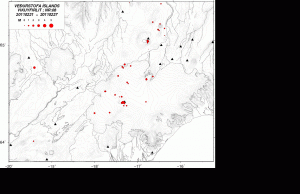
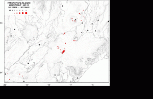
Here is a short overview of the activity in Grímsfjall volcano in Week 08 and Week 13 for a comparison. A quick review of the earthquake data on the Icelandic Met Office web page suggests that the current path to a eruption started in Week 07.
It is clear on the pattern that has been evolving over the past four to five weeks where the eruption is most likely going to happen. That location is almost directly below the SIL station that Icelandic Met Office.

Week 08. Picture is from the Icelandic Met Office. Copyright of this picture belongs to Icelandic Met Office. Click on the picture to get full size.

Week 13. Picture is from the Icelandic Met Office. Copyright of this picture belongs to Icelandic Met Office. Click on the picture to get full size.
The evolving cluster of earthquakes can clearly be seen in this week overviews, and other in between them (Week 07 to week 13). It is clear that the magma has found a collection spot inside Grímsfjall volcano. But the question remains where it is going to break it self when a eruption starts. It is rather that question rather then when it happens, given the earthquake pattern that I am seeing coming from Grímsfjall volcano at current time.

Interesting, but would be the location of this cluster be the same as the place where the magma will pop through the crust? I highly doubt so, magma always chooses the easiest way, and I believe the SIL-station is situated right on top of the mountain peak. It would be weird if the magma would follow the rockbed all the way to the top of the mountain, instead of searching for a lower escape crevice.
Offtopic:
I’ve got a small question for the Icelandic people (or people who often go to Iceland). I’m thinking of travelling to Iceland this summer/fall to stroll around a bit and I might do a small project for school, related to seismography/volcanism. Though my main purpose is to travel around a bit and see more places than I’ve seen last time. (I only went to Landmannalaugar/Thorsmork last time)
The only problem is; money and travelling in Iceland. I only have about 700-800 euro’s to spend for about 4-6 days in Iceland. The flight would cost about 350-400 euro’s, so I got about 400 euro’s left to spend on travel and a place to stay. Now I thought of the cheapest/easiest way to do this; camping. But my question is, is camping on your own in Iceland good? And how easy is it to travel around without a drivers license, so how is public transport? (Public buses are rather expensive I believe?) And how do-able is hitchhiking? Any ideas? Please share! 😀 Thanks!
@Pieter:
I cannot help you in such travel details, but only envy you and hope you will have the greatest adventure in this wonderful country.
Please, only be sure you take a good camera and bring back some nice images.
I also hope that you get lucky enough to see lots of volcanic activity . 🙂
As for the SIL station location, is that anywhere near a vent? Because if there is a fault leading to an old vent it could easily be affected, as Jón has implied, even if it is at higher grounds.
Magma is collecting there. But if it breaks up there is a good question. This might open up as fissure and that might change how the eruption behaves. But we have to wait and see what happens.
You can find the public transport information here, http://www.bsi.is/
Check out carpooling in Iceland http://www.samferda.is/
Hitching a ride is fairly easy for a single person (depending on place and time) but at your own risk
For somewhere to stay I would recommend http://www.couchsurfing.org/ it is free and you get to know locals.
Dear Pieter,
We have travelled 4 times to Iceland and all 4 times we were camping. Believe it or not, but we have stayed on a camping which was completely free of charge. The only “demand” was to keep the place tidy, but this camping had a wasmachine, electric stove, hot water, a table and chairs and toilets. The wooden cabin was also heated. The grass outside (for the tent) was good and comfortable.
This camping is situated in the north near Blönduós in a cude little town called Skagaströnd.
But the other campings are not too expensive either. The temperature in the summer is at night not too bad, we only lost two tents due to heavy winds; last year at Heimeay and Skaftafell (wind >40 m/s).
I can show you pictures and tell you more if you like.
I live in Zwaag (Hoorn) and my emailaddress is: henk.maukie@hotmail.com
Kind regards,
Henk
O.k. emailddress stays hidden; sorry for any inconvenience I have caused with this action!
You can phone me if you like: 0229 – 260011.
Henk
You can easily hitchhike if you come between mid June and mid August. You can bring your tent, mattress and sleeping bag, and camp anywhere you go. Wild camping is allowed and easy, everywhere except in the national reserves. But camping parks are also widespread and then you have more facilities. I did both last summer and hitched all across Iceland. Along the ring road is easy, in other places it might be too, but the wait can be longer (like 1-2 hours). But even with little cars passing, you can get lifts easily. Icelandic people are very helpful. Hitchhiking is only difficult in the West Fjords, the East, and of course, the highlands. Only remember that it is very important to have clothes for the extremely rainy weather and some cold. Many tourists get in big trouble because they go unprepared to the mountains. The nice thing is you don’t have to mind about getting darker (there is no night in the Icelandic summer)
Yes, also remember that when you camp, do it in sheltered places. Wind can get strong in Iceland and blow your tent away. Check the forecast often. And if the weather is bad look for a hut. Also bring lots of food from Reykjavik, they don’t sell food in many places in Iceland.
What kind of erruption are we most likely to see if it errupt? If it breaks the ice.
A Surtsey volcano type eruption. Since this is under a glacier, there is going to be volcano ash fall from it. It should be something in the line of the eruption that took place there in the year 2004. But it is hard to know for sure.
Cant’ wait to see what happens…
(BTW check your Paypal account. I only wished I could have more cash available)
Thanks for the support Renato Rio. This is more then enough. As many small things add up you know. 🙂
Mankind owes to artists and scientists its true wealth.
This is so little compared to what you deserve.
Keep doing your great work.
In time you will get the awards for all the hardships you have been through.
Just keep your eyes wide open. 🙂
Like I promised I donated € 10,00 sunday evening.
Like Renato I am sorry I can’t give you more.
Kind regards,
Henk
Thanks for the support Henk! Even if it is just €10 it adds up.
A paper showing the extent of the Grímsvötn subglacial lake. Also in here is an image of the uplift from 1998 to 2004 and figure 4 gives you a good spatial reference to the Gjálp fissure (1996 event).
etienne.berthier.free.fr/download/Berthier_et_al_EPSL_2006.pdf
Thanks everyone for answering my questions, both the carpool (+bus) and the couchsurf sites look very interesting! And Henk, thank you for the information, I will contact you for some advice as soon as I have worked out my plans.
Last question: How easy and expensive is it to run a Helicorder/other form of seismograph for about 3-4 days? Thanks!
A new blog post is up. 🙂
I am having problems to access the new blog post!
What is up, Jón?
I get a message:
Not Found
Apologies, but the page you requested could not be found. Perhaps searching will help.
Something odd is going on here. The post was set to private and it has been in part removed.
I am looking into the matter. But I put what was left of it on display again. I do not know what is going on.
No, I don’t see the new link either, and incrementing the page numbers is not working either. I was not aware on Erik’s site that you were looking for this new blog entry. Sorry for the mistake.
The newest post was edited by someone else then me. Part of it has been destroyed and lost. I am looking into the matter now.
The blog post has been restored to it’s original version.
Thanks, Jon.
It works for me now.