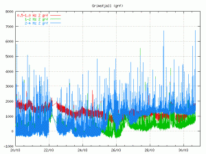
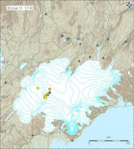
Few days ago changes started to happen in Grímsfjall volcano. It is hard to describe this changes. But they appears to be changes in harmonic tremor levels in Grímsfjall volcano. But they appears to be above background levels and the reason why that is a bit unclear at the moment, but I do not think that this is ice movement as I did think it was first. As this has been lasting for too long. Following this has been a slow increase in earthquakes in and around Grímsfjall volcano. This earthquakes don’t appear on the automatic SIL system, even if they are up to ML2.0 in size. This suggest that there origin is from magma movements, not tectonics one (tectonics earthquakes also happen there).
So far nothing suggest that a eruption is immanent. But that can change without any warning. As Grímsfjall volcano is known to start a eruption with no warning at all.

Harmonic tremor levels in Grímsfjall volcano on 30th March 2011. Picture is from around 17:30 UTC. Copyright of this picture belongs to Icelandic Met Office. The picture is from there web site.

Earthquakes in Grímsfjall volcano on 30th March 2011. Picture is from 17:30 UTC. Copyright of this picture belongs to Icelandic Met Office. The picture is from there web site.
All that can be done for now is to wait and see what happens. But my opinion is that something is up in Grímsfjall volcano. But what that is remains unclear at the moment.

How do you know that (more) earthquakes are happening when they are not recorded by the SIL system?
They are recorded by the SIL system. But to not appear on the automatic lists on IMO web page. The reviewed list shows this cleary. Reviewed earthquakes also appear on Icelamdic Met Office web page (new one) with quality of 99,99.
Yes, I’ve noticed that they’ve been adding quake near Grimsvötn way after they happened. Is that what you mean?
Oh and why are volcanic-earthquakes so hard to detect for them? Is it because of their low frequencies?
They don’t have clear P and S waves. That makes them hard to locate and estimate the size.
Is this the same for the quakes which hapened a few days ago under Eyjafjallajökull which showed up on the map but not in the table?
For a earthquake to appear on the automatic map it has to get the quality 30,00. If it is lower then that, it does not appear on the automatic map.
We have tremor: a good sign
We have a small swarm: a good sign
We had inflation followed by deflation: another good sign, the magma pushed up, now the pressure is reduced by some cause, and this could allow magma to finally surface
In either 1998 or 2004, the eruption followed about a week after a minor swarm.
How about the activity at the rivers? Any increase at flow or chemicals on it?
For the record, this for of (harmonic?) tremor has happened before:
http://hraun.vedur.is/ja/vatnajokulsvoktun/grf_trem.html
form*
This is a higher level of tremor. But it is not a volcanic one. I am using this one to check on the tremor levels, the one you did point to is not that good in estimating the long term tremor in my opinion. But it going to be good to look at it if something interesting happens.
http://hraun.vedur.is/ja/vatnajokulsvoktun/oroi_grf.html
Two deep EQs SW of Hekla in 2 days.
As a small help for those who are wondering what Primary and Secondary seismic waves is (P/S waves).
http://en.wikipedia.org/wiki/Seismic_wave
There is alot of relevant information there.