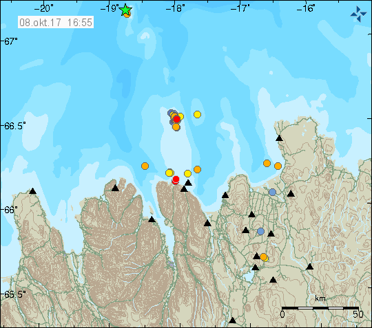
Today (Sunday 08-October-2017) a minor earthquake swarm took place in Kolbeinsey Island. Only three earthquakes where detected, but that does not rule out that more earthquakes happened but where not detected due to distance from land and the SIL network.

The earthquake activity is marked by the green star to the north on this image. Copyright of this image belongs to Icelandic Met Office.
Largest earthquake detected had the magnitude of 3,1 and the second largest earthquake detected had a magnitude of 2,1. Since 10:33 UTC this morning, that lack of activity does not rule out more activity in next few days.
New SIL station
I did see in the news today that Icelandic Met Office has added a new SIL station at Bjarnarey Island. This increases the earthquake resolution for Vestmannaeyjar area along with improving earthquake detection in Katla volcano and making it possible to detect small earthquakes deeper south of Iceland.
Icelandic news about the new SIL station, Jarðskjálftamælir í Bjarnarey að frumkvæði Vinnslustöðvarinnar (eyjafrettir.is).
Icelandic Met Office has also moved the SIL station in Vestmanneyjar Island around. The old location was not usable any more due to cultural noise from the population in Vestmannaeyjar Island.

Great another Sil .. but where have all the GPS stations with live data disappeared to? Do GPS stations even exist anymore? Have all ground movement changes been made Top Secret and hidden from the public? EHY? WHY? WHY?
You can find the gps data here. Icelandic Met Office is updating their website and that takes some time.
http://brunnur.vedur.is/gps/time.html
Thanks, Jon.
Good GPS data there. Although, it would be better if they had a map of Katla with clickable GPS stations, so the gps data for the clicked-upon gps station would be seen in a pop-up window (or shown on a separate web page in response to the click). (They might have had that in prior years?)
I think there will be very significant and noticeable uplift at some of Katla gps stations before the next major eruption occurs there. In particular, I’d expect AUST to be a clear and early indicator before another eruption occurs.
What are your thoughts on that? Do you think other GPS stations would be as important or more important than AUST?
3,1 13. okt. 05:18:21 Yfirfarinn 8,2 km ASA af Bárðarbungu
2,9 13. okt. 00:22:11 Yfirfarinn 7,0 km ANA af Bárðarbungu
http://www.jonfr.com/webicorders/tremoren.htm
There is going to be article tomorrow on Bárðarbunga volcano activity. This is normal activity so it is not in high priority to write about.
http://hraun.vedur.is/ja/oroi/allarsort.html
What the hell is going on in Iceland ???
Really bad weather. There is a new storm coming tomorrow in Iceland. It is going to last 2 or 3 days at the most.
That things go to a better conditions, is my desire.
Cheers