
Yesterday (25.02.2017) an earthquake happened in Bárðarbunga volcano. For some unknown reason, Icelandic Met Office has not located this earthquake or given it exact magnitude. I estimate based on what I see on my geophones that the magnitude is in the range of 3,2 – 3,8. Location is somewhere in Bárðarbunga volcano, since I just two geophones running in Iceland at the moment, I cannot give exact location. In order to get exact location I need more than three geophones.

The earthquake as it appeared on my geophone in Böðvarshólar. This image is under Creative Commons Licence, please see CC Licence for more details.
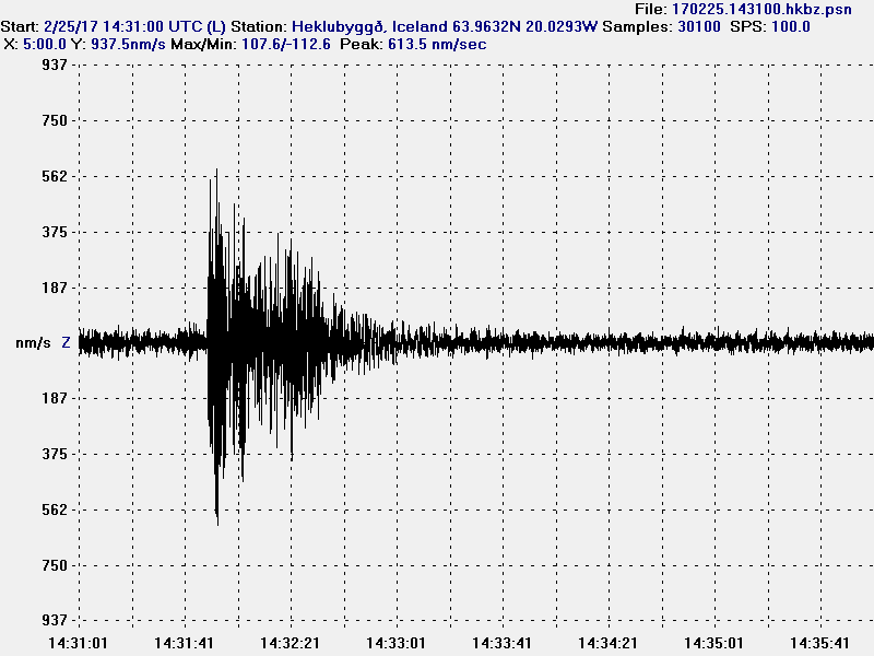
The earthquake as it appeared on my geophone in Heklubyggð. This image is under Creative Commons Licence, please see CC Licence for more details.
I’ll update this article once I get the exact location and magnitude from Icelandic Met Office website.
Update
The weekly earthquake list has this earthquake at magnitude 2,58Mw and ML3,03.
227 20170225 143125.453 64.64607 -17.35535 0.065 2.58 3.03
Article updated at 20:56 UTC on 27.02.2017.
Jon, all 3 main SIL stations around Bardarbunga are offline at the moment (von, dyn and kis), so earthquake triangulation and determination is a bit hard and probably takes extra effort.
Wow, something going on at Bardarbunga!!??
Whats going on in Iceland now? Seems like quite some hefty swarm is in progress
Am I right and is this the only available webcam at the moment of Bardarbunga? http://vedur2.mogt.is/grimsfjall/webcam/
Look at this
http://brunnur.vedur.is/myndir/webcam/2017/03/01/webcam_jokulsaS.html
Great!! Thanks!
Well good morning Bardy…Bang wallop burp !
3 quakes well over 3 magnitude !
[color=red][b]Wednesday
01.03.2017 09:45:02 64.671 -17.423 0.1 km 3.5 99.0 6.0 km NE of Bárðarbunga
Wednesday
01.03.2017 09:38:11 64.664 -17.377 0.1 km 3.0 99.0 7.6 km ENE of Bárðarbunga
Wednesday
01.03.2017 09:21:28 64.664 -17.389 1.5 km 3.5 99.0 7.1 km ENE of Bárðarbunga
Wednesday
01.03.2017 09:13:14 64.671 -17.422 0.1 km 3.4 99.0 6.1 km NE of Bárðarbunga[/b][/color]
It was updated to M4.1, M3.8, 2X M3.5 and M3.0.
They keep updating…