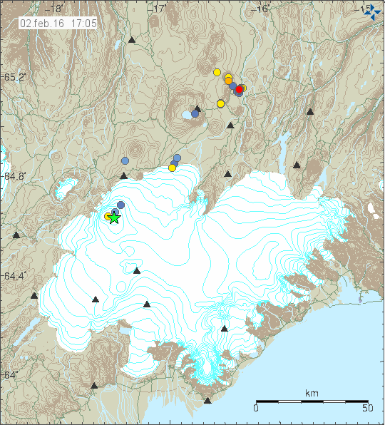
The activity in Bárðarbunga volcano continues to slowly increase, at the moment there seems to be a small lowdown in the activity but that might change without warning. There has been some change in the activity inside the caldera and that is important. There appears that two spots are forming inside the south part of the caldera, suggesting that magma has found a weak spot in the crust plug. The space between them is not big, at most 800 meters to 2 km. The weak spots might not erupt, the magma that is pushing up at this location might fail breaking trough the crust if the pressure is high enough to break trough the crust.

The green star marks the second weak spot in the caldera of Bárðarbunga volcano. Copyright of this image belongs to Iceland Met Office.
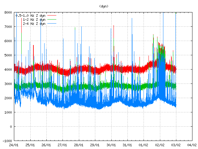
Yesterday (02-Februar-2016) signal appeared on the SIL stations around Bárðarbunga volcano. This signal was seen good distance from Bárðarbunga volcano, this does not appear to any type of failure in the SIL network, I’ve been looking for such and not found any. What this signal means is unclear and why it happens is unknown.

The strange signal starts around midnight at 02-February-2016 and continues until at least 05:00 UTC. It is not known why it happens. Copyright of this image belongs to Iceland Met Office.
The largest earthquake in past 48 hours had a magnitude 3,0 and was in the newly formed weak spot in the north-east part of the Bárðarbunga volcano caldera. Both weak spots in the Bárðarbunga volcano caldera have been having earthquakes this week and past week, in most of the caldera there has been some earthquake activity taking place. In late August-2014 the north-east caldera rim did leak some magma, creating a row of cauldrons above it. Both above the dyke and on the cauldron rim. I did try to find pictures of the cauldron in question, but I didn’t have any luck doing so.
Magma pressure inside Bárðarbunga volcano seems to be increasing faster then I expected. Something might have changed inside the volcano, or deep underneath it allowing for magma going inside the volcano at higher rate then before. It is not possible to know when next eruption in Bárðarbunga volcano happens, the time frame (based on historical data) is from 1 year and up to 10 years when a eruption cycle is going on.

I have two links to pictures of the cauldron:
http://jardvis.hi.is/maelingar_siginu_i_bardarbungu_med_flugvel_isavia_tf_fms_24_oktober_2014
http://glacierhub.org/wp-content/uploads/2014/09/cauldron-Dyngjujokull-source-Almannavarnir.jpg
…and at this page the third one (Landsat) is interesting:
http://avd.is/is/?p=1076
Jon. I seem to remember that there was a fly over video showing the cauldrons you are looking for. Have searched my saved videos but not found it.
This one shows the locations of the cauldrons pretty well:
http://i.imgur.com/Fdxrxze.jpg
Whatever it is that is being picked up by the monitoring systems, it comes in immense numbers. On a ‘normal’ day, there is not even a sixth of today’s current registered data.
http://hraun.vedur.is/ja/alert/2016/feb/03/index.html
Wednesday
03.02.2016 19:50:08 63.910 -21.979 7.0 km 3.8 99.0 4.9 km ENE of Krýsuvík http://en.vedur.is/earthquakes-and-volcanism/earthquakes/reykjanespeninsula/
Magnitude 3,9 earthquake in Krýsuvík. Article soon coming up (I need to get me something to eat before I start writing).
I just noticed that this page is back online! 🙂
It was gone short after the Holuhraun-eruption ended.
http://platformsthatwork.com/bardies/quakesonaplane.php
Play around with the menu bar. There are many nice things to discover.
Like this one: http://platformsthatwork.com/bardies/3dScatter.php
Mw 3.5 / depth 100 metres / ESE of Barđarbunga
Now when they say .1 k is being measured from sea level or from the surface of the crater??
Normal measurement, 0,1 km is 100 meters (give or take).
sorry is it being
Yes I get the distance I’m just confused as to .1 k or 100 meters from what point, the crater floor , sea level , or the rim of the crater? I have never found where the measurement is from. I guess what I’m asking is where 0 is taken to get that distance. For example when they make a call of say 1k down where is it 1 K from? So when they say its 100 meters in depth is that from the crater floor or sea level? Because when your talking about 100 meters for depth in the Tjörnes fracture zone I figure they are talking sea level but way up in Vatnajökull the surface of the ice field is well above sea level, but if its still referring to sea level then its still a few hundred meters from the top of the crater rim.
From the point where the earthquake took place. In this case the caldera rim.
I suspect that an earthquake swarm might take place close to Trölladyngja in few days time. Based on the harmonic tremor readings at Vonarskarð and Dyngjujökull. How that develops is impossible to know at the moment. That won’t be clear until the activity starts.
Nice job on the Trölladyngja prediction Jon looks like things may already be starting by the look of the last few events.
It won’t start until the strange noise on Dyngjufjöll SIL station stops. What this is I don’t know.
http://hraun.vedur.is/ja/oroi/dyn.gif
Carl(the expert?)at the other blog,says that is weather related?As for earthquake 0.1 km under the rim….cryptodome?
It’s just Dyngjujökull this time. A good week ago this strange signal was picked up on Dyngjujökull, Mokollar, Kreppuhraun, Askja, Vonaskard and even Svartarkot.
Strongest spikes appear on SIL stations around Vatnajökull. My best idea is that this is magma inflow, like the one was seen when the dyke formed. Expect it is flowing trough established channels underground. I might be wrong.
There is no cryptodome under Bardarbunga.
ok I’m a bit confused does there not have to be a cryptodome under every volcano? At least I always thought that there has to be a place for the magma to pool before it exits.
It really just means a dome of magma,usually viscous,that has not breached the surface.In a volcano with an open vent ,the magma dome will just form in the open vent.If there is no open vent then magma can accumulate close to the surface but not breach it and that is a cryptodome as I understand it.OK there maybe no such dome in the Caldera of Bardarbunga,but who knows?
Mystery solved for now. This is a connection problem with DYN SIL station. It can be seen on the drumplot.
http://hraun.vedur.is/ja/drumplot/drumplot/dyn.png
This means it’s not connected to magma movement. There however is something going on Vonarskarð SIL station and that station is not having any connection problems.
http://hraun.vedur.is/ja/oroi/von.gif
Other SIL stations are beginning to show it again too now. It looks like Iceland is on steroids.
Jón, is there a new report coming up soon? Only Miss BB has acquired two green stars since the last one. Apologies if you are too busy with other things, of course.