
This is a short update on the TFZ earthquake swarm. There is no point in making a long update about what is taking place in TFZ at the moment. Since information gets outdated quickly during this earthquake swarm.
About 775 earthquakes have been recorded by Icelandic Meteorological Office since this earthquake swarm started on 2. April 2013 (about 48 hour period). This number is going to be outdated soon or already is outdated by the time this blog post gets published. Since there are about 40 – 60 earthquakes every 1 hour currently. The earthquake swarm however drops regularly in terms of activity. Over 80 magnitude 3.0 earthquakes have been recorded so far. This number is going to increase if this earthquake swarm continues as it has been doing for the past 48 hour period.
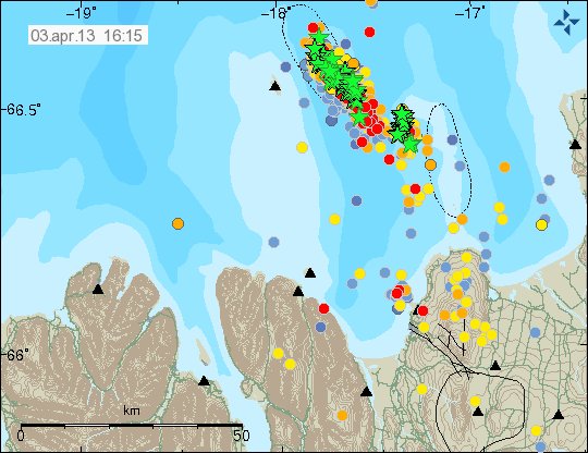
The earthquake activity in TFZ. The green stars show the earthquakes with larger magnitudes then 3.0. There is a second fault that has gone active since the earthquake activity started yesterday (02.04.2013). Copyright of this image belongs to Icelandic Meteorological Office.
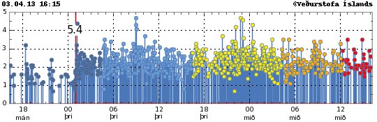
As can be seen here. The earthquake swarm has been really powerful at times. Copyright of this image belongs to Icelandic Meteorological Office.
This earthquake swarm is the largest one in the area for long time now. At the moment there are no sign about that this earthquake swarm is about to end any time soon.
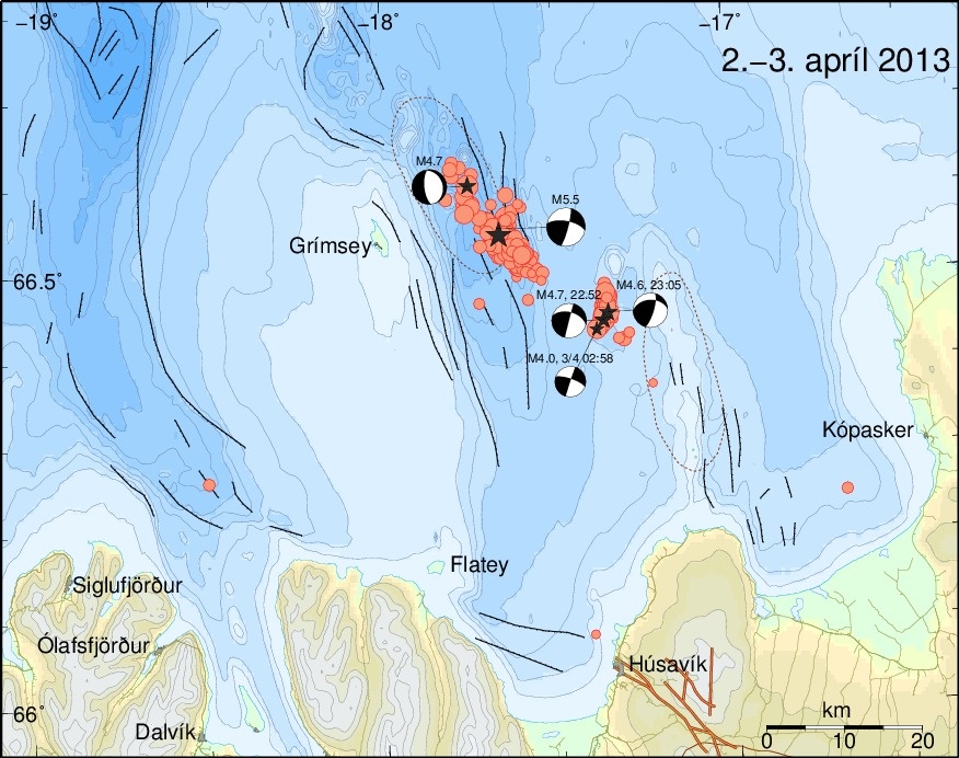
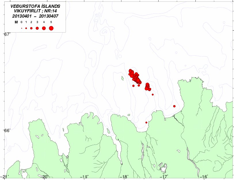
Map showing the largest earthquakes in this swarm. Copyright of this image belongs to Icelandic Meteorological Office.
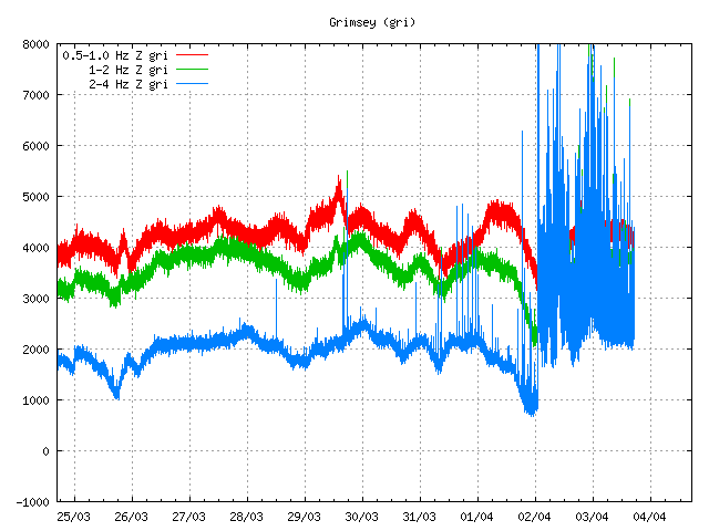
Earthquake activity as it appears on Grímsey SIL station. Copyright of this image belongs to Icelandic Meteorological Office.
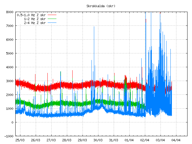
Earthquake activity as it appears on Skrokkalda SIL station. Copyright of this image belongs to Icelandic Meteorological Office.
Reviewed area of earthquake activity on TFZ. This map does not show the current earthquakes. It is few hours old also. Copyright of this image belongs to Icelandic Meteorological Office.
This earthquake swarm is complex and might last for a long time. There is a continued risk of a large earthquake in this area. But there has not been a earthquake larger then magnitude in this part of TFZ since 1910 at least. So this area has a lot of build up stress. Since there has not been a strong earthquake there for a long time. But the magnitude 5.5 earthquake and the following aftershocks have just released tiny amount of the stress that has build up in this area.
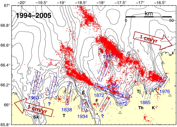
Map showing historical earthquake activity in TFZ. The image is from here. Copyright of this image belongs to Gunnar B. Gudmundsson, Pall Halldorsson, Ragnar Stefansson and other connected people.
For the moment. It is just best to keep watching the activity that is taking place in TFZ. It is impossible to know for sure what happens in TFZ during the next few hours to days.
Other news about this in Icelandic.
Um jarðskjálftana austur af Grímsey (IMO, Icelandic)
Jarðskjálftahrinan við Grímsey heldur áfram (IMO, Icelandic)
Update 1: Here is a focal depth of the earthquakes for the past 15 days.
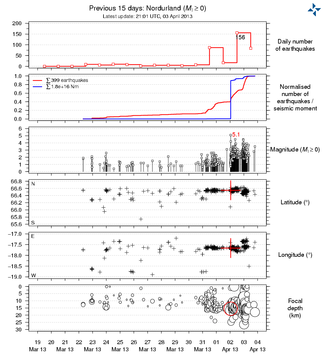
This is the focal depth and number of earthquakes for the past 15 days in north Iceland. This might not show all earthquakes that have happened in this area. Copyright of this image belongs to Icelandic Meteorological Office.
Blog post is updated at 21:17 UTC.
Looking at the depth strength intervals and such obvious grouping, one gets the impression that soemthing, along this fault is is, from beneath like magma is looking for a way out, and o a pretty big scale… is that possible? Is it possible to get the underwater cams to record the floor ans if there are any visible signs. Perhaps see if the floor is rising or hater it is that is doing right now.
For the moment. There are no signs of magma being the reason for this earthquakes. This are normal slip fault earthquakes, along with strike fault earthquakes and normal fault activity.
http://earthquake.usgs.gov/learn/glossary/?term=strike-slip
Jon, I’ve got a dumb question… On many of the maps of iceland, there are light dotted outlines, most of which I would think mark the regions of volcanic centers. On the first and second maps you have shown above, there are two dotted oval outlines. Since you’ve said many times that this isn’t a volcanic area, but a fracture zone, what do these outlines really mark? I’ve always wondered…..
I was speaking to IMO about this today. There is a chance of there might be two volcanoes there. So I might not be entirely correct on this being a non-volcanic area. But the problem here it just is not well known if there is a volcano in this area or not.
There is a volcano closer to the coast line, it is the dotted line just north of the Þeystareykjarbunga volcano. Where the earthquakes are taking place is a different question. I did hear in the news yesterday that there are signs of volcano activity in this area. In this case lava in the ocean floor. Why there is lava on the ocean floor is not well known at all.
That volcano is close to small islands called Mánareyjar on Mánareyjar ridge.
If anyone is wondering how long earthquake swarms can last in this area. In the year 1884 a earthquake swarm started in this area in November. It ended in January 1885.
In the earthquakes swarms during the year 1868 there was a minor or at least eruption in Mánareyjar island area following a earthquake swarm in TFZ. So this is something to keep an eye out for in coming months in my view.
More information. Some of it in Icelandic. Use Google translate if possible.
http://visindavefur.hi.is/article.php?id=146
http://www.volcano.si.edu/world/volcano.cfm?vnum=1703-10=
http://www.sciencedirect.com/science/article/pii/S0012821X01005192 (might be behind a paywall).
I hope this answers your question in part.
There was a 3.6 in Hamarinn tonight and four EQ nearly at the same time. They are not very deep. Are they tectonic? I think Hamarinn gives signs from time to time.