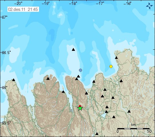
At 19:22 UTC a small earthquake swarm started 14 km east of Akureyri town. The earthquake swarm started with a earthquake with the size of ML3.11 at the depth of 9 km. The area of activity is unusual, but there are none known fault lines in this area that I am aware of. This area is also a bit off TFZ fault zone. This area normally does not have any earthquakes. I am not sure yet if this are intra-plate earthquakes or not, as this area is close to the NVZ (North Volcanic Zone).
This earthquake was felt in Akureyri town by the local people. How well I do not know.

The area where the earthquake swarm is taking place. Copyright of this picture belongs to Iceland Met Office.
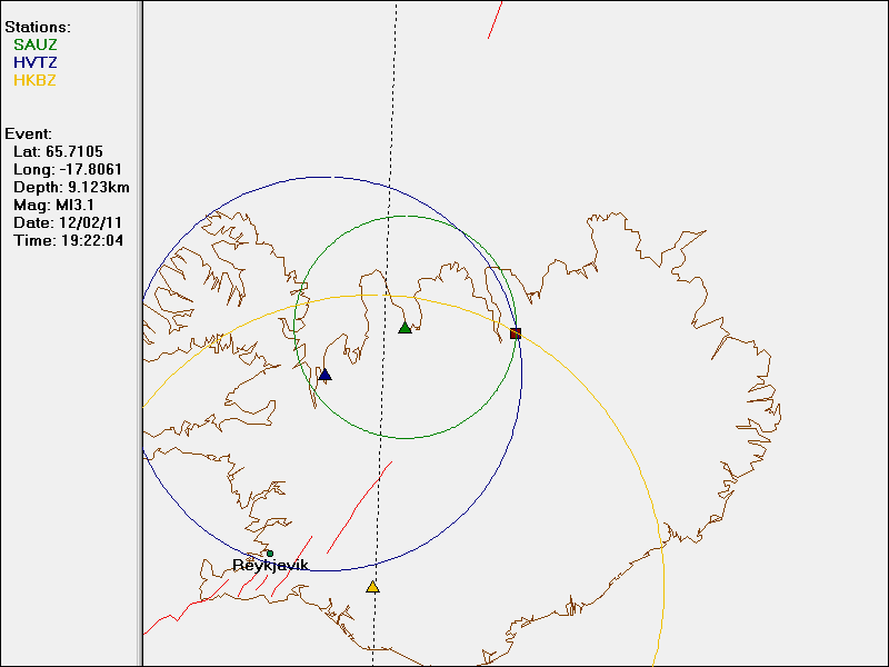
I did record the strongest earthquake on enough geophone to be able to make a plot map from my own software from software called WinQuake that I use to plot earthquakes time, location and depth information with data from Iceland Meteorological Office.

Here is the earthquake location according to my geophones with location data from IMO. This picture is released under Creative Commons licence. See top bar for more information.
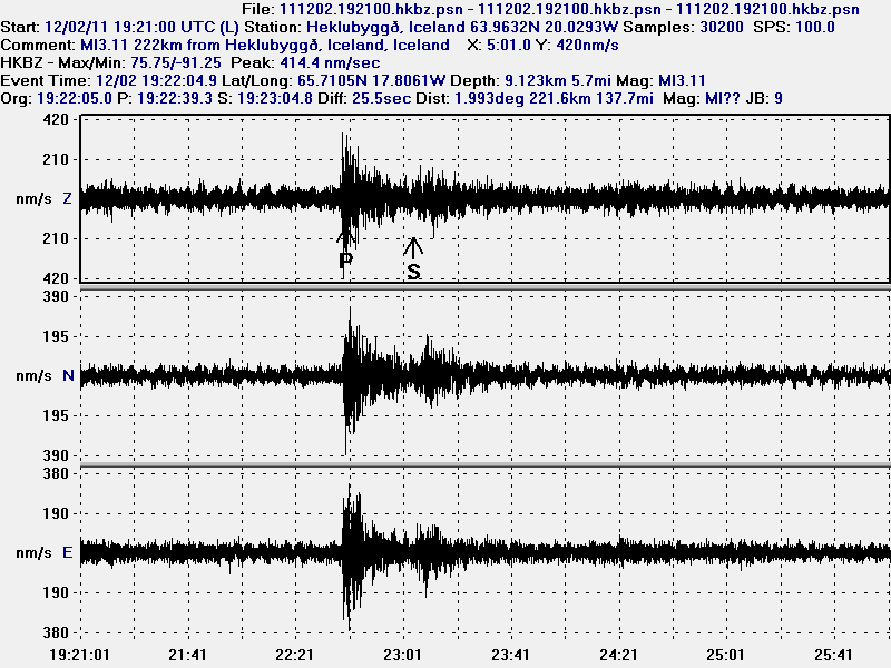
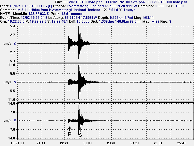
Here are the wave form data that where recorded on my geophones (they can be viewed online here). The Sauðárkrókur geophone is a testing geophone that I am currently running. But it is going to be turned off now in December.

The earthquake as it was recorded on the Heklubyggð geophone. This picture is released under Creative Commons licence. See top bar for more information.

The earthquake on Hvammstangi geophone. This picture is released under Creative Commons licence. See top bar for more information.

The test geophone at Sauðárkrókur village. This geophone is noisy. This picture is released under Creative Commons licence. See top bar for more information.

The strongest aftershock that I did record on my Hvammstangi geophone. The wave form data on Sauðárkrókur geophone where not good for some reason. So I do not display them here. This picture is released under Creative Commons licence. See top bar for more information.
The wave form outside the earthquake are ocean waves. They are strong now and show clearly on my geophone. So they appear even more clearly on the SIL network as higher tremor levels. But that is nothing that looks like a volcanic harmonic tremor.
As for the earthquake swarm. It is hard to know what it means. But more aftershocks in this area for the next few days are not impossible. As has been seen before in areas that suddenly start to make earthquakes after a long break.
Icelandic News reports of this event. Please use Google Translate with care. It does not yet understand.
Jarðskjálfti við Akureyri (mbl.is)
Jarðskjálftar við Akureyri (Rúv.is)
Þrír jarðskjálftar nærri Akureyri (Vísir.is)
Blog post updated at 06:02 UTC on 3 December, 2011. Fixing errors in the text.

Thank you Jon. Giggle does well until it comes across Icelandic! 😉 Great to see the geophones in action even if testing. Money very well spent!
Interesting. Perhaps there is an old fault there that has been inactive for a long time.
Sorry it is a bit late for me, I did not realise that the pix were from your new geophones. Congratulations on getting them installed; the results are good.
How likely is it that magma is on the move there?
There is a minor misunderstanding going on. This data is not from my new geophones. They are not yet operational. The current geophones have been in use for several years now. Hekla geophone was started in the year 2008 in June and Hvammstangi geophone has been in use since 2006. But earlier this year there was a geophone switch in Hvammstangi, as I moved the geophone that I was using to a new one in the Hvammstangi village, but to slightly different location inside the village.
This was because I was moving to Denmark.
The new geophones go up now in December (I hope). I got the computers for them . The plan is to set them up sometimes after 13 December, when I finish school. But lets see how that goes.
Thank you for the clarification. Look forward to seeing the geophones operational.
“I did record the strongest earthquake on enough geophone to be able to make a plot map from my own software.”
Excellent!
Dang, I must have been a bit too sleeping when I wrote this. Fixing this now. As it is wrong.
Cor! Well done Jon. You got that epicentre nicely fixed! My one thought. When you move to Denmark, who will care for your geophones or do they not require much servicing?
The hardware does not need much servicing unless something happens. At least I hope that it doesn’t. I can also always ask the local people for emergency help if I need to.
What is happening at Eystri-Skogar?
http://hraun.vedur.is/ja/oroi/esk.gif
Nothing like it on other stations.
/Tomas
Hi Tomas, You can kind of see nearby such as Alf and MID but it’s not as strong. Weather perhaps?
… … kind of see it, meant to say 🙂
Jon – please take a look at the kvo and mel tremor graphs – this is clearly something going on here over and above generalised background ‘noise’ (although the mel graph stopped plotting properly, but it matches the disturbance pattern at kvo). What might be occuring here?
There is a minor earthquake swarm taking place in Krísuvík volcano.
Do the depths of the quakes have any significance? I remember reading somewhere the crust in some places is only 12k thick.
The crust in this area is about 20 km thick. The depth only tells us where the fault line is taking place.
New blog post about the activity in Krísuvík volcano is up! 🙂