The harmonic tremor in Katla volcano seems to be over. It lasted only short duration after the earthquakes it seems. At least I cannot read anything else out of the data from the SIL station around Katla volcano.
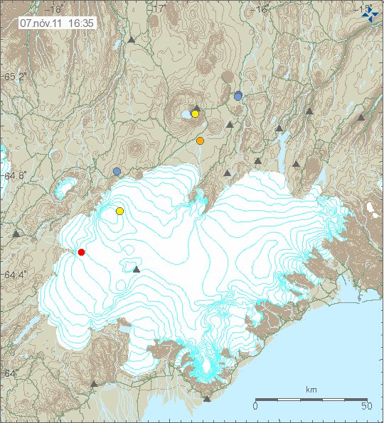
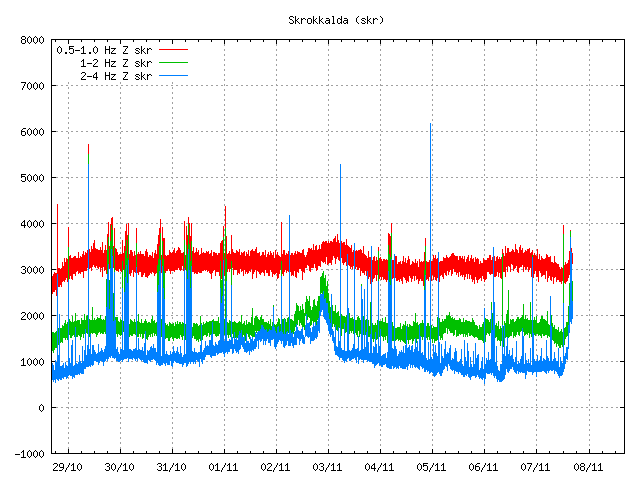
But the harmonic tremor in Hamarinn volcano (part of Bárðarbunga volcano system) seems to be ongoing, as before there is little to no earthquake activity following this harmonic tremor activity. I have no idea why that is. But following this harmonic tremor there was one earthquake with the size ML1.9. But with extremely poor location and size measurement. So the size and depth are subject to a change.

The earthquake in Hamarinn volcano at 16:35 UTC on 7 November, 2011. Copyright of this image belongs to Iceland Met Office.

Harmonic tremor in Hamarinn volcano at 16:44 UTC on 7 November, 2011. Copyright of this image belongs to Iceland Met Office.
Currently the harmonic tremor pulse in Hamarinn volcano is ongoing. So far the harmonic tremor pulse has not reached the level that suggests a eruption is about to start in Hamarinn volcano, as did happen in July this summer (year 2011). But it worth keeping watch on this event in Hamarinn volcano. As more might be coming from that volcano. But its eruption pattern is undocumented so far, as there have been few to none eruptions in Harminn volcano in the 20th century in Iceland.
Update 1: The weather in this area is quite bad from what I can tell. But so far it does not seems to have any effect on the SIL stations. At least I do not see any weather pattern above the normal so far.
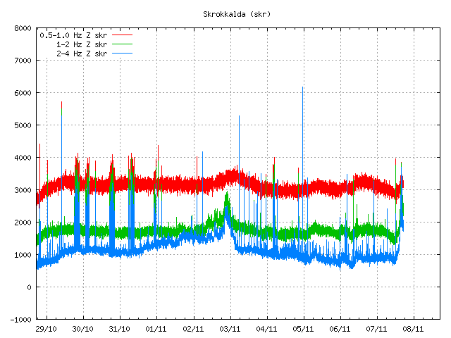
Update 2: There seems to have been a minor eruption in Hamarinn volcano. The harmonic tremor looks like that now. But that is almost the same tremor signal that was in July this summer when a minor eruption took place in Hamarinn volcano.

A clear sign in my opinion that a minor eruption took place in Hamarinn volcano. This activity might continue as it did in July. Copyright of this image belongs to Iceland Met Office.

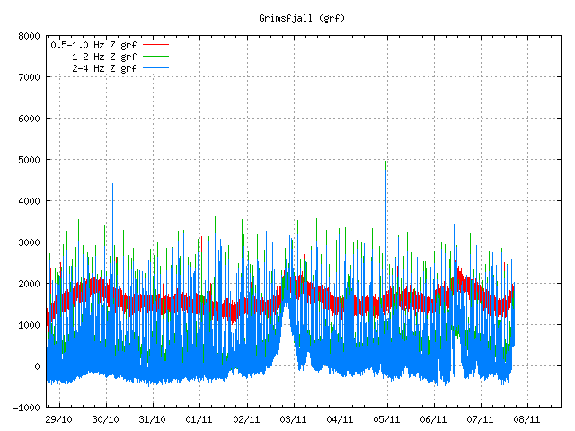
The harmonic tremor sign can also been seen from Grímsfjall SIL station. Not as clear, as this is a small event. Copyright of this image belongs to Iceland Met Office.
A glacier flood should be expected from this event in the next few hours. At least I am assuming that given the glacier cover in the area. It is also a risk that this eruption is going to continue for the next few hours and drop off between as it did in July.
Blog post updated at 16:55 UTC on 7 November, 2011.
Blog post updated at 17:06 UTC on 7 November, 2011.

Oh and the ReCaptcha – I don’t know if you’ve noticed that there are 3 buttons to the right of the space that you enter them – if you click the top one you get a fresh recaptcha – and you can keep doing that until you can find something that’s easy to read.
Sometimes I get loads of greek – or something, hit the button, and now I have something I can enter easily.
94,108,179 arrtle
I must say, this is extremely helpful. Thanks!
yes agreed, very helpful, hopefully I will never fail a recaptch exam again. 😉
Very often it just helps putting in sth ressembling the captcha like A for Δ or O for greek Ω.
About the weather at Hamarinn: That seems to be ALWAYS BAD. 😉
I rarely see a day wothout winds below windforce 7 there, even windofrce above 9 is normal pratice there. I have been there during one of my summertrips, and can tell you from own experience, it is not a very hostile region, we decided not to stay there (we were there by Land Rover, sleeping in tent: no fun there). Fierce winds are rule, no exception. That probably has to do with being a sandplain bordering glacial area.
Iceland is in general very windy, and mountain and glacier tops are extremely windy very often. Yesterday winds topped 120km/h at places in mountains and in the south coast. The most windy places as far as I know are the Westman Islands and the top of Eyjafjallajokull.
Hi Guys!
After all it seems that the tremor decrease.
What is trouble me is the tremor of the other stations that got an pick at 3 to 4 am.
In my opinion this decrease is due to an regular pillow lava eruption. No gases. Around La Resigna at Bob location.
But other vents might have some gas explosion.
On the other hand the 1 to 2 Mag. activity has renew. I suppose that is due to lava reservoire enlargement due to lava pass volume.
Am I correct?
I think what you see between 3 and 4 am is the earthquake in Japan
(M 6.9 2011/11/08 02:59 Depth 209.5 km)
yap, you’re right…..stupid me
Anyhow then remain the rest of my deduction
On the regular eruption, the gassing might have decreased, or it is just a lull in the eruption. We will know sooner or later 🙂
this is a great blog, informative,interesting and entertaining, it also stops me feeling like a wierdo, its obviously not just me thats obsessed by volcanoes and earthquakes and how mother nature works 🙂
In response to some late night/early morning discussion betwixt some of you lot….
Right, come on then, own up- which one of you crazy boggers was it??!
http://www.bbc.co.uk/news/science-environment-14184722
A bit more vigorous one over at Katla:
Tuesday
08.11.2011 09:50:42 63.594 -19.149 1.1 km 3.2 90.07 2.9 km WNW of Hábunga
Revised to 3.0 but very shallow at 0.1km
Its also visible on Jóns helicorder. The 10.18 quake is not, so this will be downgraded to 1.something or smaller.
A nice photoalbum in Canarias 7 now:
http://canarias7.es/multimedia/galeria.cfm?id=6864&n=1
Not so much of the volcano, but more of living with the volcano. Btw, I would like to hear the conversation between the policemen in photo nr 6… 😉
I don’t know if anyone posted this link before, but here is an interesting paper on the effects of flank collapse:
Title: The effects of flank collapses on volcano plumbing systems
(Let’s see if I was able to make the link active–it’s been awhile)
Earthquake-report.com have managed to get a better webcam, where you actually see the volcano! 🙂
“If you do not see the jacuzzi, it may be down for a while, but the image will refresh every minute or so and when i new burst is sending the geyser-like column to the sea level, the jacuzzi can be well seen.
How to see the webcam image ? Click here (http://www.meteolaspuntas.es/) and id asked for a userid and password, type : telefonica and restinga. “
IT IS TOOOOOOOOOOOOOOOOOOO BUSYYYYYYYYYYY!!!
Really? I’m inside there now, and dont have any problems watching or updating. Maybe try again in a few minutes?
Imagen en tiempo real cada 10 sg. Tanganasoga. Orientación S. LatN27.78/LongW-17.99. Posible saturación de banda debido exceso de conexiones..
Thanks to Mr. Atilano who managed to do what the authorities couldn’t – to put up a webcam in 2011… 😉
“Mr. Atilano, an El Hierro board member living at Frontera and geologist, the owner of the El Golfo webcam at meteolaspuntas.com, was asked by Earthquake-report.com to cooperate and to direct a webcam to the Las Calmas sea. Mr. Atilano told us that he will do his utmost best to get it done within a couple of days.
Well, we are so happy that he kept his word.
The action at the moment is limited BUT WE HAVE A LIVE IMAGE FROM THE JACUZZI closest to La Restinga now. The image is HD and of superb quality.”
(http://earthquake-report.com/2011/09/25/el-hierro-canary-islands-spain-volcanic-risk-alert-increased-to-yellow/)
Going via earthquake report article I didn’t have to type in the password and the link worked fine. Though it was too busy when I went in via the link provided above that (by Mirri the first time).
It’s a nice picture of the port with at present a white area of water that is presumably the jacuzzi sitting (note I’m just guessing the distance by eye) at about 1.5km (or 1 mile) off shore.
We’ve had some proper distances given previously – how does that compare?
Edward,
The image refreshes every minute or so. Joke just told mer that the jacuzzi is getting more active every 10 minutes
Not me 🙂
Teco Peco was the intended recipient of the above.
Katlas 3.2 looks OK on the tremor graphs and indeed IMO only revised it down to 3.0. I think I am getting the hang of this 🙂
Today is the day for El Hierro perhaps, I cannot see the webcam at the moment, can anybody else?
Now sometimes when I refresh the webcam I get “too busy” also, but after refreshing a few times I can see it again.
Nope 🙁 I tried, I failed, several times 🙁 🙁
Are there any still images of todays Jacuzzi off the webcam anybody please? 🙂
http://jordif1.viewnetcam.com:8080/SnapshotJPEG?Resolution=640×480&Quality=Clarity&View=Normal
this is connecting for me at the moment though it does involve pressing F5 quite often.
telefonica and restinga are the username & password
http://i41.tinypic.com/11glp8k.jpg
current webcam image
I collected some screenshots here:
http://www.flickr.com/photos/69578968@N06/sets/72157628082079610/detail/
something strange happened with that link… i put in on two lines now, to see if that helps (just copy and paste it together)
http://www.flickr.com/photos/69578968
@N06/sets/72157628082079610/detail/
now i cannot access the webcam anymore, but as soon as I can I will upload a few more.
Still cannot access the webcam, but I’ll keep trying. Also added Alisons photo (12.08) to the set, and got a better link for it:
http://www.flickr.com/photos/soysofi/sets/72157628082079610/detail/
New blog post about the earthquake in Katla volcano this morning is up!
Update 08/11 – 13:17 UTC :
– We have lost the signal of the La Restinga webcam. May we ask Telefonica, the Spanish telecommunications giant, to help Mr. Atilano with unlimited capacity as hundreds or even thousands of people are trying to watch the webcam. We trust that the image will be back soon.
From El Hierro twitter
Nos informan que Presidencia no quiere instalar webcam porque perjudicaría el turismo, da imagen de inseguridad y peligro
Translated
We report that president does not want to install because it would hurt tourism webcam gives image of insecurity and danger
These guys should probably take a look to Iceland. And how much webcams have been installed during the last eruptions.
this is stupid , Presidencia are nineteenth century , that is embarrasing!!!!
Well, he is completely wrong on that one; a webcam would generate interest which would help tourism.
URGENThttp://www.canarias7.es/
18:28 Residents of El Pinar just felt a strong jolt. “It has moved around,” says Rosa Rodriguez from El Hierro. The signals have intensified: the smell of gas in the area of Puerto Naos (300 meters above La Restinga), possibly CO2, the earthquake was felt at 17:51 has had an intensity of 3.4 according to the National Geographic Institute. The bubble does not stop bubbling.
You can’t smell CO2. Period.
SO2, yes. H2S, yes. You can smell both of those.
H2S – Rotton eggs. SO2 – Burnt matches.
http://www.youtube.com/watch?v=gn7fWSAZhLY the last video