Yesterday and today there where two tremor spikes in Katla volcano. This follows a higher then normal background noise that I cannot directly trace only to wind as I did first think. What is going on is not clear, but it remains a bit of events just before the July 1999 minor eruption (suspected). But it has been speculated by scientist that event was related to inflation event deep inside Katla volcano systems. But the actual fact remains unclear. More information on the event in July 1999 can be read here (in Icelandic).
Pictures from the year 1999 of the harmonic tremor event in July that year.
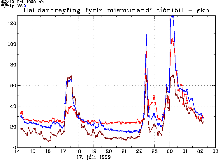
The harmonic tremor spikes in July 1999 in Katla volcano. Copyright of this picture belongs to Iceland Met Office.
There was also special note on this tremor chart here from skh SIL station (now gone). But in the year 1999 this signal was most clear on Snæbýli SIL (snb). But today this signal appears to be most clear on Goðabunga SIL station and Eystri-Skógar SIL (esk) SIL station. I do not know what the difference is. But it clearly is something.
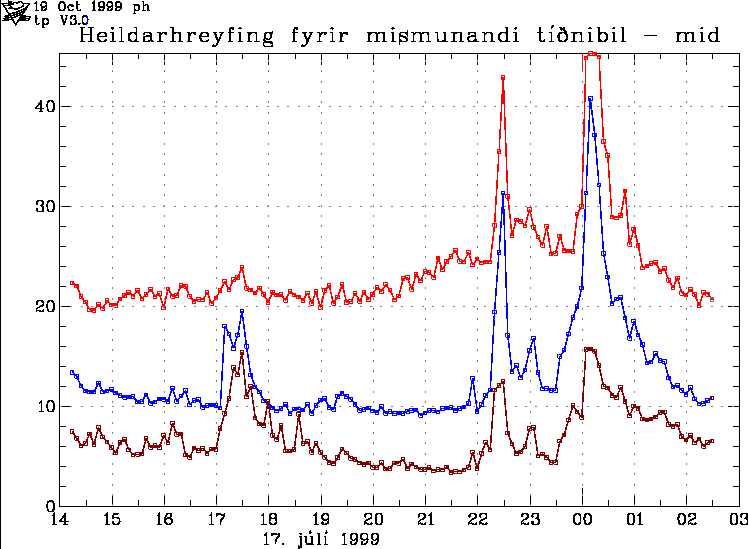
The harmonic tremor spikes in July 1999 in Katla volcano. Copyright of this picture belongs to Iceland Met Office.
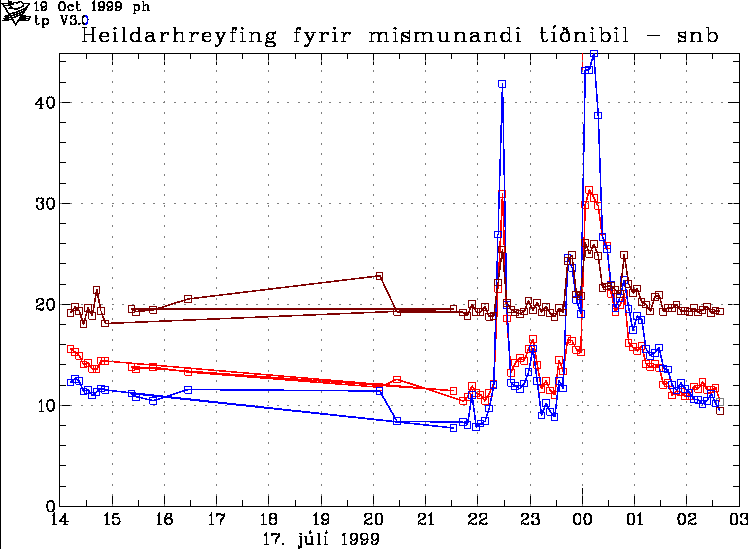
The harmonic tremor spikes in July 1999 in Katla volcano. Copyright of this picture belongs to Iceland Met Office.
Please note that all earthquakes have been cleared from this old SIL tremor plots.
Current day activity in Katla volcano looks like this on the SIL stations where it is most clearly seen.
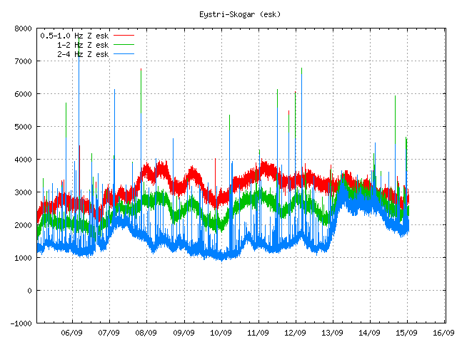
Odd spikes can be seen here on this tremor plot. I do not know what they are. Copyright of this picture belongs to Iceland Met Office.
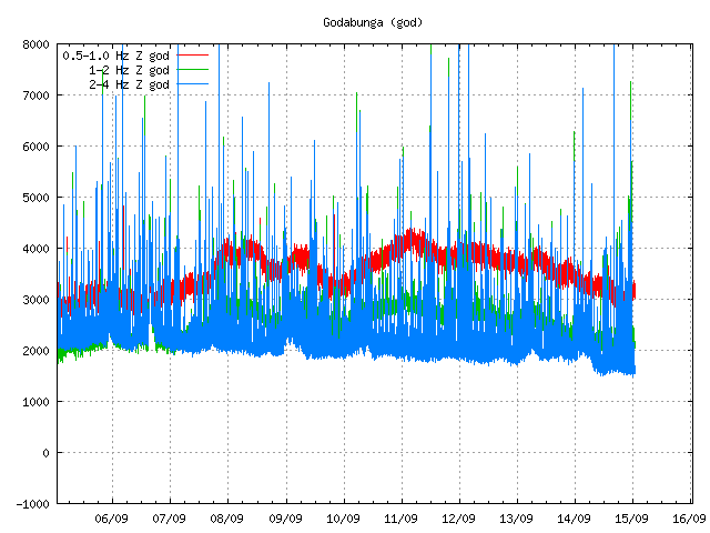
Hard to see spikes can be seen on Goðabunga SIL station. They are the same as from Eystri-Skógar SIL station. Copyright of this picture belongs to Iceland Met Office.
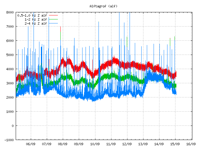
Same as above. But stronger then on Goðabunga SIL station. Copyright of this picture belongs to Iceland Met Office.
It is hard to know for sure what this signals means. But I am sure that this signals are going to mean something someday. But when is hard to know.

I have a question regarding magma tubes. and their diameters.
Which of these scenarios are true, more likely?
1) the diameter increases, because the hot running magma melts the rock in tube walls and it gets pushed up along with the magma.
2) the diamater decreses, as the magma is cooled somewhat by relatively colder tube walls and it gradually sticks to it.
3) both factors work simultaneously and the diamater stays relavively the same even over a long timespan.
Ehm… Try asking Boris Behncke or Erik Klemetti that question… I think they might now.
Number two might explain why older volcanoes erupt more seldomly and eventually become extinct, even though younger ones are more far away from the rift zone, as it’s the case with Tindfjallajökull and Katla or Eyja.
Problem is just that there are very ancient volcanos that are still wildly active.
I think it has to do more with them loosing the deep connection that fed them with fresh magma. You are kind of forgetting the most important question, is the volcano fed via globules of magma that finds a crack, or is it fed from the core?
One should always remember that there are examples of volcanos that are millions of years old and are still active.
There are also examples of volcanos that keap their tubing open. I saw a documentary on Swedish television during the summer of an Icelandic volcano that they climbed down into and followed the still open tubes far down into the earth.
I think all 3 of your examples can be true, but can change over time, and varies from one volcano to the next.
Slight problem with the assumption that Tindfjallajökull and Katla or Eyja being are far away from the rift zone.
Ridge/Rift jumps are fairly common in Iceland.
A line through Katla and Eyja then extending down through Vestmannaeyjar may be the formative stages for another of these jumps.
Currently the entry point for the Mid Atlantic Ridge is up the spine of the Reykjanes peninsula but there is a lot of evidence that it once tracked through Snæfellsnes. The future area may be Vestmannaeyjar. (in a few million years)
“Iceland provides a fitting transition from ridge jumps to rift jumps in that it is phySically and eompoaitlon1ly intermediate between oceans and continents. Although the Icelandic rift system is a direct continuation of the oceanic ridge to its north and south, it appears to be more complex, having 2-6 active, subparallel rift zones, instead of the single spreading center of the ocean ridges. Abandoned rift zones are identified in eastern (extending south from the Holaheidi peninsula) and west-central (from Skagi peninsula south to the current rift zone at Thingveillir) lceland, and it is posstble that each of the peninsulas on Iceland’s northern and western shores represents an ancinet rift. Each of the identified rift zones has a relatively short period of activity, and some, such as the closely spaced and parallel Grimsvotn and Torfajokull zones, are acthe contemporaneously.”
[Note: OCR’d and checked for errors, but there could still be some errors in my transcription, see the original document if there are apparent errors]
Title: Continental rift jumps? Authors: Wood, C. A.
Journal: Abstracts of Papers presented to the conference on Processes of Planetary Rifting. A Lunar and Planetary Institute Topical Conference held December 3-5, 1981, in Napa Valley, CA. Co-sponsored by LPI, the American Geophysical Union, the National Science Foundation, and NASA. LPI Contribution 457, published by the Lunar and Planetary Institute, 3303 Nasa Road 1, Houston, TX 77058, 1981, p.56
Bibliographic Code: 1981LPICo.457…56W
http://articles.adsabs.harvard.edu//full/1981LPICo.457…56W/0000056.000.html
Probably should have read
“…could still be a lot of errors in my transcription..”
I really think the Torfajokull/Hekla/Tindfjallajokull/Katla/Eyjafjallajokull and Westmannaeyjar, are the formative stages of the future rift spreading zone.
Or maybe it could jump again, and a future rift spreading zone could be developing further east, at the southwest of Grimsvotn and Oraefajokull.
And if anyone is into German…
Kleifarvatn ist eine vulkanische toilettensitzgeschirrspülmaschine…
Müssen ein schönes Wochenende!
I don’t descriminate any language. 🙂
Very nice!
Bidet?
Hi Carl,
where did you find this one? Giggle?
Sie zu
There is water level rising since yesterday almost all around Myrdasjökull, 20-30cm if i read the plots correctly, heavy rain? Also rise in conductivity on v581.
This mean anything?spectacular
There has been a lot of rain the last couple of days, and before that it had been a bit of a dry spell in the area.
The reason for the conductivity going up is because the water is containing more di-electric material. Normaly one measures that to see if there is material flushed out by a pre-eruptive Jökulhlaup, but this time I think it is just all the ash-material that was blowing around during the dry spell that has ended up in the water. Ash contains a lot of di-electric material…
I was suspecting something like that, thank you.
word spectacular in the end was for captcha, just wrote it to wrong place…oops…
I do not get it why people are using captchas when you just can click on “log in” and then create a user account… Then you are free as a bird of the captcha-swamp 🙂
May sound stupid, but I see NO login link at this page!
Under Categories to the right you have a section called Meta, klick on Log in.
Voila 🙂
don’t see anything like that Carl. I’d log in if I could.
Well I just found it, with the search function of the browser (!), search for Meta.
It works. Thanks to Carl.
If you search (hit Ctrl-F) for “RSS” in the page, it should be very near to those words.
Please use anything else then older browser on this web page. As you might be getting a cut down version of this blog if you are using older version of web browser.
Thankyou for that, I’m now registered. Many times in the past I’ve tried to popst a comment, but couldn’t get past the Captcha trap. Only 3 attempts at captcha and I’m now registered.
Because there are spam-bots running around the Internet that can exploit the typical “log in” and post their spam. I’m thinking Captcha is more secure and easier for Jon to manage.
The log in link, for those that can’t find it: http://icelandgeology.net/wp-login.php
I personally like playing the captcha game.
The video from lake Kleifarvatn (link posted by Chris earlier today) is very impressive! Even if you do not understand the spoken text, I don’t either. Must be seen.
It shows a lot of activity under and above the surface. Seems like most of the lake, of what is left of it, is boiling. Or, is the “vapour” escaping gases?
What does it smell like, I wonder…
Once more the link:
http://www.youtube.com/watch?v=5sEnmJlkw6M
Its both: Its gas and boiling water. And it smells like rotten eggs.
So it is sulphur coming up, probably. And it is very hot. Does this say anything about the possibility of an eruption in this area, or are the heat and the smell always present near the lake?
By the way, as a child I wanted to go to Iceland to have a warm bath outside in the middle of the winter. In Norway, we learned to swim in glacial water with a temperature mostly under 10 degrees, worst experience was about 5 degrees. Brrrrrrrrrrrrrrr
Is the lake disappearing through evaporation due to the heat. Or is it draining through a (new) fissure?
Drought mostly.
Re Kleifarvatn
No, its not “only” drought
Kleifarvatn is 97 m deep. After the big earthquake in 2000 the water level diminished and has shrunk 20% since then (from http://is.wikipedia.org/wiki/Kleifarvatn)
Original source of the wikipedia data is http://www.mbl.is/mm/gagnasafn/grein.html?grein_id=622453 and take a look at the picture.
Still haven’t found anything on how much the water level has declined this year or what the water level is / was recently but the latter article says water is running through fissures (that saturate at some point) and that this is not the first time that this has happended ( 1633 )
The geothermal area in Seltún changes and the water level changes after that.
I guess its the last.
I do not know why I got to think of this when I was thinking about Lake Kleifarvatn. Or perhaps I just enjoy confusing people on fridays.
But here is a bit of party music…
http://www.youtube.com/watch?v=kQShZ2Tnshk
You know… What is seen can not be un-seen.
But it can be aurally deprogrammed
Du Hast by Rammstein
http://www.youtube.com/watch?v=My0HQ0QkGLQ
Emigrate by Emigrate (Kruspe)
http://www.youtube.com/watch?v=b7NPm69xsyg
Yes, that’s very confusing :P, thanks btw on directions to register, I never even looked for it, since it wasn’t on top of the page…
And a bit OT.
A friend of mine went through Germany this week on his way to a meeting in an undisclosed country for an undisclosed reason, to discus an undisclosed matter with an undisclosed person(s). 😀
He/she sent me a pic of a street sign there that had a silhouette of a woman holding the hand of a child, with one of those international “don’t do it” diagonal bars across the image. We mused over the possible meaning. My interpretation was “No kid walking”
Any one have an idea what this sign actually means? And, if I am correct, does this also imply that they may have leash laws too?
This sign means “end of the pedestrian zone” (there is also a beginning sign). I remember that there was a man (with hat) with a child before. But that probably has to be very reminiscent of child molesters …
My First post here.wonderful Blog!!
OT
End of pedestrian Zone is right.
Search for Pictures at google “fussgaengerzone”
Them. You will See it.
Beginning of this Zone is Same Picture in a blue Circle.
Every town in Germany has such a Zone…
Has digging started again? A new quake at same spot:
Friday 16.09.2011 17:32:22 64.050 -21.372 0.4 km 0.6 73.7 1.9 km NE of Hellisheiðarvirkjun.
No it’s my ruddy moles erupting in the lawn again!!!
Also noticed somewhere woodpigeons are a rare visitor to Iceland, can I export a few hundred of the b….y things!
I won’t ask what you are doing to eradicate the problem that is causing detectable earthquakes.
No I don’t harm ’em – tolerate them until I catch one then take it to a set-aside field and release – i’m a bit Buddhist (ish), pidgeons just shoo’em
Oh, so it’s the moles causing all the tremors. Clearly they have tough moles in Iceland.
Very OT….Ah! I am a biologist and love moles¬ Talpa europea
Icelandic name Moldvarpa . What I would dearly like to know is …How did the first mole get to Iceland? Ireland has no moles presumably because there was no Land bridge to Europe after the last Iceage.
Is there something wrong with ruv/katla cam or is my laptop going haywire again, haven’t got pic from there since yesterday? dataflow seems ok, but no picture.
It was my laptop….
The weather was very bad anyway, but you missed this:
http://s1112.photobucket.com/albums/k499/sissel59/Katla%20webcam/?action=view¤t=vlcsnap-2011-09-15-10h46m57s66.png
Found this site somewhat interesting to say the least, but I can’t find any more for other areas, anyone know if ISOR sell paper copies to a decent scale, say 1:50k or if any are available elsewhere please? Or does one contact them directly?
http://geothermal.is/maps/geological-map-southwest-iceland
http://www.forlagid.is/?p=568313
Thanks JR
Carl, are you doing diving?
I only did snorkeling at Silfra. I look forward to those two fissures near Ásbyrgi and Litlaá.
Yes I do dive, or more to the point, I used to dive. I kind of lost the interest after plodding around in cold and murky waters to much.
I had to post that to my facebook. Almost defies comment. Thanks?
Captcha: oreseern wit – feels appropriate somehow…
Ya, I DO log in, but I kinda like the CAPTCHAs.
I was thinking on all the recent activity in Iceland and it occurred to me that the whole rift might be getting ready to make a statement. Rippin’ rift.
Oops that was in reply to Carl’s devastating video…Posted me down here.
Ah… good that I did not make everyone blind with that one…
There is an even worse one that contains milk… 😉
Magnitude 6.6
Date-Time Friday, September 16, 2011 at 19:26:42 UTC
Saturday, September 17, 2011 at 04:26:42 AM at epicenter
Time of Earthquake in other Time Zones
Location 40.288°N, 142.727°E
Depth 36.3 km (22.6 miles)
Region NEAR THE EAST COAST OF HONSHU, JAPAN
Distances 108 km (67 miles) ESE of Hachinohe, Honshu, Japan
149 km (92 miles) ENE of Morioka, Honshu, Japan
177 km (109 miles) ESE of Aomori, Honshu, Japan
574 km (356 miles) NNE of TOKYO, Japan
Location Uncertainty horizontal +/- 15.3 km (9.5 miles); depth +/- 4.2 km (2.6 miles)
Parameters NST=447, Nph=447, Dmin=195.9 km, Rmss=0.82 sec, Gp= 32°,
M-type=regional moment magnitude (Mw), Version=7
Source Magnitude: USGS NEIC (WDCS-D)
Location: USGS NEIC (WDCS-D)
Event ID usc0005vv7
Spike in all stations.
I don’t think this earthquake can be seen on the SIL charts as they don’t show high enough resolution for that? It can however I believe be spotted here on the PNSN (Pacific Northwest Seismic Network). http://i.imgur.com/WARjF.gif
Link to this webicorder: http://www.pnsn.org/WEBICORDER/VOLC/SHW_SHZ_UW_–.2011091612.html
This is my weekend off. So no new blog posts this weekend. But I am going to monitor for comments so all comments get trough in timely manner. But they might get a little delayed during the day and somewhat into the evening.
Have a great weekend. Hope all is quiet in Iceland.
Enjoy your weekend off Jon. Remember though- things tend to get quite interesting in Iceland at the weekends! So keep an eye on things for us.
Tremor trend spikes in sil stations SKR and near, not where it comes from or is due to weather
OT.
I’ve heard the rumblings that the recent Virginia quake was intended to “get Washington’s attention” and most sane people point out that the quake fit well within normal occurrence rate for the region.
It does.
But when you munge around in the data and you note that a lot of the energy was pointed directly at Washington DC… it sort of make the hair on the back of your neck stand up.
http://i53.tinypic.com/33wku2t.png
X-axis is the bearing from the quake, Y-axis is the distance from the epicenter, the Z-axis is the peak acceleration of the quake.
BTW, most of the faulting in this region is oriented along that line, so it is most likely not supernatural… maybe.
(And now the on-topic connection. I’m trying to derive the minimum size quake that a person would be aware of with out the aid of instruments. I think it’s Mag 1.2, and that the reference is from somewhere at Berkley. I can’t find it, so I’m trying to come up with my own estimate. This fall back on that “can you get off of Helka in time” meme.)
Good Morning Jon . Have a very good weekend.
Friday night seemed quiet. Maybe Katla has not been out partying!
As regards Hengill area. The old whaling cry of ” There she blows” comes to mind …. again!
There seems to be downward movement in all gps stations except SOHO
http://strokkur.raunvis.hi.is/~sigrun/KATLA11.html
she’s breathing…
Jon takes the weekend off, we’ll probably have at least a couple of interesting events.
I do not get any connection with the Katla webcam today, not on http://www.ruv.is/katla and not on mms://3.efstaleiti.rs.ruv.is/katla/ with the VLC Media player. – Am I the only one, or is the cam down?
Hope it will not last for long.
I don’t either
Mila’s webcam of Katla seems ok 🙂
http://live.mila.is/katla/
They are probably working on it.
It’s the sheep’s fault!
@Both
http://live.mila.is/katla/http://live.mila.is/katla/
It gets all black, at Katla’s. But Hekla’s is working fine.
http://live.mila.is/katla/
This one is working fine too.
There isn’t much to be seen there actually, looks like very bad weather.
Are there any webcams covering the new quake spot on the south flank of Katla?
Nice couple of quakes at Austmannasbung. The magnitudes are especially interesting.
@Poisonman, yes the regular mila cam does cover the spot.
http://live.mila.is/katla/
Think Katla misses Jon already!
Saturday
17.09.2011 13:15:03 63.646 -19.074 1.1 km 2.7 90.05 7.4 km N of Hábunga
Saturday
17.09.2011 12:55:04 63.649 -19.072 1.1 km 1.9 90.01 7.8 km N of Hábunga
Saturday
17.09.2011 12:48:04 63.650 -19.082 1.1 km 2.5 90.01 7.8 km N of Hábunga
Saturday
17.09.2011 11:42:59 63.645 -19.139 21.8 km -0.0 64.23 5.5 km E of Goðabunga
Saturday
17.09.2011 11:09:20 63.651 -19.075 1.1 km 0.9 90.01 8.0 km N of Hábunga
Saturday
17.09.2011 11:08:01 63.650 -19.068 0.1 km 1.4 99.0 7.9 km NNE of Hábunga
Saturday
17.09.2011 10:30:24 63.545 -19.010 1.5 km 0.3 33.56 5.9 km SE of Hábunga
Saturday
17.09.2011 05:26:09 63.649 -19.056 1.1 km 1.1 90.02 8.0 km NNE of Hábunga
English news about new stations that were installed around Katla last wednesday.
Oops! Link:
http://www.icelandreview.com/icelandreview/daily_news/?cat_id=29314&ew_0_a_id=382295
Etna on my mind
Did you watch this on the TV? Did they say that the webcam site for Katla was one. Could be, they need to make more time encase of eruption and have to move some people away from a area. The floods could happen in a different area than before. More information that points to the pass active period for the summer is abnormal.
There Lady K goes again. New swarm, new spikes.
Weekend mode.
That glacier in the centre of the Ejaf Milacam really looks like the skull of a hideous ancient Norse being just waiting for………………
looks more like an elephant head to me. 🙂
Does anyone know if that is a rather extensive period of harmonic tremor showing on God tremor chrt?
Not really but Jon’s Hekla helicorder does show to the untrained eye some possible harmonic tremors this afternoon – but I could not say where they occured or what caused them. Many of the SIL stations were showing signs of increased activity this afternoon.
We need Jon to interpret these.
Wow you have one heck of an imagination, haha.
Well, Pieter can’t you see a crashed dragon – head, ridges each side of the glacier its shoulders and the main glacier on each side its wings – just waiting for mother Katla to come and help and relight its fire. Easy to see how ancient stories start, especially after a drink or two!!
Looks even better full screen!!
This rock looks like a Elephant, its in Vestman islands.
http://www.flickr.com/photos/goggith/4938169351/
http://www.flickr.com/photos/goggith/4291086957/in/set-72157624363562735/
http://www.flickr.com/photos/59264938@N00/4830576501/in/photostream
Jon- Not to beat a dead horse, since most people think events on Earth are isolated from everything, but I noticed a similarity between the tremor graph of vestmannaeyjar and the Sunspot Cycle graph found at spaceweather.com. The tremor graphs you show from the 1999 activity and this year look very similar and that reminded me of this connection.
Waves of energy, sound, quantum particles, water… as above, so below.
Why on earth should these particles just influence the magma? And not get absorbed by the upper layers including the water?
Err…, it’s more fun if they didn’t? Betcha most people have forgotten that old coot Faraday and his cage, van den Graf generators and other boring schoolbook physics. 😉
In other words: All the fundamentals of modern science.
Correct, science is the scourge of wishful thinking and to the great ire of their originator, many beautiful thoughts founder upon the hard rocks of science.
Ooops, forgot the first line of defence – the van Allen Belt, so sorry, mea culpa.
RuffleTheTeacher says:
September 17, 2011 at 18:09
“… as above, so below…”
You know, that is getting to be one hell of a worn out and thread bare cliché.
Pretty much along the lines of the intellectually corrupt idea of the Sun having a direct influence on seismic activity.
http://i54.tinypic.com/k2gryv.png
Thanks for this plot. We should keep it at a prominent spot and cite it every time, when this nonsense comes up again.
A good idea Chris. These pseudo scientific ideas seem to be taking the place of the urban myths.
…as you stomp. you stomp hard…
Should be the creed of those pseudo-science-stomping-graphs of yours 😉
Weather must be really bad as it is dark early at Jökulsárlón, Gullfoss, & Geysir (Mila’s webcams).
Even though it was and is bad weather in south Iceland, I think there could have been some harmonic tremor in Katla today. It is visible in several stations. I think this is related to the 2.7 earthquake today.
The other interesting fact is past few days had also a couple of harmonic tremor in Skrokkalda station, close to Hamarinn volcano.
I wonder what is going on with Almannagjá at Thingvellir, its starting to fall apart,
the crack gets bigger every day.
http://www.visir.is/almannagja-er-eins-og-svissneskur-ostur/article/2011709169949
The Chinese president was the last one to drive down Almannagjá 🙂
Fönix says:
September 17, 2011 at 22:49
“I wonder what is going on with Almannagjá at Thingvellir, its starting to fall apart,
the crack gets bigger every day.”
Thanks for the link.
But, stating the obvious, it is a rift, that’s what rifts do. If a road built down the center of a crack starts to deteriorate and collapse due to the crack getting wider, build the road in a different place. The only way to actually stop it, would be stopping the two plates from moving apart. I don’t think that’s gonna happen any time soon.
Re-route the road, put a parking area near each and and a bike/walking path so that people can go up and see the thing, and call it a day. Problem solved.
This actually might be signs that a new rifting episodes are about to start in this area. Therefor new eruptions on the Reykjanes peninsula. But that is only a guess, based on best available data that I got.
To the lay mind it is very hard to accept the possibility that all activity to the SW, S, SE and now with Hengill also E of Reykjavik, natural or otherwise, will have no end result other than a plethora of quakes and the odd opening of a crack. Given the proximity to Reykjavik, I’m continually astounded that people are far more interested in and concerned by a few quakes in or near Katla than with what’s happening on the Reykjanes Peninsula over the past few years. Even a very hypothetical and highly unlikely VEI 6 at Katla is no more than a nuisance compared with what a much smaller eruption at, say, Kleifarvatn or Hengill could imply. Even a for Iceland small-ish fissure eruption with a release of ~1 cu km of magma/lava over several months is far more serious than Katla’s worst.
In my opinion.
I have walked up and down this rift Almannagjá many times in the space of ca 30 years and have never noticed any significant change, the plates have been slowly drifting apart like everyone knows, but for some reason they seem to be picking up speed.
The water level of Kleifarvatn is now dropping 5 mm a day and has dropped a lot for the last few years.
This is similar to what happened in the big quake in 2000, when lake Kleifarvatn dropped by 4 meters.
The area around Sveifluháls in Krísuvík has risen about 7 cm in the last 16 months, there has been considerable activity in the area, possibly caused by magma.
All this activity is connected to movement of the tectonic plates.
Since this video was shot in 2009, Kleifarvatn has dropped 2-2,5 meters.
http://www.youtube.com/watch?v=kQQWu-uhxno
Much of the geothermal activity shown in the video is now on dry land.
I also wonder how smart is is to allow this Fracking experiment currently going on at Hellisheiði, i think as its quite obvious to any thinking person that we are seeing considerable increase in volcanic activity in Iceland, so it might me smart to avoid deliberately causing earthquakes in rift zones close to big volcanoes.
I think that we could build a road or walking path along the Almannagjá rift, but we will never be able to keep the tourists out of the rift, its just too interesting to examine. I have walked up and down this rift many times, but i guess i will look more carefully where i step next time.
As far as I followed up the news on the crack in Thingvellir, one of the theories is, that this crack is rather old. It was blocked by sand and gravel which has been washed away with time. I have been there a number of times and haven’t noticed anything.
While trying to learn more about Almannagjá at Thingvellir, I ran across the following article, something even I can understand:
Geology and tectonics of Þingvellir
http://notendur.hi.is/oi/geology_of_thingvellir.htm
Here is show about Iceland and the rift zone and other things 🙂
http://www.youtube.com/watch?v=diqH6mVICTg&feature=mh_lolz&list=FLeweNRQOStNFoWvI7X-ePEg
Very interesting video (How the earth was made: Iceland), many topics well explained and beautiful pictures.
@ Brenda Thank you . A nice link there. Excellent for those starting to study Iceland’s geology.
@Lurking, You have common sense! Unfortunately many who are decision makers lack this rare gift!
@ Irpsit , Skrokkalda & Askja seems to be showing more activity in it’s area than Katla SILs this week end.
I didn’t know there was another camera set up on katla now? Well F_ck my sister’s Black Cat’s Arse! We have a new camera! Hoooray!
http://live.mila.is/katla/
Please watch your language. You got a camera of Katla. That is all good. But there are better words to be used.
While cursing has it place and time. I do not think that this forum here is the right place and time for such words.
Seems to be a harmonic tremor starting at Katla
http://hraun.vedur.is/ja/Katla/god_trem.gif
Could also be weather related. Looks much what happened around 2 September.
No, this is just the result of strong winds.
@ Jon
I might be thought as ‘of the old school’ but could you tell contributors to curb their language as a number of ladies also enjoy this site and we don’t need profanities.
You need to get a life if your day consists of imperiously cantankerous remarks like that. Think yourself lucky that you didn’t have to grow up the way I had to where a good week would be being called everything under the sun, but avoiding any bruises on the back. This is the internet. If any ‘lady’ doesn’t want to see any profanity, they will have an impossible task of avoiding it by going online.
So you’re just being a haughty vexatious old Xanthippe. Still, now I know what the ‘c’ stands for ay! I’ll refrain from typing it, as you might well have a heart attack!
Now on top of making yourself look ill mannered, you have also made yourself look immature, well done Kindle, and yes, its probably best if you do refrain from posting. I grew up in a working class mining town in the north of england were every pause in a sentance was replaced with a swear word, but no matter how rough and ready we were we did realise that there is a time and a place for language like that, this is not the place.
Please, none of this type of argument here. All such posts are going to get deleted without warning if this escalates.
@ alan c Thank you for the above remark about crude language. I accept much but there are limits.
@ Jon & Alan Thank you. Appreciated.
I’ll second that. Nothing to do with being a lady. This just isn’t the place for it.
All that swearing & it’s the same view.
http://hraun.vedur.is/ja/Katla/god_trem.gif Can anyone tells what’s going on? All frequencies are piking up fast!
This is extremely bad weather.
what do you think -bad weather or man made eq again?
http://en.vedur.is/earthquakes-and-volcanism/earthquakes/reykjanespeninsula/
Had an idea for an earthquake chart. Attention Luring, if interested! 😉 Although I expect I can get the data for a chart using USGS quake data.
It is the density of earthquakes (# per earth volume, where volume would be cubic km, for example) as a function of depth, world-wide.
Basically I was wondering how magma placticity (and temperature and pressure) affected the frequency of earthquakes occuring. So the idea is count the earthquakes in concentric shells (depth ranges) of the earth and then divide those numbers by the volume of earth in each shell. That is quite different than simply looking at earthquakes as a function of depth … instead, it is the probability of an earthquake occurring in a given volume of earth as a function of depth (for some time period). And that could be done for different magnitiude ranges, such as M 5+ or M 6, etc.
Has anyone ever seen a chart of that before?
Oh, might be interesting to see the difference for voulmes under ocean areas versus under land areas.
It is possible that you would have to take into account the different types of faults; for example, mid ocean ridges / divergent plates where the magma is supposed to be nearer the surface might not behave the same way as convergent plates. It would be an amazing piece of research.
Pretty much what is done by people who look at this sort of stuff as a living.
My data is limited to what is publicly available, and that usually comes out in flat file format. Partitioning/grouping the events by lat-lon boxes is easy, but when you try to pick an irregular area it gets to be a time intensive operation.
As an example, I did a selective pull on all quakes from the USGS catalog for the area 100 km either side of the San Andreas fault. It took over 40 separate queries. Then the data had to be placed into the same file and duplicate events found and removed. The amount of overlap for the queries had to be enough that I had complete data, but not so great that I spent all day pulling duplicates. It took the better part of a Saturday before I was comfortable with the data.
And that was for a segment that is about 2400 km long and roughly straight.
Imagine trying to do that for the entire length of the Mid-Oceanic Ridges or the various subduction zones. Then factor in the slight issue of where do you place the boundaries of your data pull? How do you treat the ridge itself as it transitions to the transverse fracture zone areas and then back?
Yeah, theres a lot of stuff that can be learned from it. Actual researchers (who are formally trained and get paid to do it) look at stuff like this. My only issue is when some money grubbing “Journal” charges a premium price just so you can get a peek at what the research says… some of which was paid for by you and I with our tax dollars.
Sort if makes you want to hit something eh?
If taxpayer funds went into the research, we, as the ones who footed the bill, own it. A “journal” that tries to profit off of charging us to see data that we funded, should be drawn, quartered, immolated, and buried alive. (in whichever sequence gives the most misery)
Me, I just plot what data I can get my hands on that doesn’t involve me taking up a second career.
How about a plot of energy release per cubic km instead?
http://i55.tinypic.com/2q246bp.png
All quakes M4.5 and up, binned into 1 km depth shells to 700 km depth. Sum of energy / shell volume.
And the version with fewer spelling errors
http://i54.tinypic.com/2vnnin9.png
http://strokkur.raunvis.hi.is/~sigrun/SOHO.png
Inflation? Data glitch?
Only time will tell, still not enough data points…
Magnitude Mw 6.8
Region SIKKIM, INDIA
Date time 2011-09-18 12:40:47.0 UTC
Location 27.84 N ; 88.18 E
Depth 10 km
Distances 88 km NW Darjiling (pop 123,797 ; local time 18:10:47.4 2011-09-18)
70 km NW Gangtok (pop 30,700 ; local time 18:10:47.4 2011-09-18)
50 km NW Mangan (pop 1,464 ; local time 18:10:47.4 2011-09-18)
Can this big spike came from this earthquake! It’s at same time…
It was quite shallow and a long way from Iceland – so not sure.
Sunday
18.09.2011 13:24:39 63.906 -19.035 0.3 km 1.1 41.04 9.5 km S of Landmannalaugar
Sunday
18.09.2011 13:23:40 63.926 -19.052 1.5 km 2.0 90.04 7.2 km S of Landmannalaugar
Don’t know, but god is kind of strange.
Could it be only attributed to the winds?
http://hraun.vedur.is/ja/oroi/god.gif
Wind + India EQ.
A 6.8? Well could be so, by the time it occurred.
Torfajokull is having a little quiver
Sunday
18.09.2011 13:24:39 63.920 -19.049 0.5 km 0.7 99.0 7.9 km S of Landmannalaugar
Sunday
18.09.2011 13:23:40 63.924 -19.050 2.0 km 2.2 99.0 7.4 km S of Landmannalaugar
http://hraun.vedur.is/ja/oroi/sly.gif
http://hraun.vedur.is/ja/oroi/hau.gif
http://hraun.vedur.is/ja/oroi/vat.gif
The current tremor spikes are most probably from the 6.8 India earthquake.
The Mw6.8 earthquake did leave it’s signature everywhere around the globe.
http://www.simnet.is/jonfr500/earthquake/othersten.htm
http://www.simnet.is/jonfr500/earthquake/tremorusgsen.htm
interesting quake
13:23:39,8 63,982 -18,429 29,3 1,9 66,86 13,6 km SV af Laka