The earthquake activity in Skaftafellsfjöll mountain (part under Vatnajökull glacier)

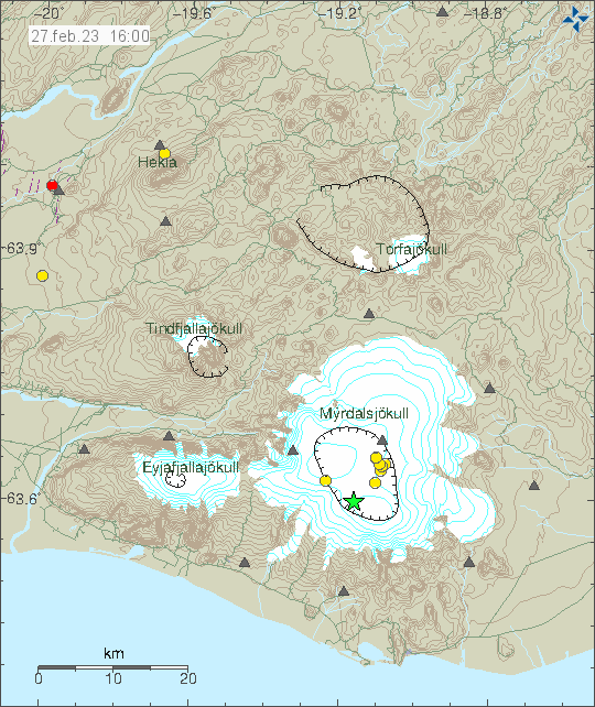
Since May 2011 there has been an earthquake activity in mountain called Saftafellsfjöll. This is slightly north of Öræfajökull volcano and south of Grímsfjall volcano. This earthquake activity is now permanent in this area it seems. Some of it might be glacier quakes, but most of the earthquake activity there is not, because of the depth this earthquake activity is happening at.

Earthquake activity in Skaftafell in Skaftafellsfjöll mountain. Shown as blue, orange and yellow dots on the map of Vatnajökull glacier. Also on this map is earthquake activity in Askja volcano and Herðubreið shown with red dots.
Earthquake activity in Skaftafellsfjöll mountain. Copyright of this image belongs to Icelandic Met Office.
One year worth of earthquake data from Skjalftalísa program on Icelandic Met Office. It shows a clear concentration of earthquakes in Skaftafellsfjöll mountain over this time.
Earthquake activity in Skaftafellsfjöll mountain for 365 days. Picture is from Skjálftalísa on Icelandic Met Office website. Copyright of this image belongs to Icelandic Met Office.

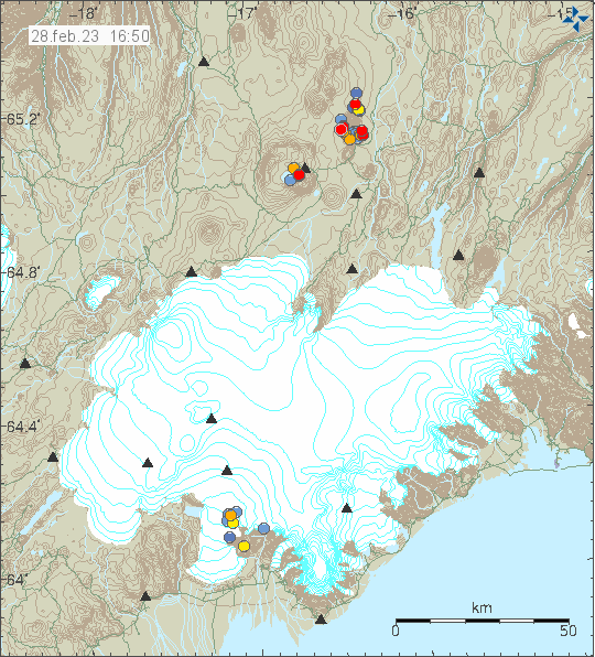
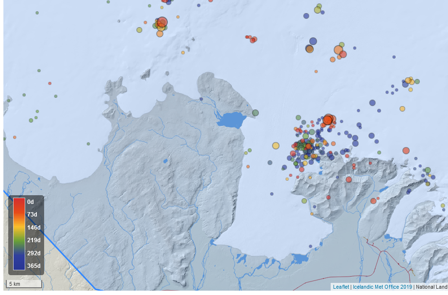
I don’t know for sure what is going on. This earthquake activity clearly shows that something is going on in this part of Vatnajökull glacier. It is my unverified opinion that there is a volcano there. Its not documented and map only show a extinct volcano in this area. This is unlikely to be earthquake activity in extinct volcano, its not impossible, what makes this unlikely is that this earthquake activity happens regularly and has been going on since May 2011. There is ice quake activity in this same area, but some of this earthquake activity is both deep and being located in areas with no glacier. If those are not measuring errors or something like that (I find that unlikely in many cases). I don’t think there’s going to be an eruption in this area, at least not for a long time if it ever happens. This earthquake activity might have been going on for a lot longer then from May 2011.

– This is not an registered or confirmed volcano in this area. Unless there’s an eruption, it might be a long time until a confirmation happens.

Earthquake activity in Katla volcano

Yesterday (26. February 2023) and today (27. February 2023) there was an earthquake activity in Katla volcano. This is mostly normal activity in Katla volcano and no signs of an eruption or that an eruption is about to start. Largest earthquake in this swarm had a magnitude of Mw3,2. I don’t know if it was felt in nearby area.

Yellow dots and green star in Katla volcano caldera that is under Mýrdalsjökull glacier that is shown in white on this image, along with other nearby volcanoes. The askja of Katla volcano is shown as elongated circle.
Earthquake activity in Katla volcano. Copyright of this image belongs to Icelandic Met Office.

There is no change in harmonic tremors or other activity in Katla volcano. That means this is just an earthquake activity and there is no sign that an eruption is about to happen.

People in eastern Iceland told to prepare for possible eruption in Askja volcano

Rúv News is reporting that people in eastern Iceland should look up information on how to deal with possible volcano ash from Askja volcano. This is an general advice to people in eastern Iceland because of possible eruption in Askja volcano, that can start without any warning or little warning. There is some risk of eruption in Askja volcano that might create an ash cloud, but there is also a chance that if Askja volcano erupts that the eruption is going to be a lava flow eruption, close to what happened in Bárðarbunga volcano in 2014 to 2015 eruption.

There is a possibility that the eruption from Askja volcano is going to go south, into the new Holuhraun lava field and craters after the Bárðarbunga volcano eruption of 2014 to 2015. There has been some earthquake activity in that area in recent weeks and there might be a weakness in the crust at that location that was not sealed during last eruption. What happens is only going to be clear once an eruption starts and until then its all just speculation.

Icelandic News about Askja volcano

Íbúar á Austurlandi ættu að kynna sér leiðbeiningar um öskugos (Rúv.is, Icelandic)

Earthquake swarm close to Geirfugladrangur on Reykjanes ridge

Today (21. February 2023) an earthquake swarm started close to Geirfugladrangur on Reykjanes ridge. This is possibly in another volcano than Reykjanes volcano that is just east of this location, this is because of distance and its unlikely that Reykjanes volcano extends this far south. It has no other name than Geirfugladrangur. Largest earthquake in this swarm had a magnitude of Mw3,1 and this earthquake swarm is ongoing and stronger earthquakes are a possibility.

Earthquake swarm on the Reykjanes ridge, marked by orange and green star were the largest earthquake took place. A lot of yellow dots close to Reykjanestá area.
Earthquake swarm on Reykjanes ridge. Copyright of this image belongs to Icelandic Met Office.

This earthquake pattern seems to indicate that a magma dyke intrusion is taking place. This area of the Reykjanes ridge last erupted in 16th to 18th century and has been quiet since.

Light sized earthquake in Bárðarbunga volcano

Today (21. February 2023) at 08:41 UTC an earthquake with magnitude of Mw4,9 took place in Bárðarbunga volcano. This is because of inflation that is now happening in Bárðarbunga volcano and has been going on since end of Holuhraun eruption in 2015. Earthquakes with this type of magnitude are going to happen once or twice a year until Bárðarbunga volcano is ready for next eruption and that can take decades. There are going to be smaller earthquakes between larger earthquakes. According to the news, this earthquake was felt in Akureyri.

Green star and red dots in Bárðarbunga volcano inside Vatnajökull glacier. Few dots in other volcanoes in this part of Iceland.
Earthquake activity in Bárðarbunga volcano. Copyright of this image belongs to Icelandic Met Office.

Last time this happened it took 112 years between eruptions in Bárðarbunga volcano. With the quiet period between 1902 and until 2014. Shortest time between eruptions seems to be around 40 years, but most eruptions happen between 90 to 112 years from last eruption. Based on the data from Global Volcanism Program on Bárðarbunga volcano. There is a lot of uncertainty in this data, so this might be shorter from what it looks like in the data.

I’ve switched to using standard definition for earthquake magnitudes, as shown here (Wikipedia). This is for clarification and simplification when I am writing about earthquakes.

Earthquake swarm north of Herðubreið mountain

Today (17. February 2023) at 09:26 UTC an earthquake with magnitude of Mw3,5 took place around 4 km north of Herðubreið mountain. This earthquake seems to have started an earthquake swarm in that area. It is unclear if this earthquake activity is connected to inflation that is taking place in Askja volcano.

Green star north of Herðubreið mountain. This is east of Askja volcano. Few dots of smaller earthquakes also in Askja volcano.
Earthquake activity in Herðubreið mountain. Copyright of this image belongs to Icelandic Met Office.

There has been increase in earthquake activity at this location in Herðubreið mountain, but why is unclear.

Strong earthquake swarm north of Kolbeinsey island [Updated]

Today (14. February 2023) at 01:24 UTC an earthquake swarm started around 70 to 90 km north of Kolbeinsey island. It might be in Kolbeinsey island. Largest earthquakes recorded at the writing of this article had a magnitude of Mw3,5 according to Icelandic Met Office. EMSC is reporting two earthquakes with magnitude of mb4,5 at the writing of this article.

Two green stars far north of Iceland in the ocean. Showing the location of the earthquakes north of Kolbeinsey island. This is all view map of Iceland and shows all the other earthquakes that have taken place in Iceland for the last 48 hours.
Earthquake activity north of Kolbeinsey island. Copyright of this image belongs to Icelandic Met Office.

Distance from land makes it difficult for the SIL network that Icelandic Met Office runs to detect the smallest earthquakes. This means there can be a lot more going on that appears on earthquake maps. There’s always a chance of stronger earthquakes in this area north of Iceland.

Update
Update at 16:50 UTC on 14. February 2023

Icelandic Met Office has finished reviewing the earthquake activity north of Kolbeinsey and around eight earthquakes with magnitude above Mw3,0 took place. Largest earthquake had a magnitude of mb4,6 according to EMSC. Information about that earthquake can be found here.

Ten green stars far north of Iceland showing the earthquake activity north of Kolbeinsey island. Other earthquakes that also happen in Iceland are visible on this map.
Earthquake activity far north of Iceland. Copyright of this image belongs to Icelandic Met Office.

This earthquake activity appears to be over, but distance from seismic detection networks in Iceland prevents detection of smaller earthquakes that might be happening at this location.

Eruption expected in Fagradalsfjall volcano this year (2023) or next year (2024)

It was reported in Rúv News that eruption is expected to happen in Fagradalsfjall volcano this year (2023) or next year (2024). When those eruptions happen is impossible to know. But before any eruption there’s going to be a large earthquake swarm as happened before the eruption in March 2021 and in August 2022. Fagradalsfjall volcano before the eruption in March 2021 had not erupted for 6000 to 8000 years. That means it unclear how the volcano is going to behave and its going to take a while until that is figured out, but for now it is probable that Fagradalsfjall volcano is going to work in similar way how Krafla volcano erupted between the year 1975 and 1984. With the difference that eruptions in Fagradalsfjall volcano are possibly going to last longer, based on data from other volcanoes on Reykjanes peninsula. This might go on for the next 10 to 20 years, with eruptions and quiet time period between them. Currently Fagradalsfjall volcano is in a quiet time.

This does not rule out eruptions in Reykjanes volcano (west of Fagradalsfjall volcano) and Krýsuvík-Trölladyngja volcano (east of Fagradalsfjall volcano) in next few years. Neither of those volcanoes have erupted in 700 to 900 years and at the writing of this article, don’t show any clear signs that they are about to erupt. Reykjanes volcano has had a lot of dyke intrusion activity since 2019, but no eruptions so far. Krýsuvík-Trölladyngja volcano has not had any dyke intrusion activity. Volcanoes east of Krýsuvík-Trölladyngja volcano, Brennisteinsfjöll volcano and Hengill volcano are currently quiet, but that might change without warning if magma starts to find path up those volcanoes.

Earthquake south of Kolbeinsey island

Yesterday (10. February 2023) at 16:25 UTC an earthquake with magnitude of Mw3,1 took place around 41 km south of Kolbeinsey island.

Green star and yellow dots at the location of the earthquakes south of Kolbeinsey island.
The earthquake south of Kolbeinsey island. Copyright of this image belongs to Icelandic Met Office.

This earthquake was far from any populated areas of Iceland and was not felt for this reason.

Strong earthquake swarm in Reykjanes volcano on Reykjanes ridge / Reykjanes peninsula

This earthquake swarm is ongoing at the writing of this article and information can change without warning. The largest earthquake recorded by automatic magnitude of Mw3,7 at the writing of this article. Around 30 to 40 earthquakes have happened so far, but that number might change quickly. This earthquake activity has some signs that it might be happening because of magma intrusion in the area, out in the ocean but signals are not clear.

Three green stars and red dots on the left down side on the map of Reykjanes peninsula, the earthquake activity is happening out in the ocean on the Reykjanes ridge.
The current earthquake activity on Reykjanes ridge. Copyright of this image belongs to Icelandic Met Office.

This earthquake activity is in the volcano Reykjanes, that volcano goes into the ocean and is on dry land. Making possible future eruptions both explosive and flowing magma at the same time. To date, Reykjanes volcano only has had earthquake swarms and no eruption. When that is going to change is impossible to know.