Magnitude Mw5,4 earthquake 3,2 km east of Grindavík town

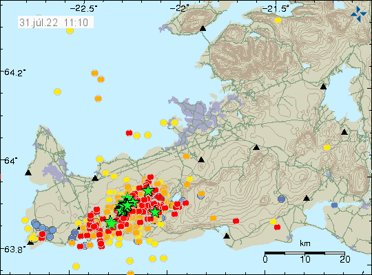
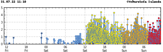
Today (31-July-2022) at 17:48 UTC an earthquake with magnitude of Mw5,4 took place 3,2 km east of Grindavík town. This earthquake was felt over a wide area of Iceland and all the way to Westfjörd in few towns that are there. Damage has been reported in Grindavík town, with cold water main breaking and damage to house items, damages to houses is unclear at the writing of this article. New news reports show that items in grocery stores have been thrown out of their shelf.

The red dots continue to grow on the Icelandic Met Office earthquake map. Green stars are also many on this same map of Reykjanes peninsula
The earthquake activity on Reykjanes peninsula and close to Grindavík town. Copyright of this image belongs to Icelandic Met Office.

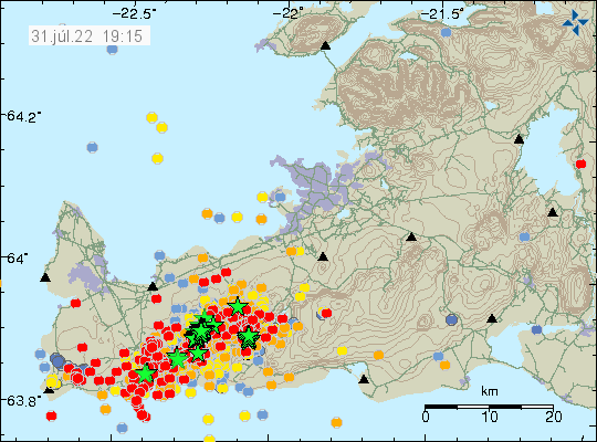
This earthquake is a fault earthquake and as such not directly connected to a magma movement in Fagradalsfjall mountain, however, the magma movement in Fagradalsfjall mountain is the engine that makes this earthquake possible in this location. There is a chance that two magnitude Mw5,4 earthquakes took place at the same time east of Grindavík town. This was mentioned in Rúv news about the earthquake, such earthquakes are a lot more complicated and harder to get correct magnitude for. More earthquakes like this can be expected in this area or closer to Reykjavík city at any time without warning.

Update on the earthquake swarm in Fagradalsfjall mountain (Krýsuvík-Trölladyngja volcano)

This is going to be a short update because the situation is constantly changing. This update is written at 12:07 UTC on 31-July-2022.

At the writing of this article at 11:32 UTC no eruption has started in Fagradalsfjall mountain or nearby area. Over 3000 earthquakes have been recorded in the last 24 hours in and around Fagradalsfjall mountain since the earthquake activity started yesterday (30-July-2022). There have not been any major changes in the crater in Fagradalsfjall mountain, it does seem to release more gas than normal. That is at least how it appears, if that is real or not I don’t know.

A lot of red dots on Reykjanes peninusla as the heavy earthquake swarm continues. A lot of green stars in a line close to Fagradalsfjall mountain, showing the location of the strongest earthqaukes
Heavy earthquake activity on Reykjanes peninsula. Copyright of this image belongs to Icelandic Met Office.
The time index of the earthquake activity for the last 48 hours. Since 12 yesterday, there have been a continuos earthquake activity. Now the dots are yellow, orange and red after the age of the earthquakes
The earthquake activity in the last 48 hours. Copyright of this image belongs to Icelandic Met Office.

I think this might be a stronger activity than last year, but if that is correct estimate is a wait and see. There has not been any major change in GPS location and that suggest that the area is as inflated as it possibly can be. It is impossible to know when the magma breaks up in the crust, but earthquake activity suggests that it has reached the depth of 2 km, meaning the magma has moved up a lot in the last 24 hours, since this earthquake activity started on the depth of 8 km yesterday.

Donations

Please remember to support my work with donations. Thanks for the support. 🙂