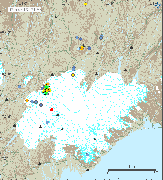
Bárðarbunga volcano continues it earthquake activity and it has now been a year since the eruption in Bárðarbunga volcano ended in Holuhraun (article I wrote about it can be found here). This activity (image) took place on 2-March-2016.

The earthquake activity in Bárðarbunga volcano. Green stars are earthquake with magnitude above 3,0. Copyright of this image belongs to Iceland Met Office.
Largest earthquakes in this swarm had the magnitude of 3,1, 3,3 and 3,6. Other earthquakes where smaller in magnitude. The reason for this earthquake swarm seems to be a developing weakness in the north and western part of the caldera. Activity in south part of the caldera seems to be crust adjustment to this weakness (stress changes). The weakest area is long one (I didn’t find information on how large the caldera is, but it is large). This weakness is going to continue to develop until an eruption happens or the magma finds it self a new path and that is more likely than an eruption taking place in the caldera rim, however I cannot rule out an eruption in the caldera at this point. This is all just wait and see situation at the moment. Interesting earthquake also took place in Hamarinn volcano, it had the depth of 13 km and magnitude of 0,7.
Deep earthquakes also took place in Tungnafellsjökull volcano. That earthquake had the magnitude of 0,8 but depth of 17,9 km. Suggesting that some stress changes at depth are taking place. In this case I doubt magma created the earthquake.
If an ash eruptions takes place in Bárðarbunga volcano, the resulting ash fall would be devastating (besides the following glacier flood). Last time larger eruption took place in 1477 half of Iceland got covered in volcano ash (that’s 50% of land), the volcano ash eruption in 1711 covered north Iceland and large parts of east Iceland. In 1711 to 1729 total of nine glacier floods took place and the source of them is believed to be Bárðarbunga volcano. Glacier floods from other volcanoes (Grímsfjall, Kverkfjöll, Þórðarhyrna, Hamarinn) are also highly dangerous. The volcano ash had thickness up to 100 meters next to the eruption area in 1477 (see map in link 1).
Source 1: Hvaða tjón gæti mögulega hlotist af gosi í Bárðarbungu? (Icelandic)
Source 2: Hvað eru mörg gos þekkt í Bárðarbungu og hefur orðið mikið tjón af þeim? (has gravity map of Vatnajökull glacier, Icelandic)
