Minor earthquake activity in Öræfajökull volcano

Over the past few weeks there has been a slight increase in earthquakes in Öræfajökull volcano. Due to glacier quake activity I’m only using earthquakes that have confirmed depth of 1,5 km or deeper. This earthquake activity is minor and doesn’t suggest that an eruption is imminent, it however does suggest that something is going on.

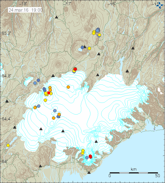
160324_1900
Öræfajökull volcano is to the south on this image (two red dots). Copyright of this image belongs to Icelandic Met Office.

This activity has a long history, it started happening in 2012 at the earliest that I know of and has been going on slowly since then. Öræfajökull volcano did go from having no earthquakes and up to having two to five earthquakes a year. Sometimes more. There are clues in this activity that magma might be starting to push it self up into the volcano, but at the moment it doesn’t seems to be going far up into the volcano. Based on the current depth and low seismicity in Öræfajökull volcano. I don’t expect this to change any time soon. Since most of the time, at least for the moment there is little to no earthquake activity taking place in Öræfajökull volcano.

Donations

Please remember to support my work with donations. Thanks for the support. 🙂

Earthquake activity in Bárðarbunga and Grímsfjall volcanoes

Yesterday (17-March-2016) an earthquake swarm took place in Bárðarbunga volcano. This is a weekly cycle at the moment in Bárðarbunga volcano so older readers are used to seeing and read about it already. This started in September 2015 (for the new readers) after the eruption in Holuhraun ended in February 2015. This activity suggest that magma has started to flow into the magma chamber in Bárðarbunga volcano again at faster speeds than before the eruption in Holuhraun. The exact rate is difficult to know, since the magma that started the eruption in Holhraun had been building up in Bárðarbunga volcano since 1970-ish and part of that time earthquake recording was poor or did not exist in Iceland or parts of it until 1995 when the SIL network was created by Veðurstofa Íslands.
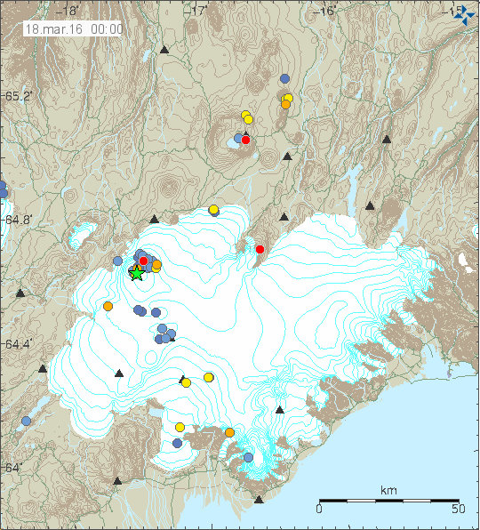
160318_0000
The earthquake activity in Bárðarbunga and Grímsfjall volcanoes. Copyright of this image belongs to Iceland Met Office.

The largest earthquake this week had the magnitude of 3,4 while other earthquakes that took place had smaller magnitude. The second largest earthquake had the magnitude of 2,8. Other earthquakes where smaller in magnitude. It is also interesting that part of the earthquake swarm aligned it self along north-south fault in the eastern part of the caldera. That is a new feature, either a weakness is forming at this location or something else is up. This area has around 300 – 500 meter thick glacier on top of it and an eruption at this location would be extremely bad. The glacier flood from eruption at this location would mostly go down Jökulsá á fjöllum glacier river. Other flood locations can’t be ruled out (I’m not an expert on glacier floods and I do have limited knowledge of the landscape under the glacier).

Grímsfjall volcano

It has been five years since Grímsfjall volcano erupted in a largest eruption in 140 years for Grímsfjall volcano. Over the past few weeks there has been a slight increase in earthquake in Grímsfjall volcano. At the moment this doesn’t mean an eruption is imminent, the thing however about eruptions in Grímsfjall volcano is that they happen suddenly and without warning. Normally eruption happens in Grímsfjall volcano every 3 – 5 years on average, sometimes its shorter and sometimes its longer between eruptions.

Notice on Böðvarshólar geophone station

For the longest time now I’ve been having 3G connection issues with Böðvarshólar geophone station. The problems include poor signal, little bandwidth. The poor signal leaks into my recording of earthquakes, making them bad and extremely noisy and that makes them less usable for me. I am going to attempt to improve this situation but if that fails I will have to turn the station down. Since the cost of getting a good antenna for this location is too high and the solution takes too long to implement anyway. I will post a notice if I take down the Böðvarshólar geophone station. If it happens, it is going to happen before I move to Denmark.

Article updated on 18-March-2016 at 13:31 UTC. Minor spelling error fixes.
Earthquakes north of Kolbeinsey Island

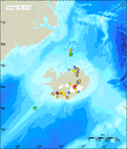
Today (16-March-2016) there was an earthquake swarm around 110 km north of Kolbeinsey Island. At this location there are no registered or known volcanoes, there however might be one, but it is difficult to confirm. This earthquake activity however appears to be related to an rift valley that is at this location, rather then any volcano activity.

160316_1740
The earthquake activity around 110 km north of Kolbeinsey Island. Green star shows the location of the largest earthquake. One magnitude 3,0 earthquake was deep on the Reykjanes Ridge (green star). Copyright of this image belongs to Iceland Met Office.

Largest earthquake in this swarm had the magnitude of 3,1. That magnitude is possibly an underestimate of magnitude due to distance from the SIL network. Other earthquakes have been smaller, but one earthquake had the magnitude of 2,9. That earthquake might have had a magnitude above 3,0 in reality. I suspect more earthquake activity has taken place without being detected by the SIL network.

Donations

Please remember to support my work with donations. Thanks for the support.

Deep earthquakes in Askja volcano (15-March-2016)

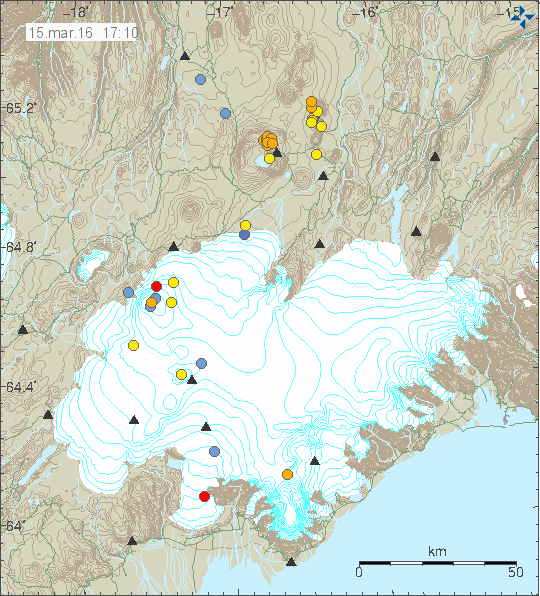
Yesterday (15-March-2016) an earthquake swarm took place in Askja volcano. This was an deep earthquake swarm, with deepest earthquake having the depth of 18,7 km and the shallowest earthquake with the depth of 14,9 km. The earthquake swarm took place inside the volcano and there are clues that suggest it has it’s origin. This has been happening regularly since 2010 and after the Bárðarbunga volcano dyke getting close to the main magma chamber in Askja volcano the activity has slowly been increasing. This activity is not above background levels and nothing suggests that an eruption is about to happen any time soon.

160315_1710
Askja volcano is located to the north-east of Bárðarbunga volcano. Copyright of this image belongs to Iceland Met Office.

For the moment the progress and the change in Askja volcano is slow, but that might change if the magma inside the system finds a pathway to the surface. If an eruption does happen I’m not expecting anything big, just a lava eruption that is going to go on for few days to weeks. Unless the magma gets into contact with water, creating a short term explosions. This is only a speculation, but Askja volcano is an active system and as such anything should be expected from it.

Weather warning for South to North Iceland

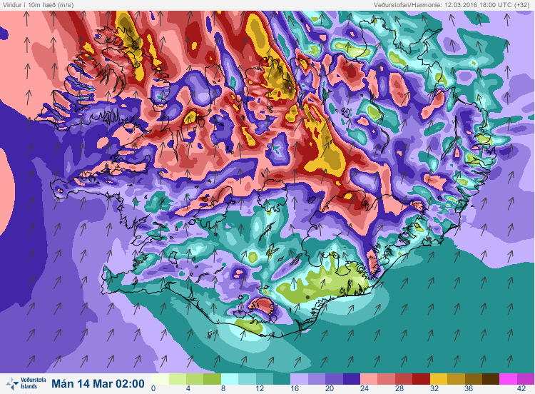
Tomorrow (Sunday 13-March-2016) extremely bad weather is expected on south to north Iceland. The weather is also not going to be good in other parts of Iceland, but it is going to be far worse in south Iceland, western Iceland and north-western Iceland. With wind reaching 32m/s (115km/h) and with far stronger wind gusts. Today the weather has also not been good, but tomorrow it is going to be worse. Roads are going to get closed, as did happen today (12-March-2016). If you are in Iceland follow the closures since in this type of weather a rescue mission might not be possible due the the weather. The rescue crews might not even attempt reaching stuck people if it comes down to it. Since this strong wind is going to be followed by a warm weather and heavy snow melt at the same time, there is a risk of local floods in the next 24 hours.

160312_1800_032
Its going to be bad weather tomorrow. Follow the advice given in this weather. Copyright of this image belongs to Iceland Met Office.

This is only the weather forecast today. Tomorrow might get a lot worse if the weather forecast is off, that often happens in Iceland due to random factors of nature.

Still mostly quiet in Iceland

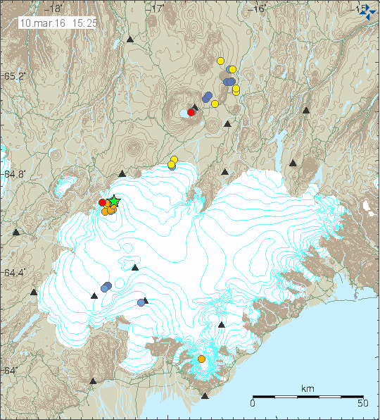
Today (10-March-2016) an magnitude 3,2 earthquake took place in Bárðarbunga volcano. The location of the earthquake swarm was in the caldera, with the location of the 3,2 magnitude earthquake being in the North-east part of the caldera.

160310_1525
The earthquake activity in Bárðarbunga volcano today. Copyright of this image belongs to Iceland Met Office.

The depth of this earthquake swarm was shallowest at 0,1 km, but most depth was 8,6 km. No other change has been observed in Bárðarbunga volcano so far. Other than this minor activity today in Bárðarbunga volcano activity remains low in Iceland. Currently there are storms passing over Iceland, that reduces the sensitivity of the SIL network.

Donations

Please remember to support my work with donations. I’m getting rather broke at this moment. This will get better with time. That I’m sure of. But that moment I’m in minor problems and any help is welcomed. Thanks for the support. 🙂

Quiet in Iceland at the moment

For the past few days it has been quiet in Iceland when it comes to earthquakes and volcano activity. Quiet period happens, they are usually followed by a spike in activity somewhere in Iceland.

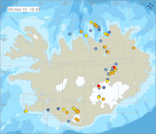
160309_1940
All quiet in Iceland at the moment. Copyright of this image belongs to Icelandic Met Office.

For those wanting to pass the time while it is quiet. I suggest a message in a bottle website that Rúv put on, as part of a science show for kids they had on the schedule this winter. It’s updated several times a day when the bottles send a message to a passing satellite.

Message in a bottle (Rúv.is)

Possible confirmation of minor eruption in Hamarinn volcano in July 2011

In July-2011 a minor eruption took place in Hamarinn volcano (part of Bárðarbunga volcano system). For a long time I’ve thought that those events in Hamarinn volcano where an eruption, rather than anything else. Due to how the glacier flood appeared and how sudden this all thing did happen.

Today (05-March-2016) Stöð 2 (Channel 2) ran a small news segment about this and the possible confirmation of this minor eruption in Hamarinn volcano in July-2011. I have the same view on the minor eruption in Katla volcano that same month. Its the view of Magnús Tumi, professor in geology that the events in Katla volcano where due to hydrothermal activity, not a minor eruption. I disagree with his assessment on what did happen in Katla volcano that summer. The top flood from Hamarinn volcano in July-2011 was 2.200m³/sec.

The articles I wrote about the events in Hamarinn volcano can be found here.
New harmonic tremor detected. But it is not from Katla volcano
Glacier flood confirmed from Vatnajökull glacier, flood is from Hamarinn volcano (Loki-Fögrufjöll area)

Vísir.is / Stöð 2 news in Icelandic

Lítið leynigos líklega í Vatnajökli árið 2011 (Vísir.is, Icelandic, images, video)

Earthquake swarm far north of Kolbeinsey Island

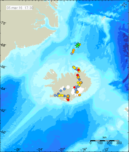
Today (5-March-2016) an earthquake swarm place took place around 190 km north of Kolbeinsey Island. Two largest earthquakes detected had the magnitude of 3,3. Other earthquakes where smaller in magnitude. Due to distance exact location is difficult to confirm, along with exact magnitude. This earthquake activity did not appear on EMSC seismic network.

160305_1730
Green stars show the location of this activity. Its only a best estimate by Icelandic Met Office. Copyright of this image belongs to Icelandic Met Office.

At this location there might be a volcano, it is unconfirmed at the moment. Last eruption is suspected to have taken place between 1997 or 1998. This volcano doesn’t have any name that I know of.

Four minor eruptions took place in Bárðarbunga volcano in August-2014

In Stöð 2 (Channel 2) news this evening was a short news segment about four minor eruptions that took place in the time between the dyke intrusion starting (16-August-2014) in Bárðarbunga volcano and until the eruption in Holuhraun (second link here) started (29-August-2014). The second small Holuhraun eruption, that lasted only for few hours (link 1 here [images, 2014], second link here [images, 2014]).

Those eruptions where small, didn’t break the glacier surface, but they did create small cauldrons. Three of those eruptions took place above the dyke on its path to Holuhraun eruption site. One of the eruption took place in side of Bárðarbunga volcano, south of the caldera (red circles on the map in the news). The mystery of what happened to all the melt-water has been mostly solved. Following this eruptions a rift episode took place (ongoing) and that formed cracks in the surface, allowing the water to go underground and not flowing into the nearby glacier rivers.

Magnús Tumi, the geologist spoken with at Earth Science at University of Iceland doesn’t think Bárðarbunga volcano is preparing for a new eruption. I disagree with his assessment. I base my assessment on earlier documented history, far as that goes and also the fact that rifting is currently taking place in this area and such events never do things quietly, even if no eruption happens, earthquakes do (and a lot of them).

Vísir / Stöð 2 news segment in Icelandic

Fjögur önnur eldgos urðu í Vatnajökli frá Bárðarbungu (Visir.is, Icelandic, video, images)

Article updated at 00:50 UTC on 04-March-2016. Error fixes.
Article updated at 21:16 UTC on 05-March-2016. Error fixes.