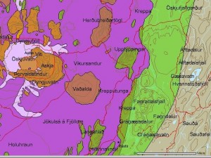
Upptyppingar are a tuff mountains in the east highlands in Iceland. There formation is contributed to a sub-glacier eruption in this area around 12.000 years ago. A second older sub-glacier eruption feature is also present in this area, it is called Álftadalsdyngja. It is believed that it did form around 700.000 years ago in a basalt eruption in this area. Upptyppingar and Álftadalsdyngja are both inside Kverkfjöll volcano fissure swarm.

Map of the area. Copyright of this picture belongs to how created it. Author unknown. Picture is from here.
In the year 2007 (Week 50) a earthquake swarms started to appear in Upptyppingar area. Earthquake activity in Upptyppingar area have continued since then. With total number of earthquakes in this area since the year 2007 is something over 6000 total. The reason why earthquakes are happening in this location is because magma is pushing up trough the crust in this area. This has been confirmed by GPS measurements since the year 2007.
It is my opinion that increased activity in Askja volcano might trigger a eruption in Upptyppingar area or in nearby area. As the risk of dike intrusion from Askja volcano into the Upptyppingar magma sill might trigger a large fissure type of event in this area. This is just speculation based on observed data. So please take note of that fact. The reason why I fear dike intrusion from Askja volcano is due to the changes that Upptyppingar magma has created in the nearby crust. But if this happens depends on how Askja volcano eruptions are going to behave in the future.
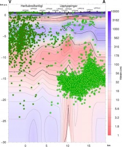
Here are some scientific data on Upptyppingar and the magma that has been collecting at 15 km depth below Upptyppingar mountains since the year 2007.
EARTHQUAKE SWARMS AT UPPTYPPINGAR, NORTH-EAST ICELAND: A SIGN OF MAGMA INTRUSION? (pdf, study)

Location of the earthquakes since the year 2007. Copyright of this picture belongs to Icelandic Met Office. Picture is from here.

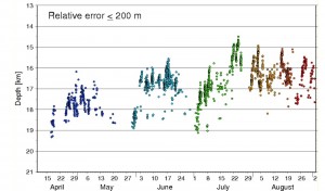
Depth of the earthquakes in the year 2007. As can be seen, the magma moved upwards with time. Copyright of this picture belongs to how created it. Author unknown. Picture is from here.

Estimated location of the magma below Upptyppingar mountain. This location is based on earthquakes and other measurements. Copyright of this picture belongs to how created it. Author unknown. Picture is from here.
What happens with Upptyppingar is now just a question of waiting and seeing. But there is also a good chance that this magma is never going to reach the surface in a eruption and is just going to cool down there and form a basalt dike that is going to be exposed in few million years when the weather and ice remove the rocks on top of it.
