New SIL seismometers around Eyjafjallajökull volcano and Mýrdalsjökull (Katla)

The seismometers that British Geological Survey did pay for to be installed around Eyjafjallajökull volcano and Mýrdalsjökull (Katla volcano) have been integrated into the Icelandic Met Office SIL Seismometer Network. They have at least been marked into the Icelandic Met Office earthquake web page.
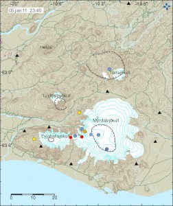

Image is from Icelandic Met Office. Copyright of this picture belongs to them.

The new stations are marked with a triangles on the map. The older SIL stations can be found at Icelandic Met Office tremor web page. Currently the new SIL stations are not on Icelandic Met Office Tremor web page yet.

What this means for earthquake recording in this area is that Icelandic Met Office is now able to detect smaller earthquakes. Location of earthquakes is also going to improve a great deal, so automatic location of earthquakes is going to improve a great deal in this area. This means that more earthquakes are going to be visible on Icelandic Met Office maps then before.

A new deep earthquake in Esjufjöll volcano

A new deep earthquake did just happen earlier tonight. The SIL system at IMO did give the earthquake the size ML1.7 with the depth of 22,5 km. In my experience this normally means that a earthquake swarm is about to start in Esjufjöll volcano. But this is not always the case, so we just have to wait and see what happens. But since earthquakes did start in Esjufjöll volcano last autumn (2010) with a earthquake swarm of about 70 earthquakes.

The activity has continues since then. But the earthquakes have completely stopped in-between earthquake swarms. This behaviour appears to be not uncommon in volcanoes in Iceland and elsewhere around the world. The earthquake yesterday in Esjufjöll volcano was size ML1.9 with the depth of 5.4 km. It is clear that a magma is creating this earthquakes, but there are few tectonics earthquakes in this area (but they do happen).