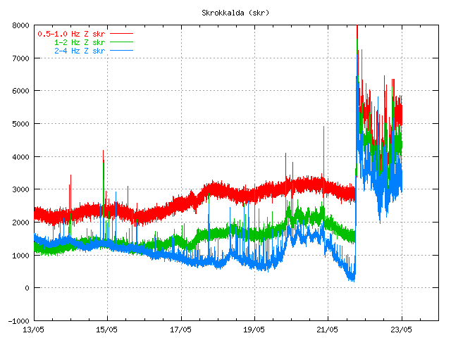
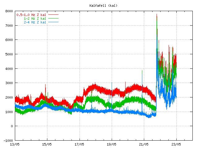
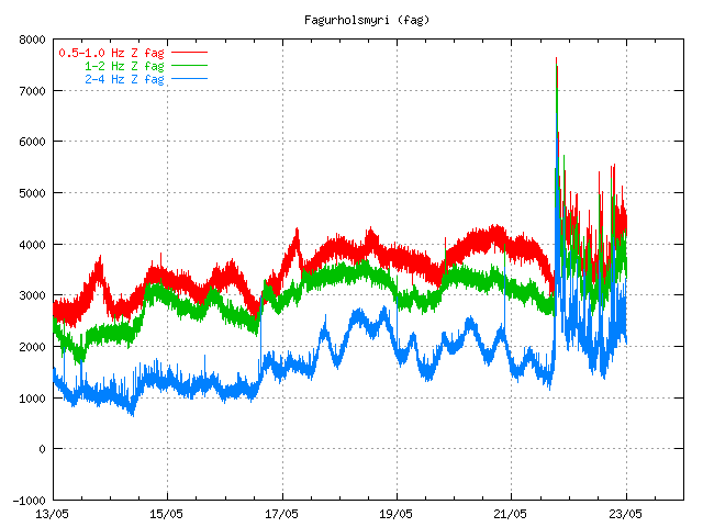
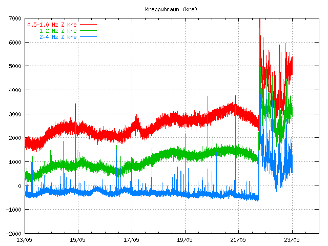
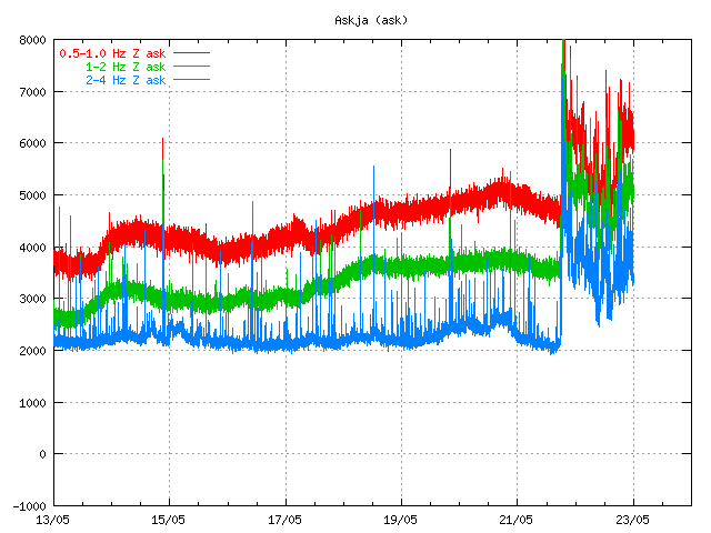
Here are few harmonic tremor charts from the Grímsfjall volcano / Grímsvatn eruption. It can clearly be seen where the eruption looses strength for an few hours. It is also clear when the eruption starts to regain it’s eruption strength again.
The volcanic tremor is best seen on 0.5 – 1Hz band, alongside 1 – 5Hz bands.
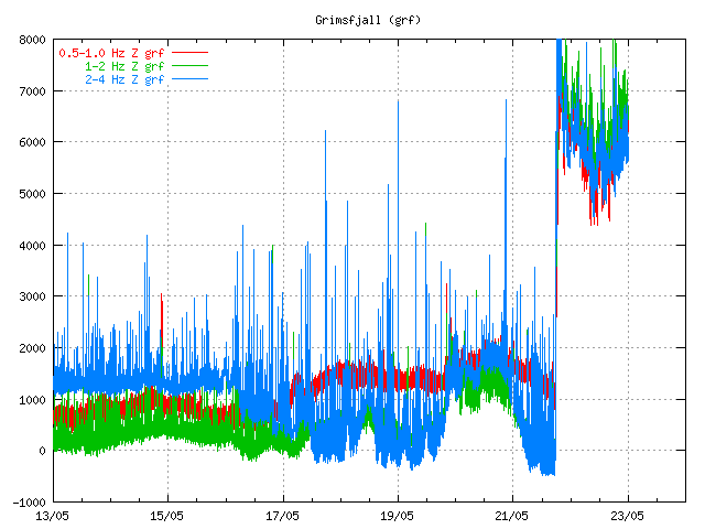
Grímsfjall volcano / Grímsvötn SIL station.
All pictures are from Icelandic Met Office web page. Copyright of this pictures belongs to them.

And a plot of the May quakes on the grav anomaly chart.
http://i56.tinypic.com/11b5jyp.png
I saw this question fly by earlier… dunno if it helps.
I am not 100% certain of where in the caldera the eruption occurred, but we (the denizens of this blog) had noted activity under the southern caldera. There was a line of quakes the progressed somewhat E-W, deeper under the western side. This is a depth v time plot of a box around that position.
One year + 4.5 months
http://i51.tinypic.com/jzcec1.png
And that same box but only looking from the 18th until now.
http://i55.tinypic.com/28gwff9.png
I can’t understand why the same tremor pattern is present in all Icelandic stations. As if the whole crust is mirroring Grímsvötn’s harmonic tremors.
Just for fun… how I have my control room set up:
http://www.facebook.com/photo.php?pid=32272847&l=87d5e53025&id=1528659644
Mike
Oh, not again. 😀
I reccommend Firefox + Tile Tabs extension for a similar arrangement with just one browser window.
http://www.youtube.com/watch?v=XO6agXxrsnI
And you thought dolphins and land volcanoes were unrelated!
That’s so nice! I didn’t know delphins lived that far out north….
They sure are fast swimmers! 🙂
Hey folks,
just wanna say thx for this awesome blog and contributors.Never stop
Much respect&love
New quakes under Vatnajökull and even on Myrdalsjökull there has been a few new ones.
At the Gjalp site there was even one m3.1. It all seems to be split in two locations. Will be interesting to see where this is headed!
Hmm..They dissapeared. Is the IMO site updating ok? Seems that there are a few new EQ´s but they are not registering ok.
I’m curious about the earthquakes that accompany a volcanic eruption. Can you feel them? Are they big? If so, how frequently?
They can be big.. but most of the times they relatively small (smaller then earthquakes caused by tectonic plate movement). Correct me if I am wrong since I am not an expert!
If you can feel them depends on the magnitude of the earthquake and the distance you are away from the earthquake (depth). I believe that from a magnitude 3 there is a good chance that you feel it when you are close to it. ==> http://en.wikipedia.org/wiki/Richter_magnitude_scale
Thanks. I’m from Christchurch and we’ve just had a couple of devastating earthquakes, which is why I’m curious. Have you had any over magnitude 5?
From what I know the volcanic earthquakes that accompanied the Pinatubo eruption in 1991 was preeced by earthquakes as strong as 6 on the mercalli scale, which usually can be translated to M5-6 richter scale.
The strenght of volcanic earthquakes usually depends more on how ductile the crust is, rather than the strenght of the eruption (which ofcourse also plays a major role).
Z displacement here shows a sharp drop:
http://hraun.vedur.is/ja/vatnajokulsvoktun/gps_faersla.html
Logic I think, since the volcano is letting of pressure and magma, results in deflation of the magma reservoir and a downward movement of the crust
Not sure, because the sideways movement is still increasing, so it could just be that the magma is moving sideways perhaps. In theory it should drop, but I am not sure it has done it really yet. It looks more like it is just moving. What do you experts think?
The GPS signal is travelling trough the ash cloud. So it might not be the most accurate measuring at the moment.
The ash cloud definitely affects the GPS signal.
Seems that http://en.vedur.is/earthquakes-and-volcanism/earthquakes/ has stopped updating all together. A complete lack of EQ´s seems highly unlikely.
There should not be any earthquakes as the magma has clear path to the surface at the moment.
Earthquakes are also being lost in the harmonic tremor from the eruption.
I am having trouble with the mila webcams. I can only get the one of the Lake. The rest just show a black screen with a play button and when I push it it just reappears. Do you know if there is a general technical issue may it just be my computer. It is so frustrating because I spend the whole year following the Icelandic tremor measurements and when a volcano finally happens I can´t see it. Thanks Lori ps I really like your blog.
There is a chance that the camera is in a middle of a ash cloud. In that case only thing you are going to see is a black screen. It does not matter if it daylight or not.
It just shows a black square with the White play button it the center, there is no image. I have been able to access one of them once this morning and it was all brown ash everywhere with no visibility but now I can´t even get in to see the brown ash. jajajja When I push the play button this little white circle goes around the play simbol and then stops and nothing. Yesterday I had the same problem. I wonder why.
I guess that the camera is not yet up and running.
Situation in South Iceland is much better! There was a thick volcanic fog during the night and deposited significant ash. Now, the sky continues overcast but from a big mass of clouds that have entered from the east. Surface wind blows from the north.
It looks like most ash will first travel SW of Reykjanes by northeast wind in Iceland and then drift back eastwards to the UK by Thursday.
I found this suspect production on yourtube claiming that Bardarbunga and Grimsvotn were waking up. To me it looks like Grimsvotn and Gjalp – with Gjalp perhaps being sub-glacial again, but I an English so would like confirmation please.
See http://www.youtube.com/watch?v=yyDnWfd5saQ
Bárðarbunga volcano is quiet. Until that changes it is going to remain like that.
Are you able to see with these?:
http://live.mila.is/grimsvotn/
http://live.mila.is/grimsvotn2/
If so then it must be my computer or my conection from Spain or something. hmmm
When you see the “Jökulsárlón” cam image is all right. The black box with arrow indicates that this cam at the moment not online
Ok Thanks, I appreciate your help. I’ll just have to wait then.
No, not from here in the UK anyway.
There was just an volcanic earthquake recorded in Grímsfjall SIL station. This earthquakes does not appear on the automatic list. I did just see it on the tremor plot.
There is also news about that geologist are hoping for the water in the crater to run out. When that happens we get lava eruption and little to no volcano ash.
http://www.ruv.is/frett/bida-thess-ad-vatn-i-gignum-klarist
How do you see that on the tremor plot? Do you use this: http://hraun.vedur.is/ja/oroi/grf.gif or do you have another link?
It did stand out from the explosions that the SIL station(s) is recording. It had a lower frequency then explosions. But it is hard to see them, this one was a strong one (how big it was, I have no idea).
I did use Grímsfjall SIL station and others around Grímsfjall.
How do you “use” SIL stations?
Can we too?
I just look at the tremor plots that are online. I am used to look at them a lot so I know how to spot a earthquake.
Anna Island on May 23, 2011, 7:13 AM
The ash-fall is still pretty heavy because there’s still a lot of water in the caldera apparently. In Icelandic:
http://www.ruv.is/frett/bida-thess-ad-vatn-i-gignum-klarist
Wouldnt this indicate that the activity at Grimsfjall is also stirring up some movement below Hamarinn?
Sunday
22.05.2011 21:49:43 64.487 -17.760 16.7 km 1.9 99.0 2.4 km E of Hamarinn
Just 2 km E of Hamarinn and almost 17km deep. Mag 1.9.
And this one aswell…
Sunday
22.05.2011 10:05:00 64.474 -17.757 16.1 km 1.2 99.0 2.9 km ESE of Hamarinn
Looking at http://hraun.vedur.is/ja/vatnajokulsvoktun/gps_grimsfjall.html the scale is so messed up now but it looks like the GPS sensor has gone down a long way and also moved a fair distance northwest!
Based on the pattern of black ‘numbers’ on it it would have appeared to have moved around 20cm north and west and around 18cm down
That’s really a lot, but as Jon said the GPS signal has to travel through the ash cloud which messes up te signal
The GPS signal is travelling trough a massive amount of ash cloud. It is not reliable at all at this moment. This was a lesson learned after the Eyjafjallajökull volcano eruption.
We just have to wait and see what the GPS data tells us when this is over.
Or the GPS station has been broken. I guess that is a common fate for ones near eruptions.
Have they done a proper thermal scan of the eruption to pinpoint if there’s multiple vents or the potential of a fissure?
This recent summary of seismicity under Vatnajokull since 1990 is fascinating:
http://en.vedur.is/media/jar/KSV_eq_locations.pdf
Page2 shows EQ rate rising rapidly since 2005.
EQ depth data reveal very few at depth – and moho here is about 35-40km down.
Does that indicate that the magma inducing the shallow EQS is already in place and does not need to rise from depth??
Pictures of the ash fall in Kirkjubæjarklaustur town.
http://www.visir.is/apps/pbcs.dll/gallery?Site=XZ&Date=20110523&Category=FRETTIR&ArtNo=523009997&Ref=PH
Monday
23.05.2011 09:06:38 64.500 -17.461 5.2 km 2.0 99.0 13.9 km NW of Grímsfjall
It is a bad thing if volcano earthquakes are happening in Hamarinn volcano. That volcano is has a lot more ice coverage then Grímsvötn volcano. As the top of Grímsvötn only has thin glacier coverage.
But so far Hamarinn volcano shows no signs of imminent eruption.
The earthquakes that has been taking place in Hamarinn volcano I guess they are volcanic right? What caught my eye was that they were quite deep and not far from eachother.
Even if an eruption does not happen now or this year it surely can not be far away. A few years max perhaps?
The earthquakes are most likely from magma. At least I did see one earthquake of that type in the SIL data from Icelandic Met Office (in the tremor plot).
But this activity started after the eruption in Grímsvötn. So it is hard to know what that means.
I think the ones you refer to are Gjalp. I thought they were Harmarinn but others on the forum who live in Iceland have corrected me.
We can only wait and see…
@ treacleminer. No I meant the ones within 2-3 km from hamarinn at 16-17km depth. If you look at the map there are a few close to Hamarinn.
http://en.vedur.is/earthquakes-and-volcanism/earthquakes/vatnajokull/
Sunday
22.05.2011 21:49:43 64.487 -17.760 16.7 km 1.9 99.0 2.4 km E of Hamarinn
Sunday
22.05.2011 10:05:00 64.474 -17.757 16.1 km 1.2 99.0 2.9 km ESE of Hamarinn
Has the English part of the http://www.vedur.is/ website gone down for anyone else?
F9 pressed a number of times. The Icelandic part is working ok, just checking?
It works normally for me.
Officials at the European Union now say that the the ash could enter British and Irish airspace today or tomorrow while the Irish Aviation Authority (IAA) said there was a “possibility” of disruption to air travel tomorrow.
That would be interesting as it would get Obama, who is visiting Ireland today and tomorrow, before continuing to London, stuck!
I don’t care too much about teh airspace, but I feel so sorry for all those poor farm animals where the ash is falling in Iceland. Will they be brought in?
I have trouble locating Hamarinn. It cant be the same as Bárðarbunga?
Hamarinn : Left above the Grimsfjall (this card refreshed themselves, but only the Icelandic)
http://hraun.vedur.is/ja/skjalftar/vatnajokull.html
Thank you very much. I have tried google and other maps, and on the wikipedia article on volcanoes in Iceland it does not appear. Does it go by another name also?
Look on this map: http://en.ja.is/kort/#x=555531&y=442318&z=6&services=18,16
Haraminn/Loki-Fögrufjöll/Lokahryggur (sp?) is part of the Bárðarbunga system. It is SW of Bárðarbunga and E of Grímsvötn and covered by Vatnajökull. I’ve put an icon for it on my map (click on my name).
I the spirit of Jon’s post, I am curious to know why the tremor is detected so widely.
This is a useful review article on volcanic tremor:
http://epic.awi.de/Publications/Kon2003a.pdf
– it is heavy going for the non-physicist, but we can see how many different mechanisms can crate tremor.
But still dont have an answer as to why tremor is detected over such a wide area…
Peter: I have been myself asking about that all the time. It is as if the whole Iceland is behaving like a single huge volcano.
by 7 AM tomorrow ash cloud will completely cover Scottish airspace, enter English airspace
Guys, the tremor all around Iceland stations is perfectly normal and happens when there is a strong volcanic eruption, much as earthquakes stations detect powerful earthquakes in other parts of the globe, such as in Japan or Indonesia quakes.
I think now the things to look is to both the disruption of the airspace over the UK late this week, how big and when the Vatnajokull flood will be, and also if whether this eruption triggers something at Hamarinn.
But we did not see such widespread tremor around Eyjafyatlajokull ‘s eruption.
Is it not interesting that no plume is detected on radar at present,yet the tremor is not much reduced since the eruption began. So is the ongoing tremor reflecting a deeper source that does not reflect near-surface activity? and is this the reason why tremor is detected over a wide area?
I think it’s less whater in volcano caldera…
Peter:
I sahere the same questions. Keep them coming! 🙂
I think Harmarin only does very small eruptions anyway. You probably would not notice it with Grimsvotn going up. Worse would be if a conduit has formed between Bardarbunga and Grimsvotn, because that would make Grimsvotn into a very different voklcano than previous experience of it. On the other hand Grimsvotn has done some big eruptions in the past.
If there is a conduit, that would probably give a high amount of tremors I guess… which we currently see.. but okay there could also be a 100 other reasons why the tremor is high (and rising at the moment)
Sander
Ash plume is visible again on the radar…
Sander
Link to the Radar image?
http://brunnur.vedur.is/radar/max_480.max_dBZ.html
Thanks. It looks like a denser small puff of ash appeared in the last 10 minutes as I’m writing. I wonder if it’s got something to do with the last small burst of tremor activity.
http://en.vedur.is/weather/aviation/radar/ is also possible
This is useful too, added to my “eruption monitoring brower window”:
http://i.imgur.com/Qs9VC.jpg
The tremor plots indicate to me an activity that has not significantly been dissipated by the eruption. The absence of radar-signal from a plume at present and the ongoing almost undiminuished tremor seems to me to eliminate the eruptive activity at the near surface as an important tremor source. The tremor may therefore have a deeper source. The tremor signals have the the same broad pattern over the past two days over a very wide area (about 75 to 100km radius) indicating they are reporting the same events. That could also be a sign of tremor at depth.
If we accept that tremor reflects processes associated with magma on the move then how deep could that be? Over the past 20 years the EQ activity in upper 20km under Vatnajokull has risen sharply. But below that depth very few EQs indeed.
[ http://en.vedur.is/media/jar/KSV_eq_locations.pdf ]
But the crustal boundary/moho is at 35-40km depth. Inflation has been ongoing over that time. So presumably magma been moving upwards from 40km deep without generating EQs? Perhaps now as aresult of the eruption it has accelerated, still without generating EQs, but now providing the tremor signal?
Wouldn’t we see quite a lot of inflation continuing rather quickly in that case? We seem to see movement rather than inflation. There may even be deflation, though it is unclear whether that is just horizontal movement of magma.
This may be a silly question – and if so i apologise. If inflation is always measured relative to reykjavic, and inflation was widespread (including under reykjavic) would we see it? Is inflation of reykjavic cross checked/ calibrated relative to a non-iceland point at all?
Maybe not on those published charts, but someone would soon notice it and cry panic. Everyone at home with their hiking GPS would wonder why their homes were getting higher and higher above sea level.
Some time in the geologically-speaking not too distant future, there will be another Laki/Eldgja-type eruption. If you look at it that way, it is perhaps not so suprising to see the activity between them at Grimsvötn/Gjalp, both in time and location if that makes sense.
What is the straight line of earthquakes to the west of Gjalp? Is it the glacier cracking due to meltwater running down the valley?
I wish the mila camera could get up and going
It’s up, and shaking.
Check Jon’s weather status; hell of a wind in Iceland by the looks of it.
Mike
There is a really good volcano map in the document:-
http://notendur.hi.is/~heidi/Data/Article-richard/GudmundssonHognadottir07.pdf
Excellnt – many thanks.
You can see the Loki-Torfajokull fissyre system I mentioned below.
An excerpt from that review:
“”A combined gravity and magnetic survey of Gr´ımsv¨otn (Gudmundsson and Milsom,
1997) revealed the existence of a 400 km3 intrusive complex in the upper crust underneath the volcano.””
Thats an awful lot of ash….
That’s equivalent to VEI >7!!!
@Henrik
Its interesting that the deepest EQ activity mentioned in that pdf was under the Tammrinn-Loki axis, with Gjalp at its western end. The Veidivotn fissure system extends SW from Bordabunga almost to Torvajokull.:
http://www.volcano.si.edu/world/volcano.cfm?vnum=1703-03=
That makes it closely parallel to Laki, Eldja . And its axis would not be far off the Tamarinn-Loki-Gjalp site of deeper EQ activity.
Peter
This is interesting:
(Gjalp: 0.6MW heat per sq metre! and joukulhaup flowing up-hill under ice.)
http://www.raunvis.hi.is/~mtg/pdf/2005SubglacVolcAct_MTG-DQS.pdf
AAggh, brain fade: “……….eastern end………”
This is the ash plume as seen close to Selfoss. Today it is almost hidden behind the clouds but looks very widespread into our direction (exactly as depicted in the radar). Earlier this morning, the plume was much more clear but I have not taken a picture of that.
http://img593.imageshack.us/img593/8903/pluma.jpg
Yesterday we saw a large cloud extending into our direction before we got a night of thich ash fog, but the plume was not very clear because it was hidden inside this ash cloud.
Before yesterday, in the first day, it was a beautiful view. A blue sky with the plume very defined cutting through the stratosphere with lots of lightnings. I haven’t took a picture, but this web picture shows what we have seen
http://farm3.static.flickr.com/2164/5745277872_b9c4b66336.jpg
I will go outside in an hour, to check whether we can see the plume more clearly again. To the north, in direction of Langjokull the sky is clear and I can see a thick grey ash cloud moving into that direction (as depicted in the radar)
Thanks for your posts and photos, trust your skies are clearing now that the wind is picking up. Keep safe.
Some of my pictures:
Ash deposited here north of Selfoss, during last night (200km away from Grimsvotn)
http://img807.imageshack.us/img807/4354/1000887.jpg
http://img862.imageshack.us/img862/8885/1000894.jpg
http://img32.imageshack.us/img32/8256/1000883f.jpg
When we went yesterday morning to Kirkjabaerklustur, into the pitch black ash cloud. Amazing black scenario! Photos taken at 11am, so during daytime!
http://img69.imageshack.us/img69/7785/1000706s.jpg
http://img855.imageshack.us/img855/2234/1000719.jpg
http://img715.imageshack.us/img715/937/1000697o.jpg
And as we drove back to the west, outside of the ash cloud, in Vík.
http://img846.imageshack.us/img846/7291/1000721.jpg
And this is yesterday at 6pm, again broad daytime, close to Selfoss. Look at how dark it became!
http://img69.imageshack.us/img69/6021/1000864u.jpg
Hope you enjoy this personal report!
First many, many thanks for the photos! But to horror pictures, I’ve never had enjoyment. They are terrible beautiful. Keep all to safety.
Jon
Congratulations on this blog, a fascinating read. In terms of scale how does this eruption compare with the 2010 event, are we still looking at a x10 event
Peter,
I too find those deep eqs intriguing, especially since they are about half-way down the crust and in those particular locations. Since the European and North American plates are moving apart, fissure eruptions such as Eldgja (934 AD), Veidivötn (1477) and (Laki 1783-4) are one way to “heal” the rift. But how is it accomodated around Vatnajökull? If anything, the divergence here is greater, so you’d expect some sort of volcano-geologic process to account for the rift reason tells us ought to be there. But what exactly is that process and why isn’t there rifting or evidence thereof in the Vatnajökull area, only to the WSW and NNE? Could it be that the crust is continually breaking at depth and those fissures are “healed” by magma, whereupon the crust breaks in a new location. Something akin to a solid-ish rock graben, if such a thing exists? 25 meters over a length of some 100 km and a depth of some 40 km in , say, a quarter of a century means some 0.4 cu km per year of magmatic filling would be neccessary to maintain crust integrity.
What would we occupy ourselves with if there weren’t these riddles to mull over!
Isn’t there a hypothesis of an underlying microplate under Bardarbunga? Couldn’t that explain tremors occurring at those depths (deep “subduction”?)
@henrik,
Well I should be in the workshop setting up a milling machine. Its the old science/engineering conundrum – which comes first?
Peter
has the eruption stopped? Im hearing lots of conflicting reports….
Plume development in the first few minutes (posted over in Eruptions):
http://www.pressan.is/Assets/Ingolfur_KPS_samsetning7.gif
Pika “What a Gem!”… Beautiful!
Yeah! 🙂
Is the camera shaking due to wind? Windspeed around 12-15 m/s according to IMO and that doesnt seem to be so much.
http://live.mila.is/grimsvotn2/
Or is Grim roaring high enough to make the ground tremble like that?
If this is trembling ground we should all start praying. 😉
Pictures of the start of the eruption in Grímsvötn.
http://www.pressan.is/Frettir/LesaFrett/magnadar-myndir-syna-fyrstu-minutur-gossins–i-grimsvotnum—svona-hofst-thetta-allt—myndir
So whats the status of the eruption. Would be cool if there were a dashboard type of graphic that would collate all the related data into a speedometer. Dream on dude.
Before when the eruption started, there were many posts about the ash cloud height and other indicators. Now, I don’t have a sense of what is occurring. Someone even mentioned the eruption had stopped. Is it still going on? Is there a link where we can get updates on the intensity or ash cloud height. Also, its really hard from the satellite links provided before to discern the difference between the actual ash cloud and the regular clouds. So, things are kinda foggy and don’t know where the get clarity.
Sorry, just rambling, but I will start clicking around.
Well the tremors over at IMO seems pretty high still which would indicate that it is still going strong.
http://hraun.vedur.is/ja/oroi/grf.gif
But at the same time if you look at the tremors below Grim seems to be winding down alot.
http://hraun.vedur.is/ja/vatnajokulsvoktun/grf_trem.gif
And the webcam doesnt really show a visible plume.
http://live.mila.is/grimsvotn2/
(There was visible sky over the clouds a few minutes ago).
Whatever it is I am almost certain that even if the eruption is winding down it wont last long given the violent eruption so far.
@Jón. I have no idea here and i might be asking a stupid question but can Grimsfjall build a lavadome? Is it even possible for a subglacial volcanoe to do that?
The Eumetsat RGB image is usefull for seeing the extent of the ash… it shows as the reds, so it’s clearly not punching through the cloud ceiling into the stratosphere above Grimsvotn recently, but you can see the extent of the ash moving towards the UK now.
http://oiswww.eumetsat.org/IPPS/html/MSG/RGB/ASH/ICELAND/index.htm
(Thanks to all the contributors here for the wealth of information 🙂 )
The GRF station GPS data shows big jumps now at http://hraun.vedur.is/ja/vatnajokulsvoktun/gps_grimsfjall.html but the direction of jump in X and Y is different to the eruption in 2004 (see e.g. here http://strokkur.raunvis.hi.is/~sigrun/GFUM.png ).
Sorry, those changes are to the same direction! I did not read the graphs correctly, and Sigrun uses a different scheme.
Assuming that this numbers that I found in the news are reviewed GPS data. The the GUFM GPS station has moved 40 meters to the north and about 20 cm down. I do not know how correct the news has this numbers. There also might be errors in the news (if the reporter got things wrong).
Other GPS stations nearby have not moved this much in the last 24 hours from what I gather. So that suggests that the data from GUFM might be wrong. But this should be be become clear in the next few days how much the deflation is taking place in Grímsfjall volcano.
The news also report that it seems that the magma is coming from great depth. That might mean a long eruption in Grímsfjall volcano.
The GUFM GPS station.
http://hraun.vedur.is/ja/gps/predorb/gfumpred.html
Jon
Did the news report say why they think the magma is coming from great depth?
Peter
Sadly no they did not. But they must have come idea on that. Maybe the ash cloud ?
They have samples of the ash right? Maybe they have identified the minerals in the magma already and that would indicate where it comes from..
They got a lot of samples of the ash. They can track day changes to the ash if they are lucky.
Peter:
I’ll just venture a guess: basalt is flowing, not the regular thracite -andesite we saw in Eyjafjallaökull.
That’s why the ash is coarser and possibly why it flows free of partial meltings.
Still I consider the nicroplate theory. Something similar to what happens in Etna. But I am no expert.
If the magma is indeed coming from a great depth would that be the cause of so many SIL stations showing the same pattern in tremors?
Daniel,
That would be my guess too!
Peter
That would also imply a longer eruption, although it may calm down for a while…?
The ash cloud is due to water getting into contact with the magma. When that stops a lava eruption starts with no to little ash cloud.
But then comes an effusive phase, and, with so much magma involved, the possibility of having many fissures erupting effusively at a time.
What is of much more concern to my layman eyes is the fact that harmonic tremors are being shared throughout the whole country. Scary just to imagine.
They are afraid of new fissures opening under the glacier. But that means large floods and new ash cloud.
Well if the magma is coming from a very deep reservoir it would mean that there is alot of magma which needs to come out. I wouldnt be surprised if this goes on for a while.