Orange alert level declared for Bárðarbunga volcano

This is short update on Bárðarbunga volcano. Due to ever changing nature of this events this information is going to get outdated quickly.

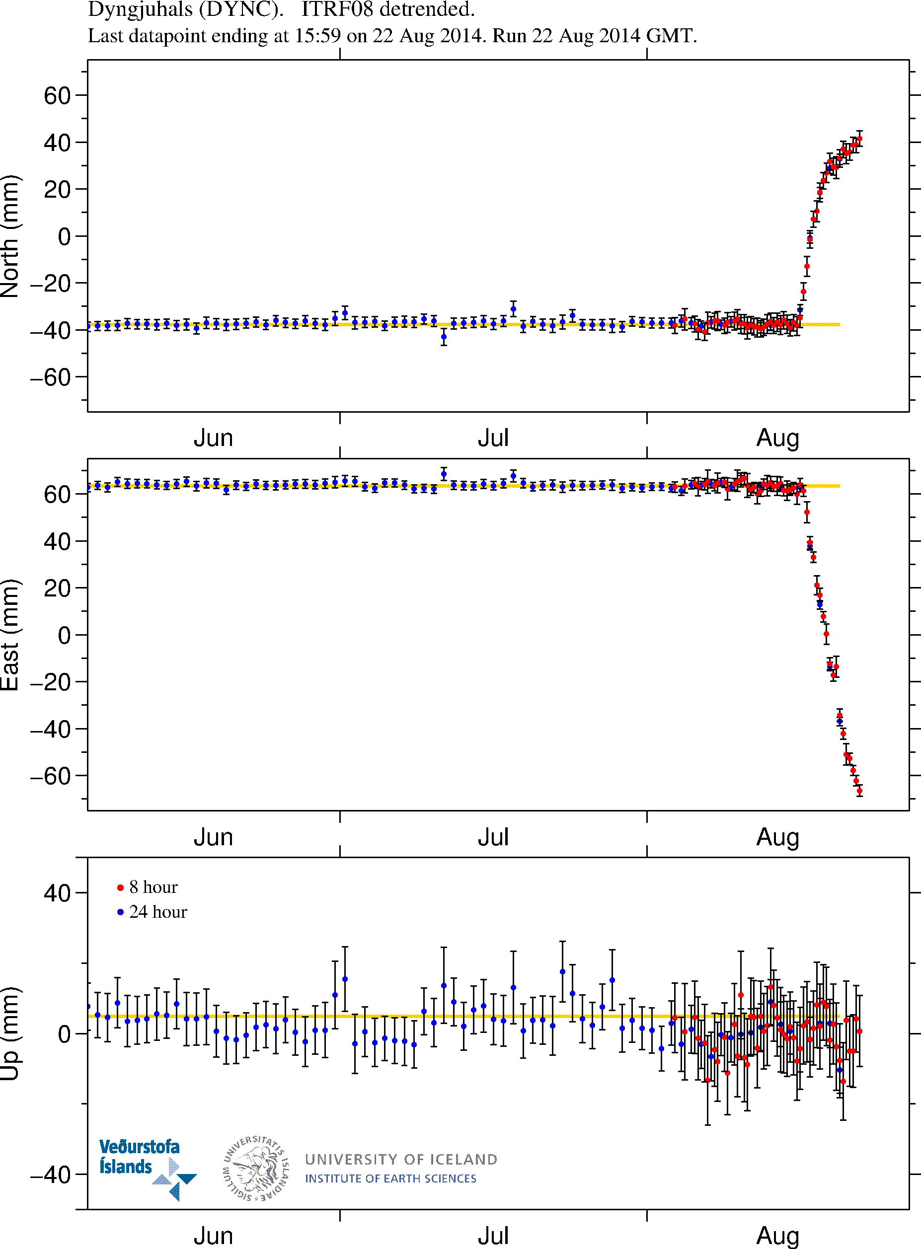
Icelandic Met Office has moved the warning level for air traffic up to Orange level (see here). GPS measurement have confirmed magma movements inside Bárðarbunga volcano and this movement is fast.

DYNC_rap.svd.18.08.2014.at.15.13.utc.raunvis.hi.is
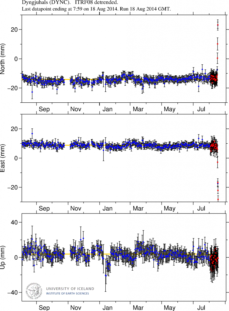
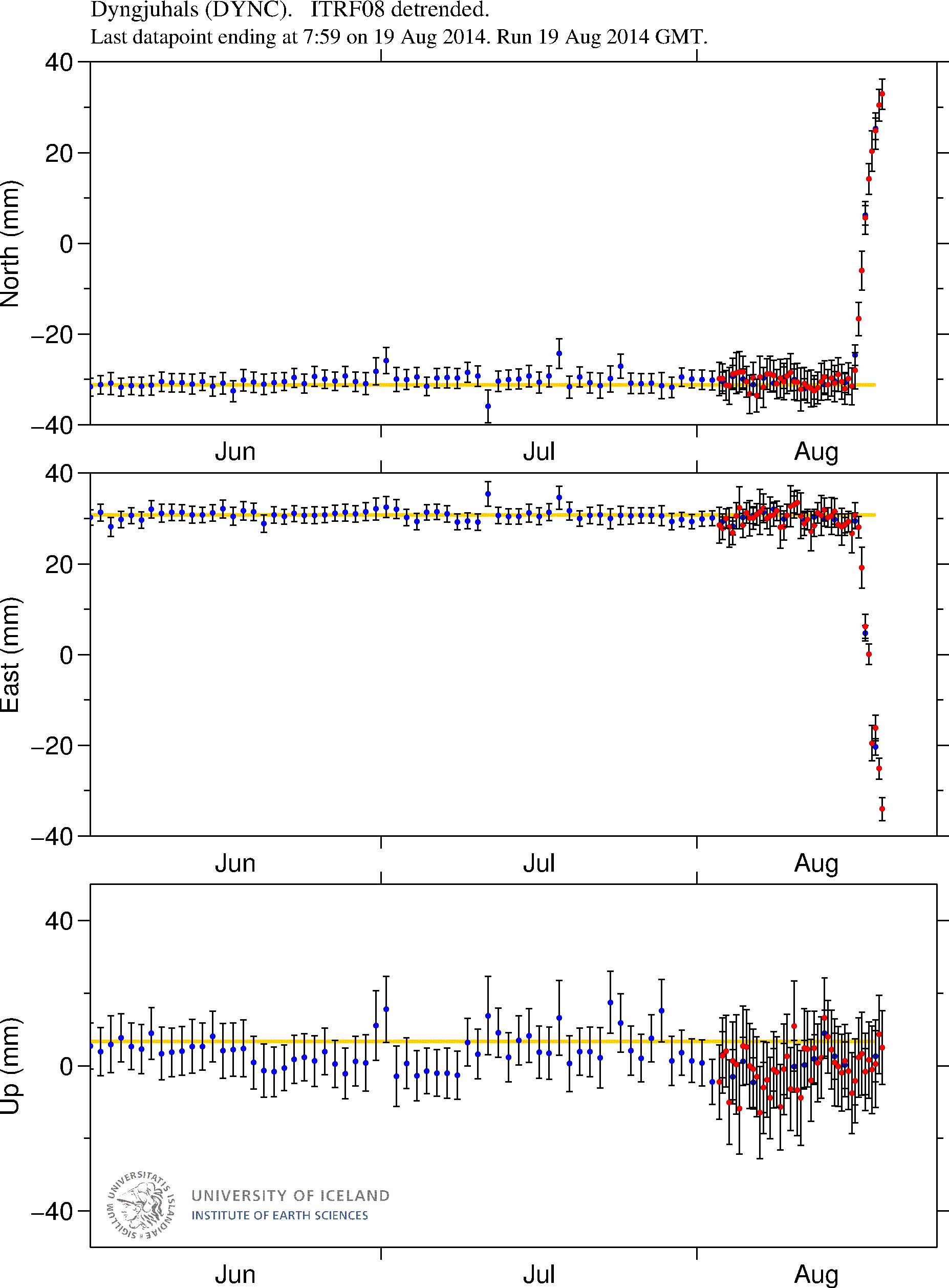
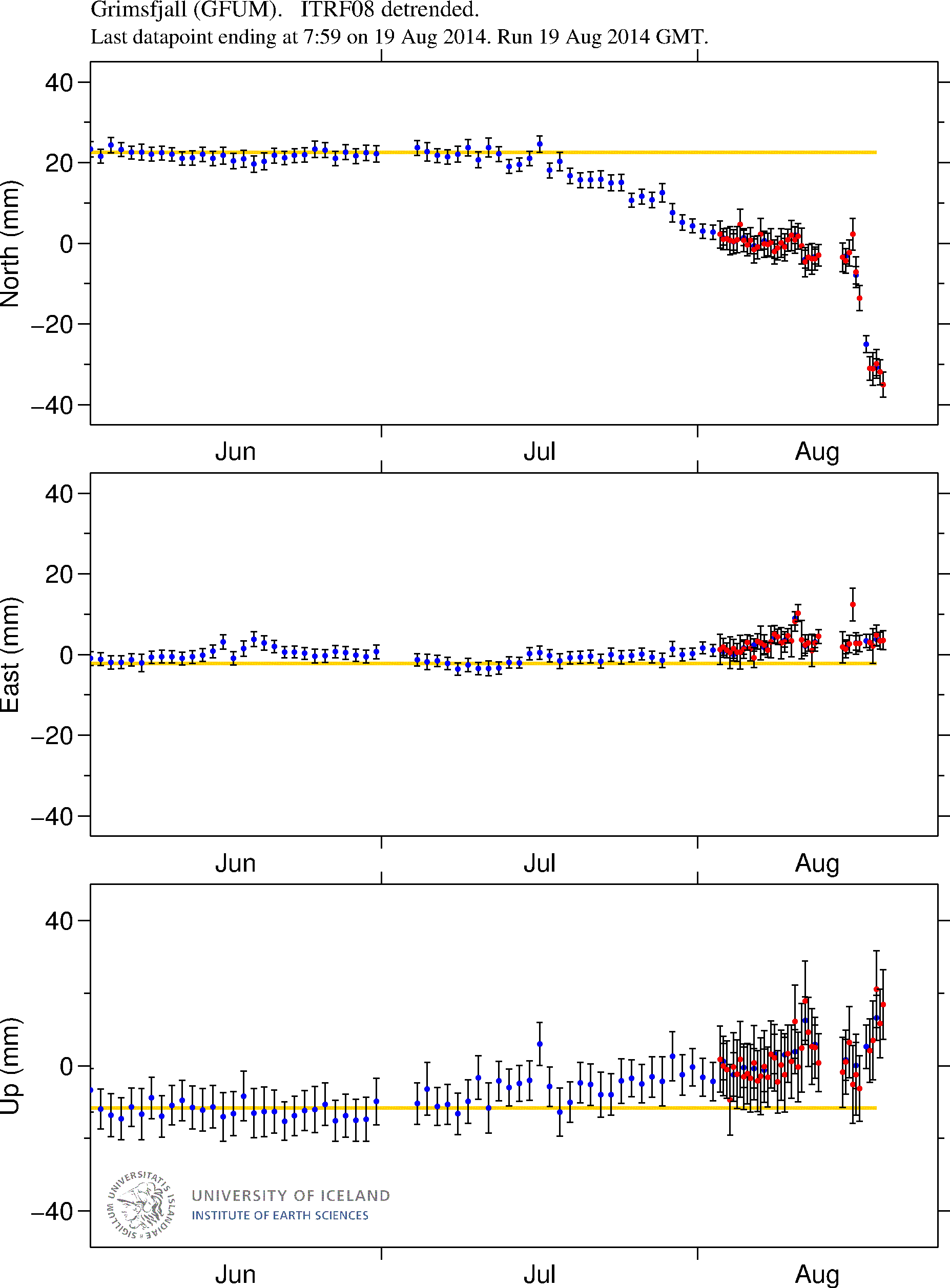
GPS data from University of Iceland. This data shows how fast the change has been in the past few days. More GPS data can be found here. Copyright of this image belongs to University of Iceland.

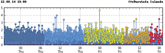
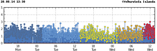
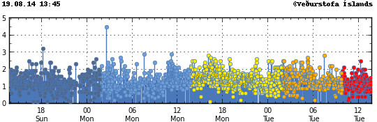
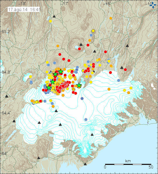
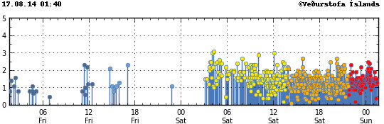
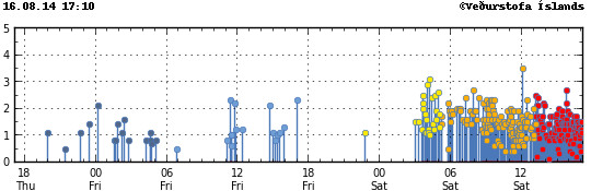
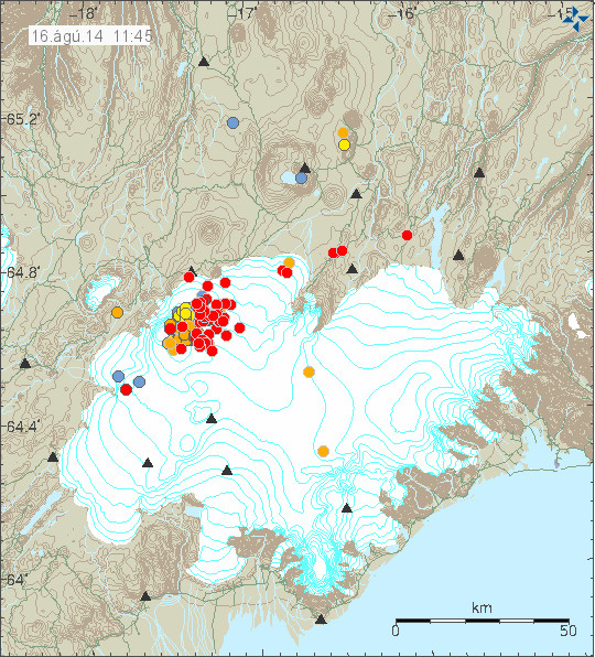
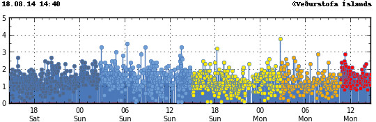
Earthquake activity has remained about the same, with regular fluctuation in activity. Overall however the activity has remained constant.

140818_1440
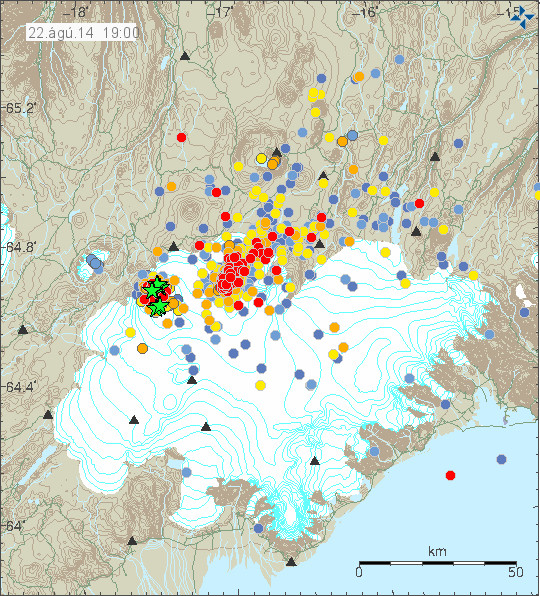
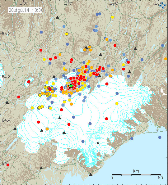
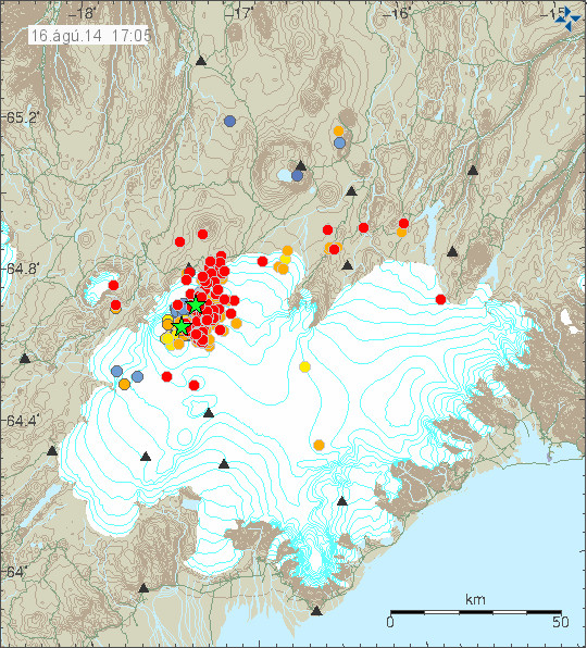
The earthquake activity in Bárðarbunga volcano. Copyright of this image belongs to Icelandic Met Office.

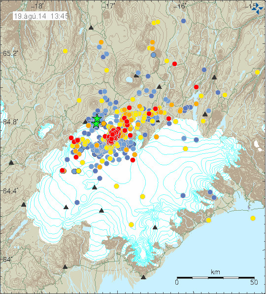
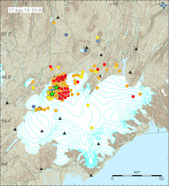
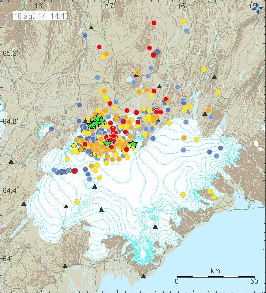
The earthquake activity in Bárðarbunga volcano has been migrating to the north-east over the past 10 to 18 hours. The activity close to Dyngjuháls appears to be stable at that location for the moment. Earthquake activity in other parts of Bárðarbunga have quieted down for the moment, that might change without warning.

140818_1440_trace
Earthquake activity has remained stable in Bárðarbunga volcano. Copyright of this image belongs to Icelandic Met Office.

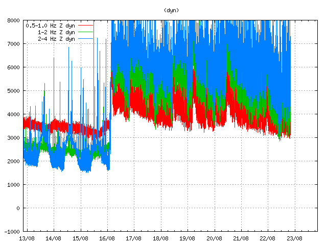
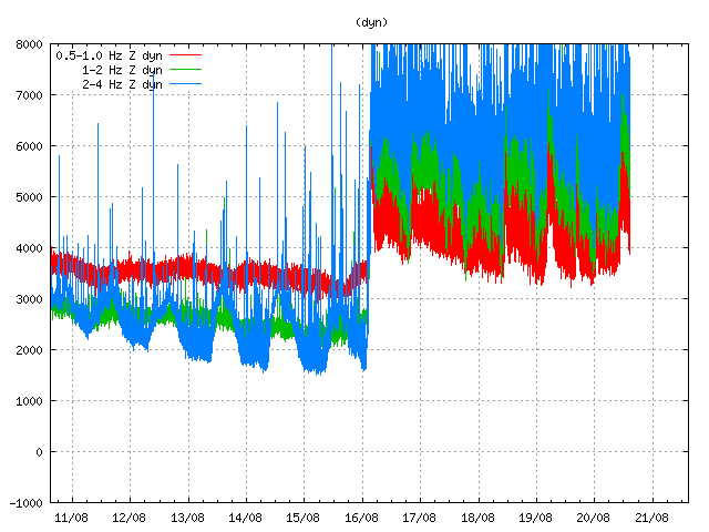
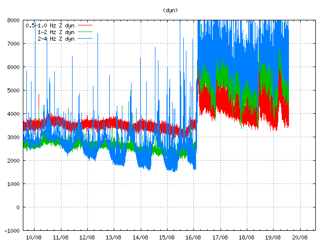
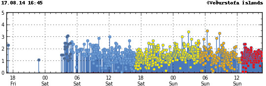
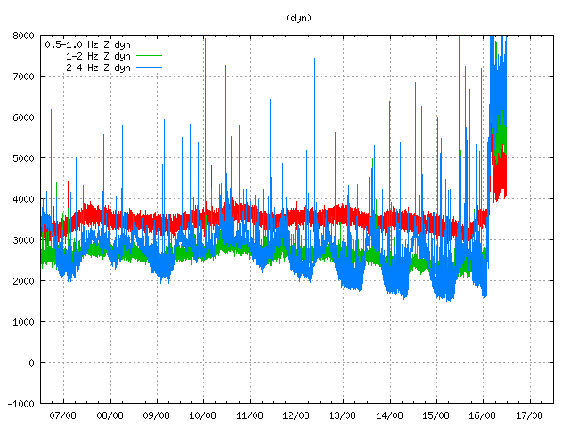
Harmonic tremor levels have remained stable since this started. They do drop a little in sync with the drop in earthquake activity.

dyn.svd.18.08.2014.at.14.46.utc
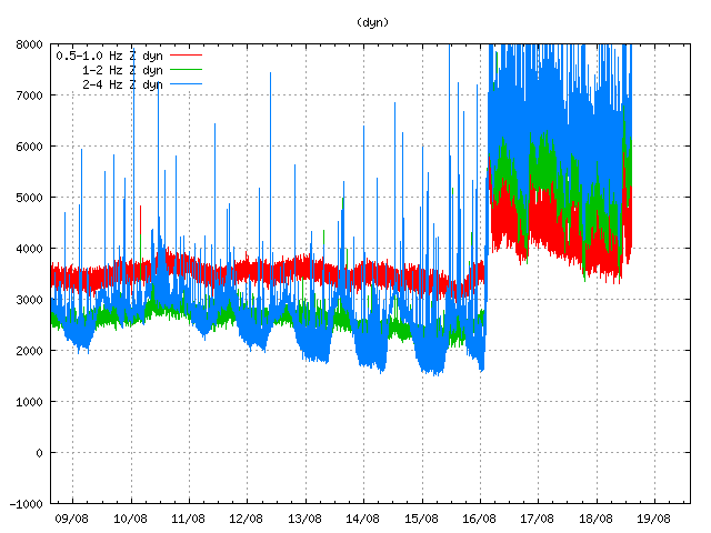
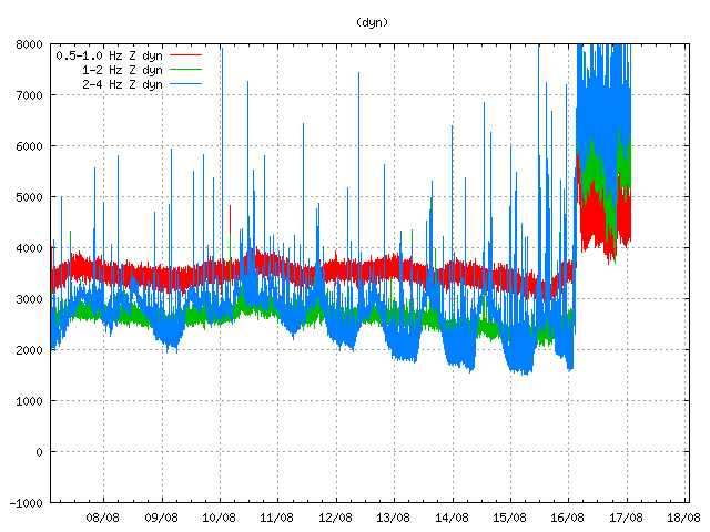
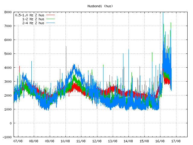
The harmonic tremor at Dyngjuháls SIL station. Copyright of this image belongs to Icelandic Met Office.

kre.svd.18.08.2014.at.14.47.utc
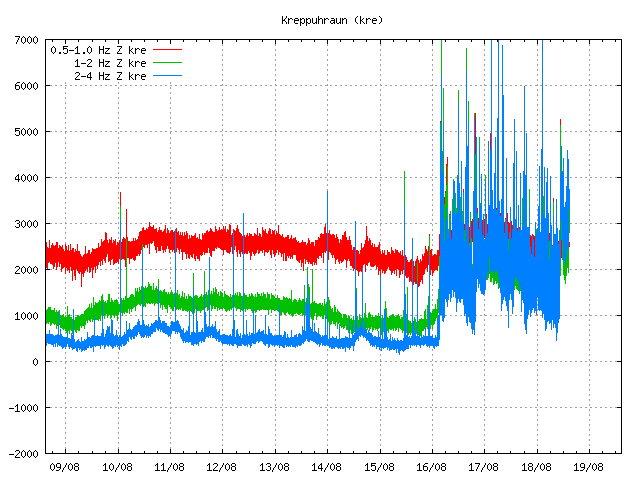
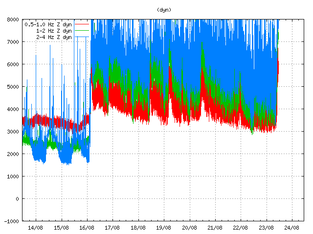
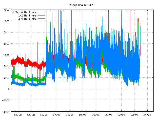
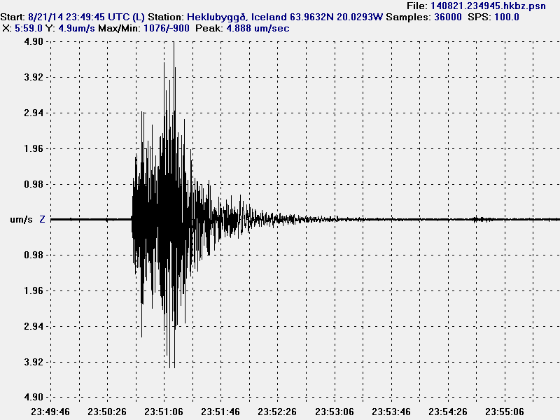
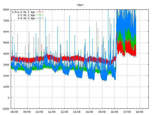
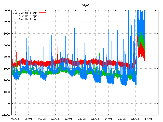
Kreppuhaun SIL station shows the harmonic tremor also. Along with interesting jump in the past hour of harmonic tremor activity. I am not sure why that is. Copyright of this image belongs to Icelandic Met Office.

von.svd.18.08.2014.at.14.46.utc
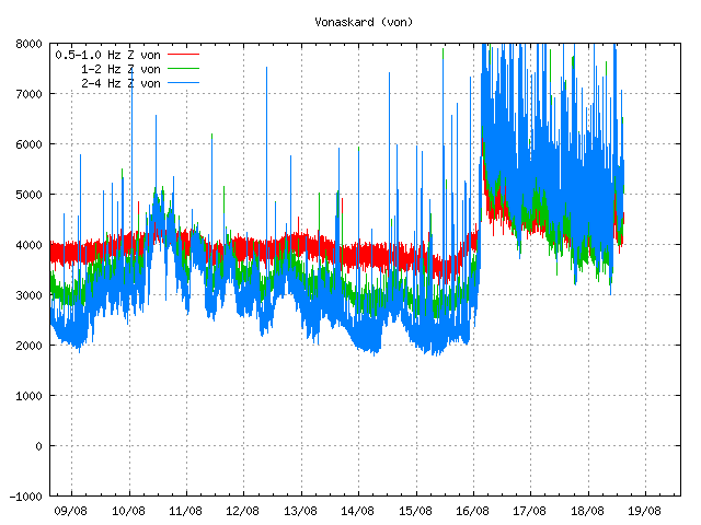
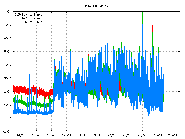
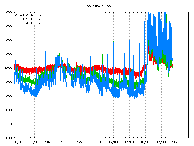
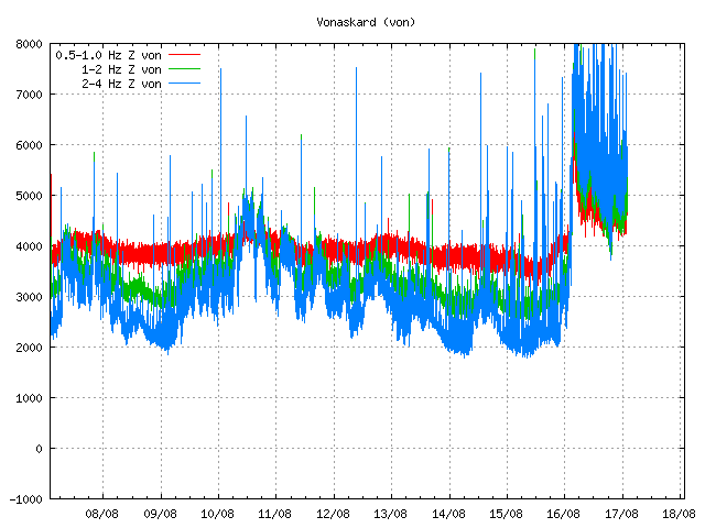
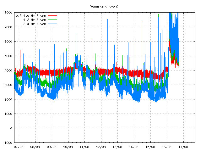
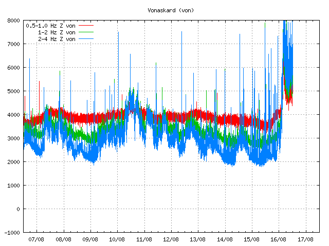
Vonaskarð SIL stations shows pattern that is close to what appears on Kreppuhraun SIL station. Copyright of this image belongs to Icelandic Met Office.

I am not sure why the harmonic tremor levels are what they are at the moment. Since no eruption has started. This might be due to changes in hydro-thermal areas under the glacier, or there might be some other reason for this that is not known to me.

IASK.svd.18.08.2014.at.14.46.utc
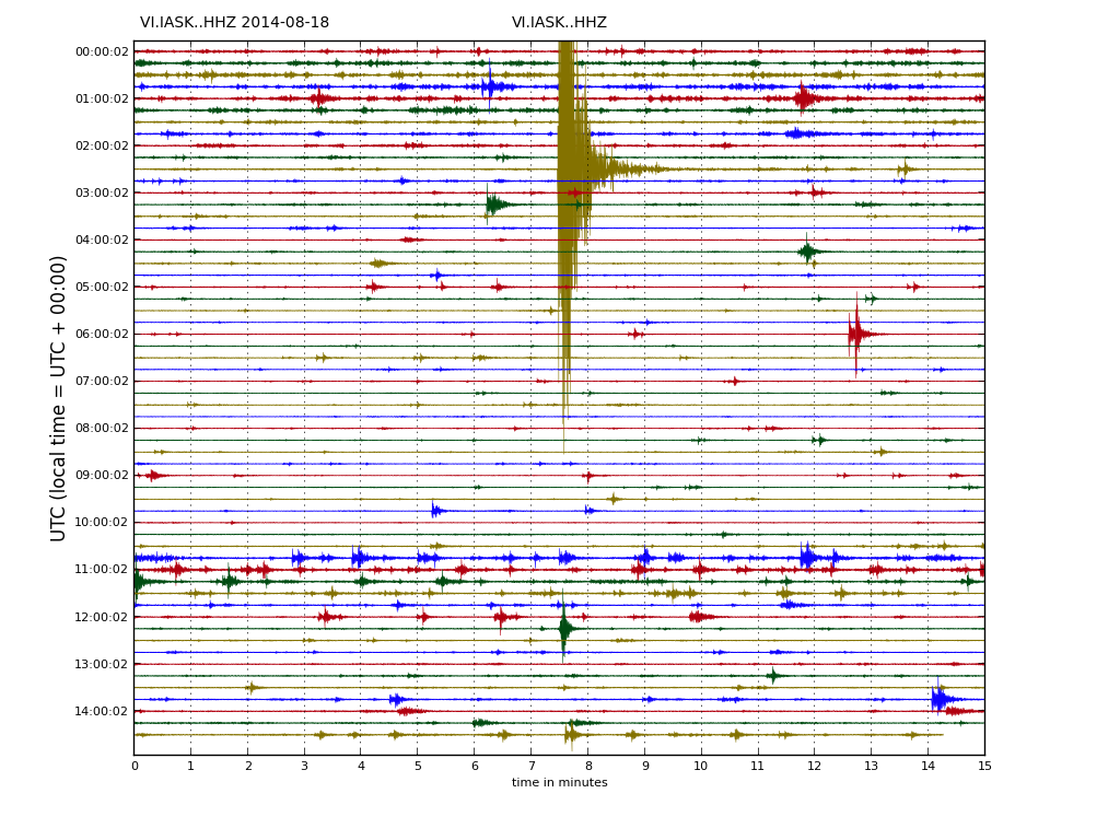
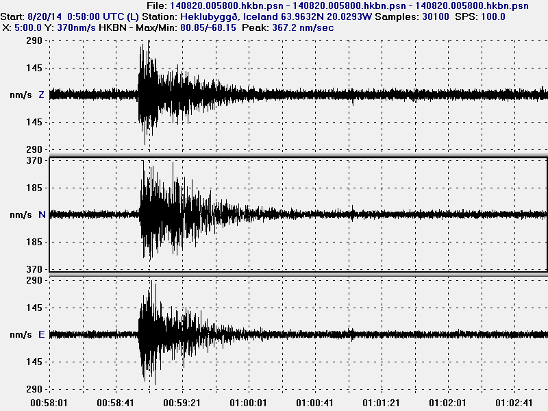
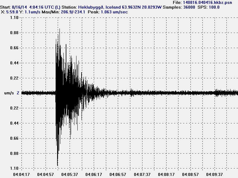
Drum plot that Icelandic Met Office has on-line are showing interesting activity. Around 11:00 UTC there is a string of earthquakes, following this activity a increase in harmonic tremor takes place. Copyright of this image belongs to Icelandic Met Office.

IDYN.svd.18.08.2014.at14.46.utc
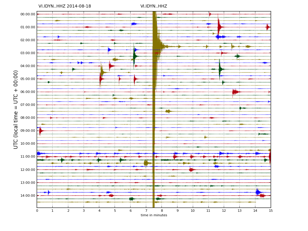
This can also be seen on Dyngjuháls SIL station. Copyright of this image belongs to Icelandic Met Office.

IKRE.svd.18.08.2014.at.14.48.utc
This also appears clearly on Kreppuhraun SIL station. Copyright of this image belongs to Icelandic Met Office.

As for amount of earthquake detected today, so far the amount recorded today is around the same as yesterday, might even be slightly higher.

Updated at 16:43 UTC.

Update on activity in Bárðarbunga at 18:13 UTC

This is a update on the activity in Bárðarbunga volcano. This information might get outdated quickly as things change.

Earthquake activity continues in Bárðarbunga volcano with no signs of stopping. Since midnight the total earthquake count for Iceland has now reached 578 (at 18:14 UTC) this number gets outdated quickly due the continuous earthquake activity in Bárðarbunga volcano. The total amount of earthquakes recorded yesterday was around 480 for the whole day, so it seems that earthquake activity has increased today from what it was yesterday. It is possible to see the largest earthquakes on my geophone website here. I want to note that my geophones are both more then 100 km away from Bárðarbunga volcano, so only the largest earthquakes appear on my geophones.

140817_1645
The earthquake activity in Bárðarbunga volcano. It has now moved into two groups of activity. Copyright of this image belongs to Icelandic Met Office.

The earthquakes are forming an line south-south-east in Bárðarbungu volcano. I don’t know why that is, but this might be a feature of the SIL network, rather then actual alignment of the earthquakes. There also chance that the earthquakes really are aligning them self into a line like this.

140817_1645_trace
Earthquake activity continues to be dense. A minor drop in activity was seen around 12:00 UTC, but it increased again around 13:00 UTC. Copyright of this image belongs to Icelandic Met Office.

There has been little drop in activity, besides the drop in activity seen around 12:00 UTC, that drop in activity however only lasted for about one hour, maybe less. There has overall not been much change in activity during the past 24 hours. I don’t know if that is going to change, but for the moment there are no signs of the activity slowing down.

dyn.svd.17.08.2014.at.17.08.utc
Harmonic tremor at Dyngjuhálsi SIL station. It moves up and down with the earthquake activity. Copyright of this image belongs to Icelandic Met Office.

von.svd.17.08.2014.at.17.07.utc
Harmonic tremor at Vonaskarð SIL station. It shows the changes in activity as other SIL stations around Bárðarbunga volcano. Copyright of this image belongs to Icelandic Met Office.

There are interesting theories on why the harmonic tremor is as it is. Currently there is nothing to suggest that an large eruption has taken place, there is a chance that a small eruption started all this, but I expect by now that it is over if it took place. It has not been confirmed. There is also a chance that earthquake activity is so high in Bárðarbunga volcano that it is registering as continuous harmonic tremor. It does not happen often, but it can happen. There is also chance that the harmonic tremor is due to boiling of hydrothermal systems in Bárðarbunga volcano, or something other related to magma under heavy pressure. Whatever the reason for this tremor, it’s there and an eruption does not seems to be the reason behind it.

Visual observations have now been made of Bárðarbunga volcano and nothing has been seen on the surface of the glacier. Scientists are also installing new monitoring hardware and a web-camera on Bárðarbunga volcano in order to get proper visual observations of the volcano when something happens. I don’t expect the web-camera to be a public at the moment.

Short update on Bárðarbunga volcano at 02:12 UTC

This is a short update on Bárðarbunga volcano activity.

Earthquake activity continues in Bárðarbunga volcano and shows no signs of slowing down. Two swarms have appeared in Bárðarbunga volcano system. One is at location called Kistufell, while the second one is at the south-east part of the Bárðarbunga volcano. Increase in earthquake activity in south-east part of Bárðarbunga volcano seems to increase harmonic tremor. I am not sure why that is. As of now (when this is written) no eruption has been confirmed in Bárðarbunga volcano, the volcano is under glacier so confirmation is difficult at best.

140817_0140
Earthquake activity in Bárðarbunga volcano. The two groups of earthquake swarms are visible on this map. Copyright of this image belongs to Icelandic Met Office.

140817_0140_trace
Earthquake activity has been dense as can be seen here. Copyright of this image belongs to Icelandic Met Office.

dyn.svd.17.08.2014.at.01.58.utc
Harmonic tremor remains high on the Dyngjuháls SIL station. Why that is not clear at the moment. Copyright of this image belongs to Icelandic Met Office.

von.svd.17.08.2014.at.01.58.utc
Harmonic tremor remains high at Vonarskarð SIL station. It has dropped little during the day, but it remains constant at current time. Copyright of this image belongs to Icelandic Met Office.

So far no major eruption has started in Bárðarbunga volcano. That might change without warning as this activity continues. There is a risk of large earthquakes taking place before such eruption. Since the crust in this part of Iceland is thick (up to 40 km thick) and last eruption in Bárðarbunga volcano took place in the year 1794. The eruption in the year 1910 took place in a volcano named Hamarinn and is south-west of Bárðarbunga volcano. Fissure eruptions are also a feature that Bárðarbunga volcano has, if this activity is going to result in such eruption is something that is impossible to know at current time.

Current status changes fast. I post new information on this activity as needed and as things get more clearer on what is happening.

Short update Bárðarbunga volcano at 17:52 UTC

This is a short update on current status on Bárðarbunga volcano.

Uncertainty level has been declared on Bárðarbunga volcano and it status has been raised to yellow. There are fluxuation in earthquake activity, this is normal since earthquake activity in volcanoes is never close to constant in this type of situations. There is also a storm taking place in the area at the moment, that is lowering what is detected by the SIL stations that are close to Bárðarbunga volcano.

140816_1705
The earthquake activity in Bárðarbunga volcano. Green stars show earthquake larger than magnitude 3,0. Copyright of this image belongs to Icelandic Meteorological Office.

Largest earthquakes recorded so far have the magnitude of 3,1 and 3,5. There is a chance that more magnitude 3,0 have taken place but have not been reviewed yet by geologist at Icelandic Meteorological Office due the amount of earthquakes taking place at the moment.

140816_1710_trace
As can be seen here the earthquake swarm is dense. Copyright of this image belongs to Icelandic Meteorological Office.

dyn.svd.16.08.2014.17.12.utc
Harmonic tremor in Dyngjuháls SIL station. It has been dropping in the past few hours. Copyright of this image belongs to Icelandic Meteorological Office.

von.svd.16.08.2014.17.12.utc
Harmonic tremor in Vonarskarð SIL station. The drop in harmonic tremor also appears clearly here. Copyright of this image belongs to Icelandic Meteorological Office.

hus.svd.16.08.2014.17.13.utc
Harmonic tremor in Húsbóndi SIL station. The drop in harmonic tremor also appears here clearly. Copyright of this image belongs to Icelandic Meteorological Office.

In the past few hours the harmonic tremors around Bárðarbunga volcano have been dropping slowly. The drop in harmonic tremor has not been followed by drop in earthquake activity. At least that is not the case when this is written. This means that the magma that is on the move there still has not yet found a pathway to the surface, even if some small part of it has done so in possibly in one or two eruptions vents under the thick glacier. If the harmonic tremor stops completely without the earthquake activity stopping it means that magma is still on the move there and it might look for a new pathway to the surface. When and where that might happen is impossible to know at current time, but once the magma has clear path to the surface, even if it is under a glacier all earthquake activity is going to stop (for most part).

I am going to post more information when more details are available.

Unconfirmed eruption in Bárðarbunga volcano

This information is going to get outdated quickly as more information is collected on this activity.

During all last week (Week 33) there has been a minor earthquake swarm in Bárðarbunga volcano. No other activity followed this minor earthquake activity during the week until last night (16-August-2014). During the night (around 02:20 UTC) a harmonic tremor started to appear on SIL stations around Bárðarbunga volcano. Following the appearance of the harmonic tremor earthquake activity started around 03:30 UTC. Largest earthquakes in this swarm have magnitude around 3,0 so far. Depth is around 5 to 10 km. During the night the earthquake swarm moved around in the volcano and is now more east then it first started. According to Rúv news the glacier around this part of Vatnajökull glacier is around 700 meters thick, so it going to take a major eruption to break the ice. This however also means that when a glacier flood starts in this area there is a high risk that is going to be large.

140816.040416.hkbz.psn
The largest earthquake that I did record during the night. This image is released under CC Licence. Please see CC Licence page for more details.

140816_1145
The earthquake swarm in Bárðarbunga volcano at 11:45 UTC. Copyright of this image belongs to Icelandic Meteorological Office.

dyn.svd.16.08.2014.12.01.utc
Harmonic tremor on Dyngjuháls SIL station. This SIL stations is closest to the area of activity in Bárðarbunga volcano. Copyright of this image belongs to Icelandic Meteorological Office.

von.svd.16.08.2014.12.02.utc
Harmonic tremor on Vonaskarð SIL station. This is one of the SIL station that is closest to the area of activity in Bárðarbunga volcano. Copyright of this image belongs to Icelandic Meteorological Office.

Currently the activity in Bárðabunga volcano is not stable, it does fluctuate a little. Besides this minor fluctuation it seems stable. Based on harmonic tremor signal and its range this does not appear to be a large eruption so far. That might change without warning. I do however expect larger earthquakes before any major volcano eruption in Bárðarbunga volcano. What seems to have happened is that a dike intrusion got to the surface and started this eruption, even if it is just small one at current time.

I am going to post update soon as more information gets available. This situation is going to change quickly and without much warning.

Earthquake activity in Þórðarhyrna, Bárðarbunga and Kverkfjöll volcanoes

Today (03-June-2014) there was a lot of minor earthquake activity in several volcanoes in Vatnajökull glacier. This is normal earthquake activity and so far nothing to worry about. This appears to be normal micro-earthquake activity in this volcanoes and I don’t see anything suggesting that volcano eruption is going to happen soon.

140603_1615
Earthquake activity today in volcanoes in Vatnajökull glacier. Copyright of this image belongs to Icelandic Meteorological Office.

Þórðarhyrna volcano

Þórðarhyrna volcano (No GVP link. It is under Grímsfjall volcano GVP information) has been having interesting activity for the past few days. It might have been ongoing longer without being noticed until now. This earthquake activity is interesting since there is normally no earthquake activity in this volcano. Last eruption in Þórðarhyrna volcano took place in the year 1902. Activity in Þórðarhyrna volcano is often connected to eruptions in Grímsfjall volcano.

Bárðarbunga volcano

Some minor earthquake activity has been taking place in the area around dike intrusion location in Bárðarbunga volcano. This is just a minor activity and nothing to worry about.

Kverkfjöll volcano

Some minor earthquake activity is taking place in Kverkfjöll volcano. This earthquake activity is just minor. It is unusual to have earthquake activity in Kverkfjöll volcano. This earthquake activity is clearly a signal of increase of activity in Kverkfjöll volcano, it however does not signal that an eruption is imminent in Kverkfjöll volcano. So far everything remains quiet and might be so for a good while longer. Last eruption in Kverkfjöll volcano was in the year 1968.

Donations: Please remember to support my work with donations. If you buy from Amazon (please choose your correct Amazon site before you shop) I get 5 to 10% of the sale as income of every item sold. Thanks for the support.

New earthquake swarm in Bárðarbunga volcano

On 20-May-2014 an earthquake swarm started in Bárðarbunga volcano or a continuum of an earthquake swarm that started on 16-May-2014 as I wrote about here. This earthquake swarm was rather small, with the largest earthquake only having the magnitude of 2,8 according to reviewed results from Icelandic Meteorological Office.

140521_2220
The earthquake swarm in Bárðarbunga volcano. Copyright of this image belongs to Icelandic Meteorological Office.

This earthquake swarm activity seems to be due to minor dike intrusion into Bárðarbunga volcano at this location. It does not mean an eruption is about to take place. More earthquake activity might take place this location in next days to weeks.

Magnitude 3,7 earthquake in Bárðarbunga volcano

Today (16-May-2014) a magnitude 3,7 earthquake took place in Bárðarbunga volcano. The source of this earthquake is not clear, but this appears to be a magma injection into Bárðarbunga volcano. Such events do happen in Bárðarbunga volcano without starting an eruption.

140516_2125
The magnitude 3,7 earthquake in Bárðarbunga volcano. The earthquake took place where the green star is. Copyright of this image belongs to Icelandic Meteorological Office.

140516.144100.hkbz.psn
The Bárðarbunga volcano earthquake as it appeared at my geophone station in Heklubyggð. This image is released under Creative Commons Licence. Please see CC Licence for more details.

There was around 20 aftershocks following this earthquake. Largest automatic magnitude was 2,6, but strongest reviewed earthquake activity so far had the magnitude of 2,5. More earthquake activity is most likely going to continue in this area. Earthquakes with this or stronger magnitude cannot be ruled out from happening. There is currently nothing suggesting that this is other then just normal earthquake activity in Bárðarbunga volcano.

Donations: Please remember to support my work with donations or by buying via the Amazon links that I have here. With Amazon I get 5 to 10% of each sold item that is bought via my website. Thanks for the support.

Minor earthquake swarm in Bárðarbunga volcano

Yesterday (26-April-2014) and today (27-April-2014) an minor earthquake swarm took place in Bárðarbunga volcano. I am not sure if this earthquake activity is due to dike intrusion or normal tectonic activity.

140427_1400
Minor earthquake swarm in Bárðarbunga volcano. Copyright of this belongs to Icelandic Meteorological Office.

This area of Bárðarbunga volcano is well known for high earthquake activity. If this is an dike intrusion as is an possibility, it does not increase the risk of an eruption, since dike intrusion without starting an eruptions are a common feature in Icelandic volcanoes.

Minor dike intrusion into Bárðarbunga – Hamarinn volcanoes

It seems that yesterday (02-September-2013) a minor dike intrusion took place in Bárðarbunga – Hamarinn volcanoes. This created an minor harmonic tremor yesterday on nearby sil stations. There were earthquakes following this events, the strongest one had the magnitude of 2.8 at the depth of 14 km. A second earthquake with the magnitude of 2.1 took place few moments later, it had the depth of 15.5 km. Only one smaller earthquake have seen taken place in this area of Bárðarbunga – Hamarinn volcanoes.

130903_1920
The earthquake activity in Báðarbunga – Hamarinn volcano area. Copyright of this image belongs to Icelandic Meteorological Office.

It is important to notice that dike intrusions are common in this area, often happen many times a year. How many takes place can vary between years. That dike intrusion took place does not mean an eruption is going to take place. It just means that magma moved, what that means for the future is unknown at present time.

Donations: It would be nice if people donated so that I can buy food this month. In other case I am going to have to eat really little this month and I am not happy about such things taking place.

Blog post updated at 21:43 UTC on 3-September-2013.