Magnitude 3,4 earthquake in Bárðarbunga volcano, earthquake swarm on eastern TFZ

This is just a short overview of activity in the last 24 hours (or so) in Iceland.

Bárðarbunga volcano

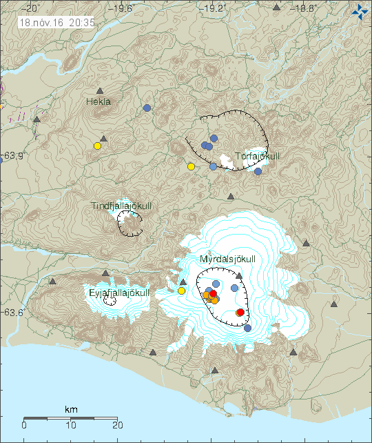
As usual Bárðarbunga volcano had an magnitude 3,4 earthquake this week. This time it only appears to have been just a one earthquake. Based on the signature of this earthquake, there is a good chance it was created by magma, rather than tectonic processes.

160531_1635
Bárðarbunga volcano earthquake. Copyright of this image belongs to Iceland Met Office.

I expect this earthquake activity to continue for a while now.

Tjörnes Fracture Zone (TFZ)

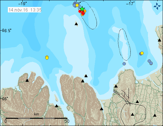
A small earthquake swarm took place in eastern TFZ this morning. This was not a large earthquake swarm, with the largest earthquake having the magnitude 2,0. Around 40 or so earthquakes took place in this minor swarm.

160531_1735
The earthquake swarm on TFZ, close to the village of Kópasker. Copyright of this image belongs to Iceland Met Office.

This earthquake swarm is over and I don’t think it is going to start again. Earthquake swarms like this one are common on TFZ.

Donations

Please remember to support my work with donations or by using Amazon when you shop. Thanks for the support. 🙂

Grímsfjall volcano preparing for an eruption (also known as Grímsvötn)

On Wednesday 25-May-2016 a small earthquake swarm took place in Grímsfjall volcano (also known as Grímsvötn), none of the earthquakes that took place managed to reach the magnitude 1,0, many of the earthquakes where shallow and might be glacier movement, rather than actual earthquakes, but in I find it unlikely reason.

160526_1330
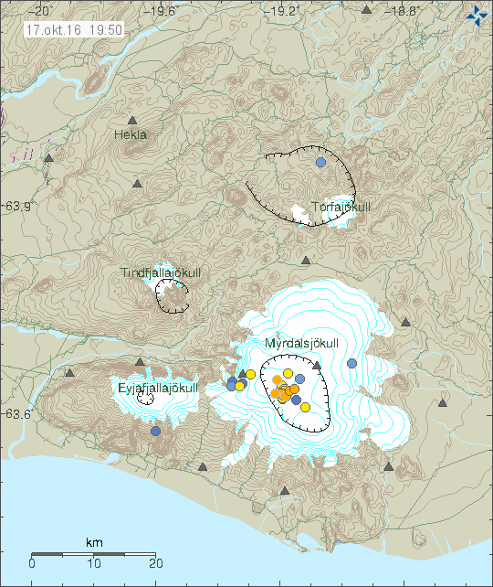
Earthquake activity in Grímsfjall volcano (red dots, blue dots). Copyright of this image belongs to Iceland Met Office.

Since 2011 Grímsfjall volcano has been preparing for an eruption. The eruption in 2011 was the largest one in 140 years at least (VEI=4). The average time between eruptions in Grímsfjall volcano around 5 to 7 years (based on known eruption history). How long it is going to take until Grímsfjall volcano is ready for a new eruption is impossible to know, the current data however suggests that next eruption might not be that many years away. GPS data and other interesting information can be found here.

Magnitude 4,4 earthquake in Bárðarbunga volcano

Today (20-May-2016) a magnitude 4,4 earthquake took place in Bárðarbunga volcano. This is the strongest earthquake so far since the end of the eruption in February-2015. This earthquake swarm also had two magnitude 3,3 earthquakes. Other earthquakes where smaller in magnitude.

160520_1300
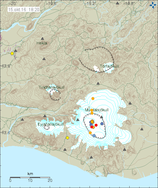
The earthquake activity in Bárðarbunga volcano. Copyright of this image belongs to Iceland Met Office.

Official statement from Iceland Met Office is that they are not sure what is going on. What is clear is that seismic energy being released from Bárðarbunga volcano has increased a lot since end of the eruption in February-2015 and current GPS data suggest rapid inflation. Both of are unusual after caldera collapse like Bárðarbunga volcano experienced in the 2014 – 2015 eruption. Due to lack of historical data it is hard to know for sure what is going on, whatever it is, it’s the first ever that is being monitored in great details.

Current events have not lead to an eruption so far. They however might do so in the future, when is difficult to know since the time frame of this development is unknown, it might be hours, it might be decades. Satellite images also show that cauldrons that have formed at the edge of the caldera are getting deeper and possibly larger, suggesting an increased hydrothermal energy at the locations where they have formed. This suggest that more magma is collecting at depth in the caldera, something as sad above is highly unusual due the recent caldera collapse in the last eruption. I’m expecting more earthquake swarms like this and growing magnitude of the earthquakes that take place. The weekly pattern is going to continue and I suspect it might increase soon, when is impossible to know for sure.

Donations

Please remember to support my work with donations (or by using Amazon). Currently my financial status is not so good (worse then what I was expecting). It will get better, just takes few months and I need to survive those months. Thanks for the help. 🙂

Earthquake activity in Bárðarbunga, Öræfajökull, Langjökull north volcanos

This is going to be a little compressed article. Since I’m currently in Iceland. I’ll be back in Denmark on 18-May. No GVP links now. I don’t think that my laptop can handle it (its slowly turning into non-functional computer).

Bárðarbunga volcano

The regular earthquake activity in Bárðarbunga volcano continues, it follows the same pattern has it has been doing for the last 7 – 8 months.

160512_2025
The earthquake activity in Bárðarbunga volcano. Copyright of this image belongs to Iceland Met Office.

The largest earthquake had the magnitude of 3,2. Other earthquakes had smaller magnitude. This earthquake activity is like the earthquake activity before, there doesn’t seems to be a lot of difference between the earthquake swarms that are now taking place between weeks.

Öræfajökull volcano

There is a interesting earthquake activity taking place in Öræfajökull volcano. It suggest that some magma is entering the volcano at depth (5 – 10 km). At the moment there is nothing that suggests an eruption is getting close, however the eruption history of Öræfajökull volcano is not well known and no reliable data exists on what might happen in the case of eruption. At the moment, all of the earthquakes taking place are minor, suggesting the amount of magma entering Öræfajökull volcano is minor at the moment.

Langjökull (north)

Today (12-May-2016) an small earthquake swarm took place in north Langjökull volcano. This earthquake activity has been taking place in this area since the year 2000, it was started by the magnitude 6,5 earthquake in SISZ. The reason for this earthquake swarm are unclear. No change in the main volcano has been observed, both in terms of earthquake activity or other changes. One idea is that this are stress changes in faults at this area, suggesting they might be lateral faults, not connected to the volcano it self.

160512_2110
The earthquake activity in Langjökull north volcano (Hveravellir). Copyright of this image belongs to Iceland Met Office.

None of the earthquakes that took place had strong magnitude, largest earthquake had the magnitude of 2,0.


New – Analyzing articles

I plan on to start writing analyzing articles about volcanoes in Iceland in order to attempt to explain what is going on with the most active one and what might happen. Those articles will take few days to write, that means I won’t write many of them each week if needed. This is also going to cover history of the volcano if that is possible. I am going to try and expand this website a little in order to bring in more readers.

Hardware support needed

Since I have to go the dentist when I go back to Denmark (sight). I can’t afford the hardware upgrade and maintaining my desktop computer (I got a failing hard drive). I also need hardware for setting up a second geophone computer in Denmark and a new Power supply for my main earthquake computer, it now running a 350W power-supply from a different computer, making it a little under powered.

Here is the list of hardware needed if anyone can help me with this.

1 500W power supply for my main earthquake computer (It has to be Intel six CPU pin power compatible).
1 1TB hard drive for my main desktop computer. The current hard drive is failing, its making clicking sounds, suggesting that its read head is about to fail.
1 1TB hard drive for my main earthquake computer. This for my main backup of all my data (earthquake data and other important data, images and so on). The second backup is on the internet. I so far haven’t been able to setup my third backup plan.
1 500GB to 1TB hard drive for my second geophone computer in Denmark.

Extra

1 Used laptop that is faster than 2,3Ghz and with more than 2GB ram. It can be used, it just has to work and be younger then 2010 model of laptop. It doesn’t have to have Windows installed on it. It does have to have a working hard drive.

Thanks for the support. 🙂

Earthquake swarm ~125 km north of Kolbeinsey Island

Donations

Please remember to support my work with donations. My main job in this writing is to convert hard to read data about earthquakes or volcanoes into human readable format. It might not sound like a lot, but it can be a time consuming work to read all the data in their raw format (if I have to) and figure out (or try doing so) what is going on at times. Thanks for the support.

Kolbeinsey earthquake swarm

This earthquake swarm started sometimes yesterday (09-May-2016) or last night (10-May-2016), the first earthquakes appeared on SIL network at 01:03 UTC. This area north of Kolbeinsey Island is located around 125 km north of it. It is thought that this area had an eruption in the last few years (I can’t find the exact year), but it was not confirmed far as I know. Mostly due the location far from the coastline. It is difficult to know for sure what is exactly going on at this location. Activity has been going up in past few months in this area.

160510_1345
The earthquake area north of Kolbeinsey Island. It is around 125 north of Kolbeinsey Island. Copyright of this image belongs to Iceland Met Office.

This area is rather unknown, but some study has been done into it. I’m sure on the details. There is a possibility that activity is going to continue in this area for next few days. If an eruption takes place, nobody is going to notice it due to distance from nearest population center (~200 km).

Earthquake activity in Bárðarbunga volcano (Week 17)

After a short period of quiet, it seems that Bárðarbunga volcano has started again making earthquake swarms. The source of this activity is the same as before, inflation of Bárðarbunga volcano and infiltration of magma at shallow depth (that might not erupt).

160502_1435
The earthquake activity in Bárðarbunga volcano. Copyright of this image belongs to Iceland Met Office.

Largest earthquake in this swarm had the magnitude of 3,4. Other earthquakes in this swarm had smaller magnitude. The number of earthquakes in this swarm was typical, around 20-ish. Currently the activity has stopped, but it is going to start again in few days, as has been the pattern since end of the eruption in February 2015.

160501.192500.hkbz.psn
The magnitude 3,4 earthquake as it appeared on the vertical axes (Z) in Heklubyggð geophone. The signal is filtered at 2Hz. This image is under Creative Commons License. Please see CC License for more details.

Minor earthquake swarm on Tjörnes Fracture Zone

Today (11-April-2016) at 16:49 UTC an earthquake swarm started on Tjörnes Fracture Zone. This was a short earthquake swarm and only lasted for 15 minutes before it stopped.

160411_2050
The earthquake swarm on Tjörnes Fracture Zone. Copyright of this image belongs to Iceland Met Office.

Largest earthquake in this swarm had the magnitude of 3,2. The second largest earthquake in this swarm had the magnitude of 3,0. Other earthquakes where smaller in magnitude. This earthquake swarm is over for now.

My laptop

My laptop is now showing clear signs that its about end its usefulness and a complete hardware failure is imminent. I don’t expect to use it a lot after Friday. If it fails before that time I won’t be able to post updates for the next two days (until 14-April-2016).

Donations

Please remember to support my work with donations. Thanks for the support. 🙂

Magnitude 4,2 earthquake in Bárðarbunga volcano

Shortly after midnight of 8-April-2016 a magnitude 4,2 earthquake took place in Bárðarbunga volcano. This earthquake activity was shallow, most depth was around 3 to 5 km. Few earthquakes took place at 7 to 11 km depth, suggesting a magma movement at depth. Nothing suggest that magma reached shallow depth this time around.

160408_1240
The earthquake activity in Bárðarbunga volcano. Copyright of this image belongs to Iceland Met Office.

The second largest earthquake in this activity had the magnitude of 3,5 at the depth of 4,3 km. Other earthquakes in this swarm where smaller in magnitude at different depths. Magma did not reach the surface in this earthquake swarm, this appears to have been a movement of fault lines do to stress changes at depth due to magma inflow. I’m expecting continued earthquake activity in Bárðarbunga volcano in coming weeks and months.

Donations and move to Denmark

I want to remind people of this article here. I also want to remind people to support my work with donations. Thanks for the support. 🙂

Deep earthquake activity in Askja volcano

Yesterday (06-April-2016) a swarm of deep earthquakes took place in Askja volcano. None of the earthquakes that took place where large in magnitude, with the largest one having a magnitude of 1,6.

160407_1235
Earthquake activity in Askja volcano, close to Dreka (dragon). Copyright of this image belongs to Icelandic Met Office.

Main depth of this earthquake swarm was around 21 km. It did not go up in the crust and nothing suggests that it is going to do so at this point in time. No change in harmonic tremor took place during this earthquake swarm.

Thanks for donations

I want to thank everyone that has donated to support me during April and other months of the year. Once I’m back in Denmark I am going to get me a job so that I have higher income and can live in Denmark for good (and stop being broke all the time). Details about my current status can be found here.

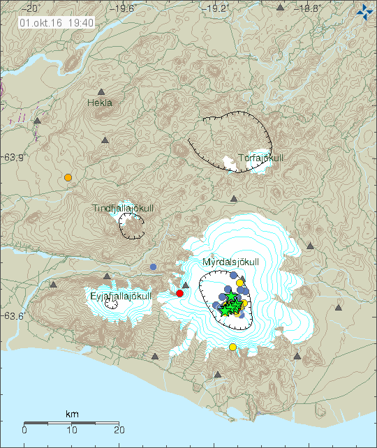
Earthquake activity in Bárðarbunga and Grímsfjall volcanoes

Yesterday (17-March-2016) an earthquake swarm took place in Bárðarbunga volcano. This is a weekly cycle at the moment in Bárðarbunga volcano so older readers are used to seeing and read about it already. This started in September 2015 (for the new readers) after the eruption in Holuhraun ended in February 2015. This activity suggest that magma has started to flow into the magma chamber in Bárðarbunga volcano again at faster speeds than before the eruption in Holuhraun. The exact rate is difficult to know, since the magma that started the eruption in Holhraun had been building up in Bárðarbunga volcano since 1970-ish and part of that time earthquake recording was poor or did not exist in Iceland or parts of it until 1995 when the SIL network was created by Veðurstofa Íslands.

160318_0000
The earthquake activity in Bárðarbunga and Grímsfjall volcanoes. Copyright of this image belongs to Iceland Met Office.

The largest earthquake this week had the magnitude of 3,4 while other earthquakes that took place had smaller magnitude. The second largest earthquake had the magnitude of 2,8. Other earthquakes where smaller in magnitude. It is also interesting that part of the earthquake swarm aligned it self along north-south fault in the eastern part of the caldera. That is a new feature, either a weakness is forming at this location or something else is up. This area has around 300 – 500 meter thick glacier on top of it and an eruption at this location would be extremely bad. The glacier flood from eruption at this location would mostly go down Jökulsá á fjöllum glacier river. Other flood locations can’t be ruled out (I’m not an expert on glacier floods and I do have limited knowledge of the landscape under the glacier).

Grímsfjall volcano

It has been five years since Grímsfjall volcano erupted in a largest eruption in 140 years for Grímsfjall volcano. Over the past few weeks there has been a slight increase in earthquake in Grímsfjall volcano. At the moment this doesn’t mean an eruption is imminent, the thing however about eruptions in Grímsfjall volcano is that they happen suddenly and without warning. Normally eruption happens in Grímsfjall volcano every 3 – 5 years on average, sometimes its shorter and sometimes its longer between eruptions.

Notice on Böðvarshólar geophone station

For the longest time now I’ve been having 3G connection issues with Böðvarshólar geophone station. The problems include poor signal, little bandwidth. The poor signal leaks into my recording of earthquakes, making them bad and extremely noisy and that makes them less usable for me. I am going to attempt to improve this situation but if that fails I will have to turn the station down. Since the cost of getting a good antenna for this location is too high and the solution takes too long to implement anyway. I will post a notice if I take down the Böðvarshólar geophone station. If it happens, it is going to happen before I move to Denmark.

Article updated on 18-March-2016 at 13:31 UTC. Minor spelling error fixes.