Two earthquake swarms in Iceland today (02-June-2017)

Today (02-June-2017) there have been two earthquake swarms taking place in Iceland. Both are minor in terms of magnitude, the second earthquake swarm is now getting close to 60 – 80 earthquakes at the moment.

Western Icelandic Seismic Zone

This earthquake swarm is taking place on the edge of the slow moving Western Icelandic Seismic Zone (as I call it). This is a earthquake active zone between Langjökull, Snæfellsnes and Vestfjörð up to Táknafjörður village. It sometimes has earthquakes with magnitude up to 5.5.


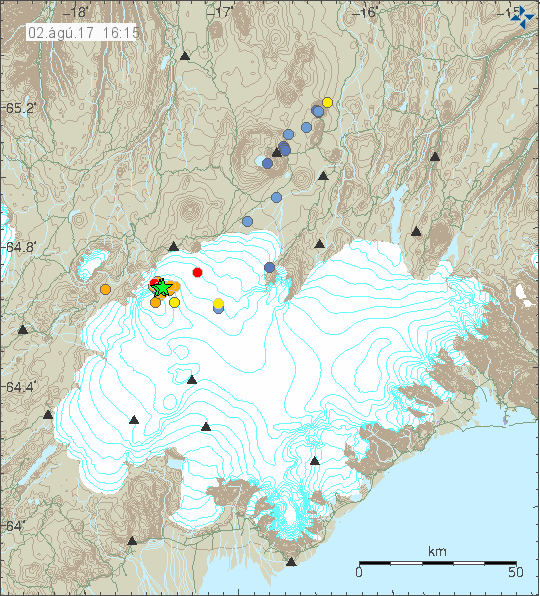
The earthquake swarm in western Iceland. I don’t think anyone of this earthquakes did go above magnitude 2,0. Copyright of this image belongs to Icelandic Met Office.

Herðubreið – Herðubreiðartögl

Also today there has been a earthquake swarm in Herðubreið and Herðubreiðartöglum. This is a common earthquake swarm. Far as I know none of the earthquakes that have happened so far have reached magnitude 2,0 at the moment. As this earthquake swarm is currently ongoing it is impossible to know for sure what happens next.


The earthquake swarm in Herðubreið and Herðubreiðartöglum (to the north-east of Bárðarbunga volcano). Copyright of this image belongs to Icelandic Met Office.

What is known is that magma has been migrating in this direction, but at this moment there is nothing suggesting that this magma has found a path to the surface and it remains at ~15 km depth. Earthquake swarms in this area normally last up to two weeks at the most.

Iceland geology Twitter

I have now moved this website to its own twitter account. It cuts out the noise on my own personal twitter account. It is possible to follow Iceland geology on twitter by pressing this button.

Donations

Please remember to support my work with donations. It appears that June is going to be a difficult month as was the case with May (I just scraped May with minimal money). Thanks for the support. 🙂

Weekly earthquake activity in Bárðarbunga volcano (1-June-2017)

Today (01-June-2017) a earthquake swarm took place in Bárðarbunga volcano. This earthquake swarm was in the regular location at north-east part of the caldera. Two earthquakes with magnitude 3,2 took place and one magnitude 3,6 earthquake happened. Other earthquakes in this activity where smaller in magnitude.


The earthquake activity in Bárðarbunga volcano today (01-June-2017). Copyright of this image belongs to Icelandic Met Office.

Earthquake activity in Bárðarbunga volcano is now getting close to weekly again. This suggest that magma inflow into the volcano is increasing again. What that means in the long term is unclear at this moment. Sometimes there is just one earthquake, but in most earthquake events there are now more than one earthquake with magnitude above 3,0.

Donations

Please remember to support my work. June is also going to be rather poor month for me due to dentist costs. I am hoping this is the last of it and July is going to be better. That still leaves me to make it trough June. Thanks for the support. 🙂

Earthquake activity far east of Iceland continues

Today (30-May-2017) Icelandic Met Office has registered a magnitude 3,8 earthquake far east of Iceland, around 370 km from the east Iceland coastline. This earthquake location is registered as close to the earlier earthquake activity in the same area. That might just be an calculation error due to distance from the SIL network. This earthquake activity has not been registered by EMSC.


The green star shows the location of this earthquake. Copyright of this image belongs to Icelandic Met Office.

There have been smaller earthquakes in the same area for the last few days. This appears to be intra-plate earthquake activity, this sometimes happens in Iceland and most recent earthquake activity like this took place in 2006 in Vestfjörð close to Djúpavík. That earthquake swarm lasted for a good one and a half week. What is happening at this location is mostly unknown, this applies to number of earthquakes happens. Only the strongest earthquakes are being recorded due to the distance from the SIL network.

Donations

Please remember to support my work with donations. Thanks for the support. 🙂

Strong earthquake in Bárðarbunga volcano (27-May-2017)

Today (27-May-2017) at 09:36 UTC a magnitude 3,9 earthquake took place in Bárðarbunga volcano. This is a normal earthquake activity in Bárðarbunga volcano. Depth of this earthquake activity is now around 7 km. Other earthquakes in this swarm where smaller in magnitude.


Earthquake activity in Bárðarbunga volcano. Green star shows the magnitude 3,9 earthquake. Copyright of this image belongs to Icelandic Met Office.

Recent reports from Iceland Civil Disaster Management (Almannavarnir) and Icelandic Met Office there is considerable hydrothermal activity in the caldera and on its rim. Suggesting that Bárðarbunga volcano has not started to cool down after Holuhraun eruption. In the long run this means that there is a good chance that current eruption cycle is far from being over.

Donations

Please remember to support my work. Thanks for the support. 🙂

Earthquake swarm ~338 km east of Iceland (close to Faeroe Islands)

During the last 24 hours or so there has been some activity ~334 km east of Iceland. Largest earthquakes detected have had the magnitude of 3,1 and 3,1 and this are the only earthquakes that have been detected.


The earthquake activity way off the east coast of Iceland. This activity is closer to Faeroe Islands than Iceland. Copyright of this image belongs to Icelandic Met Office.

I have little knowledge about what is below the waves at this location. Depth at this area is around 2 – 3 km and no known volcano or fault area is at this exact location. Next ancient fault area is slight more to the north, that feature is called Aegir Ridge and is extinct. This earthquake activity is slight outside it but within its area it might effect. This might be a intra-plate earthquake activity, since this area is not active and has not been for millions of years according to studies.

Donations

Please remember to support my work with donations, they help me survive. Thanks for the support. 🙂

Earthquake swarm in Kolbeinsey island

Yesterday (24-May-2017) and today (during the night of 25-May-2017) there was an earthquake swarm in Kolbeinsey island. Largest earthquakes had the magnitude of 3,6 (x2) and one magnitude 3,5 earthquake took place. Other earthquakes where smaller in magnitude. No harmonic tremor where detected during this activity, that does not rule out that this activity is due to dyke intrusion taking place in Kolbeinsey island. It just didn’t reach the surface this time. Kolbeinsey island is far away from the SIL network, with the closest station being in Grímsey island (~25 km) with other SIL station at ~60 km distance. If an eruption starts in Kolbeinsey Island, a harmonic tremor signal is going to appear in Grímsey island SIL station.


Green star mark the area where the earthquake swarm took place in Kolbeinsey island. Copyright of this image belongs to Icelandic Met Office.

Last eruption in this area took place in the year 1755, but that eruption might not actually have been in Kolbeinsey Island, but in a other unnamed volcano north of it (where is not known). Last confirmed eruption in Kolbeinsey island took place in the year 1372, it was closer to land somewhere north-west of Grímsey island (suggesting that fissure swarm of Kolbeinsey island comes close to Grímsey island).

At the moment the activity has quieted down and no earthquakes are being detected by the SIL network.

Donations

Please remember to support my work with donations. Thanks for the support. 🙂

Strong earthquake activity in Bárðarbunga volcano yesterday (20-May-2017)

Yesterday there was a strong earthquake activity in Bárðarbunga volcano (GVP has new information about Bárðarbunga volcano). Two of the largest earthquakes had the magnitude of Mw3,9 and Mw3,8 other earthquakes where smaller in magnitude and around 10 earthquakes happened in Bárðarbunga volcano. This activity is also different from historical activity from 1970’s and towards 1994 (Gjálp eruption), when a magnitude 5 earthquake would happen in Bárðarbunga volcano once to twice a year. Current activity suggests that magma is inflating Bárðarbunga volcano faster than in the period between 1970’s and 1994. Why that is is not known to me.


The earthquake activity in Bárðarbunga volcano. Copyright of this image belongs to Icelandic Met Office.

Current change is that in recent weeks there are fewer earthquakes taking place in Bárðarbunga volcano, but when they happen they are often larger in magnitude and more than one large earthquake happens during the earthquake swarm.


The magnitude (Mw) 3,8 earthquake in Bárðarbunga volcano as it appeared on my geophone in Böðvarshólar. This image is under Creative Commons Licence, see CC licence for more details.


The magnitude (Mw) 3,8 earthquake in Bárðarbunga volcano as it appeared on my geophone in Heklubyggð. This image is under Creative Commons Licence, see CC licence for more details.


The magnitude (Mw) 3,9 earthquake in Bárðarbunga volcano as it appeared on my geophone in Böðvarshólar. This image is under Creative Commons Licence, see CC licence for more details.


The magnitude (Mw) 3,9 earthquake in Bárðarbunga volcano as it appeared on my geophone in Heklubyggð. This image is under Creative Commons Licence, see CC licence for more details.

According to reports on Global Volcanism Program the most magma collection is happening at the depth of 10 km (or around that depth), no clear or oblivious signs are that magma is collecting at shallower depth at the moment. If that is required for a eruption in Bárðarbunga volcano is not know at the moment, there is a possibility that magma might collect at 10 km depth and then pump out with a dike as was seen in the Holuhraun eruption (2014 – 2015). What has been confirmed is that magma is collecting under Bárðarbunga volcano and the volcano is inflating. This inflation is either going to stop or its going to continue until a new eruption happens.

Donations

Please remember to support my work here. While it is quiet in Iceland some days to weeks that can change without warning. I mostly update when something is happening in Iceland since I write mostly about current events. Thanks for the support. 🙂

Earthquake activity in Tjörnes Fracture Zone (TFZ)

For the past month (or so) there has been a constant earthquake activity close to Flatey island on the Tjörnes Fracture Zone (TFZ). This earthquake swarm has not been strong, with majority of the earthquakes only having the magnitude of 0,0 – 2,5 and only one or two earthquakes with magnitude 2,8 – 3,0. While this earthquake swarm might not be a risk, it might suggest that something is about to give in this area.


The earthquake activity in TFZ as it is today. The activity close to Flatey island is clearly visible. Copyright of this image belongs to Icelandic Met Office.

Other areas of TFZ have also been having minor earthquake swarms. I don’t think they are connected to this activity near Flatey island. None of those earthquake swarm have been big in both number of earthquakes and magnitude. TFZ is Iceland most active earthquake area with hundreds of earthquakes taking place each year. What is unusual now is the earthquake activity close to Flatey island, but this is not the first time this type of earthquake swarm happens in TFZ. Normally this type of earthquake swarm slowly die out without anything major happening.

Donations

Please remember to support my work. I haven’t written many articles here in recent days due to lack of activity in Iceland. That lack of activity was both quiet times and due to bad weather taking place in Iceland (wind did go up to 45 – 50m/s). Thanks for the support. 🙂

Earthquake swarm in SISZ (South Icelandic Seismic Zone)

Today on 6-May-2017 a magnitude 4,4 – 4,5 earthquake hit South Icelandic Seismic Zone (SISZ) at 12:08:58 UTC. This earthquake was felt over a wide area, a magnitude 3,3 earthquake also took place around one minute after the main earthquake. The earthquake took place on a fault that might have last moved in the year 1623 or 1624, as is detailed here. Current earthquake activity does classify as a “Suðurlandsskjálfti”, only earthquakes with magnitude above 5,5 are classified as such. This is regardless a strong earthquake activity in SISZ for a long time now.


The earthquake activity on SISZ. The green stars mark the location of the magnitude 4,4 – 4,5 and the magnitude 3,3 earthquakes. Copyright of this image belongs to Icelandic Met Office.


The magnitude 4,4 – 4,5 earthquake as it appeared on my geophone in Böðvarshólar, north-west Iceland. This image is under Creative Commons Licence, please see CC licence page for more details.


The magnitude 4,4 – 4,5 earthquake as it appeared on my geophone in Heklubyggð, the earthquake happens just west of this geophone location. The geophone is saturated by incoming earthquake signal. This image is under Creative Commons Licence, please see CC licence page for more details.


The magnitude 3,3 earthquake as it appeared on my geophone in Heklubyggð, the earthquake happens just west of this geophone location. This earthquake also saturates the geophone (just a little). This image is under Creative Commons Licence, please see CC licence page for more details.

More aftershocks are expected in this are for the next few hours to days. It is difficult to know if this means there is going to be a larger earthquake activity at this location or nearby. It’s always a chance, but it is not possible to know that for sure.

Donations

Please remember to support my work with donations. May is rather difficult month for me financially. Thanks for the support. 🙂

Article has been updated at 15:55 UTC. Minor text fixes.

Magnitude 4,3 earthquake on the Reykjanes ridge today (19.04.2017)

Today (19.04.2017) at 12:34 UTC an earthquake with the magnitude of 4,3 took place on the Reykjanes ridge. This earthquake was felt in Keflavík town and nearby areas. A swarm of aftershocks followed, none of them was above magnitude 3,0. Largest aftershock had the magnitude of 2,9.


The earthquake swarm on the Reykjanes Ridge. Green star is the location of the magnitude 4,3 earthquake. Copyright of this image belongs to Icelandic Met Office.

This earthquake activity appears to be normal rifting activity in line with earlier earthquakes like this that have been happening deeper on the Reykjanes ridge over the past few weeks. There is a good chance that new earthquake activity is going to happen in this same area or nearby area in next days to months.


The earthquake as it appeared on my geophone in Heklubyggð. This image is released under Creative Commons Licence. Please see CC Licence website for more details.

Donations

Please remember to support my work with donations. Thanks for the support. 🙂