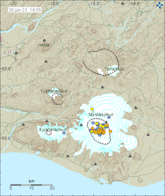
Today (26. June 2023) the earthquake activity in Katla volcano increased again for few hours. Largest earthquake this time had a magnitude of Mw2,5. This earthquake activity has slowed down again. This earthquake activity is ongoing, even if there is no activity at the writing of this article.
Earthquake activity in Katla volcano. Copyright of this image belongs to Icelandic Met Office.
Its is still unclear what is going on in Katla volcano. There was no change in harmonic tremor following this earthquake activity. Showing that magma did not move in any obvious way when this earthquake activity took place.
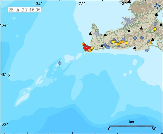
Today (26. June 2023) an earthquake swarm took place in Reykjanes volcano. This earthquake swarm is in a location in Reykjanes volcano that has been having repeated earthquake activity over the last few months. This strongly suggest that at this location there’s an active dyke that might erupt in the future.
Earthquake swarm in Reykjanes volcano. Copyright of this image belongs to Icelandic Met Office.
Largest earthquake in this swarm at the writing of this article had a magnitude of Mw3,0. Other earthquakes have been smaller in magnitude. I am unclear on how many earthquakes have happened in Reykjanes volcano at the writing of this article. This earthquake swarm is ongoing at the writing of this article.
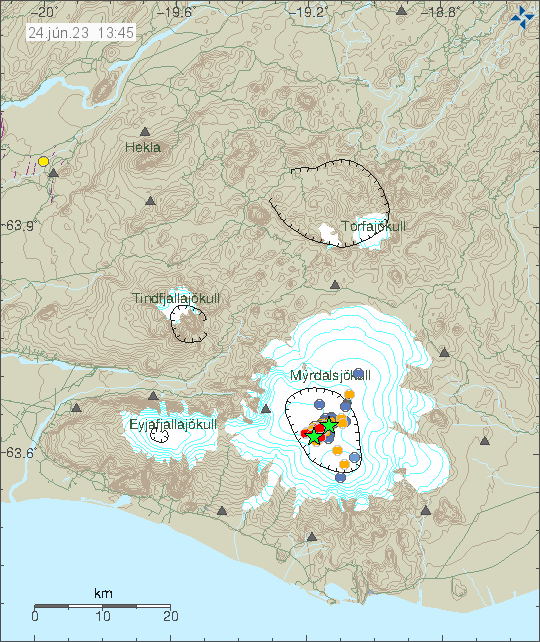
Today (24. June 2023) an earthquake swarm started in Katla volcano. Largest earthquakes had magnitude of Mw3,8 and Mw3,3. Other earthquakes have been smaller. This earthquake swarm is ongoing but has slowed down since this morning.
Earthquake activity in Katla volcano. Copyright of this image belongs to Icelandic Met Office.
At the writing of this article there is no clear sign that an eruption is about to happen. That might change without a warning. This earthquake activity might stop and nothing more is going to happen until next time. That is what has been going on for the last few months and years.
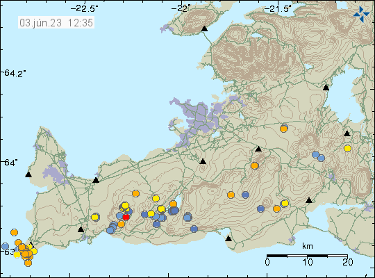
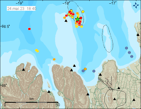
During the night of 3. June 2023 an earthquake swarm took place in Reykjanes volcano, at location called Reykjanestá. Largest earthquake in that swarm had a magnitude of Mw3,0. Other earthquakes where smaller. This earthquake swarm suggests a magma movement, but it is difficult to be sure if that is what happened now.
Earthquake activity in Reykjanes volcano and Fagradalsfjall volcano. Copyright of this image belongs to Icelandic Met Office.
Its been ten months since last eruption took place in Fagradalsfjall volcano. It is likely that a new eruption is going to happen soon, but it is impossible to know when. In last few weeks earthquake activity has been increasing in Fagradalsfjall volcano and that suggests that magma pressure inside the volcano is increasing. It just has not reached the levels to start a new eruption.
Yesterday an earthquake swarm started in Krýsuvík-Trölladyngja volcano. This earthquake swarm doesn’t appear (it might be connected, but it is difficult to know currently) to be connected to the inflation that is happening at Fagradalsfjall volcano. Largest earthquake in this earthquake swarm had a magnitude of Mw3,0. This earthquake swarm took place just south-west of Kleifarvatn lake.
Earthquake activity in Krýsuvík volcano. Copyright of this image belongs to Icelandic Met Office.
This earthquake swarm doesn’t seems to indicate an magma movement. There has not been any indicators (clear) that Krýsuvík-Trölladyngja volcano has gone active. It remains a dormant volcano.
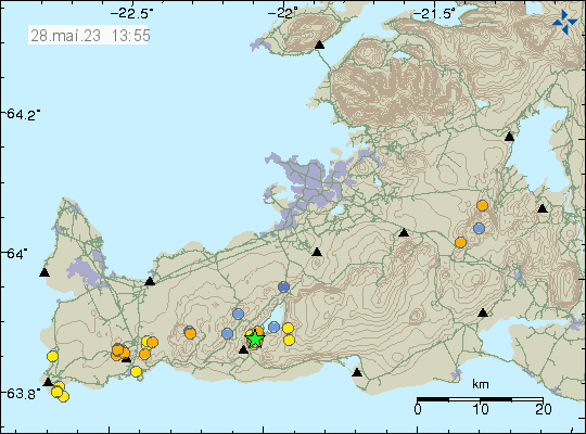
Yesterday (23. May 2023) at 19:22 UTC an earthquake swarm started east of Grímsey island. Largest earthquake had a magnitude of Mw3,8 at the writing of this article. This earthquake swarm is ongoing. The largest earthquake was felt in Akureyri and other nearby towns.
Earthquake activity east of Grímsey island. Copyright of this image belongs to Icelandic Met Office.
Around 130 earthquakes have happened in this earthquake swarm so far. This area of Iceland has frequent earthquake activity. This earthquake swarm might increase, as they sometimes do in this area. It is impossible to know when this activity is going to stop. It took me a little longer to write this article, because this is a frequent earthquake area and I was also trying to get a little break (I also have to do other things outside of this) in next few days from geology. How that goes is to be seen.
I also want to point people out that I have set-up a website that shows Icelandic Met Office harmonic tremor charts and other information for that area.
I also have a webicorder website with an earthquake recording that I run. I am trying to figure out how to install and run seismometer in Iceland again. Its a slow work in progress for me because of the technical problems I am dealing with.
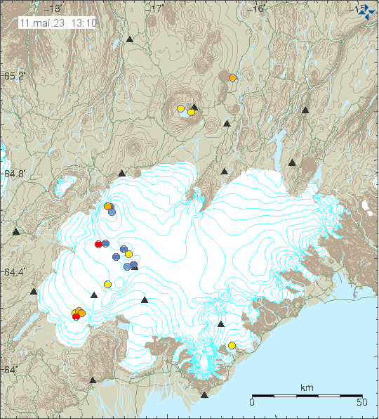
Today (11. May 2023) there was a earthquake swarm in Þórðarhyrna volcano. This are small earthquakes, but their location and depth suggest that this is a dyke intrusion taking place at this location.
Earthquake activity in Þórðarhyrna volcano. Copyright of this image belongs to Icelandic Met Office.
Þórðarhyrna volcano is part of Grímsfjall volcano fissure swarm, that connects to Laki eruption fissures. Last eruption in Þórðarhyrna volcano was in the year 1902 to 1904 and had the VEI=4 according to Global Volcanism Program report that can be read here.
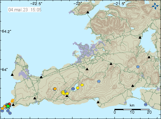
During the night of 4. May 2023 an earthquake swarm took place in the Reykjanes volcano out in the ocean. This was not a large earthquake swarm. Largest earthquake recorded had a magnitude of Mw3,4. Other earthquakes where smaller in magnitude.
Earthquake swarm in Reykjanes volcano. Copyright of this image belongs to Icelandic Met Office.
This earthquake activity suggests an dyke intrusion in this area. This is part of Reykjanes volcano, but that volcano is in part out in the ocean. The Reykjanes volcano has been having regular dyke intrusion in recent years without it resulting in an eruption. That is most likely what is going to happen now.
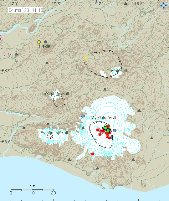
This morning there was a strong earthquake swarm in Katla volcano. At the writing of this article the largest earthquake had a magnitude of Mw4,8 and the second largest earthquake had a magnitude of Mw4,7, the third largest earthquake had a magnitude of Mw4,5. This earthquakes where felt in nearby farms and towns close to Katla volcano. Currently, a lot of smaller earthquakes have happened in Katla volcano.
Earthquake activity in Katla volcano. Copyright of this image belongs to Icelandic Met Office.
There are no changes in harmonic tremor levels at the writing of this article. That makes an eruption unlikely to happen now. That might change later without warning. The air aviation code has been moved to yellow and can be viewed here.
I’ll write a new article if something more happens.
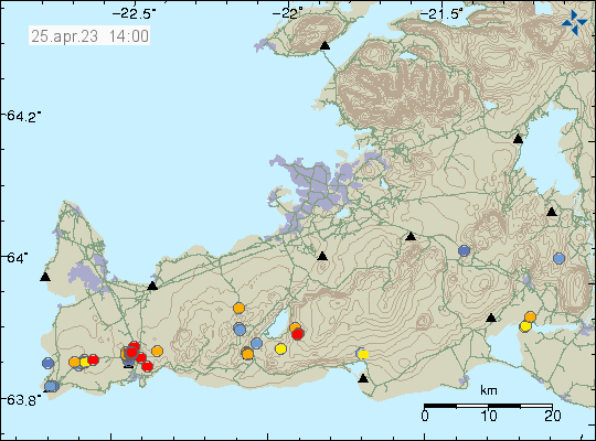
This morning (25. April 2023) an earthquake swarm started north of Grindavík town, next to the Blue Lagoon. This earthquake swarm is ongoing at the writing of this article. If this is going to result in a eruption is impossible to know. The magma has reached the depth of 2 km and that is not good news if this continues to intensify. Large earthquakes do not need to happen before an eruption starts under the correct conditions in the curst and there has been a lot of dyke activity in Reykjanes volcano in last 3 years. Without that activity resulting in a eruption.
Earthquake activity north of Grindavík town. Copyright of this image belongs to Icelandic Met Office.
Eruption at this location would be bad, because of the tourist infrastructure next to this location that is the Blue Lagoon. Only thing that can be done now is to monitor the situation and see if it changes from what is currently happening.
It is possible to view the earthquake swarm in high resolution on Skjálfta-Lísa and other private websites that have similar maps.
Cookie acceptance
We use cookies on our website to give you the most relevant experience by remembering your preferences and repeat visits. By clicking “Accept”, you consent to the use of ALL the cookies.
This website uses cookies to improve your experience while you navigate through the website. Out of these cookies, the cookies that are categorized as necessary are stored on your browser as they are essential for the working of basic functionalities of the website. We also use third-party cookies that help us analyze and understand how you use this website. These cookies will be stored in your browser only with your consent. You also have the option to opt-out of these cookies. But opting out of some of these cookies may have an effect on your browsing experience.
Necessary cookies are absolutely essential for the website to function properly. This category only includes cookies that ensures basic functionalities and security features of the website. These cookies do not store any personal information.
Functional cookies help to perform certain functionalities like sharing the content of the website on social media platforms, collect feedbacks, and other third-party features.
Performance cookies are used to understand and analyze the key performance indexes of the website which helps in delivering a better user experience for the visitors.
Analytical cookies are used to understand how visitors interact with the website. These cookies help provide information on metrics the number of visitors, bounce rate, traffic source, etc.
Advertisement cookies are used to provide visitors with relevant ads and marketing campaigns. These cookies track visitors across websites and collect information to provide customized ads.