Short update Bárðarbunga volcano at 17:52 UTC

This is a short update on current status on Bárðarbunga volcano.

Uncertainty level has been declared on Bárðarbunga volcano and it status has been raised to yellow. There are fluxuation in earthquake activity, this is normal since earthquake activity in volcanoes is never close to constant in this type of situations. There is also a storm taking place in the area at the moment, that is lowering what is detected by the SIL stations that are close to Bárðarbunga volcano.
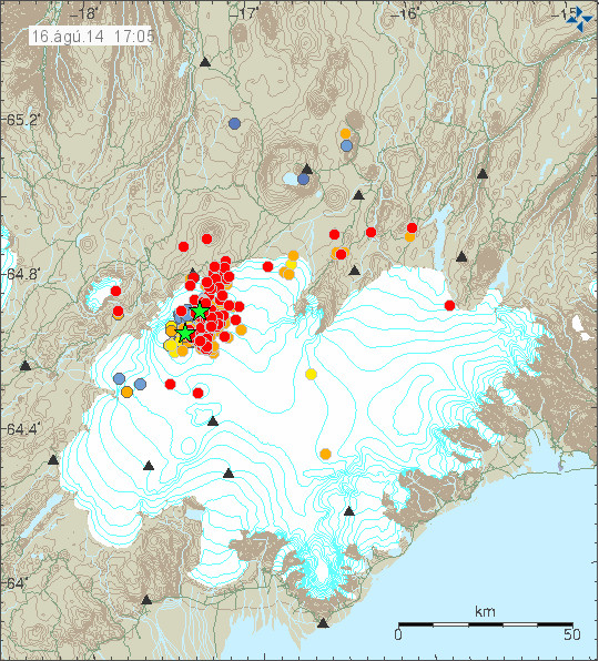
140816_1705
The earthquake activity in Bárðarbunga volcano. Green stars show earthquake larger than magnitude 3,0. Copyright of this image belongs to Icelandic Meteorological Office.

Largest earthquakes recorded so far have the magnitude of 3,1 and 3,5. There is a chance that more magnitude 3,0 have taken place but have not been reviewed yet by geologist at Icelandic Meteorological Office due the amount of earthquakes taking place at the moment.

140816_1710_trace
As can be seen here the earthquake swarm is dense. Copyright of this image belongs to Icelandic Meteorological Office.
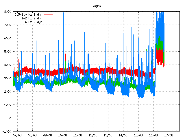
dyn.svd.16.08.2014.17.12.utc
Harmonic tremor in Dyngjuháls SIL station. It has been dropping in the past few hours. Copyright of this image belongs to Icelandic Meteorological Office.
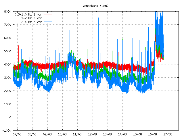
von.svd.16.08.2014.17.12.utc
Harmonic tremor in Vonarskarð SIL station. The drop in harmonic tremor also appears clearly here. Copyright of this image belongs to Icelandic Meteorological Office.
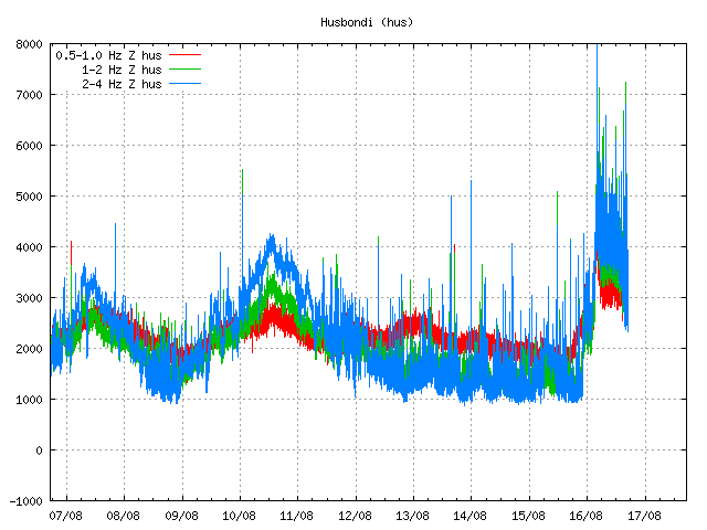
hus.svd.16.08.2014.17.13.utc
Harmonic tremor in Húsbóndi SIL station. The drop in harmonic tremor also appears here clearly. Copyright of this image belongs to Icelandic Meteorological Office.

In the past few hours the harmonic tremors around Bárðarbunga volcano have been dropping slowly. The drop in harmonic tremor has not been followed by drop in earthquake activity. At least that is not the case when this is written. This means that the magma that is on the move there still has not yet found a pathway to the surface, even if some small part of it has done so in possibly in one or two eruptions vents under the thick glacier. If the harmonic tremor stops completely without the earthquake activity stopping it means that magma is still on the move there and it might look for a new pathway to the surface. When and where that might happen is impossible to know at current time, but once the magma has clear path to the surface, even if it is under a glacier all earthquake activity is going to stop (for most part).

I am going to post more information when more details are available.

Unconfirmed eruption in Bárðarbunga volcano

This information is going to get outdated quickly as more information is collected on this activity.

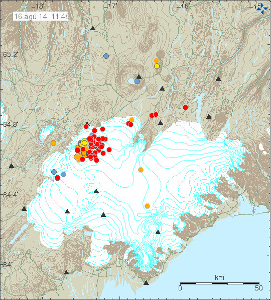
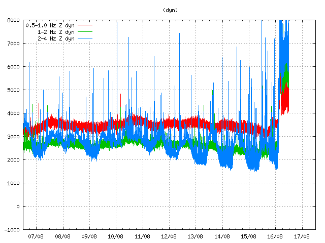
During all last week (Week 33) there has been a minor earthquake swarm in Bárðarbunga volcano. No other activity followed this minor earthquake activity during the week until last night (16-August-2014). During the night (around 02:20 UTC) a harmonic tremor started to appear on SIL stations around Bárðarbunga volcano. Following the appearance of the harmonic tremor earthquake activity started around 03:30 UTC. Largest earthquakes in this swarm have magnitude around 3,0 so far. Depth is around 5 to 10 km. During the night the earthquake swarm moved around in the volcano and is now more east then it first started. According to Rúv news the glacier around this part of Vatnajökull glacier is around 700 meters thick, so it going to take a major eruption to break the ice. This however also means that when a glacier flood starts in this area there is a high risk that is going to be large.

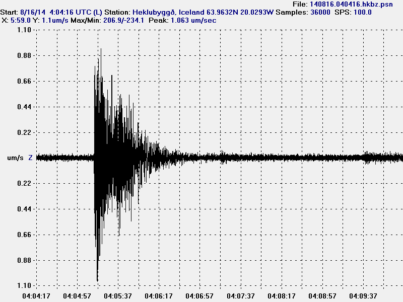
140816.040416.hkbz.psn
The largest earthquake that I did record during the night. This image is released under CC Licence. Please see CC Licence page for more details.

140816_1145
The earthquake swarm in Bárðarbunga volcano at 11:45 UTC. Copyright of this image belongs to Icelandic Meteorological Office.

dyn.svd.16.08.2014.12.01.utc
Harmonic tremor on Dyngjuháls SIL station. This SIL stations is closest to the area of activity in Bárðarbunga volcano. Copyright of this image belongs to Icelandic Meteorological Office.

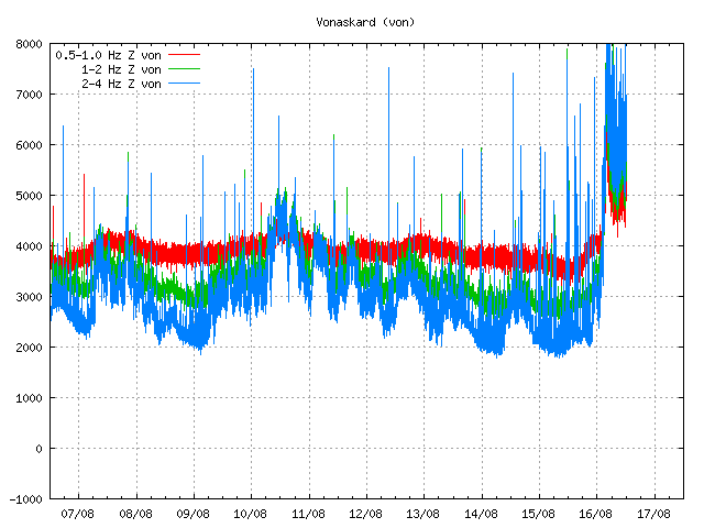
von.svd.16.08.2014.12.02.utc
Harmonic tremor on Vonaskarð SIL station. This is one of the SIL station that is closest to the area of activity in Bárðarbunga volcano. Copyright of this image belongs to Icelandic Meteorological Office.

Currently the activity in Bárðabunga volcano is not stable, it does fluctuate a little. Besides this minor fluctuation it seems stable. Based on harmonic tremor signal and its range this does not appear to be a large eruption so far. That might change without warning. I do however expect larger earthquakes before any major volcano eruption in Bárðarbunga volcano. What seems to have happened is that a dike intrusion got to the surface and started this eruption, even if it is just small one at current time.

I am going to post update soon as more information gets available. This situation is going to change quickly and without much warning.

Earthquake swarm in Katla volcano

Few days ago the uncertainty level around glacier rivers that come from Mýrdalsjökull glacier have been cancelled. However the area remains dangerous due to gases that might collect in pockets in low lying areas. So it is not safe to go close to the glacier rivers from Mýrdalsjökull glacier even if the uncertainty level has been cancelled by the authorities.

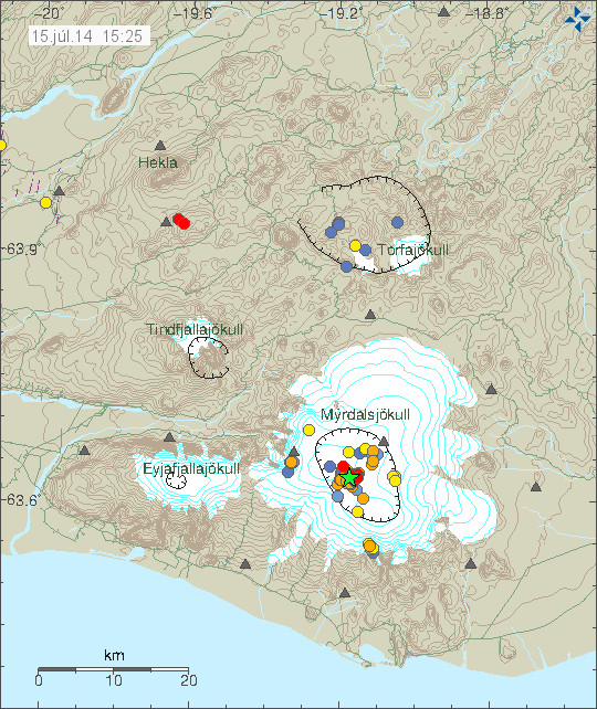
140715_1525
Earthquake activity today in Katla volcano. Copyright of this image belongs to Icelandic Meteorological Office.

Today (15-July-2014) an earthquake swarm took place in Katla volcano. Largest earthquake in this swarm had the magnitude of 3,1. Other earthquake that happened where smaller. This earthquake swarm is one of the most dense in the past few weeks and it appears that earthquake activity is once again on the rise in Katla volcano. I am now expecting this earthquake activity to continue. I also think there is a high risk of small eruptions within the Katla volcano caldera. This eruptions would only last for few hours at the most and not even break trough the Mýrdalsjökull glacier. It has to be noted that scientist on duty at Icelandic Meteorology Office does not agree with my opinion. While there is a high risk of this (in my opinion) that this might happen, it does not mean it is going to do so. The best thing that can be done for now is to observe activity in Katla volcano.

If anything more happens. I am going to post update on it soon as possible. Any large earthquakes that happen in Katla volcano do appear clearly on my geophone at Heklubyggð and they can be viewed here. There is also a web camera of Katla / Eyjafjallajökull located here.

Lower conductivity detected in glacier rivers from Mýrdalsjökull glacier (Katla volcano)

Today (12-July-2014) it was reported in the news that conductivity in rivers coming from Mýrdalsjökull glacier are showing signs of less conductivity and lower water levels. There is still an uncertainty level in effects around this area, since level of dissolved gases from the rivers remains at close to dangerous levels at current time.

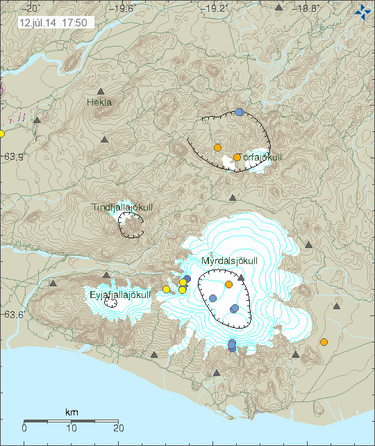
140712_1750
Lower earthquake activity in Katla volcano. Copyright of this image belongs to Icelandic Meteorological Office.

Earthquake activity in Katla volcano has dropped below background levels. So there is now less activity taking place in Katla volcano as is, if this quiet is going to remain is impossible to know at current time. This low earthquake activity might change without warning, since that has happened in the past (observed in the past few years).

If anything changes I am going to post update about it soon as possible.

Other: In December-2014 I am going to move back to Iceland. Why that is can be read here (in English).

Donations: Please remember to support my work and keep me from being broke. Thanks for the support.

Uncertainty level declared at Katla volcano

Today (8-July-2014) a uncertainty level was declared at Katla volcano. This means that people should be aware of the activity that is now taking place in Katla volcano. The most dangerous areas at the moment are the glacier rivers that come from Katla volcano, due the extremely dangerous gases that are in the water coming from Mýrdalsjökull glacier. People should not stop at Múlakvísl glacier river and other glacier rivers that come from Mýrdalsjökull glacier due to this danger. It is also unclear if an larger glacier flood might take place, if it does it is going to happen with no warning at all. Tourist in the area also urged to have there mobile phones turned on in case emergency SMS needs to be sent to people in the area around Mýrdalsjökull glacier.

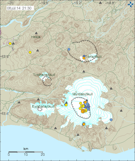
140708_2130
Earthquake activity in Katla volcano during the past 24 hours. Copyright of this image belongs to Icelandic Meteorological Office.

Currently [when I write this text] there is little earthquake activity in Katla volcano. That calm might not last, since earthquake activity has had the pattern of dropping off for few hours between peaks in activity. The largest earthquake during the past 24 hours had the magnitude of 3,0. Smaller earthquakes had the magnitude of 2,7 and lower magnitudes.

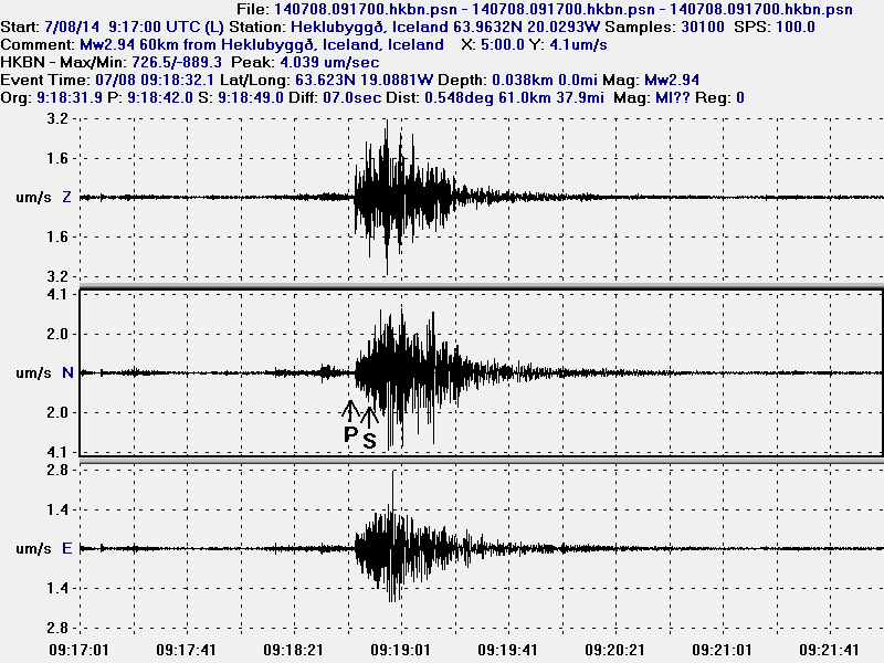
140708.091700.hkbz.psn
The magnitude 3,0 earthquake in Katla volcano this morning at 09:18 UTC. This image is released under Creative Commons licence. Please see CC Licence page for more details.

Earthquake activity has been in the same pattern as did happen in July-2011. So far no harmonic tremor has been detected. It is impossible to know if this is going to result in a eruption or not. The risk of an eruption is higher now then normal, but that does not mean that a eruption is going to take place. It is possible to see larger earthquakes from Katla volcano here on my webicorder website. It is possible to see Katla volcano here if it is not too cloudy.

Donations: Please remember to donate to support my work or buy from Amazon (select your Amazon store before you buy). I am getting awfully broke already (I am just on minimal income from Iceland and that is no good). Thanks for the support.

Earthquake swarm in Grímsfjall volcano

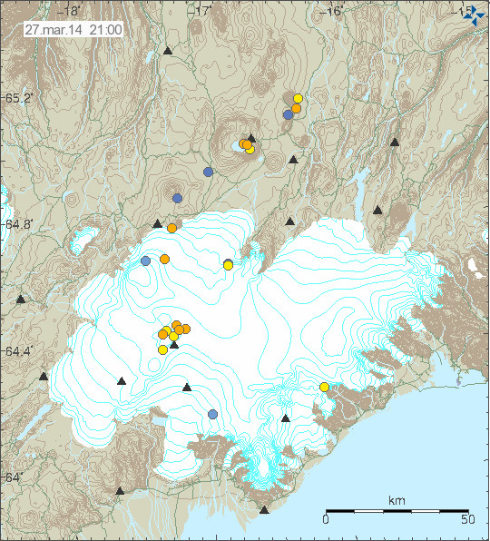
Today (27-March-2014) an earthquake swarm took place in Grímsfjall volcano. This activity is connected to current minor glacier flood from Grímsvötn glacier lake that is now taking place. The glacier flood it self is an minor and is about the same size as an glacier flood from Grímsvötn glacier lake in November-2012.

140327_2100
Earthquake activity in Grímsfjall volcano today (27-March-2014). Copyright of this image belongs to Icelandic Meteorological Office.

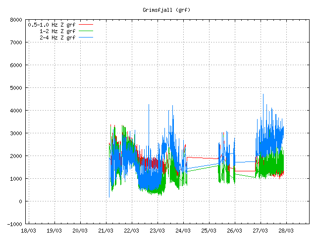
Harmonic tremor has been increasing in Grímsfjall volcano following this glacier flood. The leading idea is that the glacier flood is creating this high frequency harmonic tremors. This idea however remains unconfirmed at current time.

grf.svd.27.03.2014.21.13.utc
Harmonic tremor at 21:13 UTC on 27-March-2013 at Grímsfjall volcano. The harmonic tremor starts at the end of this plot. Copyright of this image belongs to Icelandic Meteorological Office.

grf.svd.27.03.2014.22.55.utc
Harmonic tremor at 22:55 UTC on 27-March-2014. As can be seen the high (blue line) harmonic tremor is increasing at the moment. Copyright of this image belongs to Icelandic Meteorological Office.

At present time there is nothing to suggest that an eruption has or is about to start in Grímsfjall volcano. However Grímsfjall volcano is unpredictable and highly active when it comes to eruptions. If an eruption starts in Grímsfjall volcano it might do so without an warning. Earthquake activity in Grímsfjall volcano would increase sharply just before the eruption would start as was the case before the eruption in 2011 (covered here). More detailed monitoring can of Grímsfjall volcano and other volcanoes in Vatnajökull glacier can be found here (Icelandic).

Advertisement: As I did say few days ago. I am adding advertisement back to my websites. Since I need to eat and pay the bills. There however has been a minor issue with my Google Adsense account. An issue that has so far not yet been resolved by Google. Once its resolved I am going to go trough the process of getting my account approved again. I was too detailed back in January when I closed down my Google Adsense account. I hope to have advertisements back before some volcano erupts in Iceland.

Increasing conductivity in Skeiðará glacier river (Grímsfjall volcano)

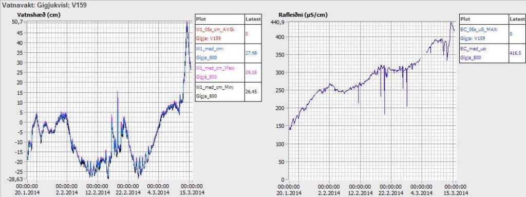
Since 20-January-2014 there has been increase in conductivity in Skeiðará glacier river that comes from Vatnajökull glacier. The reason for this change is that water is leaking from Grímsfjall volcano. Water levels have also been increasing and dropping during this time since this started.

gigjukvisl.svd.14.03.2014.vedur.is
The conductivity in Skeiðará glacier river from 20-January-2014. Picture from Icelandic Meteorological Office Facebook page. Copyright of this image belongs to Icelandic Meteorological Office.

Conductivity is now measured at 416 µS/cm and according to Icelandic Meteorological Office that is an high value coming from Grímsfjall volcano. This water also goes trough several lakes and before it reaches the sensor at Gígjukvísl bride. So at the source of Skeiðará glacier river this value is probably even higher. No major earthquake activity and no harmonic tremor activity has taken place following this water leak from Grímsvötnum glacier lakes. But it appears that some glacier quakes might be taking place at the moment. Such activity can be seen here on IMO website. Currently the volume of water in Grímsvötn glacier lakes is small since the eruption that took place in Grímsfjall volcano in the year 2011. Coverage of that eruption can be found here. At current time nothing more is expected to happen.

Donation notice: Please remember to support my work with donation. Otherwise I am going to have really bad month of March-2014 food wise. Thanks for the support.

Waiting for the eastern Skaftá glacier cauldron

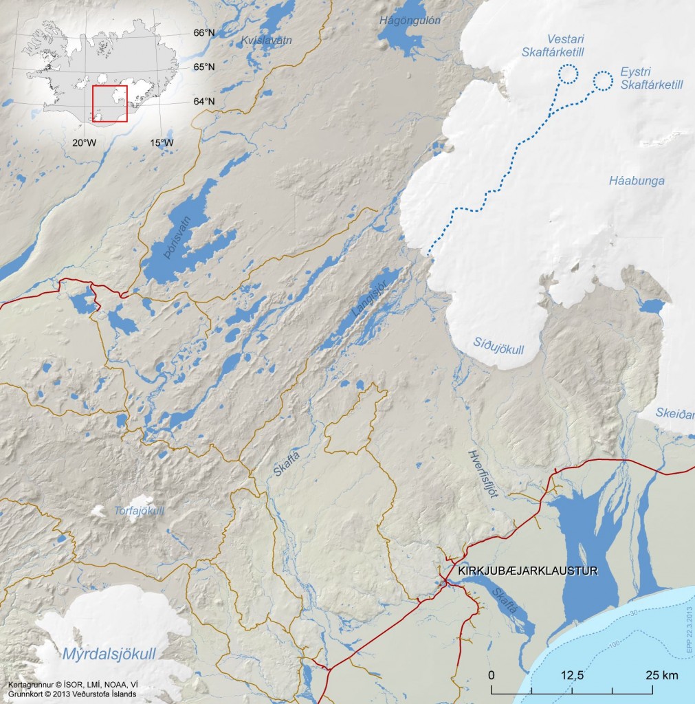
The glacier flood in Skaftá glacier river is almost over or is over at present time (21-January-2014). This however does not mean that everything is over. Since there are two cauldrons in the Vatnajökull glacier in the Hamarinn volcano it means there is more water stored there now then has now flooded from the glacier. It is now clear that the eastern Skaftá glacier cauldron in Vatnajökull glacier has not emptied it self in this flood from the western Skaftá glacier cauldron.

skaftarkatlar.svd.19-Januar-2014
The eastern (Eystri) and western (Vestari) cauldrons in Vatnajökull glacier. Copyright of this image belongs to Icelandic Meteorological Office.

When the eastern glacier cauldron empties it self they are expecting a lot larger glacier flood to take place. Since there is a lot more water holding up in the eastern Skaftá glacier cauldron. It is also longer since it flooded and emptied it self. Last glacier flood from the eastern Skaftá glacier cauldron was in the year 2010. More information on how this flood system works can be found here (in Icelandic) on Icelandic university website geology department.

Glacier flood started in Skaftár glacier river

It was announced today (19-January-2014) that glacier flood has started in Skaftá glacier river (or connected rivers) from Skjaftár cauldrons in Vatnajökull glacier. Currently the water is discharging from Skaftár cauldrons at the rate of 370 m3/s according to Icelandic Meteorological Office. So far no changes have taken place in harmonic tremors close to Hamarinn volcano where the Skaftár cauldrons lie within Vatnajökull glacier.

Smell of hydrogen sulphide has been detected by people living close the rivers that the glacier flood is discharging into. There is a considerable risk of poisoning if people get to close the rivers that hold the flood water. It is currently believed that it is the western Skaftár cauldron that is now emptying, that one did empty it self back the in the year 2012. That is however not going to be confirmed until the area can be checked by flying over it and see what is taking place at this location. That might take few days since it is dependent on weather when it is possible to do such flight.

skaftarkatlar.svd.19-Januar-2014
Location of Skaftár cauldrons in Vatnajökull glacier. Copyright of this image belongs to Icelandic Meteorological Office. Picture is taken from Icelandic Meteorological Office Facebook page.

skaftarkaltar.rennsli.svd.19-Januar-2014
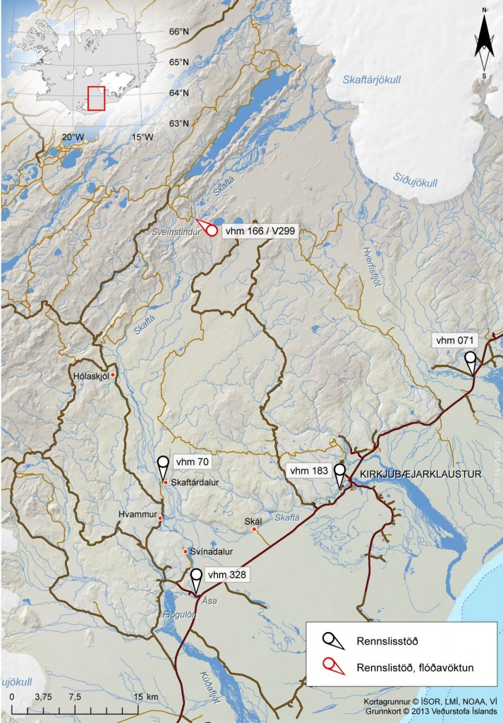
The current flood in Skaftár glacier river. The water monitoring stations around Vatnajökull glacier. Red stations are monitored for floods, black ones are normal flow stations. Copyright of this image belongs to Icelandic Meteorological Office. Picture is taken from Icelandic Meteorological Office Facebook page.

Uncertainty level has been declared in the area do to this glacier flood by the Civil Protection and Emergency Management in Iceland. It is advised against people travelling in the area while this glacier flood takes place. On Vatnajökull glacier there is also a risk of new cracks forming in the glacier was the cauldron is emptied of water in the next few days. This cracks are dangerous and really deep and wide on the top, but get narrower closer to the end of them. It is possible to monitor the glacier flood here on Icelandic Meteorological Office website.

Icelandic news about this. Some English text is in some of the news. It is possible to use Google Translate on this, but result can be unreliable.

Skaftárhlaup er mjög líklega hafið (Rúv.is, maps, English text)
Skaftárhlaup hafið en það vex óvenju hægt (Rúv.is, Icelandic, maps)
Óvissustig vegna Skaftárhlaups (Rúv.is, Icelandic, maps)

Skaftárhlaup er hafið (mbl.is, English text)
Óvissustig vegna Skaftárhlaups (mbl.is, Icelandic)
Fundað um næstu skref (mbl.is, Icelandic)

Post updated at 20:34 UTC on 19-January-2014.

Increased conductivity continues in Múlakvísl glacier river (Katla volcano)

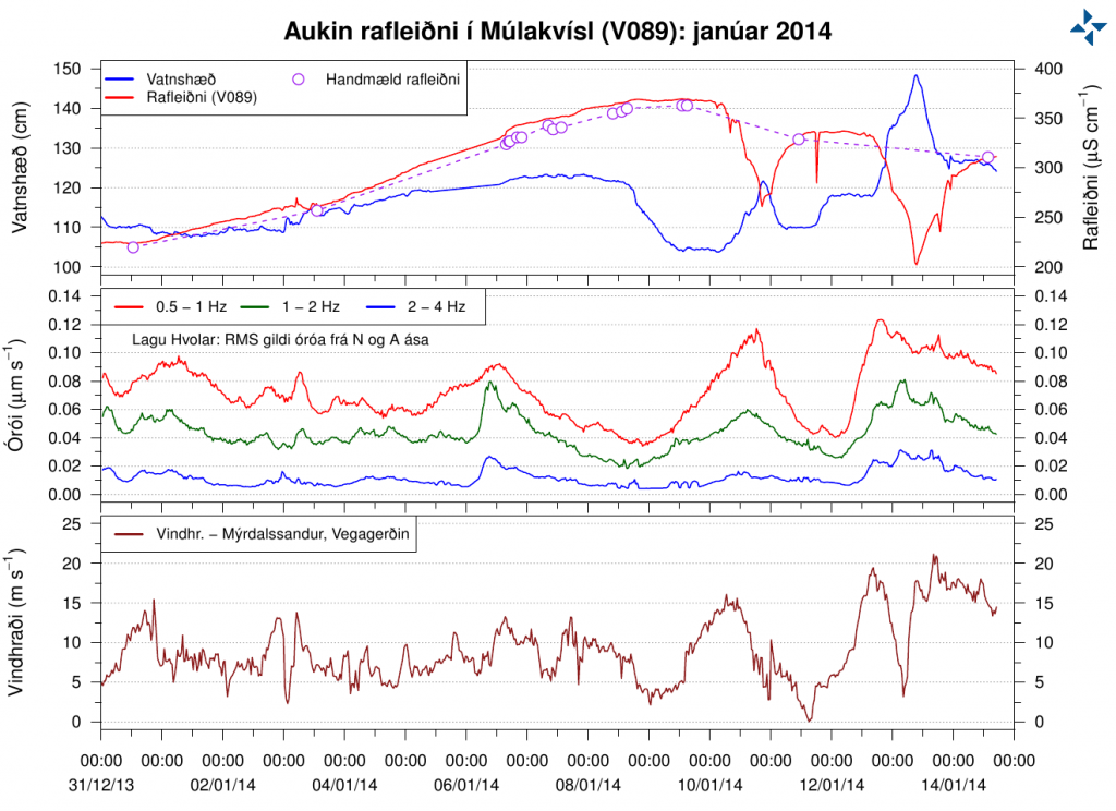
Last week I wrote about increased conductivity in Múlakvísl glacier river that comes from Mýrdalsjökull glacier (Katla volcano). This trend has continued into second week with the conductivity. The conductivity in Múlakvísl is now on the range of ~327 to ~360 µS/cm. There has also been a slight increase in water levels following this change in Múlakvísl glacier river. Normal value for this time of year according to Icelandic Meteorological Office is ~180 µS/cm in Múlakvísl glacier river. Since 31-December-2013 the conductivity in Múlakvísl glacier river has always been over 220 µS/cm.

rafleidni.mulakvisl.januar.1-15.2014
Conductivity in Múlakvísl glacier river. Top: conductivity. Middle: Harmonic tremor. Bottom: Windspeed. Copyright of this image belongs to Icelandic Meteorological Office.

mulakvisl_animated
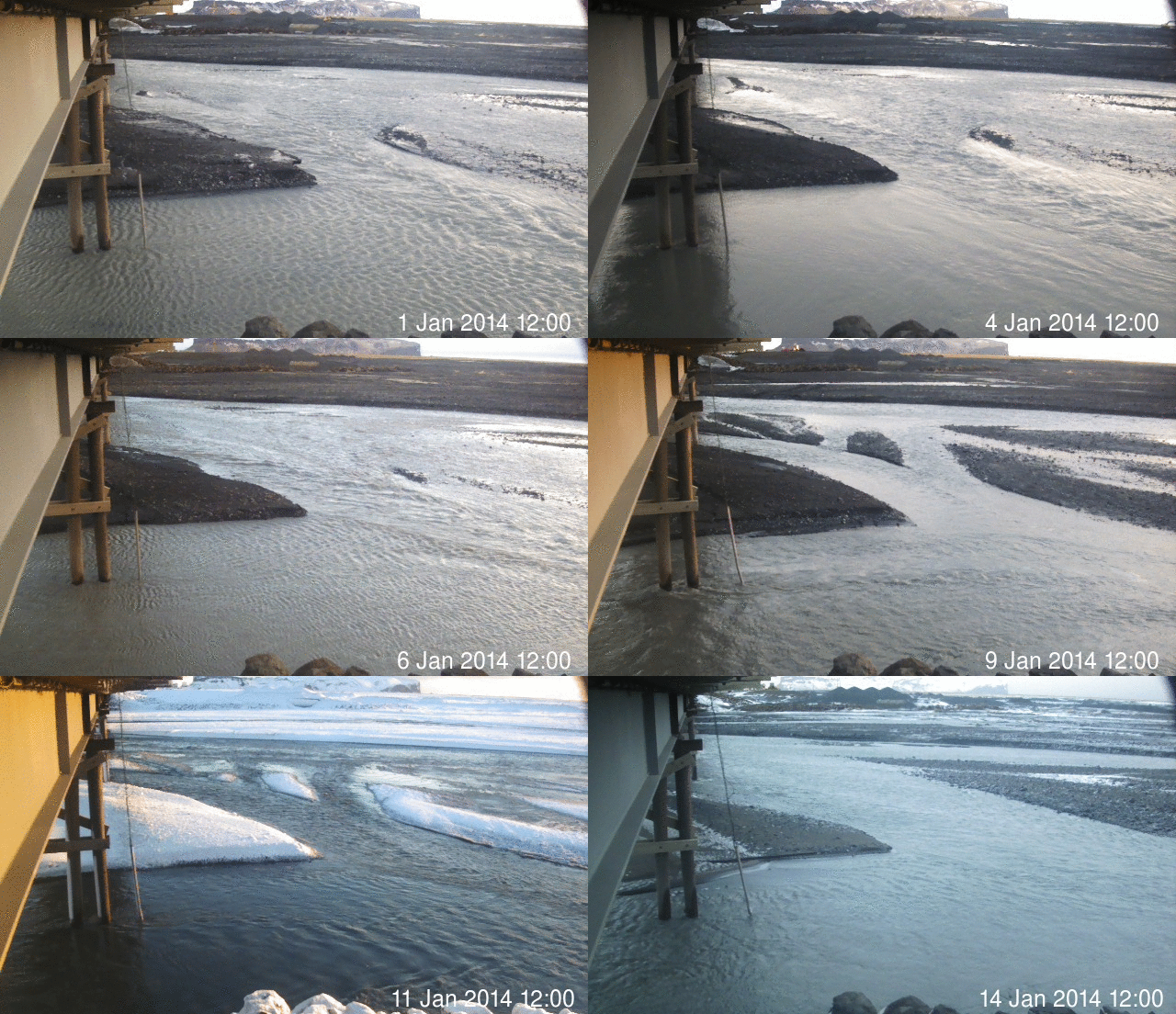
Animated image from Icelandic Meteorological Office showing changes in Múlakvísl glacier river during this time period. Original image can be found here. Copyright of this image belongs to Icelandic Meteorological Office.

No harmonic tremors or earthquakes have been detected (besides normal activity) following this changes. What is taking place is that a cauldron in Mýrdalsjökull glacier is now leaking melt water that has been built up due to hydrothermal (hot springs) activity under the glacier. So far it does not appear that current changes in Múlakvísl glacier river mean anything at all. If that is going to change is impossible to know at this point.

Icelandic News about this

Rafleiðni há en enginn órói mælist (mbl.is)

Donation notice: Please remember to support me so that I can continue to report on volcano and earthquake activity in Iceland.

Post updated at 19:09 UTC on 15-January-2014.
Post updated at 20:49 UTC on 15-January-2014.