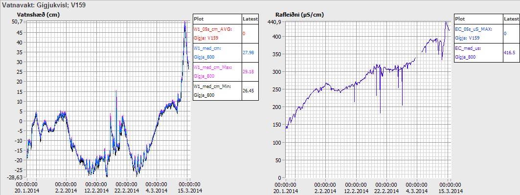
Glacier flood started in Skaftár glacier river

It was announced today (19-January-2014) that glacier flood has started in Skaftá glacier river (or connected rivers) from Skjaftár cauldrons in Vatnajökull glacier. Currently the water is discharging from Skaftár cauldrons at the rate of 370 m3/s according to Icelandic Meteorological Office. So far no changes have taken place in harmonic tremors close to Hamarinn volcano where the Skaftár cauldrons lie within Vatnajökull glacier.

Smell of hydrogen sulphide has been detected by people living close the rivers that the glacier flood is discharging into. There is a considerable risk of poisoning if people get to close the rivers that hold the flood water. It is currently believed that it is the western Skaftár cauldron that is now emptying, that one did empty it self back the in the year 2012. That is however not going to be confirmed until the area can be checked by flying over it and see what is taking place at this location. That might take few days since it is dependent on weather when it is possible to do such flight.

skaftarkatlar.svd.19-Januar-2014
Location of Skaftár cauldrons in Vatnajökull glacier. Copyright of this image belongs to Icelandic Meteorological Office. Picture is taken from Icelandic Meteorological Office Facebook page.

skaftarkaltar.rennsli.svd.19-Januar-2014
The current flood in Skaftár glacier river. The water monitoring stations around Vatnajökull glacier. Red stations are monitored for floods, black ones are normal flow stations. Copyright of this image belongs to Icelandic Meteorological Office. Picture is taken from Icelandic Meteorological Office Facebook page.

Uncertainty level has been declared in the area do to this glacier flood by the Civil Protection and Emergency Management in Iceland. It is advised against people travelling in the area while this glacier flood takes place. On Vatnajökull glacier there is also a risk of new cracks forming in the glacier was the cauldron is emptied of water in the next few days. This cracks are dangerous and really deep and wide on the top, but get narrower closer to the end of them. It is possible to monitor the glacier flood here on Icelandic Meteorological Office website.

Icelandic news about this. Some English text is in some of the news. It is possible to use Google Translate on this, but result can be unreliable.

Skaftárhlaup er mjög líklega hafið (Rúv.is, maps, English text)
Skaftárhlaup hafið en það vex óvenju hægt (Rúv.is, Icelandic, maps)
Óvissustig vegna Skaftárhlaups (Rúv.is, Icelandic, maps)

Skaftárhlaup er hafið (mbl.is, English text)
Óvissustig vegna Skaftárhlaups (mbl.is, Icelandic)
Fundað um næstu skref (mbl.is, Icelandic)

Post updated at 20:34 UTC on 19-January-2014.

Increased conductivity continues in Múlakvísl glacier river (Katla volcano)

Last week I wrote about increased conductivity in Múlakvísl glacier river that comes from Mýrdalsjökull glacier (Katla volcano). This trend has continued into second week with the conductivity. The conductivity in Múlakvísl is now on the range of ~327 to ~360 µS/cm. There has also been a slight increase in water levels following this change in Múlakvísl glacier river. Normal value for this time of year according to Icelandic Meteorological Office is ~180 µS/cm in Múlakvísl glacier river. Since 31-December-2013 the conductivity in Múlakvísl glacier river has always been over 220 µS/cm.

rafleidni.mulakvisl.januar.1-15.2014
Conductivity in Múlakvísl glacier river. Top: conductivity. Middle: Harmonic tremor. Bottom: Windspeed. Copyright of this image belongs to Icelandic Meteorological Office.

mulakvisl_animated
Animated image from Icelandic Meteorological Office showing changes in Múlakvísl glacier river during this time period. Original image can be found here. Copyright of this image belongs to Icelandic Meteorological Office.

No harmonic tremors or earthquakes have been detected (besides normal activity) following this changes. What is taking place is that a cauldron in Mýrdalsjökull glacier is now leaking melt water that has been built up due to hydrothermal (hot springs) activity under the glacier. So far it does not appear that current changes in Múlakvísl glacier river mean anything at all. If that is going to change is impossible to know at this point.

Icelandic News about this

Rafleiðni há en enginn órói mælist (mbl.is)

Donation notice: Please remember to support me so that I can continue to report on volcano and earthquake activity in Iceland.

Post updated at 19:09 UTC on 15-January-2014.
Post updated at 20:49 UTC on 15-January-2014.

Increased conductivity in Múlakvísl glacier river

Donation notice: If you like my work. Please consider donating to help me continue my work. This site is now advertisement free as explained here. Donation button is going to be added soon. If you want to donate regularly, please use the Paypal button on the sidebar to do so. Information on how to donate to me with other ways can be found here. Thanks!

It has been reported in Icelandic media today that there is an increased conductivity in Múlakvísl glacier river that comes from Mýdalsjökull glacier. This increased conductivity started in Múlakvísl on 31-December-2013 and has lasted until today (it might last for few days longer).

Mýrdalsjökull glacier is on top of Katla volcano. There are no signs of increased activity following this and according to the news this is most likely a cauldron under the glacier empting it self of water melted by hydrothermal area under the glacier. So far there is no risk to this increased conductivity in Múlakvísl glacier river.

There are no signs of glacier flood is about to take place, at least it is not going to a large one if it happens. That is the current idea at the moment anyway. No earthquake activity or tremor activity has taken place following this changes in Múlakvísl glacier river.

Icelandic News about this

Aukin rafleiðni en ekki útlit fyrir hlaup (Rúv.is)
Fylgjast vel með Múlakvísl (mbl.is)
Vaxandi rafleiðni í Múlakvísl (Vísir.is)

Earthquake swarm in Hveravellir

During the night of 6-January-2014 an earthquake swarm started in Langjökull volcano, the northern one. The nearby area is known as Hveravellir geothermal area. So far this has just been a minor earthquake swarm. With largest earthquakes not exceeding magnitude 2,0 at the moment.

140106_2150
The earthquake swarm in Hveravellir geothermal area. Copyright of this image belongs to Icelandic Meteorological Office.

The tremor plot of nearby SIL station shows that more earthquake activity is taking place then appears on Icelandic Meteorological Office website. This are then earthquake that are too small to be detected by other nearby SIL stations.

hve.svd.06-Januar-2014.22.01.utc
The earthquake activity at Hveravellir SIL station. Copyright of this image belongs to Icelandic Meteorological Office.

I do expect this earthquake activity to continue for some time now. It is impossible to know for sure if this activity is going to increase or not.

Earthquake activity in Esjufjöll and Kverkfjöll volcanoes

Earthquake activity started again in Esjufjöll volcano today (20-Desember-2013). The largest earthquake had the magnitude of 2,9 and had the depth of 5,0 km. So far only two earthquakes have been recorded, but it is not uncommon that earthquake activity in Esjufjöll volcano starts slow before it picks up. Earthquake activity remains low in Esjufjöll volcano, but there is now more earthquake activity in Esjufjöll volcano for the past few years then in past several decades (perhaps, recording is missing in the past)

Kverkfjöll volcano

Earthquake activity continued in Kverkfjöll volcano today. None of the earthquake did reach the magnitude of 3,0. The largest earthquake had the magnitude of 2,0 and the depth of 5,3 km.

131220_1910
Earthquake activity in Esjufjöll volcano and Kverkfjöll volcano. Copyright of this image belongs to Icelandic Meteorological Office.

I am expecting more earthquake activity in Kverkfjöll volcano. But I expect it to remain small as it currently is at least I do not expect any earthquake above the magnitude of 3,0 to take place as is.

Fossil of a tree found in road tunnel work

A long time a volcano erupted in Iceland. This volcano spewed out basalt lava field (Hawaii style). This lava did flow over a forest that was nearby and killing all the trees in it. Few weeks ago and several million years later and few kilometres down the remains of this forest was found. Since one of the tree did fossilize in the lava. As the tree was engulfed in the lava it did turn to charcoal that was later removed by water and leaving the empty imprint of the tree in the bedrock.

The remains of the tree are now clearly visible in the road construction tunnel. The hole after the tree is full of water and part of it has been removed by the tunnel digging. Picture of it along with news can be found in the link below.

Fossil of a tree found in tunnel construction

Far eftir trjábol í Vaðlaheiðargöngum (Rúv.is, Icelandic, Picture)

Magnitude 3,1 earthquake in Kverkfjöll volcano

Today (19-Desember-2013) at 09:30 UTC a magnitude 3,1 earthquake took place in Kverkfjöll volcano. The depth of this earthquake was 5,0 km. No aftershocks have been recorded following this earthquake.

131219_1415
The magnitude 3,1 earthquake in Kverkfjöll volcano. Copyright of this image belongs to Icelandic Meteorological Office.

This is the first activity in Kverkfjöll volcano for some time now. But overall activity has been slowly increasing in Kverkfjöll volcano for the past few years. So far however there is nothing to suggest that volcano eruption is going to take place in near future.

Update 1: Three aftershocks took place in Kverkfjöllum volcano. The largest one had the magnitude of 1,7. The other two earthquakes had the magnitude of 1,3 and 1,5. With the depth of 6,5 km to 3,4 km.

131219_1615
The aftershocks in Kverkfjöll volcano. Copyright of this image belongs to Icelandic Meteorological Office.

It is possible that more aftershocks are going to take place in Kverkfjöll volcano in next few hours to days.

Blog post updated at 16:37 UTC.

Earthquake swarm in Hengill volcano

A earthquake swarm of minor earthquakes took place in Hengill volcano today. This earthquake swarm was due to Orkuveita Reykjavíkur was pumping down water in the area.

131214_1815
The earthquake swarm in Hengill volcano this evening. Copyright of this image belongs to Icelandic Meteorological Office.

The largest earthquake had the magnitude of 1,4. Other earthquakes were smaller.

Continued earthquake activity north of Kolbeinsey Island

During the week the earthquake activity continued north of Kolbeinsey Island. Two more earthquakes appeared, they had the magnitude of 3,0 and 3,1 according to EMSC. I do not have any image of that activity since I was travelling the days it was on Icelandic Meteorological Office website.

Webicorder images still do not update

Something failed in my hardware few days ago so no webicorder images are updating at the moment. I do not know what did go wrong or what did fail and it is going to be few weeks until I know why. According to electronic usage readings from my home something powered down or was powered down (I know what normal usage should be based on what electronics where turned on when I left). I am not sure what was turned off or did go offline and I won’t find out until I get back home. Until then my webicorder images are not going to be updated. International webicorders are updating (mostly) normal now and all large earthquake activity in the world is going to appear on that website. I do not run any of the images shown there so they are unaffected by this failure.

Donations

Like so many projects on the internet. I depend on donations to keep my working ongoing here. They allow me to work on this full time. Since I am not allowed to use the “Donate” button from Paypal. People have send me the donation directly via “Send Money” option on Paypal website. Thanks for the support.

Earthquake swarm activity north of Kolbeinsey island

Donation note: I want to thank people for the donations I have received over the year. But donations allow me to continue my work here and keep writing about volcano and earthquake activity in Iceland. If not for donations I would not be able to do anything. That includes writing on this website. So I am always thankful for donations. Since they allow me to continue my work here. Donations also allow me to maintain my geophone network in Iceland is expensive and last hardware updates was exactly that. So if you can donate, it is most welcomed. Information on how to donate can be found here. Thanks for the support.

During the night a magnitude 4,1 earthquake was recorded around 240 km north of Kolbeinsey island. This is automatic location and magnitude. So it is subject to change.

131210_0940
Earthquake activity north of Kolbeinsey island (green star). Copyright of this image belongs to Icelandic Meteorological Office.

I don’t know yet if I detected it on my Böðvarshólars geophone (website here). Since I have not had the change to review the data from that geophone yet. I am not sure what is taking place at that location. This might be earthquake swarm activity before and eruption starts there, but due to remote location and ocean depth it is currently impossible to know for sure at this point.

Minor earthquake swarm in Esjufjöll volcano

Today (27-November-2013) an minor earthquake swarm took place in Esjufjöll volcano. This earthquake swarm was just three earthquakes according to Icelandic Meteorological Office website. There is a chance of more earthquakes not being detected due to bad weather in this area at the moment.

131127_2225
The three earthquakes in Esjufjöll volcano. Copyright of this image belongs to Icelandic Meteorological Office.

The largest earthquake in this minor earthquake swarm had the magnitude of 1,8 and had the depth of 4,5 km. Last eruption in Esjufjöll volcano was possibly in the year 1927, but it is not confirmed according to Global Volcanism Program.