Ongoing earthquake activity in Öræfajökull volcano, fresh earthquake activity in Tungnafellsjökull volcano

At the moment the earthquake activity that started in Öræfajökull volcano on 25-February-2018 is currently ongoing. Most of the earthquakes happening are small, most are smaller than magnitude 1,0.


Earthquake activity in Öræfajökull and Tungnafellsjökull volcanoes. Copyright of this image belongs to Icelandic Met Office.

Tungnafellsjökull volcano

Directly north-west of Öræfajökull volcano is a another volcano making earthquakes. That volcano is named Tungnafellsjökull volcano. Most of its earthquake activity is also small earthquakes with magnitude smaller than 1,0. After the eruption in Bárðarbunga volcano 2014 – 2015 earthquake activity increased in Tungnafellsjökull volcano. Earthquake activity was also high during the eruption in Bárðarbunga volcano due to stress changes in the crust. It is likely that current earthquake activity is due to adjustment of tectonic stresses.

Donations

Please remember to support my work with donations. Currently I am broke due to how bills work here in Denmark. I am moving to Iceland by the end of May and that is going to resolve this issue but until that happens I am stuck with the problem of being broke. Thanks for the support. 🙂

Dyke intrusion south-east of Bárðarbunga volcano

On Sunday (21-January-2018) a dyke intrusion took place south-east of Bárðarbunga volcano. The area is question is slightly outside of Bárðarbunga volcano fissure swarm but seems to be connected to the main volcano.


The earthquakes south-east of Bárðarbunga volcano. Copyright of this image belongs to Icelandic Met Office.

Largest earthquake only had magnitude 1,2 and the shallowest depth was only 13,9 km with a magnitude 0,8 earthquake. The risk of an eruption in this area is increasing, but it is not possible to know when a eruption might happen. This area has been active for some time now with regular dyke intrusions at the same location.

Donations

Please remember to support my work with donations. Thanks for the support. 🙂

Magnitude 3,1 earthquake in Öræfajökull volcano

A magnitude 3,1 earthquake took place on 18-January-2018 at 02:14 UTC in Öræfajökull volcano. This earthquake was followed by one magnitude 2,0 earthquake and one magnitude 1,8 earthquake. All other earthquakes where smaller in magnitude.


Earthquake activity in Öræfajökull volcano (green star). Copyright of this image belongs to Icelandic Met Office.

This earthquake activity was followed by an increase in higher frequency noise on the tremor plots around Öræfajökull volcano. This possibly was the swarm of small earthquakes detected in Öræfajökull volcano at the same time. I am not sure at this moment, but I do hope it gets clearer what is happening as more data is collected with increasing activity.


The change in the tremor plot at Fagurhólsmýri SIL station. The change is at the blue line close the end (spikes). Copyright of this image belongs to Icelandic Met Office.

At the moment everything is quiet in Öræfajökull volcano.

Donations

Please remember to support my work with donations. Thanks for the support. 🙂

Dyke intrusion in Öræfajökull volcano confirmed

Recent measurement of Öræfajökull volcano have confirmed a dyke intrusion, the dyke intrusion is located in south part of Öræfajökull volcano and that area is showing inflation. At the moment the amount of magma is now estimated at being close to the total of what erupted in 2010 eruption of Eyjafjallajökull volcano. At the moment the dyke is at depth of 2 – 6 km and that explains current hydrothermal activity in Öræfajökull volcano and why it is increasing. How long this is going to go on is not known at the moment. Öræfajökull volcano is a stratovolcano with everything that comes with it (information about this type of voclano can be found here and here).


The earthquake activity in Örfæajökull volcano for the last 48 hours. Copyright of this image belongs to Icelandic Met Office.

Last week total of 160 earthquakes where recorded in Öræfajökull volcano and that is a first time record for Öræfajökull volcano having this many earthquakes since recording of earthquakes started in Öræfajökull volcano (~1995?). Earthquake activity seems to be stable at the moment, when that changes is impossible to know at the moment.

Web cameras

There are now two web cameras. The websites are based on non-dynamic folder settings so this links are going to expire rather quickly.

Fagurhólsmýri web camera (only valid for now)
Web camera bridge (only valid for now)

Donations

Please remember to support my work with donations. It helps me greatly. Thanks for the support. 🙂

Uncertainly level declared for Öræfajökull volcano, aviation code moved to yellow alert

Yesterday the Department of Civil Protection and Emergency Management declared uncertainty level for Öræfajökull volcano. Aviation colour code was also moved up to yellow alert level (can be viewed here).

Current status is that a ice cauldron has formed in the centre of the Öræfajökull volcano caldera. It is about 1 km wide and around 21 to 25 meters deep according to early measurements. This is the first time in documented history that such ice cauldrons has formed in Öræfajökull volcano. It is now believed that the ice cauldron has been emptying it self all week resulting in smell of sulphur in Kvíá glacier river. The glacier river can be viewed here on Google Maps Street View. Currently there is not a lot of earthquake activity happening in Öræfajökull volcano. This is to be expected (I guess). It is also worth noting that Öræfajökull volcano did do in few months what took Eyjafjallajökull volcano 16 years to do until an eruption happened.

There is not a lot of details on earlier eruptions from Öræfajökull volcano. Earliest eruption to our in time took place between 1727 and until 1728 (289 years). Before that an eruption took place in 1362 (655 years) and lasted for five months. Currently I don’t have a lot of information about the current status. This is due to lack of measurements as it was not expected that Öræfajökull volcano would do this even if earthquake activity was happening in the volcano. It was only from October (it seems) that it was figured out that something was going on in Öræfajökull volcano.


No earthquake activity in Öræfajökull volcano during the past 48 hours (blue dot in the south part of the image). Copyright of this image belongs to Icelandic Met Office.

Images of the new ice cauldron can be found here on Icelandic Met Office website.

I’ll post new information in this article as needed. If anything major happens I’ll write a new article.

Article updated at 16:26 UTC. Added information that I forgot.

High conductivity in Jökulsá á Fjöllum glacier river is from Bárðarbunga volcano

It seems that the close to 10 days high conductivity in Jökulsá á Fjöllum glacier river is from Bárðarbunga volcano rather than Kverkfjöll volcano as first thought. New images from the area show this clearly as the river from Kverkfjöll volcano doesn’t show any change and the high conductivity has continued without showing any peak as is normal for glacier floods from the lake in Kverkfjöll volcano.

It remains unclear what is going on. At the moment there aren’t any sign of an eruption having taken place in Bárðarbunga volcano and it remains unclear from where the glacier flood water is coming from since weather has prevented flying over this area in recent days. It is possible that this is just a cauldron the glacier emptying it self, but given how long the high conductivity has been going on it must be a large cauldron. This might also mean bad news for the area where bridges are if a major flood happens without warning due to this change or if an eruption starts suddenly and without much warning.

Icelandic news

Upptök frekar í Bárðarbungu en Gengissigi (Ruv.is, Icelandic)

Donations

If you liked this article please remember to support my work with donations. It helps me writing articles here. We all need to get paid for our work somehow. Thanks for the support. 🙂

Strongest earthquakes in Bárðarbunga volcano since February 2015

Yesterday (26-October-2017) and today (27-10-2017) two strongest earthquake took place in Báðarbunga volcano since end of the eruption in February 2015. The magnitudes of earthquakes so far are two Mw4.7, One magnitude Mw3,9 and one Mw3,2 earthquake. So far other earthquakes have been smaller in magnitude. No harmonic tremor has been detected so far, but given the location an eruption might start in other part of the caldera without warning even if the earthquake swarm activity is happening in the northern part of the Bárðarbunga volcano caldera.


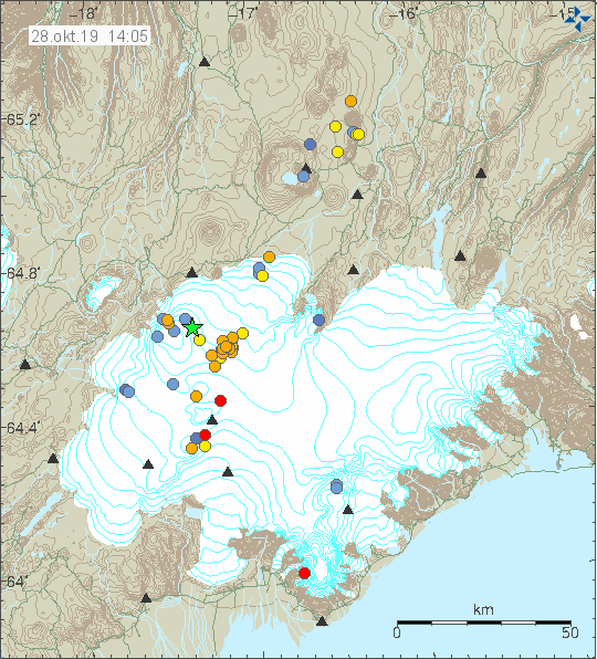
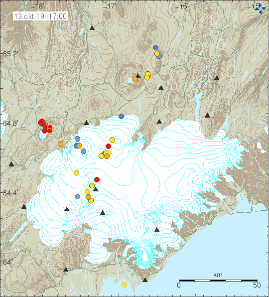
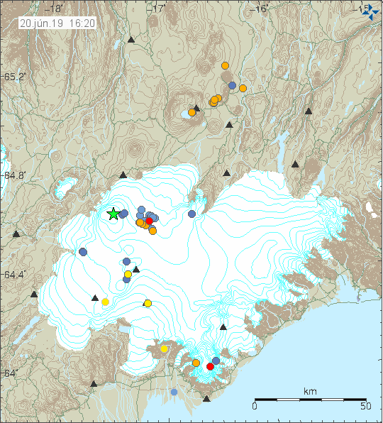
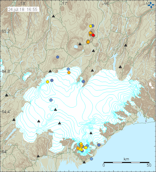
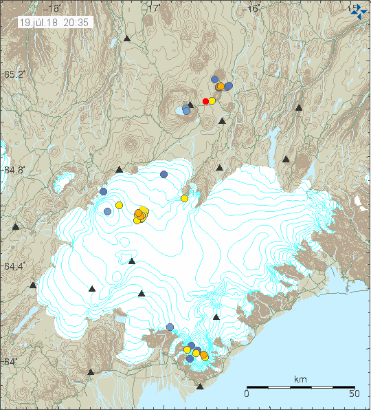
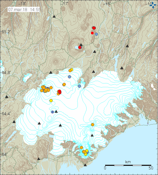
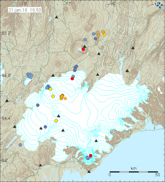
The earthquake activity in Bárðarbunga volcano. Copyright of this image belongs to Icelandic Met Office.


The magnitude 3,9 earthquake as it appeared on my geophone in Dellukot. This image is under Creative Commons Licence, please see CC licence for more details.


The magnitude 3,9 earthquake as it appeared on my geophone in Böðvarshólar. This image is under Creative Commons Licence, please see CC licence for more details.


The second magnitude 4,7 earthquake as it appeared on my geophone in Dellukot. For some unknown reason (maybe bad weather) I was unable to properly record the magnitude 4,7 earthquake at 23:26 UTC. This image is under Creative Commons Licence, please see CC licence for more details.


The second magnitude 4,7 earthquake as it appeared on my geophone in Böðvarshólar. For some unknown reason (maybe bad weather) I was unable to properly record the magnitude 4,7 earthquake at 23:26 UTC. This image is under Creative Commons Licence, please see CC licence for more details.

At the moment no eruption has been detected. But this strong and increasing earthquake activity suggest that magma pressure inside Bárðarbunga volcano might be reaching critical point. If it has not reached critical point already. For the next 24 – 36 hours really bad weather is forecasted in Iceland. With wind gusts forecasted up to 45m/s in the highland and in northern Iceland. This bad weather is going to cause problems in detecting earthquakes in Bárðarbunga volcano and elsewhere.

Donations

Please remember to support my work with donations. Thanks for the support. 🙂

Earthquake activity in Öræfajökull and Kverkfjöll volcano

Since this volcanoes are in the same part of Iceland I am going to write about them in the same article.

Öræfajökull volcano

I don’t think this was a glacier earthquake activity happening in Öræfajökull volcano. I don’t know how many earthquakes took place this time around. Largest earthquakes had magnitude of 2,0 and 1,8 all other earthquakes where smaller in magnitude. Currently there is no GPS monitoring for Öræfajökull volcano that I know of.


The earthquake activity in Öræfajökull volcano and Kverlfjöll volcano. Copyright of this image belongs to Icelandic Met Office.

It is noticing how this time the earthquake swarm is all on the east side of the volcano. This earthquake activity is interesting and this also seems to signal an increase in earthquake activity in Öræfajökull volcano at least for the time being. It remains a question if this activity slows down again. Earthquake activity in this part of Iceland only happens due stress changes in Öræfajökull volcano. This is most likely influx of magma into Öræfajökull volcano but it might not erupt right away or at all (at least for a long time).

Kverkfjöll volcano

A minor earthquake swarm took place in Kverkfjöll volcano today (23-September-2017). Largest earthquake in this swarm had the magnitude of 2,1 and the second strongest earthquake had a magnitude of 1,4. The earthquake swarm was in the central part of the volcano. This is the first earthquake swarm since 2015 in Kverkfjöll volcano and the activity that year was mostly due the activity happening in Bárðarbunga volcano next to it (the dike from Bárðarbunga volcano did disturb Kverkfjöll volcano). Since this earthquake activity took place everything has been quiet in Kverkfjöll volcano.

Donations

Please remember to support my work. At the moment my fridge is getting close to be empty and it is the first time since I moved to Denmark that happens. I hope that next month (October) is slightly better. Thanks for the support. 🙂

Glacier cauldrons at top of Bárðarbunga volcano caldera rim

During the eruption in Bárðarbunga volcano and the collapse of the caldera. A hydrothermal activity was seen on top of Bárðarbunga volcano caldera. Since the eruption in Holuhraun ended in February-2015 this hydrothermal activity has dropped, it has increased if anything. At the moment there are several depressions in the Vatnajökull glacier that is on top of Bárðarbunga volcano. Largest of them are 400 meters wide, I am not sure about their length. This cauldrons are around 100 meters deep and for the first time in several hundreds of years have exposed a bed rock that is normally under the glacier. Hydrothermal activity in Bárðarbunga volcano is now such that is able to melt 100 meters of glacier in several months.

This high amount of hydrothermal activity in the main volcano increases my suspicion that Bárðarbunga volcano is far from over. Since this also means that fresh magma is reaching up to 1 km in the crust in the Bárðarbunga volcano caldera rim. I don’t have any map of the locations of the calderas at the moment since none exist or at least has not yet been published. The main concern now is that this is going to increase the risk of sudden glacier floods from Bárðarbunga volcano. This might also increase the risk of sudden short volcano eruptions in Bárðarbunga volcano, either in its slopes or close to the caldera rim. As it is clear that magma has rather clear access to that part of the volcano.

Rúv News article (in Icelandic)

Gat í gegnum jökulinn (Rúv.is, Icelandic, video)

Donations

Please remember to support my work with donations. Everything helps. Thanks. 🙂

Article updated at 23:51 UTC. Text fixes.

Katla volcano update article of 29-July-2017

This article is going to be updated as activity continues in Katla volcano today on 29-July-2017. If an eruption starts (big one) a new article is going to be written for that event.

Overview of the activity during the night and today

It seems that during the night a minor eruption took place (this is just my view). This based on harmonic tremor pulse that appeared in Katla volcano after midnight, the source of the activity seems to be north-west part of the caldera. Possibly where a magnitude 3,0 earthquake had taken place at 00:48 UTC. Harmonic tremor remains unstable and above background levels, at the moment however it seems that current harmonic tremor when this is written is due to glacier flood pushing it self from under the glacier. The water that is moving under the glacier is few hours away from (at best) from appearing in glacier rivers that come from Katla volcano.


The earthquake activity in Katla volcano during the last 48 hours. Copyright of this image belongs to Icelandic Met Office.


Harmonic tremor in Austmannsbunga in Katla volcano at 12:09 UTC. It clearly shows the minor eruption and ongoing harmonic tremor pulse. Copyright of this image belongs to Icelandic Met Office.


Harmonic tremor in Austmannsbunga in Katla volcano at 13:04 UTC. This image shows ongoing activity in the tremor. This is mostly high frequency tremor and that is interesting. What that is not known. Copyright of this image belongs to Icelandic Met Office.


Harmonic tremor in Goðabunga at 12:09 UTC. It clearly shows the night minor eruption and ongoing harmonic tremor. The harmonic tremor is however a lot less visible now on Goðabunga. Copyright of this image belongs to Icelandic Met Office.


Harmonic tremor as it appears on Rjúpnafell (SIL station). This station is at more distance from the source of the harmonic tremor pulse and shows a weaker signal as a result. The night minor eruption is also clear on this SIL station but current harmonic tremor is less visible, it does appear but at much lower level. Copyright of this image belongs to Icelandic Met Office.

Katla volcano has been moved to yellow alert. It is now possible to watch the glacier flood live from here (Rúv.is). Currently the glacier flood is getting smaller, but that might only be a temporarily thing if more water is on its way from Mýrdalsjökull glacier. There has also been a drop in conductivity for now in Múlavísk glacier river.

Announcement in English on Rúv

People advised to stay away from Múlakvísl (Rúv.is)

This article is going to be updated as needed today.