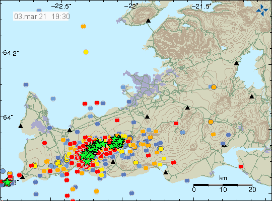
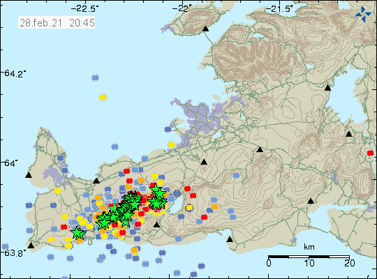
This is a short update since this situation is developing quickly.
No eruption has started at the writing of this article. Harmonic tremor is slightly lower compared to when it started at 14:20 UTC in Krýsuvík volcano. This drop in harmonic tremor started around 16:00 UTC. This harmonic tremor is ongoing as for writing of this article. There are no signs of the rift valley formation on the surface yet, but it does show up on measurements, both GPS and satellite measurements. Earthquake activity is high at the writing of this article but most earthquakes are small in magnitude but there are few earthquakes with magnitude of Mw3,0.
Earthquake activity in Krýsuvík volcano. Copyright of this image belongs to Icelandic Met Office.Earthquake activity trace of the earthquake activity on Reykjanes peninsula. Most earthquakes are in Krýsuvík volcano. Copyright of this image belongs to Icelandic Met Office.
Web cameras of the possible eruption area can be found in this locations.
This article is written at 16:14 UTC. This is just a short update because the situation changes quickly.
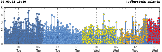
Harmonic tremor has been detected in the Krýsuvík volcano. If an eruption happens as is now expected this is the first eruption in Krýsuvík volcano since the year 1340.
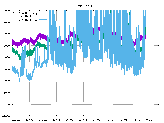
Harmonic tremor detected on SIL station Vogar. Copyright of this image belongs to Icelandic Met Office.Earthquake activity in the Krýsuvík volcano. Copyright of this image belongs to Icelandic Met Office.
A rift valley has been confirmed to have formed in the Krýsuvík close to the area where the eruption is expected. This is between Keilir and Fagradalsfjall mountains. It is possible to watch live stream from this area on YouTube here.
Update at 16:41 UTC
Second web camera that is run by Rúv can be found here.
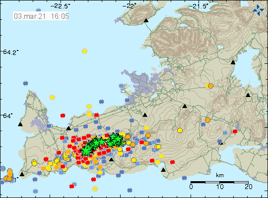
This is a short update on the activity in Krýsuvík volcano. The activity has been confirmed to be only in Krýsuvík volcano and nothing is currently happening in Reykjanes volcano at the writing of this article.
Krýsuvík volcano started to show changes in late 2008 and early 2009 and that has been going on since then in low activity. Krýsuvík volcano is strange in that it does not have any shallow magma chamber in the top layers of the crust and Krýsuvík volcano size is unclear. This uncertainty shows in maps as different maps show different size and location of Krýsuvík volcano. While there is no shallow magma chamber in Krýsuvík volcano it does not rule out a deep, large magma chamber that does not show up on any seismometer since this magma chamber is located in the top layers of the mantle (10 to 30 km).
Earthquake activity in Krýsuvík volcano. Copyright of this image belongs to Icelandic Met Office.
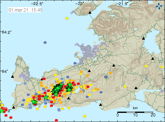
Largest earthquakes since midnight had a magnitude of Mw4,6 and since around 12:00 it has been rather quiet in Krýsuvík volcano when it comes to large earthquakes. A lot of smaller earthquakes have been taking during all this time and there is no sign of those stopping. The reason for all this earthquake activity is a magma dyke that is now breaking its path up to the surface from around 10 km depth. There are nothing to suggest that process is about to stop or slow down. Drop in activity as is now happening are common feature of this type of dyke activity and was seen just before the eruption in Bárðarbunga volcano (Holuhraun) in 2014 to 2015.
Earth Science department of University of Iceland released a pictures that show how this dyke in Krýsuvík volcano works and that image can be viewed here on Facebook.
If anything major happens I am going to post an update soon as possible. Next update is tomorrow (03-March-2021) if activity remains as it currently is.
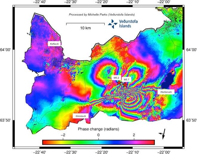
Today (1-March-2021) it was confirmed that Krýsuvík volcano is having a large magma injection from depth into the shallower layers of the crust. Resulting in the current earthquake swarm. At the writing of this article it seems that the magma is located at around 6 km depth. Detected displacement by GPS recordings is now more than 30cm according to the news and scientists.
Inflation map of Reykjanes peninsula showing displacement. Copyright of this image belongs to Icelandic Met Office.
The image above is from here on Facebook. What is also interesting is the activity in Reykjanes volcano. There have also been earthquakes in Reykjanes volcano but they have been fewer but not necessarily smaller in magnitude
Next article is going to be tomorrow (02-March-2021) if nothing major happens.
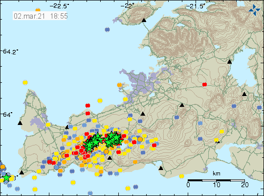
Update 2-March-2021 at 13:40 UTC
This morning it was confirmed that the volcano that is having a major dyke intrusion is the volcano Krýsuvík and not the volcano Reykjanes as I first thought since earthquake activity for the last 14 months has been most active in this volcano. This article has been corrected in light of this information. The border between the two volcanoes is little unclear on the map and even different between maps.
This is a short update on activity in Reykjanes and Krýsuvík volcanoes.
There has not been a lot of change in the earthquake activity in Reykjanes volcano. There has been a slight increase in earthquake activity compared to yesterday (28-Febrary-2021) but that increase is not a lot and only from 800 earthquakes to 1000 earthquakes for a 12 hour time period according to the news. Largest earthquake in last 24 hours had a magnitude of Mw4,9 and was felt over a wide area in West Iceland and was clearly felt in Reykjanes area.
The earthquake activity on Reykjanes peninsula. Copyright of this image belongs to Icelandic Met Office.
There have now been two earthquakes outside Reykjanestá out in the ocean. A swarm of earthquakes started to appear at that location few hours ago. It is unclear what this earthquake activity means for now. This earthquake activity is something that needs to be watched since it seems to be connected for some unknown reason to the main earthquake activity on Reykjanes peninsula.
Update at 16:57 UTC
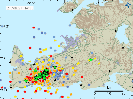
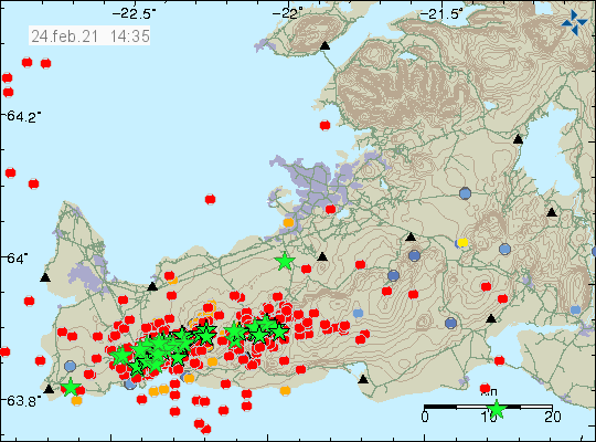
The newest earthquake has the magnitude of Mw5,1 at 16:35 UTC. This earthquake was felt over a wide area in western Iceland and all over Reykjanes peninsula.
PayPal button
Since I was lazy and I had not closed down my PayPal account I made a reversal in change that I had made. It is now possible to support me with PayPal donation. Donations along with advertisement income from this website help me to keep writing about earthquake and volcano activity in Iceland and try to live some type of life at the same time. Thanks for the support. 🙂
Article updated at 16:58 UTC.
Article updated at 23:35 UTC.
I have now switched to daily update for the earthquake swarm in Reykjanes and Krýsuvík volcanoes.
The situation in the earthquake swarm on Reykjanes peninsula in the volcanoes Reykjanes and Krýsuvík remains the same. During the last 24 hours the largest earthquakes have had magnitude of Mw4,7 and a lot of earthquakes with magnitudes above M3,0. No magma movement has been detected so far but University of Iceland – Earth science department warned that detection of magma is only limited to the first 5 km of Earth crust and any magma movement below 5 km might not be detected by seismometer. It also issued that signs of magma might be getting lost in all this earthquake activity that is currently taking place and no clear sign of magma have been detected. The whole thing can be read on Facebook here. Text in English is provided by Eldfjallafræði og náttúruvárhópur Háskóla Íslands about this.
Current earthquake activity on Reykjanes peninsula. Copyright of this image belongs to Icelandic Met Office.
Some of the earthquake activity has migrated closer to the mountain Keilir. Other earthquake activity appears to be located at the same place as before. That location is close to Fagradalsfjall mountain and Krýsuvík volcano. If that changes anything when it comes to this earthquake activity I don’t know but the risk is there. Icelandic Met Office is now hoping that the earthquake swarm ends next week.
If anything major happens I’ll post new article soon as possible.
This is a short update on the activity on Reykjanes and Krýsuvík volcanoes.
Largest earthquake in the last 24 hour had a magnitude of Mw5,2 at 08:17 UTC and this earthquake was felt over a wide area in west Iceland. Over the last 48 hours there have been 95 earthquakes with magnitude above Mw3,0. GPS is showing a lot of displacement and those information can be found here. Largest displacement has been in and around Krýsuvík and other GPS stations on Reykjanes peninsula.
Earthquake activity on Reykjanes peninsula. Copyright of this image belongs to Icelandic Met Office.
Cracks have also formed in one road and other surface damage and other small damages have started to appear in buildings and roads on Reykjanes peninsula. There is going to be a storm in Iceland until early 2-March-2021. This storm is going to reduce the detection of smaller earthquakes in this earthquake swarm while it goes over Iceland.
All this information can change without warning.
News about cracks in the road on Reykjanes peninsula
This is a short update on activity in Reykjanes and Krýsuvík volcanoes. This update is written at 19:28 UTC.
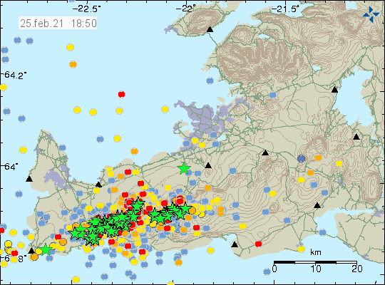
The activity today (25-February-2021) has been mostly just minor earthquakes. Largest earthquakes today had a magnitude of Mw3,5 but this number can still change. In the last 24 hours over 2500 earthquakes have been recorded by Icelandic Met Office according to the news.
Earthquake activity on the Reykjanes peninsula over the last 48 hours. Copyright of this image belongs to Icelandic Met Office.
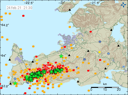
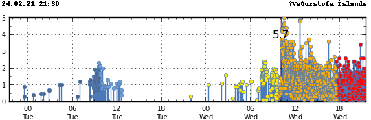
Steam has been confirmed close the parking lot close to Keilir mountain on Reykjanes peninsula. This area did not have steam before the Mw5,7 earthquake yesterday (24-February). It is unclear that is going on in that location. There continues to be high risk for a earthquake with magnitude Mw6,0 to Mw6,8 on Reykjanes peninsula because of this earthquake activity.
I’ll post update soon as possible if anything happens.
This is a short update at 21:19 UTC about the earthquake activity in volcanoes Reykjanes and Krýsuvík.
Earthquake activity slowed little since last update at 14:41 UTC. There are now fewer larger earthquakes taking place at the writing of this article. That has the chance of changing without warning. There seems to be new areas of activity appearing on the automatic Icelandic Met Office map. It is unclear if this is a artifact of the heavy earthquake activity in the area or a real thing is difficult to know for sure at the writing of this article.
Earthquake activity on the Reykjanes peninsula. Copyright of this image belongs to Icelandic Met Office.Earthquake activity on the Reykjanes peninsula. Copyright of this image belongs to Icelandic Met Office.
Currently there are no signs of magma moving in both volcano systems. That might change without warning if there is a sudden change in activity. Because of how long it has been since last eruption took place in both volcanoes what happens before an eruption is unclear. What is only known from around 681 year old historical records that did survive to this day is that earthquake activity increases sharply before an eruption and does so a good while before the first eruption happens. Last eruption in Krýsuvík volcano was in the year 1340.
I am going to post next update tomorrow (25-February-2021) unless something major happens and then I’ll post a new article soon as possible.
According to new pictures from Icelandic Coast Guard. Steam has been seen from the area that had the strongest earthquakes this morning. This seems to be in a area that did not have an earlier any steam activity, this however depends a confirmation.
The earthquake activity on the Reykjanes peninsula. Copyright of this image belongs to Icelandic Met Office.
Icelandic News about the steam activity that has been detected.
We use cookies on our website to give you the most relevant experience by remembering your preferences and repeat visits. By clicking “Accept”, you consent to the use of ALL the cookies.
This website uses cookies to improve your experience while you navigate through the website. Out of these cookies, the cookies that are categorized as necessary are stored on your browser as they are essential for the working of basic functionalities of the website. We also use third-party cookies that help us analyze and understand how you use this website. These cookies will be stored in your browser only with your consent. You also have the option to opt-out of these cookies. But opting out of some of these cookies may have an effect on your browsing experience.
Necessary cookies are absolutely essential for the website to function properly. This category only includes cookies that ensures basic functionalities and security features of the website. These cookies do not store any personal information.
Functional cookies help to perform certain functionalities like sharing the content of the website on social media platforms, collect feedbacks, and other third-party features.
Performance cookies are used to understand and analyze the key performance indexes of the website which helps in delivering a better user experience for the visitors.
Analytical cookies are used to understand how visitors interact with the website. These cookies help provide information on metrics the number of visitors, bounce rate, traffic source, etc.
Advertisement cookies are used to provide visitors with relevant ads and marketing campaigns. These cookies track visitors across websites and collect information to provide customized ads.