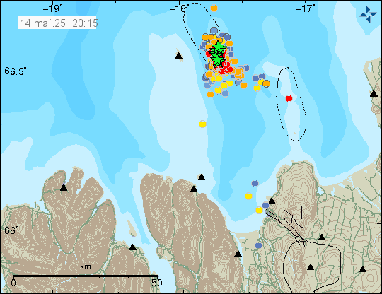
Today (14-May 2025) at 05:20 UTC an earthquake with the magnitude of Mw4,9 to Mw5,0 (Icelandic Met Office). EMSC is reporting this earthquake at Mw4,6 (information here). This earthquake was felt in Grímsey and south to Akureyri town.
The earthquake swarm east of Grímsey island. Copyright of this image belongs to Icelandic Met Office.
This earthquake swarm has been showing signs of happening in waves, with quiet or lower activity between them. What that means is unclear. More strong activity might happen in next few hours or next few weeks. This earthquake swarm might also just stop suddenly, as happens frequently in this area. I am not seeing any signs of magma movement in this area.
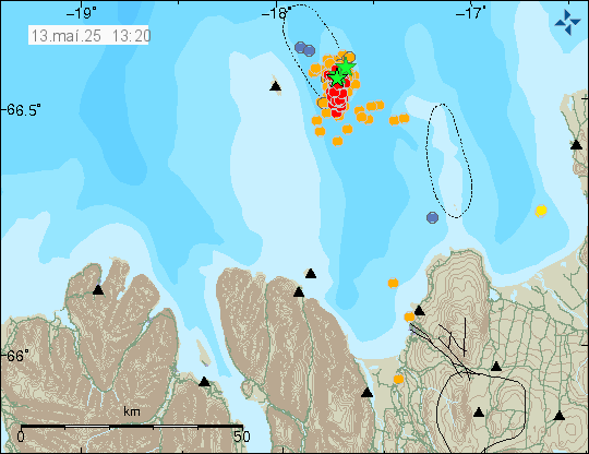
This morning on 13. May 2025 at 04:02 UTC an magnitude Mw4,7 earthquake took place in Tjörnes Fracture Zone just east of Grímsey island. This earthquake was felt in Grímsey and woke people up there. It was also felt in parts of north Iceland. Total of seven earthquakes with magnitude Mw3,0 or larger have taken place in this area during this earthquake swarm.
Earthquake swarm east of Grímsey island. Copyright of this image belongs to Icelandic Met Office.
This earthquake swarm is ongoing at the writing of this article. It has been slowing down, there is a chance activity might increase again, but it is difficult to be sure. Often earthquake activity in this area just stops over time period of few days.
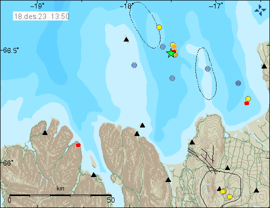
During the night and into the morning of 18. December 2023 an earthquake swarm took place in Tjörnes Fracture Zone just south east of Grímsey island. Largest earthquake in this swarm had a magnitude of Mw3,4 at 08:06 UTC and was felt in Húsavík, Akureyri and Grímsey according to the news. Other earthquakes in this swarm where smaller in magnitude.
Earthquake activity in Tjörnes Fracture Zone. Copyright of this image belongs to Icelandic Met Office.
Earthquake activity in this area is common and larger earthquakes are frequent. Earthquake swarms happen regularly. This earthquake swarm seems to have ended.
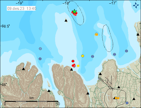
Today (9. December 2023) an earthquake swarm took place east of Grímsey island, it started at 11:09 UTC and ended around 12:19 UTC. This was a small earthquake swarm and largest earthquake had a magnitude of Mw3,0.
Earthquake swarm east of Grímsey island. Copyright of this image belongs to Icelandic Met Office.
This area of Tjörnes Fracture Zone has frequent earthquakes and earthquake swarm activity. Large earthquake swarms happen in this area every few years. Time between them is different. If that is the case now is impossible to know.
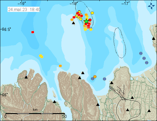
Yesterday (23. May 2023) at 19:22 UTC an earthquake swarm started east of Grímsey island. Largest earthquake had a magnitude of Mw3,8 at the writing of this article. This earthquake swarm is ongoing. The largest earthquake was felt in Akureyri and other nearby towns.
Earthquake activity east of Grímsey island. Copyright of this image belongs to Icelandic Met Office.
Around 130 earthquakes have happened in this earthquake swarm so far. This area of Iceland has frequent earthquake activity. This earthquake swarm might increase, as they sometimes do in this area. It is impossible to know when this activity is going to stop. It took me a little longer to write this article, because this is a frequent earthquake area and I was also trying to get a little break (I also have to do other things outside of this) in next few days from geology. How that goes is to be seen.
I also want to point people out that I have set-up a website that shows Icelandic Met Office harmonic tremor charts and other information for that area.
I also have a webicorder website with an earthquake recording that I run. I am trying to figure out how to install and run seismometer in Iceland again. Its a slow work in progress for me because of the technical problems I am dealing with.
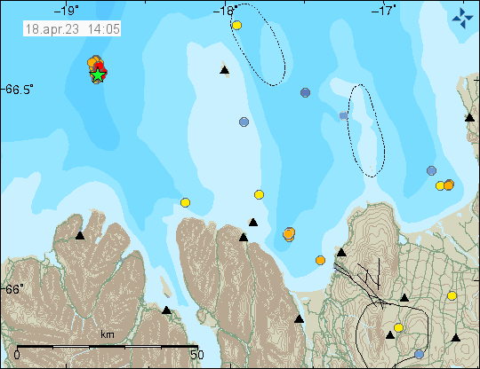
Today (18. April 2023) at 07:59 UTC an earthquake swarm started west of Grímsey island. The distance is around 36 km west of Grímsey island. Largest earthquake in this swarm had a magnitude of Mw4,2 and was felt in Siglufjörður and Akureyri towns.
Earthquake swarm west of Grímsey island. Copyright of this image belongs to Icelandic Met Office.
At the writing of this article, this earthquake swarm is ongoing and there’s a risk of stronger earthquakes in this area. This area last had a major earthquake swarm in June 2020. With largest earthquake in that swarm having a magnitude of Mw5,8.
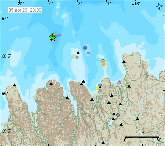
A minor earthquake swarm took place around 43 km west of Grímsey island. The largest earthquakes in this swarm where not felt because of distance from populated areas. This earthquake swarm took place on a north end of a rift valley that is at this location and goes all the way to Akureyri and little south of Akureyri town. Where it ends is unclear.
Earthquake swarm on Tjörnes Fracture Zone. Copyright of this image belongs to Icelandic Met Office.
Largest earthquake in this small earthquake swarm had a magnitude of Mw3,5. This area had a large earthquake swarm in June 2020 with the largest earthquake in that swarm reaching magnitude of Mw5,8 that was felt over a large area in north Iceland. Large earthquake swarms happen in this rift valley regularly. I am not sure how often it does happen. More earthquakes in this area might be possible without any warning. Distance from land makes it difficult to record earthquakes at this location if they are small in magnitude.
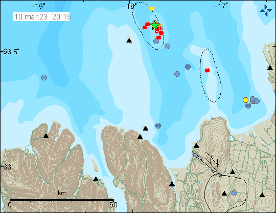
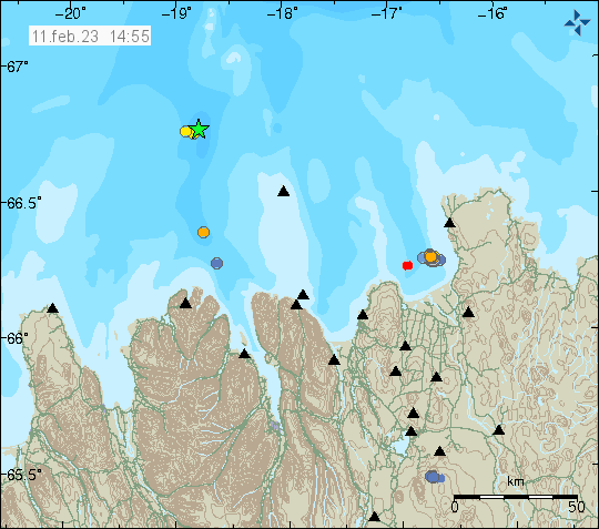
Yesterday (9. March 2023) and today (10. March 2023) an earthquake swarm has been east of Grímsey island. Largest earthquake in this swarm had a magnitude of Mw3,8. There have been around 40 to 60 earthquakes in this swarm. Making this earthquake swarm rather small, compared to many other earthquake swarm that have been at this same location.
Earthquake activity east of Grímsey island. Copyright of this image belongs to Icelandic Met Office.
This earthquake swarm seems to be ongoing at of the writing of this article. It is impossible to know for sure if an stronger earthquake is going to happen in this area.
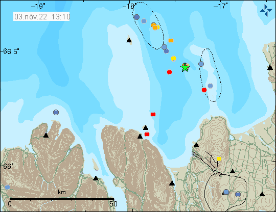
Today (3-November-2022) at 11:06 UTC an earthquake with magnitude of Mw3,2 took place in Tjörnes Fracture Zone. This earthquake took place a bit of a distance from land. This earthquake seems to be part of an activity that is now happening in Tjörnes Fracture Zone. This seems to be an ongoing earthquake swarm in this area.
Earthquake activity in Tjörnes Fracture Zone. Picture from Icelandic Met Office.
It is difficult to know what this earthquake activity means, if it means anything. Its been a while since Tjörnes Fracture Zone had a strong earthquake above Mw6,0 in this area and north of it. Earthquakes in Tjörnes Fracture Zone can go up to Mw7,0 in magnitude, those are rare and happen only after a long time period of quiet it seems.