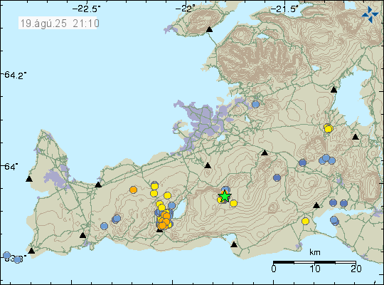
On 18-August 2025 at 18:10 UTC an earthquake with magnitude of Mw3,8 took place in Brennisteinsfjöll volcano. This earthquake was felt in Reykjavík and nearby towns.
Earthquake swarm in Brennisteinsfjöll volcano. Copyright of this image belongs to Icelandic Met Office.
This earthquake swarm has stopped. There is a lot of stress on the crust in this part of Reykjanes because of the ongoing inflation and deflation cycle in Svartsengi volcano. Larger earthquake might happen without warning.
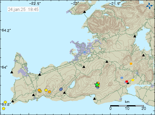
Today (24-January 2025) at 06:06 UTC an earthquake with the magnitude of Mw3,0 took place in Brennisteinsfjöll volcano. This doesn’t seem to have connected to magma movement in this area or volcano. This looks like more like a tension related earthquake. It was probably not related to inflation in Svartsengi volcano.
Green star in Brennisteinsfjöll volcano. Copyright of this image belongs to Icelandic Met Office.
There is a risk of stronger earthquakes in this area. Currently there are no signs that this connected to magma movement in this area.
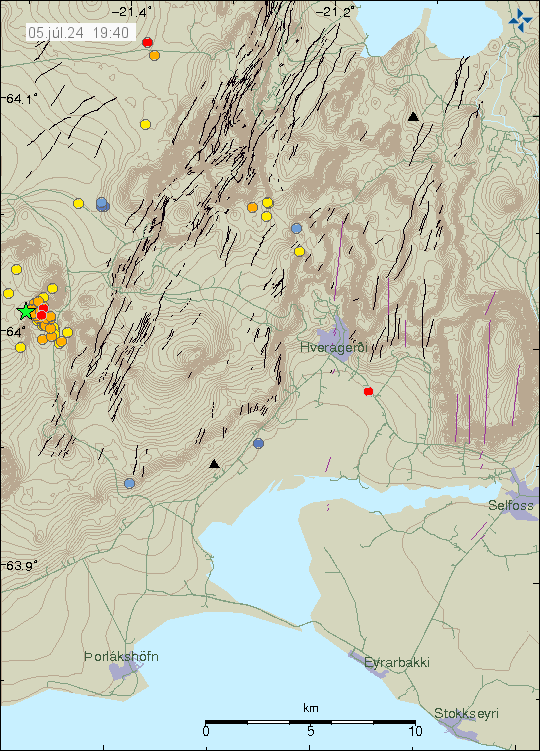
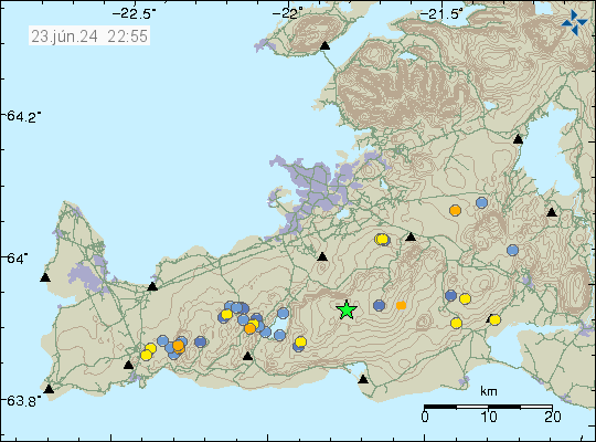
Today (5-July 2024) an earthquake swarm started in Brennisteinsfjöll volcano. Largest earthquake had a magnitude of Mw3,1 at 07:17 UTC. This earthquake was felt in Reykjavík and nearby areas.
Earthquake activity in Brennisteinsfjöll volcano. Copyright of this image belongs to Icelandic Met Office.
At the writing of this article, the earthquake swarm seems to have stopped. It might restart again, since that is common in this volcano and in this area.
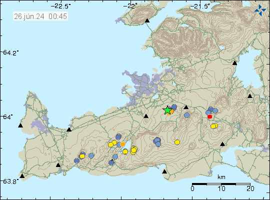
Yesterday (26-June 2024) at 17:07 UTC an earthquake with magnitude of Mw3,1 took place in Brennisteinsfjöll volcano, not far from Bláfjallaskáli area. That is a popular skiing area during the winter.
The earthquake activity in Brennisteinsfjöll volcano. Copyright of this image belongs to Icelandic Met Office.
This earthquake was part of a small earthquake swarm in the same area. It seems to have quieted down again.
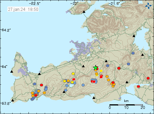
Yesterday (26. January 2024) and today (27. January 2024) an earthquake activity took place in Brennisteinsfjöll volcano, in the Bláfjöll area. The first earthquake had a magnitude of Mw2,4 at 22:54 UTC on 26. January 2024 and the second earthquake had a magnitude of Mw3,1 on 27. January 2024 at 05:28 UTC. Smaller earthquakes started later today. That earthquake activity seems to have ended at the writing of this article.
Earthquake activity in Brennisteinsfjöll volcano and other areas on Reykjanes peninsula. Copyright of this image belongs to Icelandic Met Office.
This earthquake activity, at least in the case of the Mw2,4 and Mw3,1 earthquake did show a sign that they where created by magma movement, among those signs was a strong vertical movement and low period signal that only happens when magma creates earthquake. At this point in time, I don’t think an eruption is going to happen any time soon. It is possible that magma has started to collect in Brennisteinsfjöll volcano. It is going to be several years until something more happens, it might even take decades before anything serious happens.
I am sorry that I am late on writing this article. I was moving from Denmark to Iceland and that was a lot of effort and I’ve been tired after this move.
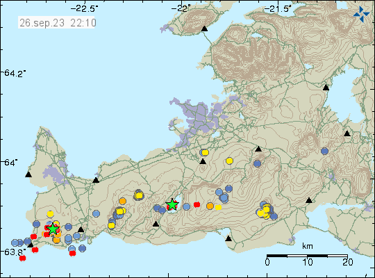
On Sunday, 24 September 2023 an earthquake swarm took place in Brennisteinfjöll volcano, in a area called Geitarfell (Goat Mountain) in Brennisteinsfjöll volcano. Largest earthquakes had a magnitude of Mw3,0 to Mw3,2. A lot of smaller earthquakes took place at this same location.
Yellow dots show the Sunday earthquake activity. Copyright of this image belongs to Icelandic Met Office.
This earthquake activity didn’t have any short term signs that an eruption is about to happen at this location. I don’t know when last eruption took in this location, but it was clearly more than 6000 years ago.
Earthquake webicoders
Since I have moved back to Iceland. I am now recording earthquakes again. The webicoders are going to go online tomorrow (if no delays). They can be found here once they are back online.
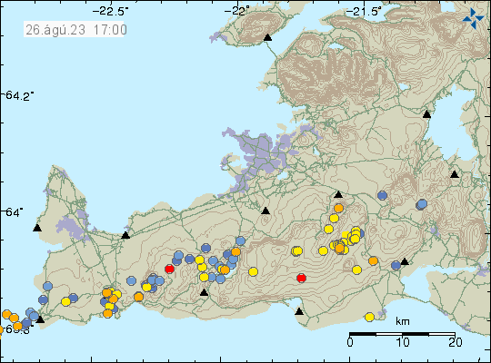
During the night of 26. August 2023 an dyke intrusion started in Brennisteinsfjöll volcano. This was in the form of many small earthquakes, most of them did not reach magnitude Mw1,0. What gives this away as an dyke intrusion is the fact the deepest earthquake in this swarm had a depth of 21,1 km. There was interestingly, a lot of surface earthquakes. I am not sure on why that is.
Earthquake activity in Brennisteinsfjöll volcano. Copyright of this image belongs to Icelandic Met Office.
There’s no risk of eruption at the moment from Brennisteinsfjöll volcano. Earthquake activity is too low and this process is clearly not far along now for an eruption too happen. That might change without much warning at some point.
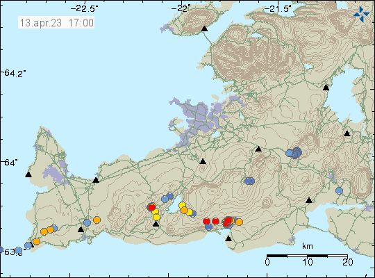
Today (13. April 2023) there has been a small earthquake swarm in south part of Brennisteinfjöll volcano. This location had an earthquake swarm few weeks ago at this same location. It also was small in magnitude. Depth of this earthquake swarm has now decreased from 7 km to around 3 km. At least that is what it seems, based on the current earthquake data.
Earthquake activity in Brennisteinsfjöll volcano. Copyright of this image belongs to Icelandic Met Office.
This earthquake activity shows a sign of magma movement. It is my opinion that the magma is now pushing it self trough the crust at this location. That can take a while, up to several weeks before an eruption starts. I did see something similar happen before the Bárðarbunga volcano eruption in 2014. That process took good three months before the eruption and was marked by small earthquake swarm like this one. How long this is going to take is impossible to know, because what type of crust is at this location is not well understood (outside of types of rock it is made out of at the first top layers). This is in my view an earthquake activity that needs to be monitored, because of possible eruption risk at this location. This is directly north of a small lake south of the earthquake swarm. If an eruption happens and the lava flows into the lake, that might create a lot of problems.
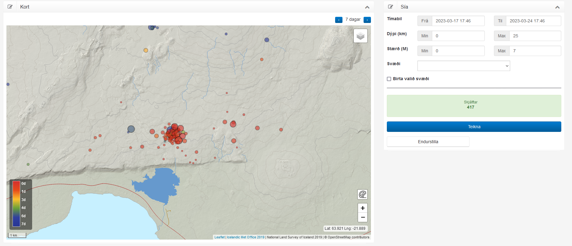
This earthquake swarm can be viewed here in more details. The website is Skjálfta-Lísa and is only in Icelandic.
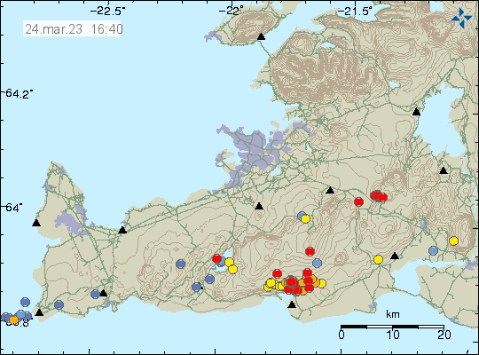
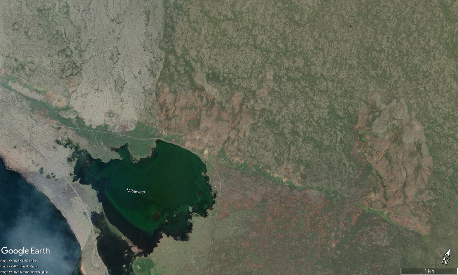
Earlier this week, an swarm of earthquakes started in south of Brennisteinsfjöll volcano, also known as Bláfjöll mountain. This earthquake swarm started on a west to east fault north of a lake called Hlíðarvatn. This earthquake swarm has only been minor earthquakes, with magnitudes in the range of Mw0,0 and up to Mw2,3 but at the writing of this article, nothing above that magnitude. Over the week this earthquake swarm has evolved into a single area that seems to be circular, based on current earthquake activity. This strongly suggests that magma is the reason why this earthquake swarm is happening.
Earthquake activity in Breinnisteinsfjöll volcano. Copyright of this image belongs to Icelandic Met Office.Earthquake as they appear on Skjálfta Lísa website from Icelandic Met Office. Screenshot from Icelandic Met Office website Skjálfta Lísa.Google Earth image of the area where the earthquake swarm is taking place. Picture is from Google Earth.
At the writing of this article, the earthquake activity is too small to start an eruption. Since this area is cold and the crust is too hard for the magma to flow freely inside it. Current depth of the earthquakes is around 5 to 7 km at the writing of this article and has not changed a lot during the week. While the Skjálfta Lísa image does not show this, it is possible that the earthquake activity has started to spread more east, compared to earlier in the week when this activity started. This earthquake actiivty might stop, as often happens in the early stages of a new eruption cycle in a volcano.