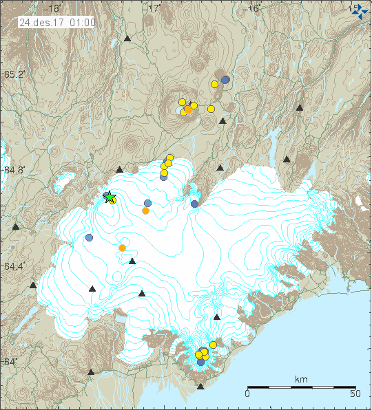
Earthquake swarm in TFZ close to Kópasker village

Today (08-November-2017) a small earthquake swarm happened west of Kópasker village. Largest earthquake in this swarm had magnitude of 3,0 and the second largest magnitude was 2,2 (foreshock).


The earthquake activity in TFZ. The green star shows the location of this earthquake swarm.

This earthquake swarm seems to be over at the moment but there is always a lot of earthquake activity in TFZ. Earthquake activity at this location has been going on for some time now with quiet period between them. There is a good chance that pattern is going to repeat in next few weeks.

Donations

Please remember to support my work with donations. It helps me paying all the bills. Thanks for the support. 🙂

Deep earthquakes in Bárðarbunga volcano system and increased conductivity in Jökulsá á fjöllum glacier river

Today (7-November-2017) there has been deep earthquakes taking place in Bárðarbunga volcano system, just south-east of the main volcano. This earthquakes are not strong and only have the magnitude of 16,4 to 18,8 km. This time none of the earthquakes that happened reached magnitude 1,0.


Location of the deep earthquakes is south-east of the main Bárðarbunga volcano. It is marked by three red dots. Copyright of this image belongs to Icelandic Met Office.

It is also in the news that conductivity in Jökulsá á fjöllum glacier river (map of Jökulsá á fjöllum glacier river can be found here) is at all times high and have been increasing for the last two weeks (14 days) and are now the highest ever recorded. It is unclear at the moment why this is happening as no eruption has been detected from Bárðarbunga volcano during this time. The glacier river is also unusually dark for this time of the year and smell of hydrothermal water has also been detected. Current values are 295µ/cm. This is a risky situation if something more happens under the glacier as this area goes close to Road 1 and connected bridges. If a major flood happens those bridges are going to get lost and there is always a risk of more damage happening, but that depends on factors that are impossible to predict.

Icelandic News – Google Translated can be used for raw translation

Aukin rafleiðni í Jökulsá á Fjöllum (Rúv.is)
Aukin rafleiðni í Jökulsá á fjöllum (Vísir.is)
Raf­leiðni í ánni farið hækk­andi (mbl.is)

Update 1

There is a possibility that this might be a glacier flood from Kverkfjöll volcano. That has not been confirmed as of this moment. Glacier flood from Kverkfjöll volcano happen every few years.

Updated Icelandic News

Hlaup hugsanlegt í Jökulsá á Fjöllum (Rúv.is)
Aukin rafleiðni í Jökulsá á Fjöllum bendir til hlaups (Vísir.is)

Donations

Please remember to support my work with donations. That helps me write reports like this and keep people informed about what is going on. Thanks for the support. 🙂

Article updated at 22:11 UTC.

Earthquake swarm in Öræfajökull volcano

For the last few hours there has been a earthquake swarm in Öræfajökull volcano. I’m not clear on how many earthquakes have so far happened in Öræfajökull volcano at the moment. Most of them have been smaller than 1,5 in magnitude and only few earthquakes with magnitude 2,0 and above have so far happened. This is a unusual earthquake swarm and possibly the largest one since the unrest started in Öræfajökull volcano few years ago.


The earthquake activity in Öræfajökull volcano at the south end of Vatnajökull glacier. Copyright of this image belongs to Icelandic Met Office.

This earthquake swarm is on a line that is almost north-south direction and that is interesting as it crosses the crater of Öræfajökull volcano. That type of pattern appeared last month during the earthquake swarms that took place then. Between now and then there has just been few earthquakes here and there in the volcano. Old history tells (from the eruption 1362) that before the main eruption at least two earthquakes are felt nearby. How accurate that documentation is questionable due its age and possible rewrite over history. Detailed report on Öræfajökull volcano can be found here (pdf) by Icelandic Met Office. Historical data shows that eruption from Öræfajökull volcano are powerful and can lost for a short time (1326 eruption), but they can also last for few months like the 1727 eruption that started in August 3rd and ended on May 1728 (+- 30 days error margin).

Notice on Esjufjöll volcano

There has also been a minor increase in earthquake activity in Esjufjöll volcano. This seems to be a side effects of the activity in Öræfajökull volcano. Why and how that works is unknown to me. I don’t expect any eruption to take place in Esjufjöll volcano. Last eruption was possibly in the year 1920 and was short lived (few hours?). I don’t know how long this earthquake activity has been going on in Esjufjöll volcano, but it is mentioned in a Icelandic Met Office report from 2002, that report can be read here (pdf).

Donations

Please remember to support my work with donations. Thanks for the support. 🙂

Strongest earthquakes in Bárðarbunga volcano since February 2015

Yesterday (26-October-2017) and today (27-10-2017) two strongest earthquake took place in Báðarbunga volcano since end of the eruption in February 2015. The magnitudes of earthquakes so far are two Mw4.7, One magnitude Mw3,9 and one Mw3,2 earthquake. So far other earthquakes have been smaller in magnitude. No harmonic tremor has been detected so far, but given the location an eruption might start in other part of the caldera without warning even if the earthquake swarm activity is happening in the northern part of the Bárðarbunga volcano caldera.


The earthquake activity in Bárðarbunga volcano. Copyright of this image belongs to Icelandic Met Office.


The magnitude 3,9 earthquake as it appeared on my geophone in Dellukot. This image is under Creative Commons Licence, please see CC licence for more details.


The magnitude 3,9 earthquake as it appeared on my geophone in Böðvarshólar. This image is under Creative Commons Licence, please see CC licence for more details.


The second magnitude 4,7 earthquake as it appeared on my geophone in Dellukot. For some unknown reason (maybe bad weather) I was unable to properly record the magnitude 4,7 earthquake at 23:26 UTC. This image is under Creative Commons Licence, please see CC licence for more details.


The second magnitude 4,7 earthquake as it appeared on my geophone in Böðvarshólar. For some unknown reason (maybe bad weather) I was unable to properly record the magnitude 4,7 earthquake at 23:26 UTC. This image is under Creative Commons Licence, please see CC licence for more details.

At the moment no eruption has been detected. But this strong and increasing earthquake activity suggest that magma pressure inside Bárðarbunga volcano might be reaching critical point. If it has not reached critical point already. For the next 24 – 36 hours really bad weather is forecasted in Iceland. With wind gusts forecasted up to 45m/s in the highland and in northern Iceland. This bad weather is going to cause problems in detecting earthquakes in Bárðarbunga volcano and elsewhere.

Donations

Please remember to support my work with donations. Thanks for the support. 🙂

Earthquake activity in south part of Bárðarbunga volcano caldera

Today (24-October-2017) at 14:18 UTC a magnitude 4,1 earthquake took place in south part of the Bárðarbunga volcano caldera. Few moments later at 14:54 UTC a magnitude 3,4 earthquake took place and few other earthquakes followed.


The earthquake activity in Bárðarbunga volcano. Copyright of this image belongs to Icelandic Met Office.

What is different now is that the earthquake activity is now happening in south part of the caldera. Close to the area where deep cauldrons have appeared due to shallow magma at this location. This makes the earthquake activity at this highly interesting and possibly highly dangerous if magma has now started to push it’s way up at this location. A small eruption at this location could result in a serious glacier flood, even if such an eruption only lasted for few hours.


The magnitude 4,1 earthquake as it appeared on my geophone in Dellukot. This image is under Creative Commons License, please see CC License for more details.


The magnitude 4,1 earthquake as it appeared on my geophone in Böðvarshólar. This trace has been filtered at 4Hz. This image is under Creative Commons License, please see CC License for more details.

It remains a question if an earthquake is going to happen in north-east part of the Báðarbunga volcano caldera in next few days. That seems to happen when a earthquakes takes place in south part of the caldera. I don’t know why that happens, it is just seems to do.

Article updated at 23:48 UTC. Text fixes.

Donations

Please remember to support my work with donations. It helps me keeping this website running and other things. Thanks for the support. 🙂

Strong earthquake swarm in south Iceland yesterday (20-October-2017) – minor damage reported

Yesterday (20-October-2017) a strong earthquake swarm happened in south Iceland on the SISZ fault zone. This earthquake swarm is currently ongoing and stronger earthquakes cannot be ruled out at this point.


The earthquake swarm as of the writing of this article. Copyright of this image belongs to Icelandic Met Office.

Largest earthquake that has happened so far had the magnitude of 4,1 and four magnitude 2,9 earthquakes have happened at the writing of this article. During the strongest earthquake yesterday some minor damage has been reported, items falling out of shelves and breaking, picture frames getting skewed on walls. For a short time the village of Stokkseyri lost all line phone communication, I don’t know how long that outage lasted but phone service was restored quickly according to the news on Rúv. Largest earthquake was felt over a wide area, all the way to Reykjavík and up to Akranes village and east to Hella village.


The magnitude 4,1 earthquake as it appeared on my geophone in Dellukot. This image is under Creative Commons Licence, please see CC Licence page for more details.


The magnitude 4,1 earthquake as it appeared on my geophone in Böðvarshólar. This image is under Creative Commons Licence, please see CC Licence page for more details.

I don’t know if this earthquake activity signals a new period of earthquake swarm in SISZ. I have listed large history of earthquakes of the SISZ in a article from 2011 here.

Donations

Donations help me running this website properly and keep everything going properly. Donations also help me to buy food and pay the bills so I can write more articles about earthquakes in Iceland and future eruptions that are going to happen in Iceland. Thanks for the support. 🙂

Strong earthquake swarm in Tjörnes Fracture Zone this morning (19-October-2017)

Today (18-October-2017) at 06:00 UTC (Icelandic time) people of Grímsey Island got a rude awaking when a magnitude 3,8 to 3,9 earthquake took place. At 05:01 UTC a magnitude 2,9 earthquake had taken place. For the past 48 hours total of 105 earthquakes have taken place in the Tjörnes Fracture Zone. The largest earthquake took place in what seems to be north part of Grímsey Island, there is no population in that part of Grímsey Island but the population lives only few hundred meters away.


The earthquake activity in Tjörnes Fracture Zone in Grímsey Island. Copyright of this image belongs to Icelandic Met Office.

This earthquake activity started in this part of the Tjörnes Fracture Zone on 05-October-2017 as I wrote about here. Since then it is has been continuously ongoing, for a time it looked it was slowly stopping but the earthquake this morning increased the activity again. Since around 19:00 UTC this earthquake swarm seems to have slowed down a bit again, but the earthquake swarm is still ongoing as of writing of this article. More strong earthquakes in this area cannot be ruled out.

Donations

Please remember to support my work. Donations are my main source of income from my work here, along with small advertisement revenue and income from what people buy from Amazon with the banners I have on my websites. Thanks for the support. 🙂

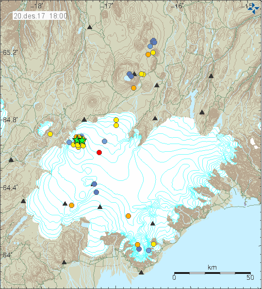
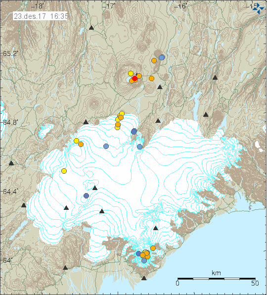
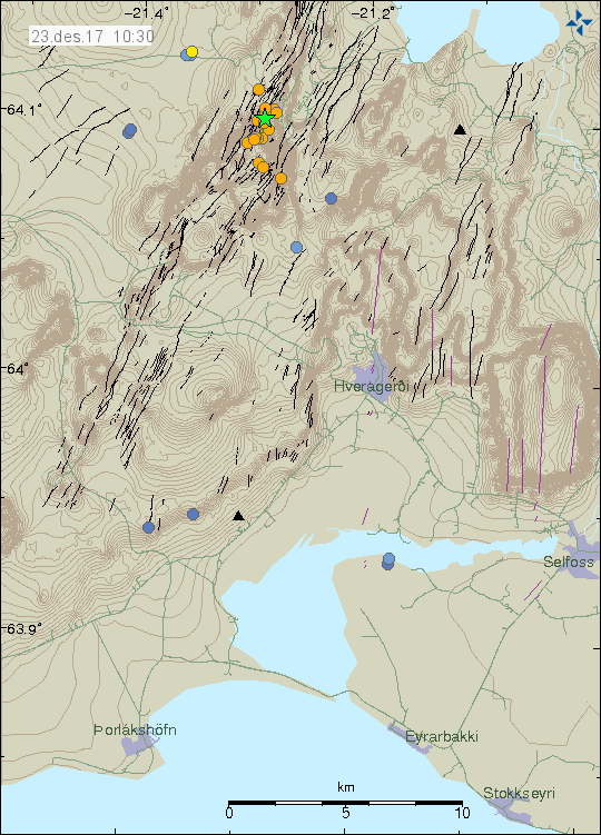
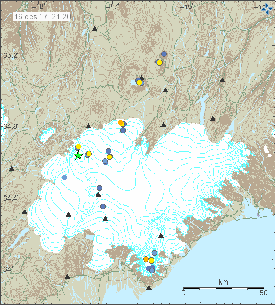
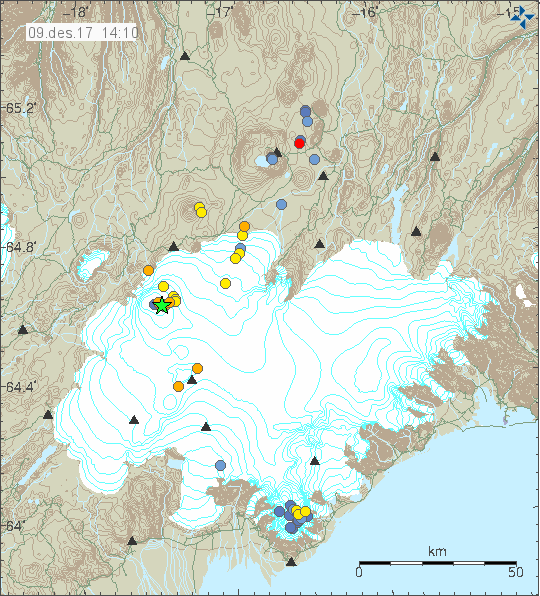
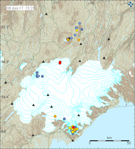
Earthquake activity in Bárðarbunga volcano on 13-October-2017

On Friday 13 of October 2017 there was an earthquake activity in Bárðarbunga volcano. Largest earthquake in this activity had the magnitude of 3,1. Earlier earthquake had the magnitude of 2,9.


The earthquake activity in Bárðarbunga volcano. Copyright of this image belongs to Icelandic Met Office.

This latest earthquake is at an interesting location. This earthquake happens close to or inside the hydrothermal area in the Bárðarbunga volcano caldera rim. This area has not seen a lot of earthquake activity in recent months. Magma at this location is at shallow depth as is shown by the hydrothermal activity. Geologists are estimating that magma is at around 1 km depth at the hydrothermal location. This hydrothermal vents have melted hundreds of meters of glacier already due to how energetic they are. The magnitude 2,9 earthquake took place in the normal north-east place in the Bárðarbunga volcano caldera rim. There is also a interesting cluster of earthquakes in the north part of the caldera happening in last few hours.

At the moment there isn’t anything that suggest that an eruption is imminent in Bárðarbunga volcano.

Donations

Please remember to support my work with donations. Thanks for the support. 🙂

Minor earthquake swarm on Kolbeinsey Island

Today (Sunday 08-October-2017) a minor earthquake swarm took place in Kolbeinsey Island. Only three earthquakes where detected, but that does not rule out that more earthquakes happened but where not detected due to distance from land and the SIL network.


The earthquake activity is marked by the green star to the north on this image. Copyright of this image belongs to Icelandic Met Office.

Largest earthquake detected had the magnitude of 3,1 and the second largest earthquake detected had a magnitude of 2,1. Since 10:33 UTC this morning, that lack of activity does not rule out more activity in next few days.

New SIL station

I did see in the news today that Icelandic Met Office has added a new SIL station at Bjarnarey Island. This increases the earthquake resolution for Vestmannaeyjar area along with improving earthquake detection in Katla volcano and making it possible to detect small earthquakes deeper south of Iceland.

Icelandic news about the new SIL station, Jarðskjálftamælir í Bjarnarey að frumkvæði Vinnslustöðvarinnar (eyjafrettir.is).

Icelandic Met Office has also moved the SIL station in Vestmanneyjar Island around. The old location was not usable any more due to cultural noise from the population in Vestmannaeyjar Island.

Sulphur smell felt from Múlakvísl glacier river

On the 3-October-2017 there was an increase in earthquake activity in Katla volcano as I wrote about here. This activity was deeper than suspected as during the night there was an small harmonic spike as was mentioned in this comment here.

Today (08-October-2017) there was a news on Rúv about sulphur smell being detected and higher conductivity in Múlakvísl glacier river at the same time. The main idea is that one of the twenty cauldrons was emptying it self of hydrothermal melt water that builds up in them, resulting both in the increase conductivity and the harmonic tremor being detected as the cauldron empted it self. This does result in a minor glacier flood in Múlakvísl glacier river. I don’t know for sure what the case is here, but this type of activity has been happening consistently for the past few months in Katla volcano. Conductivity remains rather high in Múlakvísl glacier river according to latests automatic readings on Icelandic Met Office website.

Icelandic news on this

Brennisteinslykt á Mýrdalssandi (rúv.is)