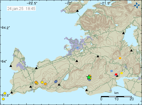
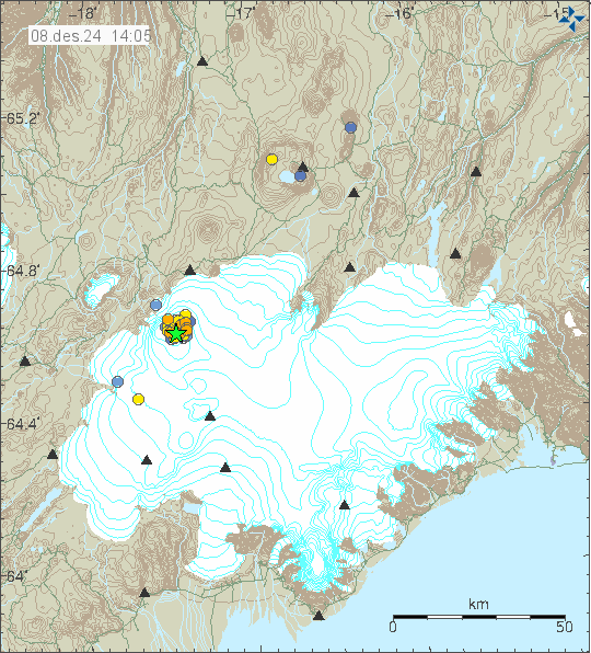
Today (24-January 2025) at 06:06 UTC an earthquake with the magnitude of Mw3,0 took place in Brennisteinsfjöll volcano. This doesn’t seem to have connected to magma movement in this area or volcano. This looks like more like a tension related earthquake. It was probably not related to inflation in Svartsengi volcano.
Green star in Brennisteinsfjöll volcano. Copyright of this image belongs to Icelandic Met Office.
There is a risk of stronger earthquakes in this area. Currently there are no signs that this connected to magma movement in this area.
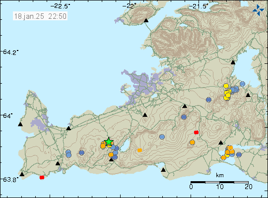
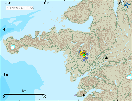
Today (18-January 2025) at 13:45 UTC an earthquake with magnitude of Mw3,2 took place in Krýsuvík volcano, this was just east of Keilir mountain. This earthquake was felt according to news reports. This resulted in a small earthquake swarm at this location.
Earthquake activity east of Keilir mountain. Copyright of this image belongs to Icelandic Met Office.
This earthquake is not connected to magma movement in this area. This seems to be a tension release in the crust from the inflation of Svartsengi volcano. More earthquakes might happen in this area in next few days and until next eruption starts in Svartsengi volcano in Sundhnúkagígaröðin crater row.
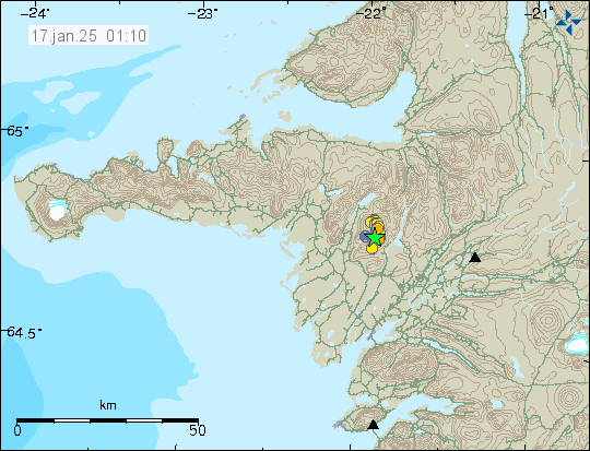
Yesterday (16. January 2025) an earthquake swarm started in Ljósufjöll volcano. This is an area that has had an earthquake swarm since 2020 or 2021. Largest earthquake in this swarm had a magnitude of Mw3,2.
Earthquake activity in Ljósufjöll volcano system. Copyright of this image belongs to Icelandic Met Office.
This earthquake swarm aligned it self with fault lines in the area. That is a change from earlier earthquake activity. Depth of the earthquake has also been decreasing. Its now around 14 km, from 17 to 23 km as it was before. Based on the earthquake activity, the amount of magma remains low and when the amount of magma is low. Its less likely to erupt. It rather is just stuck in the crust. However, if the amount of magma increases, that is going to increase the chance of an eruption in this area. This might take years, if not decades to happen as it stands now. Quick change seems unlikely at the writing of this article.
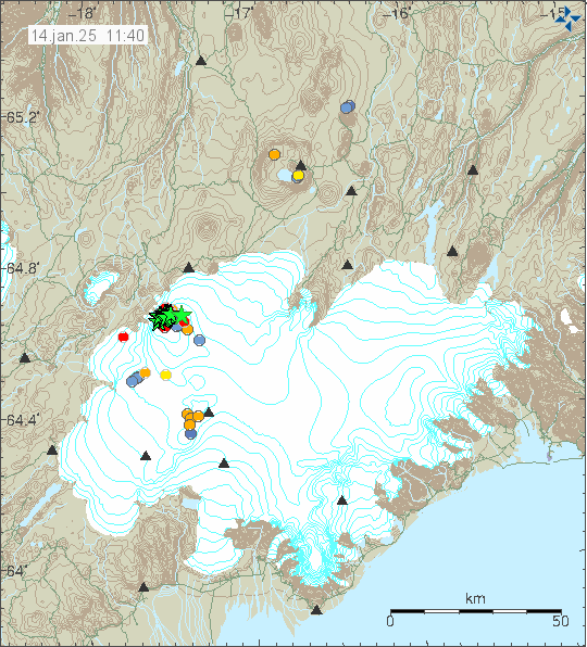
Today (14-January 2025) at 06:08 UTC an dyke intrusion started in Bárðarbunga volcano. This dyke intrusion lasted until around 09:00 UTC and might still not be over, even if the activity has stopped at the writing of this article. Largest earthquakes had the magnitude of Mw5,2 (USGS, EMSC). More than a dozen earthquakes with magnitude from Mw3,0 to Mw5,0 took place in this earthquake swarm.
The earthquake activity in Bárðarbunga volcano. Copyright of this image belongs to Icelandic Met Office.
The main activity was in the western part of the caldera. According to the experts, this earthquake swarm looks close to what happened in Bárðarbunga volcano before it erupted in Gjálp (Wikipedia, Icelandic) in the year 1996. Then a earthquake swarm started like this, slowed down for few days before it increased again and the eruption happened. It is unclear what direction the dyke might move to, but most likely is south-west in the direction of Torfajökull volcano and Katla volcano. If that happens, such dyke activity might get those volcanoes upset or start and eruption in them.
I am going to post update as needed for Bárðarbunga volcano as this activity continues.
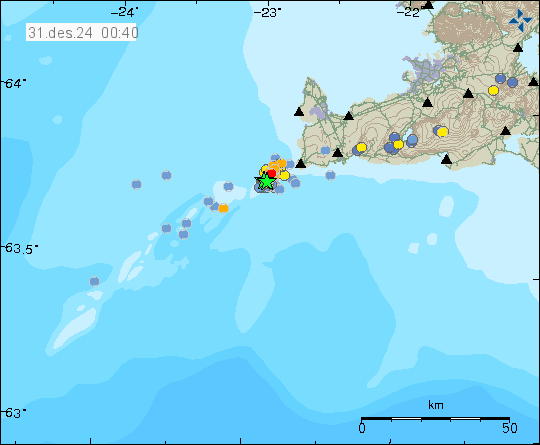
On Sunday (29-December 2024) and yesterday (30-December 2024) an earthquake swarm took place in Reykjanes volcano, close to Eldey island. Largest earthquakes in this earthquake swarm had magnitude of Mw3,2 and Mw3,6. Over 200 earthquakes have been recorded at the writing of this article. This earthquake activity is possibly still ongoing. But this earthquake activity happens in waves with quiet time period between them.
Earthquake activity on Reykjanes ridge. Copyright of this image belongs to Icelandic Met Office.
It is unclear if this earthquake activity is because of tectonic movement or magma activity. I do suspect that this activity is because of magma movement in this area, based on earthquakes location, since it was focused on rather small locations. There are however no signs that this earthquake swarm is a start of an eruption at this location currently. There are limited GPS data on Reykjanes volcano, since part of it is under the ocean.
Today (19-December 2024) at 12:18 UTC an earthquake with magnitude of Mw3,1 took place Hamarinn volcano. Few smaller earthquakes also followed, there was also small amount of earthquakes before the largest earthquake.
Green star in Hamarinn volcano. Copyright of this image belongs to Icelandic Met Office.
Last time this happened in Hamarinn volcano an eruption that lasted 6 to 8 hours happened in July 2011. When or if an eruption happens in Hamarinn volcano is impossible to know. This activity might quiet down again. If there is a ongoing increasing earthquake activity, then a eruption in Hamarinn volcano is more likely, but it is impossible to know if it is going to happen.
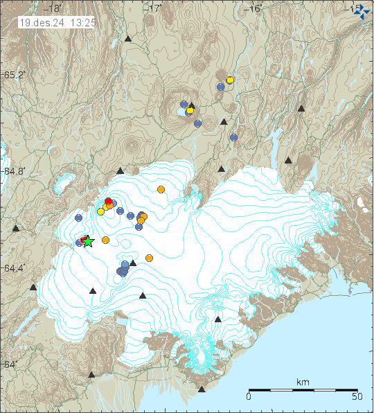
Yesterday (18-December 2024) at 22:50 UTC. The strongest earthquake since modern recording started took place in Ljósufjöll volcano. This earthquake was felt in Borgarnes, Akranes and other nearby towns. Magnitude of this earthquake was Mw3,2 at depth of 18 km. The reason for this earthquake is injection of magma at depth at this location.
The earthquake activity in Ljósufjöll volcano. Copyright of this image belongs to Icelandic Met Office.
As it looks now. An eruption is unlikely to happen in Ljósufjöll volcano. In the last few months, the depth of this earthquake activity has not changed that much and continues to be at 15 to 25 km depth in this area. The crust is also thicker and more dense in this part of Iceland and that requires more magma to break up to the surface. At the writing of this article, that has not changed since this earthquake activity started. As more magma injects into this location is going to result in more earthquakes. Currently, the amount of magma in this injection seems to be minor and is unable to break a path to the surface.
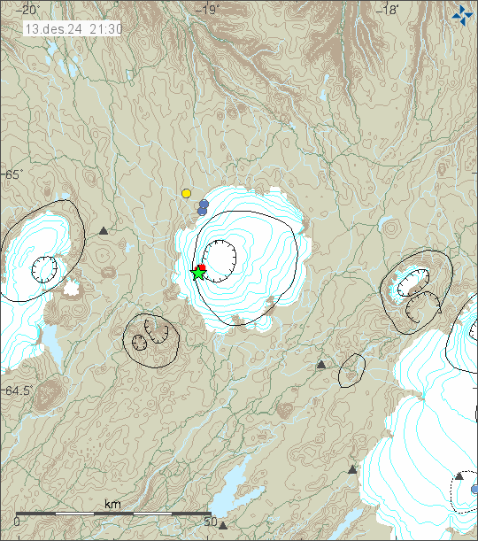
One of Iceland largest volcanoes has been having an earthquake swarm this evening on 13-December 2024. This is the Hofsjökull volcano. Largest earthquake in this swarm had a magnitude of Mw3,3 at 8,8 km depth. Other earthquakes have been smaller.
Earthquake activity in Höfsjökull volcano. Copyright of this image belongs to Icelandic Met Office.
This earthquake swarm seems to be over. However, the problem with Hofsjökull volcano is that earthquake activity often stops and then resumes several hours to days later in the same location. If that happens now I do not know.
During the night of 8-December 2024 at 01:49 UTC an earthquake with magnitude of Mw5,2 took place in Bárðarbunga volcano. This is a inflation related earthquake, as Bárðarbunga volcano continues to inflate from the collapse during the 2014 and 2015 eruption.
The earthquake activity in Bárðarbunga volcano. Copyright of this image belongs to Icelandic Met Office.
A lot of smaller earthquakes also happened before and after the main earthquake. This is not unusual, there are just more of them now. Why that happened is not clear. This is an ongoing earthquake activity in Bárðarbunga and is going last for the next 30 to 90 years in the longest. Depending on how this evolve in Bárðarbunga volcano.
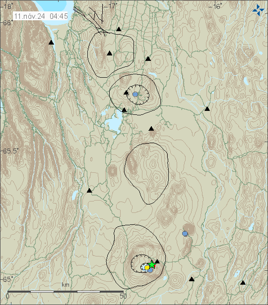
Yesterday (10-November 2024) at 08:13 UTC an earthquake with the magnitude of Mw3,0 took place in Askja volcano. This earthquake had few minor aftershocks, but nothing more happened following this earthquake.
Earthquake activity in Askja volcano. Copyright of this image belongs to Icelandic Met Office.
There is magma flowing into Askja volcano at current time. However I do not think this time it is going to result in a eruption. If this earthquake is connected to this magma inflow I do not know.
Cookie acceptance
We use cookies on our website to give you the most relevant experience by remembering your preferences and repeat visits. By clicking “Accept”, you consent to the use of ALL the cookies.
This website uses cookies to improve your experience while you navigate through the website. Out of these cookies, the cookies that are categorized as necessary are stored on your browser as they are essential for the working of basic functionalities of the website. We also use third-party cookies that help us analyze and understand how you use this website. These cookies will be stored in your browser only with your consent. You also have the option to opt-out of these cookies. But opting out of some of these cookies may have an effect on your browsing experience.
Necessary cookies are absolutely essential for the website to function properly. This category only includes cookies that ensures basic functionalities and security features of the website. These cookies do not store any personal information.
Functional cookies help to perform certain functionalities like sharing the content of the website on social media platforms, collect feedbacks, and other third-party features.
Performance cookies are used to understand and analyze the key performance indexes of the website which helps in delivering a better user experience for the visitors.
Analytical cookies are used to understand how visitors interact with the website. These cookies help provide information on metrics the number of visitors, bounce rate, traffic source, etc.
Advertisement cookies are used to provide visitors with relevant ads and marketing campaigns. These cookies track visitors across websites and collect information to provide customized ads.