Grímsvöt eruption appears to be over

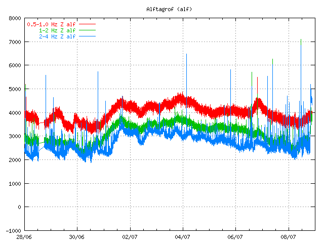
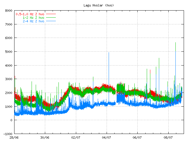
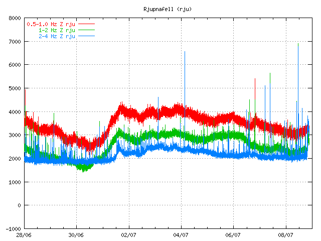
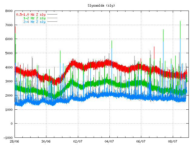
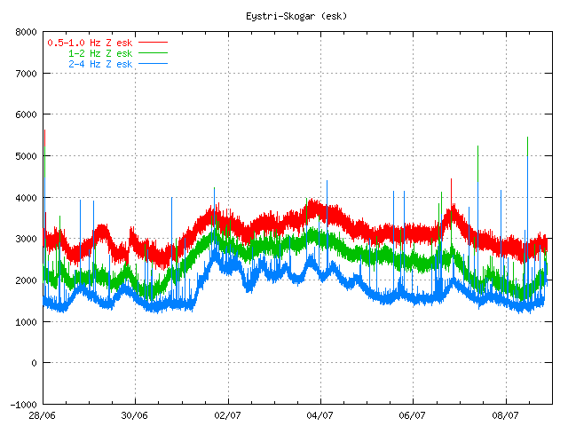
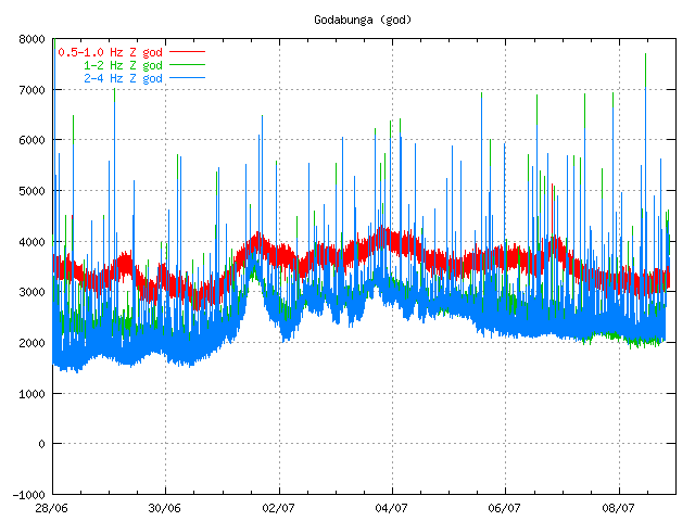
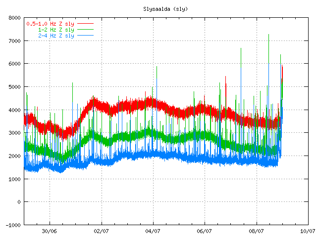
Given the current tremor plot on Icelandic Met Office and with reports it seems that the eruption in Grímsvötn (Grímsfjall volcano) is about to be over for now. It is impossible to know if the eruption is going to resume soon or not. But at the moment this eruption seems to be over as it looks now. If it remains like that has to be seen however.

This drop in the eruption has been confirmed by Icelandic Met Office tremor plots.

Tremor plots as of 07:00 UTC. This tremor plots are from Icelandic Met Office web site. Copyright of this pictures belongs to Icelandic Met Office.

Early news this morning in Iceland reported that steam was only coming from the main crater of Grímsvötn.

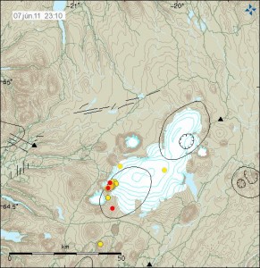
Other interesting development is that an earthquakes have started to appear SSE of Grímsfjall volcano (Grímsvötn). It is unclear why earthquake are happening at this location. But dike intrusion at this location is not impossible.

The reason for flight problems in Europe is because of the volcano ash that was ejected into atmosphere in the first days of the eruption. It is going take few days for that volcano ash to disappear from the air. Until that happens, it is going to create problems for air traffic.

Update 1: Even if the eruption appears to be over the tremor is still high. I do not know why that is. It is a question why that is or if this is just break in the eruption or not. Only time is going to tell what happens next.

Update 2: There was an news report this morning that before 02:00 UTC there was an spike in activity in Grímsvötn that did shoot the ash cloud up to 8 km. But that spike did only last for few moments before it was over. Rúv has released video here (Windows Media Player) of the eruption site.

Updated at 07:37 UTC.
Updated at 07:50 UTC.
Updated at 08:33 UTC. Blog post title updated.
Updated at 11:42 UTC.
Updated at 12:23 UTC.

Less powerful eruption in Grímsvötn / Grímsfjall volcano

It has been reported in the news that the eruption in Grímsfjall volcano (also known as Grímsvötn) is getting less powerful as the time passes. This is perfectly normal for an eruption in Grímsfjall volcano.

This can also be seen on tremor plots around Grímsfjall volcano. They clearly show the eruption getting less powerful over time. It has also been reported in the news that the material that is being erupted is now estimated to be 100 tons/second at the moment. But just yesterday it was 1000 tons/second and up to 2000 tons/second. The eruption is currently stable, even if it smaller then it was in the first few days. It is also not certain if this eruption is going to turn into lava eruption. As there seems to be enough water to continue ash phase of the eruption for the next few days.

Grímsfjall SIL station. It clearly shows the eruption getting less powerful over time.

Kálfafell SIL station. It shows the same pattern as Grímsfjall SIL station. Copyright of both pictures belongs to Icelandic Met Office.

In the news it has also been suggested that there might be less or no influx of new magma from great depth. But I do not know for sure if that is just speculation or not.

The ash plume has only got up to 3 to 5 km according to news reports. This means that has dropped a good distance in the last 24 hours. But yesterday it did reach up to 5 to 9 km. So ash is not spreading far away as it did earlier in this eruption. What is creating flight disruption in Europe and over Iceland is the volcano ash that was ejected in the first few days of the eruption. It has also been an big problem in Iceland is the volcano ash that is getting air blown on the ground. The ground is dry so the volcano ash moves easily because of that. Update 1: It has also been reported that the ash that did was ejected on the first day of Grímsvötn eruption was like all the ash ejected in the Eyjafjallajökull volcano eruption in the year 2010. They also say that this eruption was about the size of normal Katla eruption in there own estimate. News about this can be found here (Icelandic, picture)

Scientists did go today up to Vatnajökull glacier in an attempt to get close the eruption site. Flight over the Grísmfjall volcano is also taking place in an attempt to see the eruption site and take measurements of the eruption.

Update 2: There has been an minor spike in the tremor plot in the last hour or so. I do not know why that is. But this suggest that the eruption is growing in power again.

Icelandic News about it. Use Google Translate if you want some funny reporting.

Dregur úr gosvirkni (Rúv.is, Icelandic)
Dregið hefur úr eldsgosinu – umtalsvert minni gosefnaframleiðsla (Vísir.is, Icelandic)
Dregur úr gjóskuframleiðslu (mbl.is, Icelandic)

Please note that information here might get outdated really fast and with no warning at all!

Post updated at 17:57 UTC.

General overview of Grímsvötn eruption on 23. May 2011 at 20:33 UTC

This is a general overview of Grímsvötn eruption on 23. May 2011 at 20:33 UTC.

Ash cloud: The ash cloud is still going strong. It is however a bit lower then in first few days. Measurements of the ash plume now says that it is between 5 to 9 km. Because of that it does not appear on the radar at IMO. The ash cloud has now been detected all over Iceland, except for the most western part of Iceland (Westfjod). In the areas closest to the main ash cloud the visibility is from 1 meter and up to 500 meters when it is at it’s best. Ash fall is expected to last for the next few days, or until the crater does not get any water into it to make the ash. The ash cloud is expected to reach Scotland tonight (Rúv, Icelandic). BBC News about cancelled flights due the ash cloud. Farmers live stock has started to die due to the ash cloud. It is unknown how the wild life is doing while the ash cloud covers part of south Iceland. Current output of the Grímsfjall volcano is about 1000 to 2000 tons of ash pr second. It was around 10,000 tons of ash pr second during the first days of the eruption.

Rúv News, Öskufall næstu daga (Icelandic, Rúv.is)

Eruption: Even if the ash cloud is lower now. It appears that the eruption is still going strong. In the evening news at Rúv it was reported that there was a chance the magma that powers this eruption might be from a great depth (more then 20 km). Tremor graphs that are online show and suggest that the eruption is still at full power. The reason why they are at lower noise level is most likely due to fewer explosion in the eruption, as less water is in the crater. When water no longer goes into the crater it turns into lava eruption. There is also an speculation that new fissures might open up in this eruption where there is more glacier cover (evening news on Rúv). But that would mean flash glacier flood and new ash cloud when the eruption would break the glacier covering it. But so far this has not happened and is nothing but a speculation. It would mean earthquake activity when the magma would break the crust, as happened when the eruption did start on 21. May 2011.

GPS data: According to report from IMO and University of Iceland the deflation now has been 50 cm to northwest and has subsided 25 cm. According to the report this about 60% larger then after the eruptions in the year 1998 and in the year 2004.

Web cameras: Grímsvötn Míla web cam is now up and running. It should be possible to see the eruption when an ash cloud is not in the way. But so far that has been the case.

Please note that information here might get outdated really fast and with no warning at all!

Updated at 20:42 UTC.

Grímsfjall/Grímsvötn volcano eruption update at 21:54 UTC

This is a minor update to the Grímsfjall volcano / Grímsvötn eruption.

Process of the eruption: The harmonic tremor on the SIL stations around Grímsvötn is increasing again after it did drop a little bit down earlier today. Following this the ash plume has again appeared on radar images from Icelandic Met Office. Currently however the ash plume is just around 10 km high. According to the news, the eruption is made out of basalt. But that is a common eruption type for Grímsvötn. The ash cloud is formed when hot magma gets into contact with ice and water and explodes on contact. This eruption is now expected to many times larger then the eruption in Eyjafjallajökull volcano last year.

Ash cloud: The ash cloud does now covers most of Iceland, except the northern part of west Iceland (for the moment) and east Iceland (for the moment) but that is expected to change in the next 24 to 48 hours. Ash has been reported in most town in Iceland. That includes Reykjavík, Akureyri, Selfoss (heavy ash cloud) and more. According to web cameras there is heavy ash fall close to Hekla volcano from Grímsfjall volcano (web camera pointed towards Hekla is here, Eyjafjallajökull is here). Due the ash cloud all flight to and from Iceland has been grounded until this ash clouds goes away.

Earthquakes: Few earthquakes are recorded. But only two earthquakes have been recorded around Grímsfjall volcano and close to in the past few hours. But that does not mean that they are not happening. But they might simply be lost in the harmonic tremors from the eruption.

Other: Nothing at the moment.

Please note that information here might get outdated really fast and with no warning at all!

Grímsvötn/Grímsfjall volcano eruption update at 08:52 UTC

This is a short update on Grímsfjall volcano/ Grímsvötn eruption. This is short update because a lot of details in this eruption are still unclear at this moment.

Process of the eruption: The eruption in Grímsvötn is still growing strong. Icelandic Met Office SIL sensors show a uneven process in the eruption. But they also show that the eruption has dropped a little bit in power since it originally started in yesterday. That is normal for a eruption in Grímsfjall volcano. It starts strong and then slowly drops in power over time. But what is unusual for this eruption is the uneven process that is taking place (seen with SIL data) in the eruption. What that means is unclear. It is more unclear what it means to the eruption. While it is unclear at the moment. It appears that the eruption is taking place a little south of the eruption in the year 2004. But that is unconfirmed, as ash cloud to the ground blocks the view the eruption site.

Ash cloud: The ash plume is reported to have reached 20 km high yesterday. From as I can gather that has not changed. This ash plume appears be made from two to three ash cloud columns. With the strongest one getting the highest. A lot of lightning is taking place in the ash cloud. Due to the ash cloud, all flight from and to Iceland has been cancelled until further notice (don’t ask question about that here, ask your airliner for information about this closure). The ash did start to fall in populated areas few hours after the eruption did start in Grímsvötn. The ash is described as fine, but more crude (bigger particles) then the ash from Eyjafjallajökull volcano eruption in the year 2010. The ash cloud is moving west in higher layers of the atmosphere over Iceland. While it moving south in the lower layers of the atmosphere as the wind is from north in Iceland at the moment.

Earthquakes: After the magma has found it’s way to the surface. All earthquake activity did stop in Grímsfjall volcano. This is normal. But what is unusual is that there have been few earthquake swarm after that in Grímsfjall volcano. I do not know what it means or why this is happening. But this is interesting development.

Other: The earliest estimation on the size of the Grímsfjall volcano eruption 2011 is that this looks like it is a bigger eruption then in Eyjafjallajökull volcano eruption in the year 2010. But that is closer to speculation based on visual observation of the eruption. But it is clear that this eruption is bigger then the year 2004 eruption in Grímsfjall volcano.

A new video has been relased of the eruption. It is from yesterday when the eruption was starting.

Update 1: They now say that this is the largest eruption in Grímsvötn / Grímsfjall volcano in the last 100 years. Rúv news about this, Stærsta gos í Grímsvötnum í 100 ár (Icelandic).

Please note that information here might get outdated really fast and with no warning at all!

Update at 09:24 UTC.

Ash cloud confirmed from Grímsfjall volcano

A eruption ash cloud has been confirmed from Grímsfjall volcano. I do not know how high it currently is. But Icelandic news is reporting that the cloud is rising fast and high (estimated 3000 – 4000 meters and rising). Explosions have been seen from good distance.

Update 1: They estimate that there are 10 to 12 hours until the glacier flood appears from this eruption. The ash cloud can be tracked with lighting map here.

News about this.

Strókur rís hátt yfir Grímsvötnum (Rúv.is, picture)
Tíu til tólf klukkutímar í hlaup (Rúv.is, new picture)
Allir viðbragðsaðilar komnir af stað vegna gossins (Vísir.is, Picture)
Mjög öflug gosstöð (mbl.is, New picture)

Updated at 19:41 UTC.
Updated at 19:53 UTC.
Updated 20:21 UTC.

Earthquake swarm close to Geirfuglasker on Reykjanes Ridge

Today at 15:08 UTC a earthquake swarm did start close to Geirfuglaskeri on Reykjanes Ridge. This earthquake swarm has so far been small, with the largest earthquake having the automatic size ML2.4 with the depth of 10 km.

So far this earthquake swarm has remained small. But it is unclear if this earthquake swarm is going to continue. But there was a break in this earthquake swarm from 16:12 UTC too 18:55 UTC. But I did think that this earthquake swarm was over, until it did start again.

It is impossible to know if this earthquake swarm is over or not.

Deep earthquake in Herðurbreiðarfjöll volcano (Askja volcano fissure swarm)

Today at 06:57 UTC in Iceland there was a ML0.2 earthquake east of Herðurbreiðarfjöll volcano. While the size of this earthquake is really small. It is the depth that is interesting in this case. The depth of this earthquake was at 25,7 km depth. This is a interesting depth given the increase in earthquake activity in Askja volcano.

According to my geological map (a rather new one) the mountain named Herðubreiðarfjöll is a volcano that is inside Askja volcano fissure swarm. A common thing that happens in Iceland. This area has many active fault lines and has erupted in modern time. But I do not know when this volcano last erupted, as there are no information on Herðurbreiðarfjöll volcano activity in the GVP database and I have not found anything useful on the internet about this volcano.

Earthquake activity continues in Askja volcano. But at slower rate then before. Other then this, it is quiet in Iceland as it has been for the past few weeks.

Earthquake in Askja volcano last night

Here is a picture of a earthquake that took place in Askja volcano last night. This earthquake was bearly visable on my geophone close to Hekla volcano. From this data it is clear that the earthquakes are created by magma movements inside Askja volcano. But the earthquake swarm is taking place on the edge of Askja volcano main system. It is not happening outside as it might appear.

It is also worth pointing out that not all of Askja volcano earthquakes might appear on the automatic SIL system. But most of them should do so. As Askja volcano is remote and in a unpopulated area there should not be any damage from a eruption. The only damage might happen if there is a eruption in Askja caldera lake due to ash cloud that might form.


Askja volcano earthquake. This is low pass filtered at 1Hz. This image is released under Creative Commons License, see top link for more information. Click on this picture for full resolution.

This earthquake has magma signature from the looks of the earthquake signal. But due to distance it is hard to be sure on that.

When this is written a tremor pulse appears to be starting in Askja volcano. But this might also be a swarm of micro earthquakes taking place in Askja volcano without the earthquakes appearing on the automatic SIL system. At this point it is hard to know for sure, as this activity is new.


Locations of the earthquakes in relations to the Askja volcano system. As can be seen on this map from Icelandic Met Office, the earthquakes are clearly inside Askja volcano. Even if they are not at the main caldera. Picture is from Icelandic Met Office web site. Copyright of this picture belongs to Icelandic Met Office.
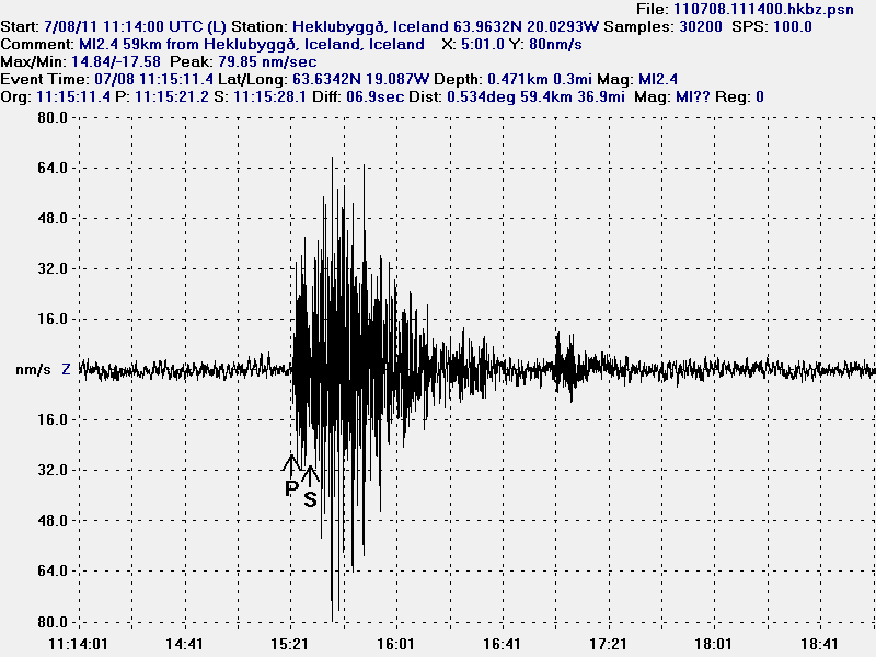
Blog post updated at 16:37 UTC on 5 May 2011. Picture is added.